The Extremely Low Frequency Engineering Project for Underground Exploration
Jinxun Lu, Xinjun Zhuo, Yong Liu, Guoze Zho, Qingyun Di
a China Ship Research and Development Academy, Beijing 100101, China
b Wuhan Maritime Communication Research Institute, Wuhan 430079, China
c Institute of Geology, China Earthquake Administration, Beijing 100029, China
d Institute of Geology and Geophysics, Chinese Academy of Sciences, Beijing 100029, China
1. Introduction
Super-low-frequency (SLF) (30–300 Hz) electromagnetic technology was first used in military to submarine deep water communications. In the 1950s, to strengthen the concealment and survivability of strategic missile nuclear submarines, both the United States and the Soviet Union began to study SLF communications, with the aim of achieving communications between land command centers and submarines at depths of below 100 m and distances of thousands of kilometers. In 1969, the US Navy built an SLF test facility in the low-conductivity granite area of Clam Lake, Wisconsin (Wisconsin test facility (WTF)). Later, in 1972,the Navy successfully established communications between a submarine at an underwater depth of 102 m and a distance of 4600 km away.Then,in the 1980s,the United States upgraded the WTF station to an official work station and built a new test facility in Michigan (Michigan test facility (MTF)). At the same time, the Soviet Union built the Zeus station in the low-conductivity area of the Kola Peninsula and was also successful in implementing the strategic command communication with nuclear submarines underwater [1–5].
In the 1990s,the United States and Russia began to study communication problems at lower frequencies (0.1–30 Hz), while expanding the fields of research to geophysics, space physics, and more. An international extremely low frequency (ELF) research project (Fig. 1) was also publicly proposed.
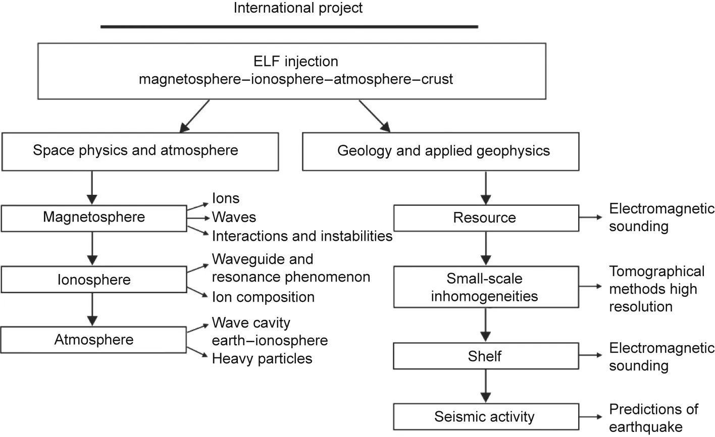
Fig. 1. The international ELF research project.
At this point,it should be noted that,according to Chinese radio frequency division standards, the frequency range of 0.1–300 Hz includes the tremendously low frequency (TLF) (0.03–0.3 Hz), ELF(0.3–30 Hz), and SLF (30–300 Hz) bands. For easier expression,we refer to 0.1–300 Hz as the ELF band in this article.
China’s first ELF test facility was established in the 1990s,based on the introduction of Russian technologies, providing a hardearned platform for theoretical and applicational research on ELF electromagnetic technology. In 2000, the academicians Jianxun Lu and Zongjin Ma were the first to carry out a research project on this topic under the Chinese Academy of Engineering. The project, which was named ‘‘Research on Seismic Prediction and Underground Resource Detection System Using ELF/SLF Radio Waves,” studied the earth–ionosphere waveguide propagation technology of ELF electromagnetic waves in detail[6,7].To address the shortcomings of low power,small signal coverage(10–20 km),and shallow detection depth (1–1.5 km) of the mobile emission sources used in the existing artificial-source electromagnetic method (e.g., controlled source audio frequency magnetotellurics(CSAMT)) [8], a new artificial-source electromagnetic method was proposed by the project, which focused on the application of fixed high-power transmission signals propagating through an earth–ionospheric waveguide. This method greatly expands the radius of applicable signals to thousands of kilometers and deepen the lower exploration depth to 10 km. The scope of application of the existing artificial-source electromagnetic method was also greatly expanded.In order to distinguish this new technology from other geophysical electromagnetic technologies, we named this method as the wireless electromagnetic method (WEM).
To better study and apply the WEM method, and to exert its effectiveness in resource detection and earthquake prediction, a construction plan for the infrastructure required to apply the WEM method was proposed: the ELF engineering project for underground exploration (also known as the WEM project) [9]. In 2005, several tests of WEM applications in resource detection and earthquake prediction were carried out by the ELF test facility.The tests generated numerous preliminary positive results, suggesting that this method is effective[10,11].In 2006,the WEM project was listed as one of the major National Science Technical Infrastructure Construction Projects in the 11th Five Year Plan Period in China.
2. Overview of the WEM project
2.1. Goals
The goals of the WEM project are as follows.
(1)To construct experimental facilities such as an ELF transmission station, which has the ability to transmit 0.1–300 Hz ELF electromagnetic signals with a high signal-to-noise ration (SNR),effectively covering all Chinese land and territorial waters.
(2)To carry out theoretical and methodological research on the WEM method and on its applications in resource exploration and earthquake prediction by taking advantage of the deeper propagation and larger signal-coverage mechanism of ELF electromagnetic waves.
(3)To explore new theories of deep resource exploration under complex geological environments and new laws and mechanisms of the electromagnetic anomaly precursors of earthquakes, and to promote original research results in these areas of great scientific significance.
(4) To promote the development of disciplines such as geophysics, space physics, and radio physics.
2.2. Achievements of the WEM project
Construction of the ELF transmitting station and other supporting infrastructure, both for resource exploration and earthquake prediction,has been completed.Further research on the principles and engineering applications of the WEM method has been carried out at these facilities on topics such as resource exploration,earthquake prediction,and continental shelf signals testing,and a number of achievements have been obtained, as described below.
2.2.1. Establishment of the first civilian high-power ELF transmission station
A high-power transmission station (known as a WEM station for short) was established in a low-conductivity area in central China. The station has two nearly orthogonal transmitting antennas: The east–west antenna is about 80 km long, and the north–south antenna is about 60 km long.Each antenna is equipped with a 500 kW transmitter(Fig.2 shows the equipment and facilities of the transmitting station)and is grounded at both ends.The antennas can transmit signals in 98 frequencies within the 0.1–300 Hz ELF band approved by the Radio Administration of the Ministry of Industry and Information Technology of the People’s Republic of China.The frequency accuracy of the WEM station signals is better than 3 × 10⁻⁸, while the frequency stability is better than 3 × 10⁻⁸. The stable and high SNR of the WEM station signals fulfills the requirements for resource exploration,earthquake prediction, and other breakthrough scientific research fields (Fig. 3).
After the WEM station was built,the strength of its transmitting signals was tested nationwide (from Mohe in Heilongjiang Province, north China, to Kuitun in Xinjiang Uygur Autonomous Region, west China). The test results showed that the coverage radius of the signals at 0.5–300 Hz was as high as 2000–3000 km with an SNR of 10–20 dB, while the coverage radius of signals at 0.1–0.5 Hz was 1000–2000 km with an SNR of 10–20 dB (Table 1).
2.2.2. Results of underground resource detection research and application
The WEM method is a new artificial-source electromagnetic method that differs from existing artificial-source electromagnetic technologies in terms of its propagation mechanism and application. Based on the characteristics of the WEM method, theoretical research was carried out on the ELF electromagnetic waves propagation mechanism and on the application of WEM in resource detection. In addition, an ionosphere–atmosphere–earth coupling model of ELF electromagnetic waves propagation and a WEM data-processing platform were established. As a result, ultra-wide networked deep three-dimensional (3D) ELF electromagnetic exploration can be implemented to obtain high-precision and high-resolution electrical structures within a depth of 10 km,which can provide reliable geophysical models for oil, gas, and mineral resource exploration [12–15].
During the construction of the WEM project, many experimental explorations were conducted in the Caosiyao molybdenum mining area (Inner Mongolia Autonomous Region), the Biyang Basin (Henan Province), the Mingyuexia structural area(Chongqing and eastern Sichuan Province), and the Suining area(Sichuan Province)(Figs.4 and 5).All of these explorations verified that the WEM method has the ability to improve geophysical modeling for metallic minerals and oil and gas exploration, in comparison with conventional techniques.
2.2.3. Results of earthquake-prediction research and application
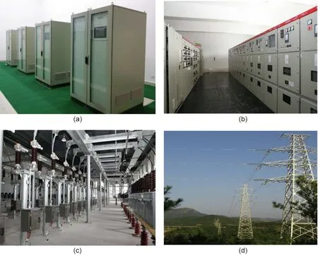
Fig.2. Equipment and facilities of the WEM transmitting station.(a)The 2×500 kW transmitter;(b)the control cabinet;(c)the antenna tuning room;(d)the feeder tower.
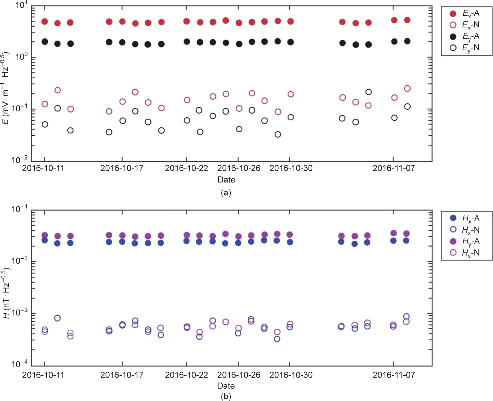
Fig.3. Comparison of(a)electric-field(E)and(b)magnetic-field(H)power spectral densities from the WEM station and natural-source.x:north–south component;y:east–west component; A: WEM signals; N: natural signals.

Table 1 Results from the strength test of the signals transmitted by the WEM station.
An ELF electromagnetic signal observation network composed of 30 fixed stations and two mobile stations(Tables 2 and 3),which can continuously monitor both WEM signals and natural signals in the ELF band at same time, was established in the key earthquake disaster-prevention areas of the Beijing capital circle and the southern section of the north–south earthquake belt. An earthquake service subsystem was established,including data transmission,monitoring,processing,management,and analysis services in collaboration with the National Seismic Network. The subsystem can monitor real-time dynamic changes in both the electromagnetic field and underground electrical structure (e.g., electromagnetic time series, frequency spectrum, and apparent resistivities)in the Beijing capital region and the southern earthquake belt. All these data can be used to study the relationship between and mechanism of earthquakes and electromagnetic anomalies, and improve our ability to monitor and predict earthquakes [16–18].
Since 2015, the electromagnetic monitoring network has produced a large amount of observational data covering the time duration of many earthquake events, including a magnitude 5.1 earthquake in Yangbi (Yunnan Province)on March 27, 2017, magnitude 7.0 earthquake aftershocks in Jiuzhaigou(Sichuan Province)on August 8, 2017, and a magnitude 5.4 earthquake in Qingchuan(Sichuan Province) on September 30, 2017. Changes in the electromagnetic field or underground electrical structure before and after the event were clearly recognized before and after these earthquakes. For example, a pulsation of apparent resistivity and impedance phase at 74 Hz appeared a few weeks before the Yangbi magnitude 5.1 earthquake (Fig. 6). As another example,the fluctuation range of 4 Hz electromagnetic power spectral density transmitted by WEM station began to increase eight days before the Qingchuan magnitude 5.4 earthquake (Fig. 7). At present, electromagnetic data from the WEM earthquake subsystem has been included into the basic earthquake-prediction database as one of the earthquake-prediction parameters.
2.2.4. Other breakthrough scientific research and applications
Based on the information gained from the international ELF research project, ELF electromagnetic technology can be widely applied in many scientific research fields,such as geophysics,space physics, and more. During the construction of the WEM project,experiments on continental shelf signals were carried out, which demonstrated that the signals transmitted by the WEM station can be received 300 m underwater in the South China Sea. These experiments laid a solid foundation for continental resources exploration using the WEM method,expanded the application scenarios of ELF electromagnetic technology,and promoted the development of the WEM station.
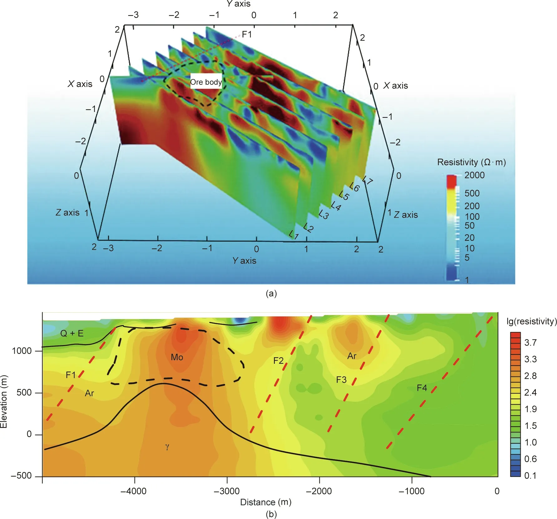
Fig. 4. Comprehensive interpretation results from WEM exploration in the Caosiyao molybdenum mine, Inner Mongolia. (a) 3D view of resistivity slices, black dashed line indicates the horizontal range of the ore body;(b)inversion result of a cross-section,black dashed line shows the vertical range of the molybdenum deposits.L1–L7 mean the number of survey line; F1–F4 mean the number of faults; Q is the Quaternary strata; E is Cenozoic Erathem strata; Mo is the molybdenum ore; Ar is Archean strata;γ is granite.
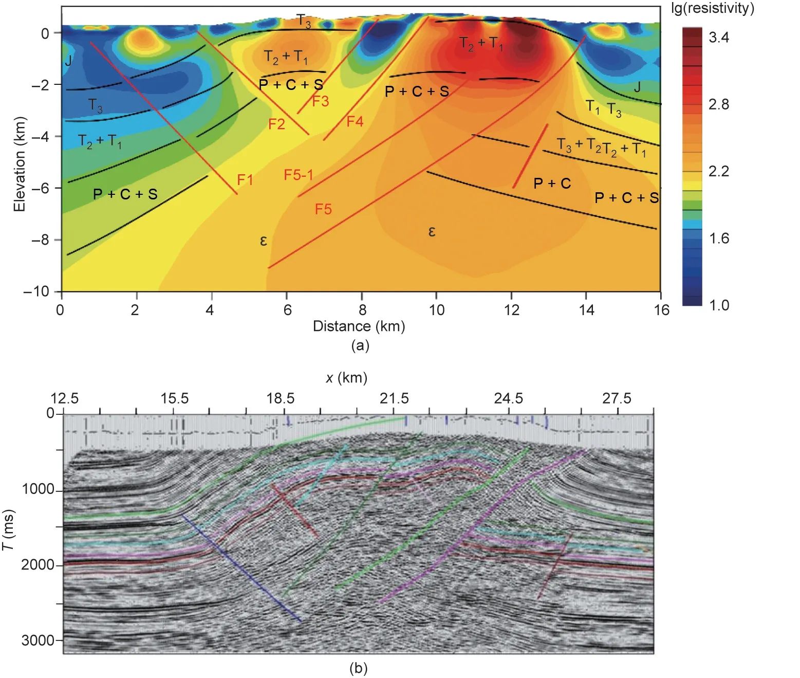
Fig. 5. Comparison of (a) WEM results and (b) seismic travel time (T) tomography section of an oil/gas structure in Mingyuexia, Chongqing. J is the Jurassic strata; T is the Triassic strata and the subscripts 1, 2, 3 are different stage; P is Permian strata; C is Carboniferous strata; S is Silurian strata;ε is Cambrian strata.
3. Key technologies and innovations
The following key technologies and innovations have been developed within the WEM project.
(1) The WEM method, which is built on earth–ionosphere waveguide propagation technology, combines the advantages of the natural-source electromagnetic method and the existing artificial-source electromagnetic method. With its strong anti-noiseability, large penetration depth, and high accuracy, the WEM method provides a new scientific and technological platform for underground resource exploration, earthquake prediction, and other frontier field research.
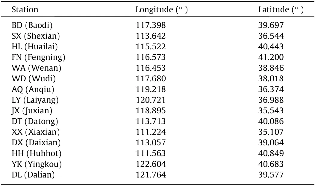
Table 2 Location information of 15 fixed seismic electromagnetic stations in the capital area.
(2)Many key technological achievements have been made,such as the joint formation of high-power ELF signals, dual-band highprecision signal generation, and complex parameter matching and tuning for ELF antennas; which make it possible to achieve efficient high-power ELF output and radiation, and led to the successful development of an ELF transmission system.The transmitted high-precision, highly stable ELF electromagnetic signals meet the research and engineering application requirements.
(3) Theoretical research was carried out on the propagation mechanism of ELF electromagnetic waves, and an ionosphere–atmosphere–earth coupling model was proposed for the simulation of ELF electromagnetic waves. This model enabled ultra-wide networked 3D deep resource exploration by means of ELF electromagnetic waves. A series of large-scale, long-offset, and deep experimental explorations of oil, gas, and mineral resources by means of the WEM method were accomplished for the first time.
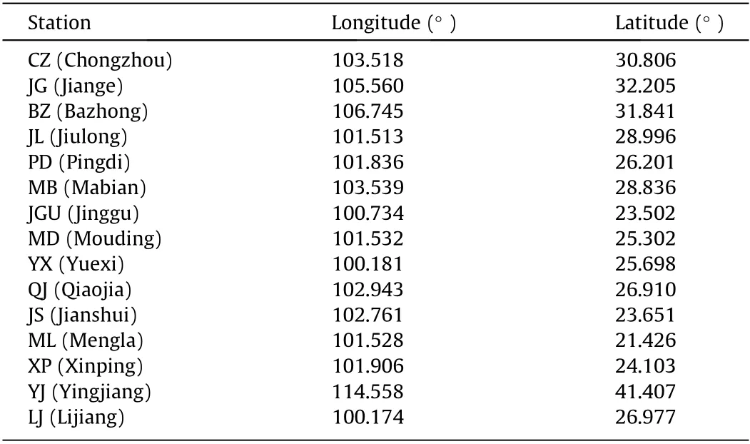
Table 3 Location information of 15 fixed seismic electromagnetic stations in the southern section of the north–south seismic belt.
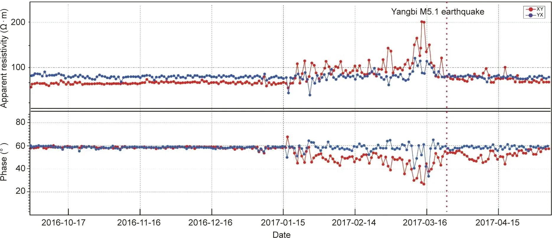
Fig.6. Changes of apparent resistivity(top)and impedance phase(bottom)at 74 Hz before and after the Yangbi earthquake.XY:north–south apparent resistivity;YX:east–west apparent resistivity; M5.1: magnitude 5.1.
(4) The ELF electromagnetic earthquake monitoring network was applied to achieve continuous electromagnetic field observation and rapid analysis. Four-dimensional (4D) dynamic changes in electromagnetic fields and underground structures can now be obtained through the continuous monitoring dataset, which has improved our ability to identify and capture information on electromagnetic anomalies related to earthquake activity. Significant data and results were obtained for earthquake prediction by taking advantage of the ability to simultaneously observe natural-source and ELF signal for the first time in earthquake electromagnetic research.
(5) A wide-area underwater ELF detection method has been proposed. Based on the theoretical calculations and experiments on underwater reception, the ability of ELF to penetrate seawater over an enormous area and depth range has been verified. The achievements of this research form a solid foundation for the‘‘Transparent Ocean” as well as for marine resource exploration and other applications.
4. Engineering applications and development
The construction of the WEM project provides facilities in both software and hardware for research on and applications of ELF electromagnetic technology. It will promote the development of ELF electromagnetic technology, improve our capability for resource explorations and the reliability of earthquake predictions,and be helpful for research in deep geology, space physics, radio physics,and other fields.The WEM project thus has broad application prospects.
4.1. Promoting the development of electromagnetic detection technology
Electromagnetic methods have been developed from naturalsource electromagnetic methods(passive)to artificial-source electromagnetic methods (active), and electromagnetic data-processing methods have been developed from one-dimensional (1D) to two-dimensional (2D) and 3D. The signals of the WEM method are uniformly transmitted by a fixed emission source,which is convenient for large-area networked observations. These signals are characterized by a high SNR and a large coverage area,thereby providing ideal conditions for the development of 3D electromagnetic exploration technology and improving the detection accuracy for underground resources, seismic electromagnetic monitoring, and earthquake prediction. The WEM method will promote the development of artificial-source 3D electromagnetic technology, while driving a leap forward in the development of underground resource exploration and seismic electromagnetic monitoring technology.
4.2. Improving resources exploration technology
The signals in the WEM method are characterized by a high SNR,large coverage area,and great detection depth.By controlling the transmission of high-power,wide-range-coverage,and electromagnetic signals at different frequencies,the electrical structure of a geological section or survey area can be scanned indirectly at different depths of geological layers to form a 2D or 3D image of the electrical structure, which will significantly improve the accuracy of underground structure detection. This technology will play a more important role in oil, gas, and mineral prospecting in complex and deep locations [19].
WEM station signals still maintain a high SNR after being attenuated by seawater.Therefore,the WEM method is also fully applicable to marine resources explorations in continental shelf areas,and provides a new method for the exploration of oil,gas,and mineral resources and geological surveying in China’s continental shelf area.
4.3. Improving electromagnetic monitoring for earthquake research and earthquake prediction
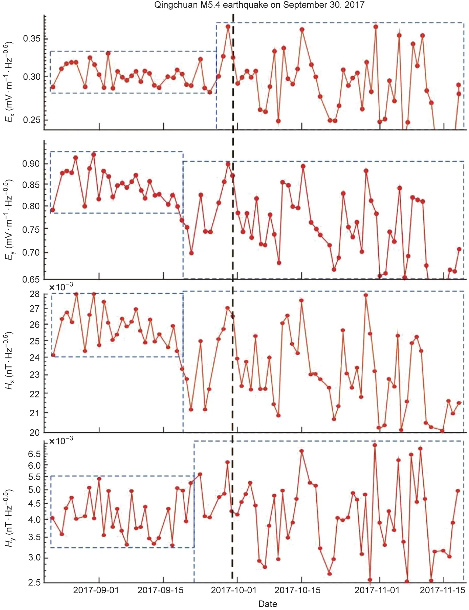
Fig. 7. Fluctuation range of 4 Hz electromagnetic power spectral density before and after the Qingchuan earthquake. M5.4: magnitude 5.4.
The stable and precise electromagnetic signals transmitted by the WEM station have a large coverage area, and thus can be consciously observed by means of a receiver network in certain earthquake-prone areas over a long period of time. This information includes the dynamic electrical parameter variations of the crust structure and the electromagnetic field, which simultaneously carry atmospheric and ionospheric information during the propagation process. Such information can provide us with more comprehensive technical combinations to simultaneously capture deep underground earthquake activity and related ionospheric changes (i.e., ‘‘source and field” anomalous information), which can greatly improve the identification and recognition of anomalies and provide a new scientific research tool for determining the location, time, and magnitude of earthquakes [20].
4.4. Promoting the development of related fields
The WEM project is an important facility for so-called ‘‘deep earth, deep sea, and deep space” scientific research. The stable and high-SNR ELF electromagnetic signals transmitted by the WEM station can be used for research in space physics, atmospheric physics,geology,applied geophysics,and military communications, thereby promoting the progress of disciplines such as geophysics, space physics, and radio physics in China.
5. Conclusions
The WEM method and its applications, as proposed during the WEM project, involve many disciplines such as radio communication and geophysics. This brand new method has achieved many breakthroughs. When the WEM project was originally going through the acceptance process, the participating experts gave it a high evaluation; the project’s acceptance letter stated, ‘‘The WEM project is an innovative achievement at the intersection of radio communication technology and geophysics, and it is also a breakthrough that solved the ELF (0.1–30 Hz) emission problems.The results are highly original, and the overall technical performance is at the leading level around the world.”
Acknowledgments
We are grateful to the Chinese Academy of Engineering for supporting the WEM project and the key technology research of the second phase of the project.
- Engineering的其它文章
- Supersonic Travel Seeks an Encore
- The Dual Regulatory Roles of Macrophages in Acute Allogeneic Organ Graft Rejection
- Role of Intrahepatic Regional Immunity in Post-Transplant Cancer Recurrence
- In Vivo Development of Fetal Pig Kidneys in Mature Monkeys under Clinically Approved Immunosuppressant Drugs
- Two-Layer High-Throughput: Effective Mass Calculations Including Warping
- Machine Learning-Assisted High-Throughput Virtual Screening for On-De mand Customization of Advanced Energetic Materials

