Trinity protection and evaluation of farmland ecosystem in the Central Plain of Liaoning,Northeast China*
2022-01-15 03:09:40QIANFengkuiZHANGXiaoxiaZHANGJingyeSUNFujun
中国生态农业学报(中英文) 2022年1期
QIAN Fengkui,ZHANG Xiaoxia,ZHANG Jingye,SUN Fujun
(College of Land and Environment,Shenyang Agriculture University / Key Laboratory of Farmland Trinity Protection and Monitoring / National Engineering Laboratory for Efficient Utilization of Soil and Fertilizer Resources,Shenyang 110161,China)
Abstract: Farmland is an essential natural resource,and in recent times,farmland protection has become an issue of increasing global concern.Trinity protection of farmland quantity,quality,and ecological conditions (FQQEC) is a systematic hierarchical concept that encompasses the innovative application of theory and technology toward the transformation from traditional to modern farmland protection.In this empirical study,which focuses on the Central Plain of Liaoning,China,we sought to assess the spatial agglomeration of FQQEC by utilizing spatial autocorrelation analysis and dividing the farmland trinity protection zone based on spatial overlay analysis.The results revealed that the distribution of the spatial agglomeration of FQQEC showed distinct correlations of high-high(36.2%,24.2%,and 9.7% of the total area for farmland quantity,quality,and ecological conditions,respectively),low-low (19.5%,12.6%,and 11.6% coverage),high-low (0.6%,1.2%,and 0.7% coverage),low-high (0.4%,0.4%,and 1.3% coverage),and non-significant (43.3%,61.4%,and 76.7% coverage) types,and the rank order of the degree of spatial agglomeration was farmland quantity >farmland quality > ecological conditions,which also represented the diverse distribution and utilization characteristics of FQQEC.On the basis of these findings,trinity protection zoning of farmland was established through different permutations and combinations of H-,L-,and non-significant types,and finally grouped into four primary and ten secondary categories.Collectively,our results indicate that wherever possible,it is essential to enhance the desirable impacts of the H type and eliminate the detrimental impacts of the L type in the FQQEC,based farmland consolidation,including the establishment of high-standard and permanent farmland,and adopting sustainable agricultural practices.
Keywords: Farmland resource; Trinity protection; Spatial agglomeration; Central Plain of Liaoning
Farmland is the foundation for food production globally and contributes to national food security and social stability.Thus,farmland protection has raised many concerns among scholars and policy makers,with a specific focus on farmland quantity,quality,and ecological conditions (FQQEC).Numerous regions worldwide,particularly those in developing countries,are experiencing pronounced declines in farmland quantity and quality,which in many cases can be attributed to land and soil degradation promoted by rapid economic development and urban encroachment.However,owing to distinct social and economic contexts,the degree of farmland protection differs among countries.Farmland protection is an essentially synthetic connotation that refers not only to farmland quantity necessary to safeguard food production but also to farmland quality and ecological conditions that ensure food security and environmental health.Owing to rampant advances in global urbanization and industrialization,large amounts of farmland have been lost or permanently converted to non-agricultural uses(Chanel et al.,2014; Liu et al.,2019; Yu et al.,2018).Thus,farmland protection has emerged as a global research priority for ensuring food security (Fukase and Martin,2014; Kong,2014).Conversion from farmland to non-agricultural land use is a growing concern in China and other emerging economies,as well as in Europe and the USA (Tan et al.,2009).Farmland protection policies should also consider both farmland quantity and quality(Song and Liu,2017) and regulate farmland loss and fragmentation (Jiang et al.,2019).In China,there is a strong need to delineate permanent basic farmland (Wu et al.,2017),which would accordingly imply the regulation of construction on high-standard basic farmland(Song et al.,2019),and the requisition-compensation balance (Liu et al.,2019) of farmland to protect the quantity,quality,and ecological conditions.Land-use planning is a further vital facet of farmland preservation(Huang et al.,2015),with spatial zoning regulation in particular being essential for the stabilization of agricultural production,ensuring food security,and promoting the sustainable use of farmland (Li et al.,2016).In the UK,most enclosed farmland is managed for agriculture and also to provide leisure opportunities,enhance cultural values and multiple ecosystem services,improve food production,and strengthen biodiversity,whilst reducing pollution (Firbank et al.,2013).Widespread development of farmland in some parts of the UK has given rise to an expanding array of farmland protection programs by county and state,as well as by nonprofit organizations (Lichtenberg and Ding,2008).Within the United States,it has been suggested that prime agricultural farmland should be protected on the basis of an evaluation framework for farmland values (Nelson,1990).However,more than half the value of production is generated in counties near urban areas.Thus,farmland located on urban fringes is essential for the development of localized food production systems in the U.S.(Olson and Olson,2018).
Similarly,China has also experienced massive farmland loss and conversion under the twin pressures of urbanization and economic development,particularly in the years since the implementation of reform and opening-up policies in 1979.From 1978 to 2015,China’s rate of urbanization increased from 17.6% to 56.1% (National Bureau of Statistics of China,2016),and nearly 14.5 and 8.3 million hmof farmland were lost from 1979 to 1995 and 1996 to 2008,respectively (Cheng et al.,2015).A farmland classification report published in 2016 indicated that the average quality grade of farmland in China was 9.96,of which the area of lower quality farmland covered ~70.6% of the total area.
In 2017,the trinity protection of FQQEC was introduced by the Central Committee State Council,with the aim of strengthening farmland protection similar to the protection afforded to pandas and their habitats,and to develop new patterns for farmland protection.This has now become a new guiding principle and theory for farmland protection in China.By integrating the features,functions,processes,and states of farmland ecosystems with the theory of farmland trinity protection (FTP),the comprehensive analysis for exploring the connotation and approach of FTP was carried out (Zu et al.,2018).On the basis of the relatively mature theory of farmland quantity,quality supervision system,and research on ecological regulation theory,a comprehensive trinity supervision system for farmland has been established(Zhang et al.,2017).To date,however,there has been a paucity of research on FTP,and few attempts have been made to implement this approach.Assessing the implementation FTP in China,both theoretically and practically,could provide valuable experience and promote farmland protection in other developing countries confronted with similar challenges of decreasing farmland quantity and quality,and degradation of the ecological environment.It is also of considerable importance to guide the practical work of farmland protection in the coming years,to promote sustainable farmland utilization,and guarantee the food and ecological security and social stability of the country.
In this study,we sought to examine new approaches to assess FTP processes in combination with FQQEC.The specific objectives of this study were to:1) briefly describe the distribution characteristics of FQQECs through representative indicators and formulae;2) discuss the autocorrelation and agglomeration characteristics of FQQEC by using global Moran’s; and 3) examine the zoning protection of FTP with various countermeasures.The findings of this study can provide implementable approaches and mechanisms for FTP patterns under different conditions in China.
1 Materials and Methods
1.1 Study area
The Central Plain of Liaoning Province is located along the lower reaches of the Liaohe River(121°34′125°06′E,39°55′43°29′N),and is among the main grain production areas in Northeast China (Fig.1).The plain covers approximately 5.4 million hm,and has an average elevation of less than 200 m above sea level.The region is predominantly characterized by a warm temperate continental monsoon climate,with a mean annual temperature of 7.9—9.5 ℃ and mean annual precipitation of 750 mm.The climate is conducive to grain production,thus reinforcing the need for the protection of the plain’s farmlands,which cover an area of approximately 2.8 million hmand account for 60.8% of the total farmland area of Liaoning Province.In 2017,the regional GDP in the Central Plain region reached 1.23 trillion RMB,accounting for 51.4% of the total GDP of Liaoning Province.Furthermore,the rate of urbanization of the region has reached 64.1%,which is placing increasing pressure on the regional farmland,which faces a series of problems,including decreasing quantity,declining quality,and a deterioration of ecological conditions.Consequently,with respect to future protection,farmland in the plain area is experiencing severe challenges,and thus establishing FTP patterns is considered essential and necessary,particularly in light of the rapid urbanization and industrialization in this region and the urgent need for sustainable development.
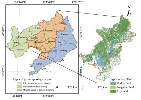
Fig.1 Location and farmland types in the Central Plain region of Liaoning Province
1.2 Data sources
Vector data in 2017 for land use at a spatial resolution of 30 m × 30 m,reclassified into seven categories(farmland,forestland,grassland,water area,wetland,construction land,and unutilized land),were obtained from the Data Center for Resources and Environmental Sciences,Chinese Academy of Sciences (RESDC)(http://www.resdc.cn).The spatial distribution of farmland quantity was summarized,and the landscape pattern index was analyzed using Fragstats 4.2,based on landuse data.Data in 2017 for farmland quality classification and farmland fertility,from which the related evaluation indices were extracted,were acquired from the Land Resource Department of Liaoning.Using a 10 km ×10 km spatial grid as the basic research unit,a total of 629 grid cells were separated in the study area,from which the aggregated or discrete spatial characteristics of FQQEC were uniformly extracted by calculating indicators and implementing the spatial autocorrelation analysis of FQQEC.
1.3 Data analysis
1.3.1 Indicator of farmland quantity
Farmland density,one of the basic quantitative characteristics of farmland quantity,refers to the ratio of farmland area to total land area in each grid unit.This can be calculated using Eq.1:
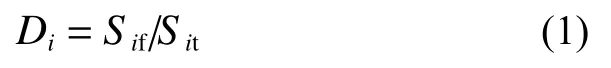
whereDdenotes farmland density in grid unit,Sdenotes farmland area,anddenotes the total land area.
1.3.2 Indicator of farmland quality
Quality classification integrates the differences in farmland natural quality,land use,and socio-economic level,and the impacts on land productivity in different regions,and has been widely recognized and applied in farmland quality evaluation and protection.Therefore,we selected the comprehensive score of farmland quality(CSFQ) to represent farmland quality and calculated this using the area-weighted average (Eq.2):

whereRis the comprehensive score of farmland quality in each grid unit andRandSdenote the comprehensive score and area for each farmland quality classification in each grid unit,respectively.
1.3.3 Indicator of farmland ecological conditions
As a highly coupled complex with economic,social,and natural values,farmland also has important landscape ecological characteristics.Farmland landscape ecological security indexe (FLESI) value reflects the fragility of farmland and the fragmentation of landscape types and boundaries.Spatial agglomeration characteristics indicate the hypothetical impact on farmland safety.From the perspective of landscape research,FLESI has been used as a synthetic indicator of farmland ecological conditions in other studies (Huang et al.,2007).The formula for FLESI is given in Eq.9:

where AWMSI is the area-weighted mean shape index,FRAC is the fractal dimension,DIVISION is the landscape division index,is the number of farmland patches,Pis the perimeter of farmland patchAis the area of farmland patchandrepresents the landscape vulnerability index.In accordance with the analytic hierarchy process,Yu et al.(2018) set α at 0.59,at 0.28,andat 0.13FLESI is the farmland landscape ecological security index,PD and ED are the patch density and edge density,respectively,and 2.5 is the reduction coefficient.
1.3.4 Spatial autocorrelation analysis
Global and local spatial autocorrelations are the two main types of spatial autocorrelation in relation to regression analysis.Anselin (2010) proposed local Moran’s,with values ranging from —1 to +1,as a measure of local spatial autocorrelation,where a value approaching +1 and —1 indicate spatial clustering and spatial dispersion,respectively.
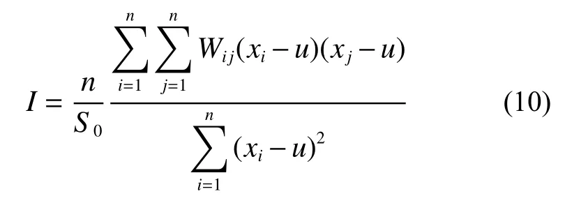
Global spatial autocorrelation analysis was used to assess the spatial distribution of attribute values throughout the study area and to apply an overall value.The commonly used statistic is Moran’sindex,as shown in Eq.10:
Given that global spatial autocorrelation cannot specifically indicate the spatial position of aggregation,it must be supported by local spatial autocorrelation.The latter can be used to calculate an index for each spatial unit to measure the relationship between two adjacent units.The specific formula is shown in Eq.11:

where,xandxare the attribute values of unitand unit,respectively;is the average value;is the number of samples; andWis the weight of the evaluation unit.
1.3.5 Trinity protection zoning of farmland
The protection zoning pattern of FTP was constructed with space overlapping analysis of high-high (H-H),low-low (L-L),and non-significantly correlated areas of farmland quality,quantity,and ecological conditions(FQQEC) using the spatial analysis functions of GIS.The farmland resources in the central plain area were divided into four primary category areas and ten secondary category areas.The primary categories were key protection,active protection,general protection,and regulatory protection.The key protection zone is a group of H and non-significant types of FQQEC; the active protection zone is a combination of H,L,and non-significant types of FQQEC; the general protection zone consists of L and non-significant types of FQQEC; and the regulatory protection zone comprises the non-significant type of FQQEC.
2 Results
2.1 FQQEC distribution characteristics analysis
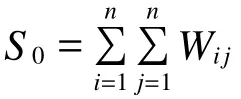
Farmland density is a basic indicator of farmland quantity.A high density is indicative of a high concentration of farmland in each grid unit.Using the natural breakpoint method for the values calculated based on Eq.1 with Geographic Information Systems (GIS) software,the farmland density of each grid unit in the Central Plains of Liaoning was divided into five levels.These levels with farmland densities of 0—0.16,0.16—0.35,0.35—0.51,0.51—0.64,and 0.64—1.00,accounted for 14.1%,19.9%,15.2%,22.9%,and 22.9% of the total farmland area,respectively.Of the farmland area,45.9%exceeded a density of 0.51,which was higher than the average farmland density (0.31) of the total.Fig.2a indicates that high-density farmland was concentrated in the central and northwestern areas,which are also the main grain production areas in northeast China.The characteristics of farmland quantity distribution are primarily influenced by topographical conditions,as the southeast region is adjacent to mountainous terrain.The farmland fields in this area are relatively fragmented and the cultivation of this type of farmland may result in high farming costs,which may increase the risk of abandonment.
The CSFQ reflects the natural conditions of farmland and its economic utilization.The higher the CSFQ,the higher are the natural conditions and utilization levels,and the better is the development of the regional agricultural economy.Fig.2b presents CSFQ data calculated using the farmland area weighting method for each grid unit,in which different indices of farmland quality classification were acquired.The values calculated using Eq.2 revealed that the CSFQ was divided into five levels(0.00—229.11,229.11—527.99,527.99—712.31,712.31—930.11,and 930.11—1000.0,covering 1.4%,28.8%,28.9%,31.7%,and 9.3% of the total farmland area,respectively).These findings thus indicate that 69.8% of the farmland has an above average quality (CSFQ:520.0).In total,most of the farmland in the Central Plain of Liaoning is of good or medium quality,although there is no other farmland with a high quality (a CSFQ value greater than 1000.0),which can be attributed to the soil and climatic conditions of Northeast China.The quality of farmland in the central area was significantly higher than that in other areas,which are located adjacent to the low hilly area on the western side and mountainous terrain on the eastern side.Notably,the areas of higher farmland quality coincide with the areas of higher farmland density.
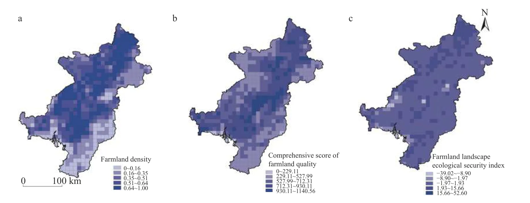
Fig.2 Classification map of farmland density (a),quality (b),and ecological conditions (c) of the Central Plain region of Liaoning Province
The values obtained for the indicator of farmland landscape ecological security (FLESI),calculated using Fragstats 4.2 at a scale of 10 km × 10 km,were as follows: below —5.9,—5.9 to —1.07,—1.07 to 1.33,1.33 to 10.66,and above 10.66,accounting for 2.3%,5.0%,58.2%,34.4%,and 7.5% of the total farmland area,respectively.Fig.2c shows that the FLESI areas with high(>10.66; 7.5% of area) and low (<—1.07; 7.3% of area)values are scattered around two medium (—1.07 to 10.66;92.5% coverage) value areas.Overall,FLESI values were found to be closely associated with the geomorphic conditions and landscape types; i.e.,high FLESI values in the south of the region characterized by low slopes(slope <5°) on flat areas,and in the northwest with fertile landscape types (e.g.,farmland,forest,and grassland).
2.2 FQQEC spatial autocorrelation analysis
The data presented in Fig.3 show that the spatial agglomeration of farmland quantity was at a higher level in the largest high-density areas,indicating the high benefits of agricultural use,and accordingly a higher need for farmland protection and utilization.The data presented in Table 1 indicate that the areas with a positive correlation type covered nearly 3.0 million hmcharacterized by “patch” and “ribbon” type distribution patterns,and accounted for 55.8% of the total farmland area in the Central Plains of Liaoning.The H (high value of quality)-H-type area,representing farmland of the spatial unit per se and the surrounding area,was found to be the predominant type,covering 1.9 million hmand accounting for 36.2% of the total farmland in the central regions.The L(low value of quality)-L-type area,indicative of lowdensity farmland of the spatial unit and surrounding area,is mainly distributed in southern regions with a typical ribbon pattern and cover 1.0 million hm,accounting for only 19.5% of the total farmland area.The H-L and L-H type areas,representing an alternative distribution of high and low density farmland,covers 20.0 thousand and 30.0 thousand hm,accounting for 0.4% and 0.6% of the total farmland area,respectively.Non-significant correlation areas,covering 2.3 million hm,accounted for 43.3% of the total farmland area,and lacked spatial features in grid units around the plain area such as H-H-type or L-L-type area in which the internal high density and low density areas were mutually staggered.
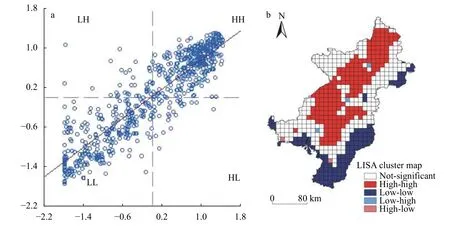
Fig.3 Moran’s I scatter plot (a) and local spatial agglomeration map (b) of farmland quantity of the Central Plain region of Liaoning Province .High (H) and Low (L) respectively represent the high and low value of farmland quantity in panels (a) and (b)

Table 1 LISA cluster areas of farmland quantity,quality,and ecological conditions km2 (% of total area)
Fig.4 shows that the spatial agglomeration of farmland quality is similar to that of farmland quantity,and is distributed in a “patch” and “ribbon” pattern with highly positive correlation types.H-H-type areas cover 1.3 million hmor 24.2% of the total farmland area in the central areas of the Central Plains of Liaoning,wherein it is distributed continuously and widely.L-L-type areas cover 0.7 million hm,accounting for 12.9% of total farmland area,and are bordered by hilly areas,characterized by agriculturally poor environmental conditions (e.g.,qualities of water,soil,and climate),thereby limiting cultivation and shifting the quality farmland to lower levels.The areas of H-L-type and L-H-type farmland quality,representing the heterogeneous distribution of high and low quality farmland,cover 22.6 thousand and 58.2 thousand hm,and account for 0.4% and 1.1% of the total farmland area,respectively.Non-significant correlation areas,close to the H-H-type areas,cover 3.3 million hmor 61.4% of the total farmland area.The areas of high and low quality farmland are irregularly distributed and have no significantly distinct dominant features,although have certain potential for improvement when compared with the characteristics of H-H-type farmland in some areas.
Fig.4 Moran’s I scatter plot (a) and local spatial agglomeration map (b) of farmland quality of the Central Plain region of Liaoning Province.High (H) and Low (L) respectively represent the high and low value of farmland quality in panels (a) and (b)
The data presented in Fig.5 indicate that the spatial agglomeration of FLESI was at a lower level than that of the other indicators.Farmland areas with positive correlation cover only 1.1 million hmwith a scattered or cluster distribution,and account for 21.3% of the total farmland area in the Central Plains of Liaoning.The H-Htype area,covering 0.5 million hm,accounts for 21.3%of the total farmland area,and is scattered within a high ecological security area with flat and concentrated farmland and diverse vegetation.The L-L-type area,which covers 0.6 million hmand accounts for 11.6% of total farmland area,is predominantly distributed in the north and northwestern regions characterized by fragmented farmland landscapes and arid to semi-arid climatic conditions.The H-L-type and L-H-type areas amount to 68.2 thousand and 37.3 thousand hm,accounting for 1.3%and 0.7% of the total farmland area,respectively.Notably,however,the coverage of non-significant correlation areas is nearly 4.1 million hmin size,accounting for 76.7% of the total farmland area,which reflects the instability of landscape ecological security; i.e.,these areas coincide with the intersection of landscape ecological safety and fragile zones (Fig.5).
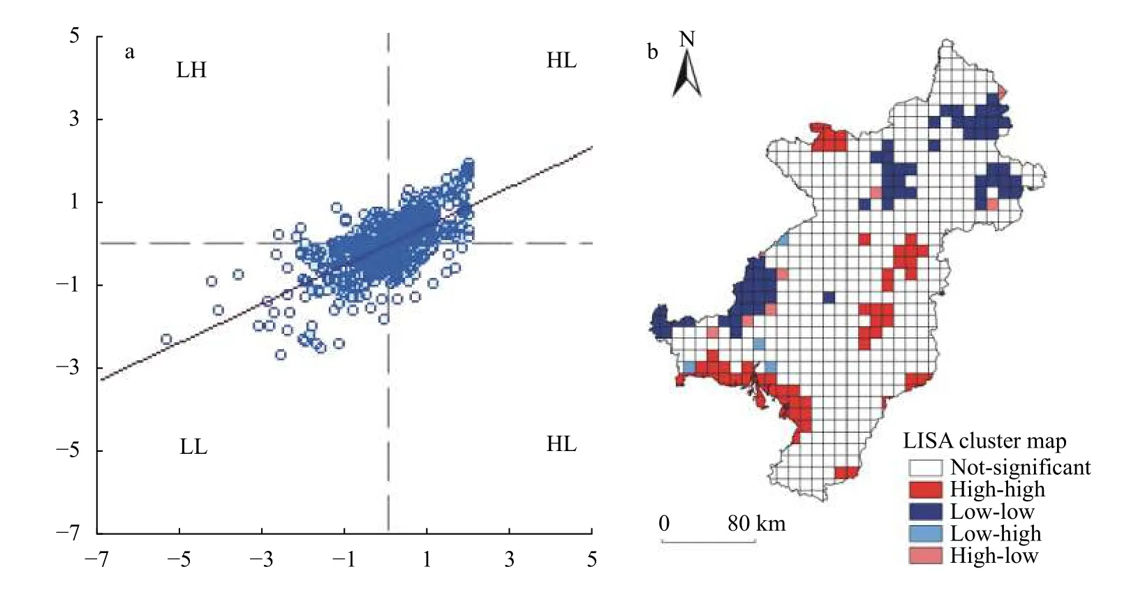
Fig.5 Moran’s I scatter plot (a) and local spatial agglomeration map (b) of the farmland ecological security index of the Central Plain region of Liaoning Province.High (H) and Low (L) respectively represent the high and low value of the farmland ecological security index in panels (a) and (b)
2.3 Trinity protection zoning analysis
On the basis of the results obtained from spatial autocorrelation analysis of FQQEC in the Central Plain of Liaoning Province,an overlay analysis of the local spatial autocorrelation types of FQQEC was conducted.The findings of this analysis indicated that each grid represented a combination of different aggregation types of the three attributes FQQEC.Furthermore,using different permutations and combinations of H,L,and non-significant types,the farmland resources in the central plain area were grouped into four primary categories,namely,key,active,general,and regulatory protection areas (Fig.6a,Table 2),and 10 secondary category areas (Fig.6b,Table 2).
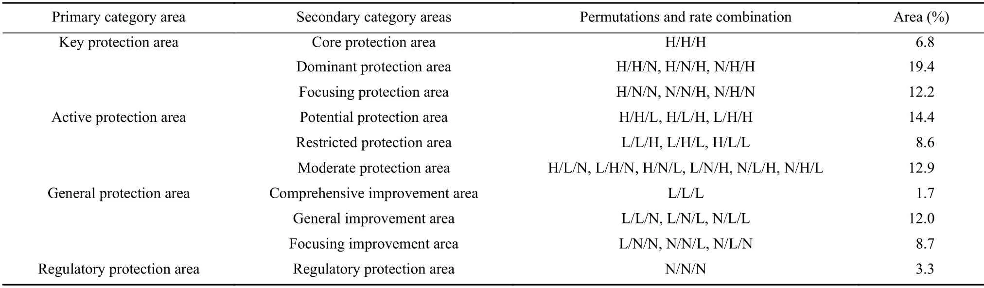
Table 2 Farmland protection zoning based on local spatial autocorrelation of farmland quantity,quality,and ecological conditions in the Central Plain of Liaoning Province
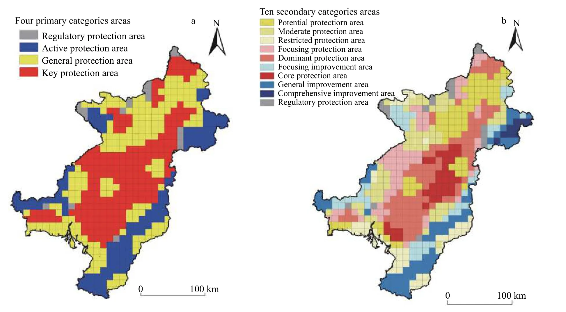
Fig.6 Farmland protection zoning according to primary (a) and secondary (b) area categories in the Central Plain of Liaoning Province
The key protection area consisted of at least one H type and one non-significant type of FQQEC,covering 38.4% of the total farmland area,which was concentrated in the central part of the research area,and was characterized by a strong spatial agglomeration effect.On the basis of the different combinations of H and nonsignificant types with respect to agglomeration,the key protected areas were divided into the following three secondary protection areas: a core protection area with three H types (6.8% coverage),a dominant protection area with two H types (19.4% coverage),and a focused protection area with only a single H type (12.2% coverage).
The combination of H,L,and non-significant types were classified into active protection zones covering 35.9% of the total farmland area,distributed at the periphery of the core protection area.Given the uncertain combination of H,L,and non-significant types,the active protection areas were divided into the following three secondary protection areas: a potential protection area with two types of H type and one L type (14.4% coverage),a restricted protection area with two L types and one H type (8.6% coverage),and a moderate protection area with a combination of H,L,and non-significant types (12.9% coverage).
The general protection area consisted of at least one L type and one non-significant type of farmland quantity and quality,and ecological conditions,accounting for 22.4% of the total farmland area.This class of protection area was distributed along the eastern and western edges of the central plain,which have certain limitations with respect to farmland utilization and protection.
On the basis of different combinations of L and nonsignificant types with regards to agglomeration,the general protection area was divided into the following three secondary protection areas: a comprehensive improvement area with three L types (1.7% coverage),a general improvement area with two L types (12.0% coverage),and a focusing improvement area with only a single L type (8.7% coverage).
The regulatory protection area consisted of only nonsignificant types of FQQEC.It accounted for 3.3% of the total farmland area scattered in the northwestern region of the central plain,with large differences in farmland utilization and no secondary protection area division.
3 Discussion
3.1 FQQEC differences among spatial agglomerations
The area covered by the H-H-type farmland quantity (36.2%) was larger than that of both farmland quality (24.2%),and ecological conditions (9.7%).These differences indicate that farmlands of better quality are large and predominated across contiguous areas with high density.In terms of quality,the area of H-H-type farmland was 12.0% less compared with that of farmland quantity.It tended to be concentrated in the core area of farmland quantity,and is considered indicative of farmland with better quality.Superior soil conditions,convenient infrastructure,and high-level input and management have contributed to large-scale agricultural development patterns in these areas.Compared with farmland quantity and quality,the H-H-type area of farmland ecological conditions was smaller by 26.5% and 14.5%,respectively,and scattered around the H-H-type area of FQQEC.These values thus highlight the ecological fragility and non-significant dominant characteristics of farmland ecological conditions.
The L-L-type areas of FQQEC accounted for only 19.5%,12.9%,and 11.6% of the total farmland area,respectively.These areas were distributed on the periphery of the Central Plains of Liaoning,and characterized by a low density (<0.16),poor quality (<327.69),and fragile ecological conditions (<—1.01).Given the limiting factors associated with the L-L areas,which would be difficult to address in the future,these areas are identified as being generally unsuitable for farmland utilization.The areas H-L-type and L-H-type FQQEC were essentially insignificant,with each type accounting for less than 1.5% of the total farmland.Given their distribution patterns,the farmland of these two types is readily influenced by the dominant characteristics of H or L type transformation with efficient land utilization.
Non-significant types should be given more attention on account of their disordered distribution of H and L types with the largest areas.The non-significant type areas of FQQEC accounted for 43.3%,61.4%,and 76.7%,respectively.With appropriate managerial interventions (e.g.,land consolidation,high-standard farmland construction,and ecological renovation),these land types may have high potential for conversion to the H-Htype.Otherwise,these lands could also be converted to other usage types.
3.2 Farmland protection and utilization measures
Within the key protection area,the H type had a particular suitability for FQQEC,which could be closely associated with a spatial agglomeration effect relative to the non-significant type in farmland utilization and protection.Therefore,aiming at spatial agglomeration advantages of the H type in the secondary category areas,the core protection area is characterized by prime farmland conditions with no limitations and should be preferentially designated as high-standard farmland and permanent basic farmland protection areas.The dominant protection area with two types of H,which also has a distinct agglomeration effect,should be improved by converting from the non-significant to H type,and be actively protected as basic farmland area.In terms of spatial agglomeration,the focused protection area has only a single H type advantage.
The active protection zone comprises a combination of H,L,and non-significant types that show different spatial characteristics.The potential protection area could be most readily improved to attain the advantages of the other two H types via farmland capital construction (e.g.,farmland leveling,irrigation,and water conservation).The restricted protection area,which is mainly located on the periphery of the central plain adjacent to hilly areas,presents greater difficulties with respect to farmland utilization and improvement.Hence,two L type clustering attributes should be promoted on the basis of the clustering results and protection of its dominant attributes.In the moderate protection area,the non-significant type should be accorded greater attention,given that it is readily influenced by H type or L type areas,and amenable to conversion to other types.In this regard,an effective approach would be to preferentially protect the H type dominant attributes and exploit external advantages to influence the non-significant attributes.
The general protection area,characterized by poor spatial agglomeration of the L type,was divided into comprehensive improvement,general improvement,and focused improvement areas.The comprehensive improvement area,with no advantages,would be the most difficult to remediate,and is thus considered to be unsuitable for use as farmland and should be utilized for construction purposes.In the general improvement and focused improvement areas,the non-significant type should be managed and protected effectively with appropriate measures,and transition to active protection zones with at least one H type should be promoted.
The regulatory protection area,which is primarily located in the central zone between key and general protection areas,is characterized by uneven distribution of L and H types,which has given rise to a non-significanttype area.Therefore,it is vulnerable to the influence of surrounding areas,and may develop into H type or L type areas with discrete spatial characteristics.These areas can be modified and optimized with respect to agricultural structures and should be accorded particular attention with regards to their comparative advantages and the extent of spatial agglomeration with other areas of H type characteristic.
3.3 Research deficiencies and prospects
The trinity protection of FQQEC is an innovation theory in China that is of considerable significance from the perspectives of guiding the practical aspect of newera farmland protection,constructing new patterns,and promoting the sustainable utilization of farmland resources.In addition,FTP is a systematic hierarchical concept that emphasizes that farmland quantity protection is the basis for farmland quality protection,which in turn contributes to guaranteeing farmland quantity protection,whereas farmland ecological protection provides a basis for protecting both farmland quantity and quality.
The protection of farmland quantity entails ensuring and meeting the needs of regional population viability at different scales.On the basis of the findings of the present study,we believe it is essential to extend the red line of protection afforded to high-density and H type farmland in the Central Plain of Liaoning.Furthermore,assessment of the requisition-compensation balance is considered the most effective and stringent measure of the total dynamic balance of farmland quantity and quality,whereas protection zoning based on the difference in FTP can effectively prevent the encroachment of prime farmland and supplement large areas of inferior farmland.
Soil conditions and infrastructure constructions are highlighted as the primary criteria for guaranteeing high farmland quality.In the low-quality farmland and L type areas,land consolidation and high-standard farmland construction may be the best strategies for improving farmland quality.This is particularly the case in key and active protection areas based on key soil characteristics(e.g.,depth,organic matter content,and texture),infrastructure conditions (e.g.,irrigation and transport facilities),soil limitations (salinization and acidification),and anthropogenic interventions (e.g.,land leveling,soil improvement,and water drainage).
Ecological protection contributes to maintaining the ecological balance and health of farmland,thereby ensuring sustainable utilization,promoting the ecological and landscape functions of farmland,and protecting farmland against pollution and degradation.
Spatial agglomeration analysis of ecological conditions indicated that nearly 76.7% of the non-significant correlation areas of farmland in the Central Plain of Liaoning are in need of intervention by the local government.Policy interventions are necessary to promote the construction of ecological farmland,the adoption of sustainable agriculture systems based on crop rotation and fallowing systems,and payments for the provisioning of ecosystem services (Kong,2014).In addition,the area of non-agricultural habitat that plays important ecological roles could be appropriately increased to enhance the quality of the ecological environment and increase species diversity.
4 Conclusions
With regards to our stated research hypothesis,the findings of this study have indicated that the spatially agglomerated distribution of FQQEC is characterized by distinctly correlated relationships among H-H,L-L,H-L,L-H,and non-significant types.Moreover,determining the zoning pattern of the FTP is an effective and practical approach for implementing FTP theory.In terms of the multi-level farmland protection zones,appropriate measures are proposed for farmland utilization and protection based on the distribution characteristics of FQQEC.
The data obtained in this study support the following conclusions:
1) The spatial agglomeration of H-H farmland quantity and quality was at a high level (36.2% and 24.2%,respectively),characterized by a “patch” and“ribbon” pattern of distribution in the central areas with the highest density and best quality of farmland.The farmland ecological conditions showed a lower spatial agglomeration with only 9.7% H-H-type that is scattered around the ecologically fragile central areas.
2) The spatial agglomeration of L-L farmland quantity (19.5%),quality (12.9%),and ecological conditions(11.6%) showed a similar distribution on the periphery of the central areas.Thus,it is essential to reduce the impact of the L-L-type through farmland engineering measures or transformation to rational land utilization.However,attention should also focus to the non-significant correlation areas,given their large size (43.3%,61.4%,and 76.7%,respectively),in which the H and L types showed uneven distribution and discrete spatial characteristics.It is recommended that attention should be given to the comparative advantages and the extent of spatial agglomeration with other H type areas.
3) With regards to different permutations and combinations of H,L,and non-significant types,as revealed by GIS,the study areas were grouped into four primary category areas (key,active,general,and regulatory protection areas),which were further sub-divided into 10 secondary categories.Key protection areas should be preferentially designated as a high-standard farmland areas and a permanent basic type of farmland protection area.Wherever possible,land consolidation engineering should be used in active protection areas to enhance H type effects.Given that in terms of alleviation,the general protection area was characterized as having the most pronounced constraints,and attention should focus on the detrimental influence of the L type and on promoting rational land use.In regulatory protection areas,it is considered possible to strengthen H type influences with corresponding measures and promote the conversion to key protection area status.
4) The farmland trinity protection of quantity,quality,and ecological conditions represents an innovative theory in China’s farmland protection history.Moreover,it is a systematic hierarchical concept.Research perspectives on FTP at different spatial and temporal scales that encompass multi-disciplinary theories and knowledge,will undoubtedly be broader and more diverse.