
Seismic imaging of the double seismic zone in the subducting slab in Northern Chile
2021-10-28 11:38:12PnLuHijingZhngLeiGoDinComte
Earthquake Research Advances 2021年1期
Pn Lu ,Hijing Zhng,* ,Lei Go ,Din Comte
a Laboratory of Seismology and Physics of Earth's Interior,School of Earth and Space Sciences,University of Science and Technology of China,Hefei,Anhui,230026,China
b Departamento de Geofísica,Advanced Mining Technology Center,Facultad de Ciencias Físicas y Matem′aticas,Universidad de Chile,Blanco Encalada,2002,Santiago,Chile
Keywords:Chile subduction Zone Double difference seismic tomography Double seismic zone Dehydration embrittlement
ABSTRAC T Double seismic zones are commonly observed in the subducting slabs in a global scale,serving as ideal examples for studying the seismogenetic mechanism of the intermediate-depth earthquakes.In this study,we relocate earthquakes and determine seismic velocity models using the double-difference seismic tomography method in the northern Chile subduction zone where a double seismic zone exists.The results suggest that the double seismic zone in northern Chile is located at about 50-140 km depth,with an interval of approximately 20 km between the two zones.The upper seismic zone is characterized by relatively low Vp (~7.8-8.0 km/s),low Vs(~4.4-4.5 km/s) and high Vp/Vs (~1.85) above the depth of~90 km,while the region below~90 km is distinguished by relatively high Vp (~8.2 km/s),high Vs (~4.8 km/s) and slightly high Vp/Vs (~1.75),which may be related to a series of dehydration reactions of hydrous minerals in the subducted oceanic crust.In comparison,the lower seismic zone is featured by the anomaly of low Vp/Vs (~1.7),although some local areas may consist of relatively high Vp/Vs values(~1.8),possibly due to the dehydration reaction of serpentine.Based on the Vp,Vs,Vp/Vs anomalies combined with previous petrological experiments and thermodynamic models,it can be derived that intermediate-depth earthquakes are mainly related to the dehydration of various hydrous minerals in the subducting slab.The dehydration process of hydrous minerals releases water into the subducting slab and subsequently leads to the increase of pore fluid pressure and the decrease of effective normal stress,thus causing the occurrence of brittle failure and intermediate-depth earthquakes in subduction zones.The imaging results of the northern Chile subduction zone further indicate that the existence of the double seismic zone is related to the dehydration process of different hydrous minerals.
1.Introduction
Since the discovery of the double seismic zone in Tohoku(Hasegawa et al.,1978a,b),numerous subduction zones around the world have been investigated,and several double seismic zones have been detected in some of them,such as Alaska (Abers,1992,1996),Northern Chile(Comte and Suarez,1994;Comte et al.,1999),Kuril(Kao and Liu,1995),Kamchatka (Gorbatov et al.,1994),New Zealand (Mcguire and Wiens,1995),Tonga (Kawakatsu,1986),and Cascadia (Cassidy and Waldhauser,2003).Brudzinski et al.(2007) investigate a number of subduction zones worldwide and suggest that the separation distance between the upper and lower planes of seismicity varies from~8 km for an~12 Ma slab to~30 km for an~160 Ma slab,and is proportional to the age of the subducting plate.
The investigation of double seismic zones may provide us new insights for constraining seismogenesis in subduction zones to explain the two layers of earthquakes and their separation features.Generally,the occurrence of an earthquake requires two conditions,one is the shear stress that can produce shear deformation,and the other is a mechanism that can store and release strain.The stress states of double seismic zones are basically characterized by down-dip compression and tension along the upper and lower seismic layers,respectively.Several mechanisms have been proposed to explain the stress conditions in double seismic zones,including unbending of the slab (Isacks and Barazangi,1977;Kawakatsu,1986),thermoelastic stress(Fujita and Kanamori,1981;Goto et al.,1985) and sagging of the plate (Sleep,1979).Furthermore,both layers of the double seismic zone beneath Alaska(Abers,1992)and New Zealand (Robinson,1986) are featured by down-dip tension,while for those beneath Mexico (Pardo and Suarez,1995) and northern Chile(Comte and Sua'rez,1994),the upper and lower zones are respectively characterized by down-dip tension and down-dip compression,which cannot be explained by each of the three mechanisms above.
Dehydration-related embrittlement of different hydrous minerals in subducted plates is thought to be a promising hypothesis for generating intermediate depth events(Green and Houston,1995;Kirby et al.,1996;Seno and Yamanaka,1996).The upper plane of double seismic zones occurs mainly in the oceanic crust of subducted plates and is possibly caused by the dehydration of metamorphosed basalts and gabbro,which may be transformed to eclogite(Kirby et al.,1996).By contrast,the lower plane is mainly located in the mantle of the subducted plate and is probably induced by the dehydration of serpentine (Peacock,2001) or other hydrous minerals(Omori et al.,2002;Hacker et al.,2003b).With the subduction of the plate,hydrous minerals that originally exist in the lithosphere before subduction go through various dehyration reactions and release water,lowering the effective normal stress and thereby enabling embrittlement that may result in earthquakes.Based on experimentally and theoretically derived phase diagrams of the hydrous minerals that compose the oceanic crust and mantle,Hacker et al.(2003a,b) found that the depth ranges of hydrous minerals and intermediate depth earthquakes are consistent within the slabs beneath Cascadia,Costa Rica and NE and SW Japan.Furthermore,Yamasaki and Seno(2003) indicate that intermediate-depth intraslab events tend to concentrate along the dehydration reaction boundaries within slabs.Abers et al.(2013) estimate the amount of released water and production rate from dehydration reactions,which are consistent with the amount of intermediate-depth earthquakes.In addition,numerous studies have shown that intermediate-depth earthquakes in subducted plates are related to the dehydration reaction of hydrous minerals within the plates(Raleigh and Paterson,1965;Silver et al.,1995;Peacock and Wang,1999;Peacock,2001;Dobson et al.,2002;Green and Marone,2002).Brudzinski et al.(2007) conclude that the occurrence of double seismic zones is more likely due to the dehydration phase transformation of antigorite rather than chlorite.
It is well acknowledged that a double seismic zone also exists in the subducting Nazca plate beneath northern Chile.In this area,the 50 Ma Nazca plate (Cande and Haxby,1991) is subducting beneath the South American plate at a rate of 8.4 cm/yr (DeMets et al.,1990).Comte and Suarez (1994) suggest that a double seismic zone may exist around Iquique and Antofagasta in northern Chile through the analysis of earthquake focal mechanisms.Comte et al.(1999),Rietbrock and Waldhauser (2004) successively discover the existence of a double seismic zone near Arica and 22°S in northern Chile.Based on the phase diagrams of hydrous minerals,Yamasaki and Seno (2003) find that in northern Chile the depth range of dehydration reactions in oceanic crust is consistent with upper seismic zone and serpentine dehydration occurs in the region where lower seismic zone is located.
Seismic velocity is highly sensitive to water distribution,serpentinization and partial melting (Christensen,2004;Ji et al.,2013).Zhang et al.(2004) study the double seismic zone in northern Honshu,Japan using the double difference seismic imaging method tomoDD(Zhang and Thurber,2003),and provide high resolution imaging constraints for the dehydration of hydrous minerals involved in the double seismic zone.They also observe clear velocity anomalies in both the upper and lower seismic zones compared with the surrounding areas.Shelly et al.(2006)investigate the subduction zone of Ibaraki Prefecture,Japan by tomoDD,and obtain a similar phenomenon.In addition,different types of seismic imaging studies have been conducted by different researchers,including the deep reflection profile (ANCORP Working Group,1999;Yoon et al.,2009),receiver functions (Yuan et al.,2000),body wave travel-time tomography (Dorbath et al.,2008) and joint inversion of body and surface waves (Comte et al.,2016),etc.These studies have discussed the effect of hydrous minerals on intermediate-depth earthquakes,however,the seismogenic mechanisms for the double seismic zone in northern Chile a not well addressed.
This paper applies the tomoDD method to Pisagua region(19°-20°S)in northern Chile to obtain high resolutionVp,Vs andVp/Vs models in this region.The mechanism of the intermediate-depth double seismic zone in this region will be discussed based on the combination of seismic velocity models,prevois petrological experiement results,and mineral phase diagrams.
2.Data and method
We collect P-and S-wave data of 9832 earthquakes recorded by 244 short-period stations in the study area from 1990 to 2013 (Fig.1;Comte et al.,2016) and obtain 89 315 absolute travel times of P-wave and 85 790 absolute travel times of S-wave.As can be seen from the travel-time curves of P and S waves,the quality of data is relatively high(Fig.2).According to these data,we construct differential travel times for event pairs that will be used for double-difference tomography.It is required that the interval between event pairs should be within the range of 5-30 km and the maximum distance between events and stations should be no more than 800 km.Finally,1 483 813 P-wave differential travel times and 1 365 567 S-wave differential travel times are obtained.The absolute and relative travel times add up to a total of 3 024 485,with the average spacing between event pairs being approximately 19 km.
In this study,a regional scale version of double-difference tomography algorithm (tomoDD) is adopted (Zhang and Thurber,2006).The algorithm is adapted from the small-scale version of tomoDD (Zhang and Thurber,2003).It can use both the absolute data and differential travel time data to simultaneously invert for the 3-D velocity structure and seismic locations in the target region.The main advantage of the algo-rithm is that the differential data can be used to improve the model resolution in the source region.The region-scale tomoDD adopts pseudo-bending ray tracing algorithm in spherical coordinates(Um and Thurber,1987) to calculate the ray paths between earthquakes and stations as well as the travel time of P and S waves based on the current velocity models.In order to control large data residuals,residual weighting strategy is used in the inversion to reduce the impact of large residuals (Waldhauser and Ellsworth,2000).LSQR algorithm (Paige and Saunders,1982) is used in tomoDD;furthermore,smoothing and damping regularizations are added into the inversion system.
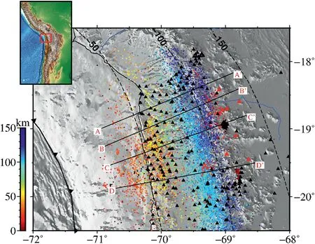
Fig.1.Map view of the study area.The black line with the black triangle indicates the location of the trench;Colored dots represent earthquakes,and different colors show their depths;The black triangle represents the station;The red triangle shows the distribution of volcanoes;The marked black line segment indicates the position of the cross sections.The red boxe in the inset map indicates the location of the study area.(For interpretation of the references to color in this figure legend,the reader is referred to the Web version of this article.)
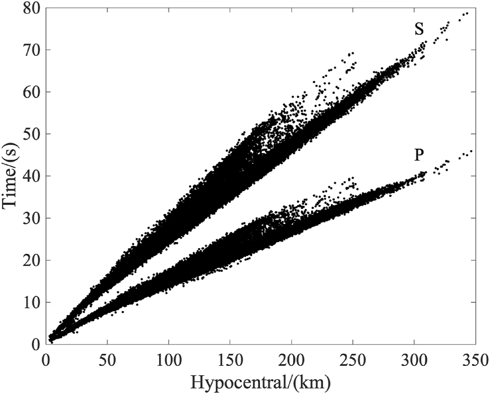
Fig.2.Time-distance curves of P-and S-wave travel times.
For the purpose of reliably determining the 3-DVp/Vs model of the study area,two strategies are adopted.One is to directly divideVp byVs velocity models.In the region with goodVp andVs resolutions,this strategy may give a reliableVp/Vs model,even though theVp/Vs values may contain some artifacts.The other strategy is to directly invertVp/Vs using S-P differential times based on the assumption that the ray paths of S and P waves are very close (Zhang et al.,2009).In this study,we use the extended tomoDD method to directly invert forVp/Vs based on theVp/Vs consistency constraint(Guo et al.,2018).
3.Inversion details and model resolution analysis

Fig.3.One-dimensional initial velocity models used in inversion.

Fig.4.Grid settings for the inversion.(a)The grid distribution in longitude and depth directions;(b) The grid distribution in latitude and depth directions.
Double-difference tomography algorithm is essentially based on linear inversion,so a reliable initial velocity model is necessary.Here,a one-dimensional initial velocity model(Comte et al.,2016)is selected as the initial model,as shown in Fig.3.The spacing of the inversion grid is 0.3°in the latitude direction,0.1°in the longitude direction,and 10 km in the depth direction (Fig.4).In the process of inversion,the velocity values on grid nodes are updated,and the velocity values between grid nodes are obtained by linear interpolation (Zhang and Thurber,2003).The damping and smoothing parameters used in the inversion are obtained through the trade-off analysis between the root mean square of the updated model values and that of the data residuals (Aster et al.,2013).We adopt a hierarchical weighting strategy,that is,in the initial stage of inversion,we first give more weight to the absolute data to obtain the large-scale velocity structure,and then gradually reduce the weight of the absolute data while increase the weight of the differential data,In this way,fine-scale velocity structures in the source region can be obtained.A total of 15 iterations are carried out in the whole inversion process,with two simultaneous seismic relocation and velocity tomography and one seismic relocation only performing alternately.The root mean square value of travel time residuals decreases from the 0.364 s-0.155 s after inversion.Fig.5 shows the comparison of histograms of travel time residuals of P-wave and S-wave before and after inversion.It can be seen that the travel time residuala of S-wave are larger than those of P-wave,because the picking accuracy of S wave arrival time is lower than that of P-wave in general.
In order to analyze the model resolution obtained from the inversion with the current data distribution,we further conduct synthetic tests,including the checkerboard test(Humphreys and Clayton,1988)and the restoration test forVp/Vs models (Zhao et al.,1992).For the checkerboard test,we add a velocity perturbation of ±5% to the adjacent grid nodes of the initial model,then calculate the travel times to obtain the synthetic data with the same distribution as the real data,and use the same inversion parameters to invert for the velocity models.Figs.6 and 7 show recovered checkerboard sections of P and S waves along latitudes 18.3°S,18.9°S,19.2°S,and 19.8°S.It can be seen from the test results that the resolution of the model is good in the seismogenic region and the region between events and stations due to the higher ray density.In the depth direction,the checkerboard resolution test shows that the inversion results display good resolution in the range of 20-120 km(Fig.8 and Fig.9).Fig.10 shows the restoration tests for theVp,Vs andVp/Vs models along section AA',where the Vp/Vs model is obtained by directly dividingVp byVs.The well recovered models from checkerboard and restoration tests indicate high resolution and reliability of our results.
4.Results
Fig.11,Fig.12,and Fig.13 show theVp,Vs,andVp/Vs models and relocated earthquakes along the four profiles perpendicular to the trench,respectively.The models are obtained by the direct division ofVp byVs.In order to further confirm the reliability of theVp/Vs model,we apply theVp/Vs consistency constraint double-difference tomography method(Guo et al.,2018) to directly invert forVp/Vs model (Fig.14).By comparing Figs.13 and 14,it can be seen that in the area with high resolution,except for some minor differences,the two models are generally similar.In addition,the main structural features can be well restored in the restoration test (Fig.10),which further verifies the reliability of ourVp/Vs model.The earthquakes in this region are mainly distributed along the plate interface and inside the slab,delineating the outline of the subduction zone.Moreover,the earthquakes are notably stratified,with the upper seismic zone extending from a depth of about 30 km to about 140 km,while the lower seismic zone starts at a depth of about 50 km and extends to a depth of about 140 km.The two seismic layers show significantly different distribution characteristics:the earthquake distribution from shallow to deep part of the upper seismic zone is relatively dense,while the lower seismic zone is characterized by sparse shallow earthquakes in the two northern sections and more earthquakes down to 100 km in depth.For the two southern sections,the earthquakes concentrate in 50-75 km.After 75 km,seismic events become relatively sparse and begin to appear more from~110 km to~140 km.In terms of velocity anomalies,the velocity results show that in the lower seismic zone,except for some areas with slightly higherVp/Vs anomalies (~1.80),there are relatively obvious lowVp anomalies(7.6-7.8 km/s),slightly higherVs (4.7-4.9 km/s),and lowVp/Vs anomalies (about 1.65-1.7).However,at 50-90 km depth in the upper seismic zone,the anomalous characteristics of lowVp (about 7.8-8.0 km/s),lowVs (about 4.4-4.5 km/s) and highVp/Vs (about 1.85-1.9)are obvious.However,at a depth of 90 km or deeper,Vp/Vs is around 1.76,andVp andVs become relatively high.These remarkable features have also been observed in other double seismic zones (Zhang et al.,2004;Nakajima et al.,2009).In addition,prominent lowVp,lowVs,and highVp/Vs anomalies also occur in the zones below volcanoes.
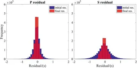
Fig.5.Comparison of P-and S-wave travel time residuals before and after inversion.

Fig.6.Checkerboard resolution test results for Vp along different latitudes.The black dots represent earthquakes.
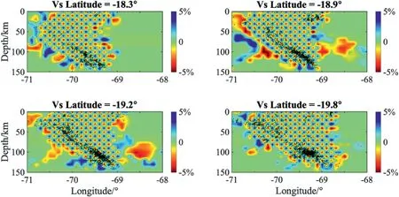
Fig.7.Checkerboard resolution test results for Vs along different latitudes.The black dots represent earthquakes.
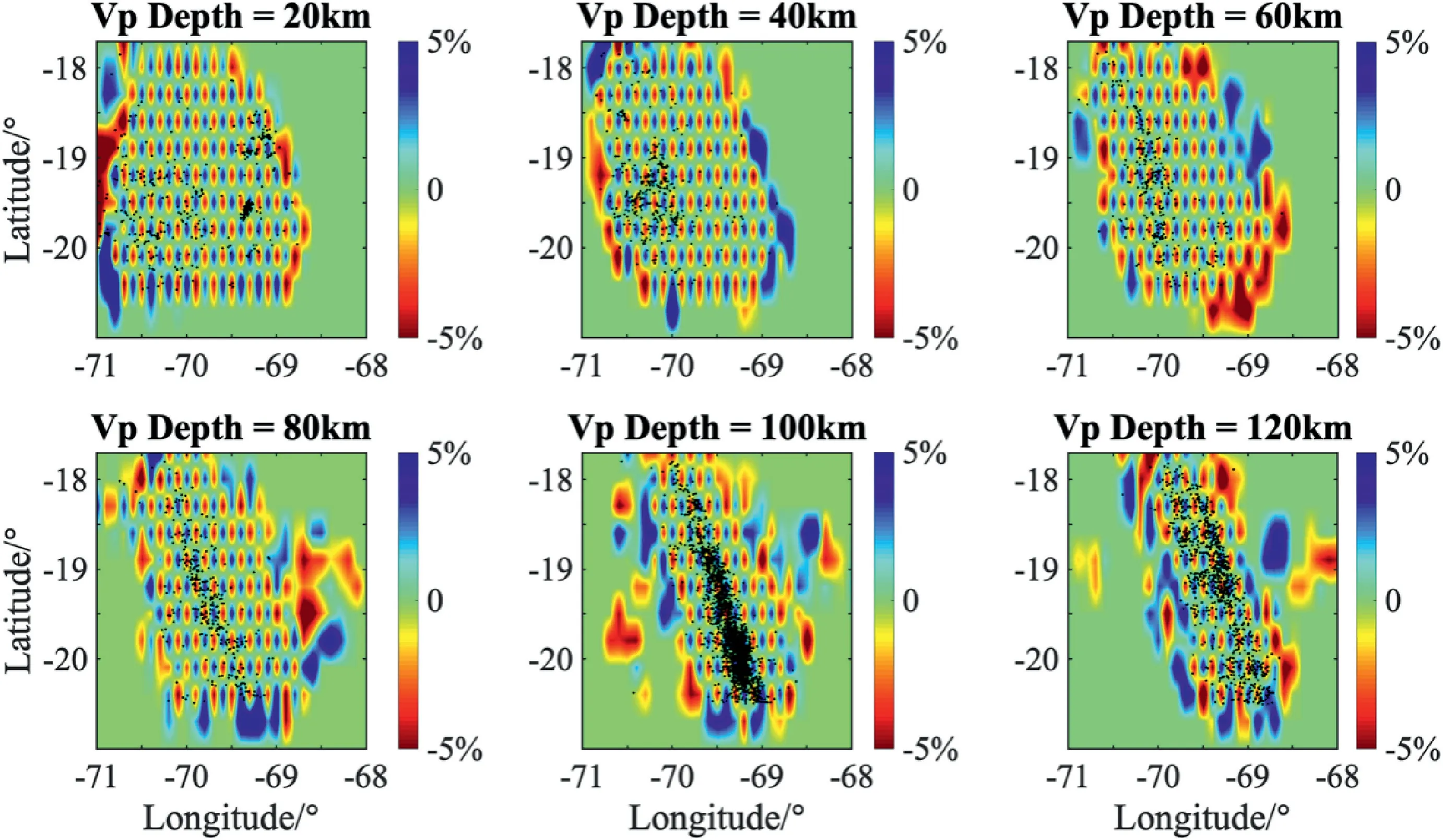
Fig.8.Checkerboard resolution test results for Vp at different depths.The black dots represent earthquakes.

Fig.9.Checkerboard resolution test results for Vs at different depths.The black dots represent earthquakes.
5.Discussion
5.1.Upper plane of the double seismic zone
As shown in Figs.11-13,the upper seismic zone presents lowVp(about 7.8-8.0 km/s),lowVs (about 4.4-4.5 km/s) and highVp/Vs(about 1.85)at a shallow depth of about 90 km.Such results are similar to those obtained by seismic tomography studies in other subduction zones(Zhang et al.,2004;Abers et al.,2009;Eberhart-Phillips and Bannister,2015;Rondenay et al.,2008;Syracuse et al.,2008),that is,the upper plane of the double seismic zone is usually distributed in the oceanic crust of the subducted plate.The average composition of the oceanic crust includes~7 km thick metamorphic basalt and gabbro with an average water content varying from 1 wt% to 6 wt% (Peacock,1993),which is usually characterized by low velocity anomaly relative to surrounding mantle rocks.These low-velocity anomalies in the subducted oceanic crust have thus become direct evidence for the presence and dehydration of hydrous minerals (Hasegawa and Nakajima,2017).Furthermore,highVp/Vs anomalies may be caused by the release of water from dehydration reactions of hydrous minerals.
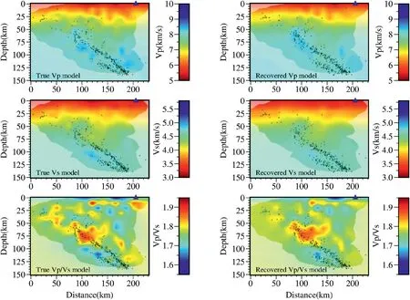
Fig.10.Restoration tests for Vp,Vs and Vp/Vs models along the AA'profile.The location of the profile is shown in Fig.1,with blue triangles indicating the location of the volcano and black dots representing earthquakes.(For interpretation of the references to color in this figure legend,the reader is referred to the Web version of this article.)
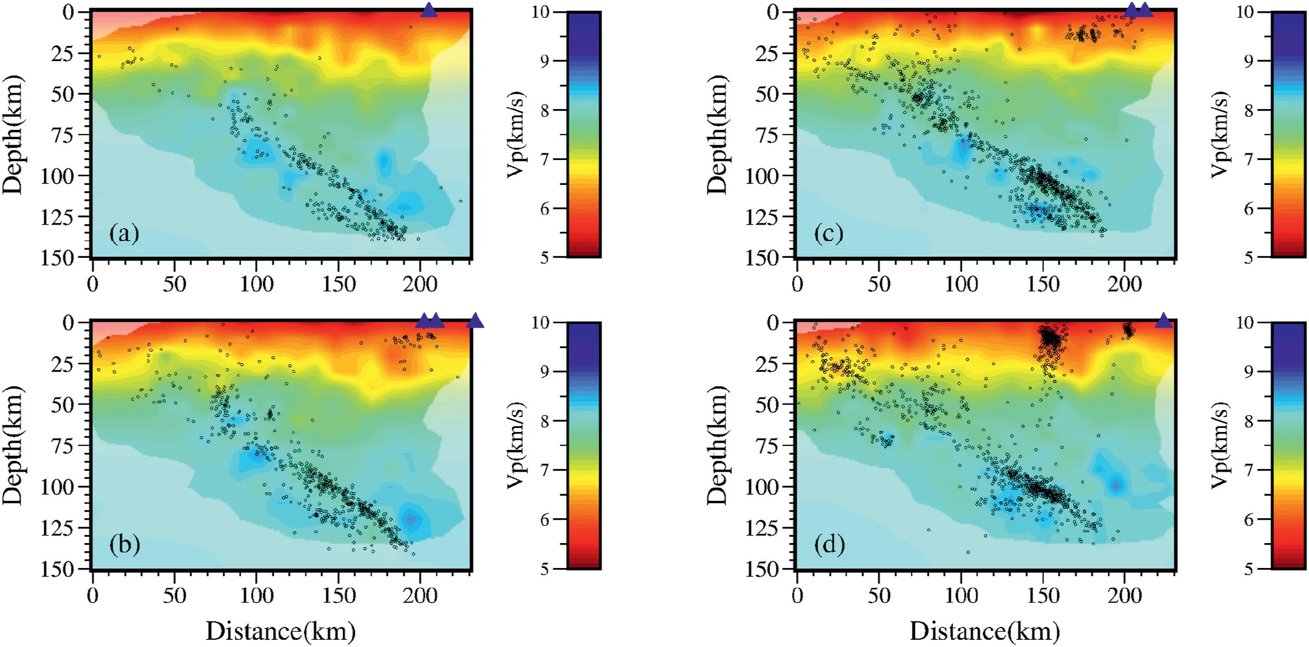
Fig.11.P-wave velocity model obtained by inversion along different latitudes.The location of the profiles is shown in Fig.1,with blue triangles indicating the location of the volcano and black dots indicating the earthquakes near the profile.The white shaded area is the area with low resolution determined based on the restoration of the checkerboard model.(For interpretation of the references to color in this figure legend,the reader is referred to the Web version of this article.)
The metamorphic evolution and dehydrating process of subducted oceanic crust can be predicted by combining the calculated Pressure-Temperature (P-T) path diagram with the metamorphic basalt phase equilibrium model.According to the global plate age distribution map,the age of the Nazca plate in our study area is about 50 Ma (Cande and Haxby,1991).Kirby (1991) proposes the concept of thermal parameter based on the age and subduction velocity of plate and suggeststhat the Nazca plate has a relatively low temperature.In such a cold slab,the pressure versus temperature paths for the oceanic crust first pass through the lawsonite blueschist metamorphic facies at low temperatures,forming lawsonite amphibolite which subsequently transforms to eclogite at higher temperatures (Hacker et al.,2003b;Hasegawa and Nakajima,2017;Peacock,1993;Peacock and Wang,1999;Yamasaki and Seno,2003).
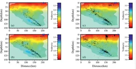
Fig.12.The same as Fig.11 but for the Vs model.
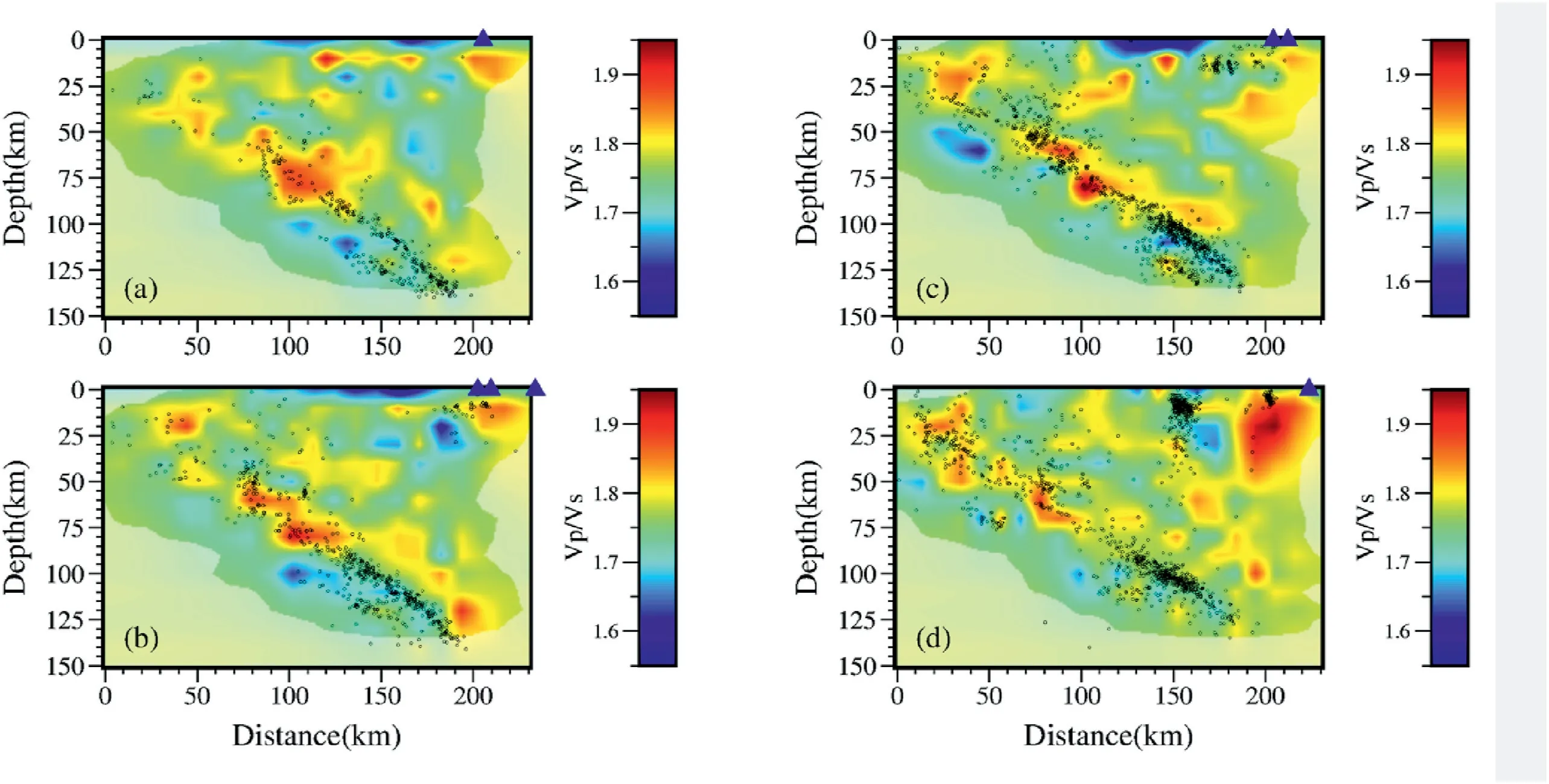
Fig.13.The same as Fig.11 but for the Vp/Vs model obtained from directly dividing Vp by Vs.
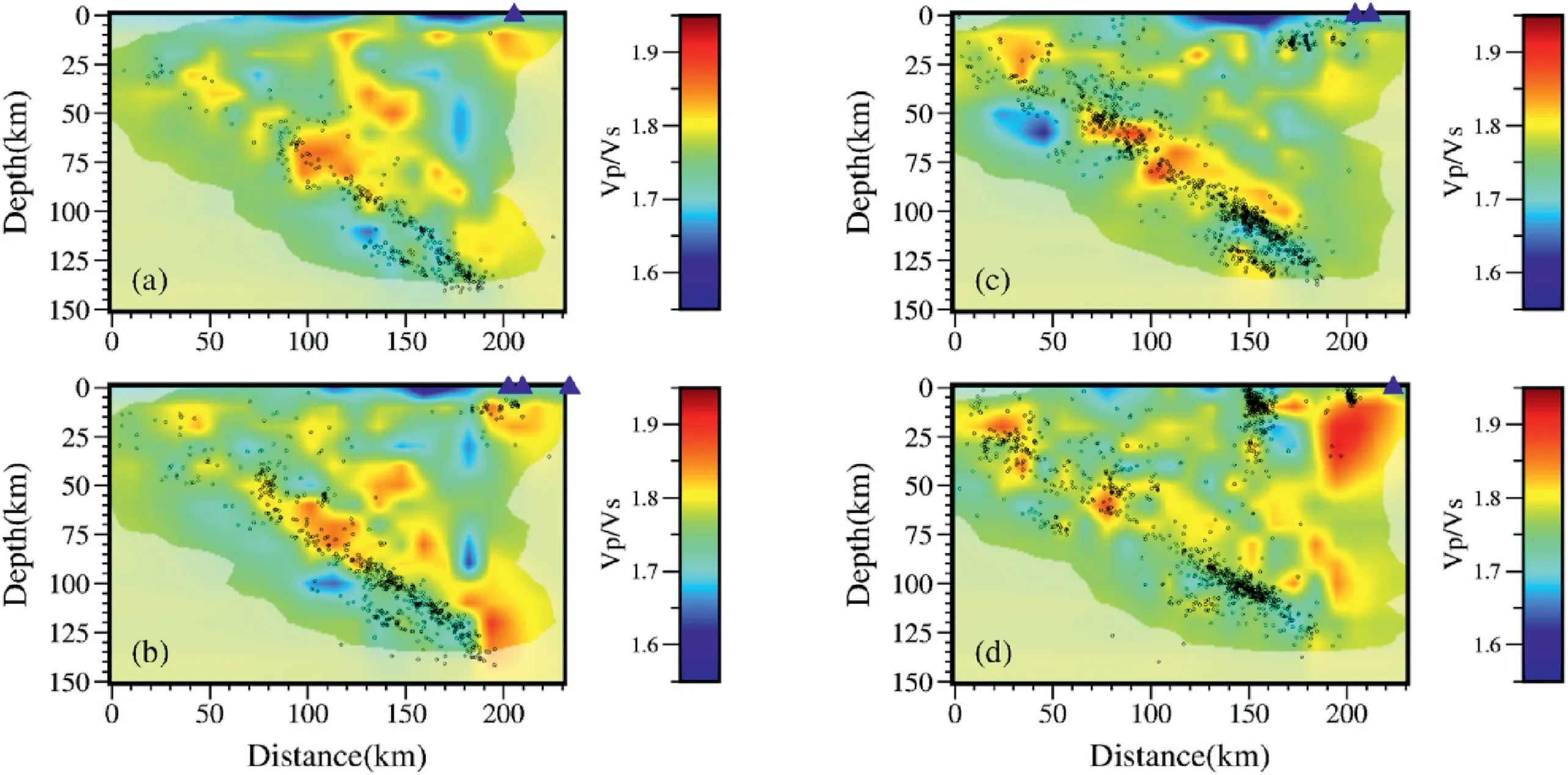
Fig.14.The same as Fig.11 but for the Vp/Vs obtained from directly inverting S-P times by the method of Guo et al.(2018).
The P-wave velocity of lawsonite blueschist is about 7.3 km/s,which decreases by about 7% relative to mantle peridotite (Helffrich,1996).While the P-wave velocity of lawsonite amphibolite is about 7.9 km/s(Hacker et al.,2003b) and has aVp/Vs ratio of 1.79-1.81.The seismic velocity of the eclogite at the pressure of 3-5 GPa ranges from 8.4 to 8.6 km/s,and the velocity ratio is about 1.8.Our velocity model is basically consistent with the results obtained by Yuan et al.(2000)using converted waves.The upper seismic zone of the double seismic zone is located in the oceanic crust of the subducted slab,and the velocity andVp/Vs are consistent with that of the lawsonite amphibolite,indicating that the formation of the upper seismic zone is probably induced by the hydrous minerals in the oceanic crust.The dehydration of hydrous minerals leads to the release of fluids and volatiles,which results in the increase of pore pressure and the decrease of effective normal stress,thereby leading to the generation of intermediate-depth earthquakes.Obviously,the anomaly of low seismic wave velocity and high wave velocity ratio may be caused by the mixture of blueschist and eclogite,implying that the dehydration reaction is in process and the blueschist has not been completely transformed into eclogite.In addition,we note that below 90 km depth,seismic wave velocity is larger than that above 90 km depth.Other features include smallerVp/Vs and more intense seismic activities,indicating the intensification of eclogization (Comte et al.,2016;Yuan et al.,2000).
5.2.Lower plane of the double seismic zone
Peacock (1993) compares the distribution of intermediate-depth earthquakes with the phase transformation path of serpentine dehydration,and finds that the two agree well.For this reason,the study suggests that serpentine dehydration induces intermediate-depth earthquakes,resulting in the formation of the lower plane of the double seismic zone.Other petrological experiments and theoretical calculations also indicate that the generation of the lower seismic zone is closely related to the dehydration of serpentine (Dobson et al.,2002;Hacker et al.,2003b;Yamasaki and Seno,2003;Xie et al.,2000;Yu and Jin,2005).Christensen (1996)suggests that serpentine has a highVp/Vs,even reaching 2.11.Our seismic tomography results show that the lower seismic zone is located in an obvious lowerVp/Vs(1.65-1.7)anomaly,which is similar to the imaging results of other subduction zones (Dorbath et al.,2008;Eberhart-Phillips and Bannister,2015;Nakajima et al.,2009;Zhang et al.,2004).
Reynard et al.(2010)propose that the ratio of lowVp and lowVp/Vs anomalies may be caused by anisotropy of anhydrous mantle peridotite in the lower seismic zone.The lower seismic zone is located 20-30 km below the oceanic crust,the depth zone that is consistent with the stress accumulation caused by slab bending.Such stress could induce partial embrittlement of mantle peridotite through shear instability at 650-800°C,thus generating earthquakes(Reynard et al.,2010).It is well acknowledged that thermal shear instability is often used to explain the cause of deep earthquakes.However,through the analysis of numerical simulation,Kelemen and Hirth (2007) indicate that thermal shear instability may also exist at intermediate depths.However,this interpretation cannot explain the fact that the lower seismic zone is associated with lowVp andVp/Vs.This is because if lower seismic zone is related to anhydrous mantle peridotite,the surrounding mantle areas should also show similar anomalies.Dorbath et al.(2008) argue that mantle only consists of limited types of rocks.If the mantle contains magnetite and clinopyroxene,S-wave velocity will be increased by the partially hydrated harzbugite,which is consistent with the results of our velocity model.Occurrence of magnetite is common in serpentinized rocks where it reaches up to 10 vol%of the rock(Coleman and Keith,1971).
Dehydration products of serpentine include forsterite,ensitite,and water,and geometrical characteristics of pores in the rock also affect seismic velocity and velocity ratio (Takei,2002).The upper mantle is primarily composed of forsterite(about 60%)and enstatite(about 40%)(Liu and Bassett,1986).Yamasaki and Seno(2003) calculate and obtain the temperature structure inside the slab based on the geological history of the slab in northern Chile.They indicate that the temperature of the mantle wedge and upper mantle part of the slab in this region is about 600-800°C,at which the serpentine would be decomposed into forsterite,enstatite and about 13 wt% water (Ulmer and Trommsdorff,1995).Experiments show that a forsterite-enstatite composite with a forsterite volume fraction of 0.6 has a P-wave velocity of approximately 8.5 km/s and an S-wave velocity of about 4.98 km/s under 2.5 GPa pressure(Ji and Wang,1999).Using linear extrapolation,P-and S-wave velocities may increase up to about 8.65 km/s and 5.05 km/s,respectively,at pressures of 4-5 GPa.By comparing these results with our velocity model,we find thatVp decreases by about 11%-15% andVs decreases by about 3%-7%from the normal slab to the anomalous lower seismic zone,corresponding to a change from anhydrous forsterite-enstatite to the forsterite-enstatite-water system with some hydrated minerals like serpentine (Zhang et al.,2004).For the latter system,water is likely to be present in spheroids,causing theVp/Vs ratio is well below 1.7 (Takei,2002).In this case,Vp would decrease more thanVs,which could explain the lowVp and lowVp/Vs anomalies in the lower seismic zone.
6.Conclusions
In this study,new three-dimensionalVP,VSandVP/VSmodels of the double seismic zone in northern Chile are obtained.Based on the analysis of the tomography results,we suggest that the interval between the two seismic zones in northern Chile is 15-20 km,with the upper seismic zone in the crust of the subducted plate and the lower seismic zone in the mantle of the subducted plate.The lowVp,lowVsand highVp/Vs features in the upper seismic zone are prominent,which are considered as being related to the eclogicalization of the hydrous minerals in the oceanic crust through a series of phase transformations.In addition,the water released by the phase transformations of hydrous minerals in the oceanic crust enters the overlying mantle,and induces the partial melting of the overlying mantle,leading to the volcanic activities in this region.However,the lower seismic zone shows obvious lowVp and lowVp/Vs,which is likely caused by the dehydration of serpentinite in the subducted mantle.
All of these evidences suggest that water plays a key role in generating intermediate-depth earthquakes.The results of deep reflection profile and focal mechanism show that normal faults occur in the Chile trench are due to plate bending,and the strike of normal faults is similar to the strike of earthquakes in the double seismic zone (Ranero and Sallares,2004).Therefore,it can be inferred that normal faults within the Nazca plate are generated due to slab bending before subduction.These normal faults penetrate through the oceanic crust and reach the mantle,leading to seawater infiltration followed by the upper mantle serpentinization.With the process of plate subduction,slab temperature and pressure increase gradually and finally reach the dehydration threshold of hydrous minerals.With the dehydration of various hydrous minerals and the accompanying embrittlement in the oceanic crust and mantle,a double seismic zone is generated.
Acknowledgements
We are grateful for two anonymous reviewers for their constructive comments.This research is supported by National Natural Science Foundation of China under grant (41861134009),the PIA ANID grant(AFB180004),and the ANID grant(PCI PII-180003).
 Earthquake Research Advances2021年1期
- Earthquake Research Advances的其它文章
- Application of Snell's law in reflection raytracing using the multistage fast marching method
- Viscoelastic relaxation of the upper mantle and afterslip following the 2014 MW 8.1 Iquique earthquake
- Fluid-driven seismicity in relatively stable continental regions:Insights from the February 3rd,2020 MS5.1 Qingbaijiang isolated earthquake
- Illuminating high-resolution crustal fault zones using multi-scale dense arrays and airgun source
- Research progress on layered seismic anisotropy-A review
- GUIDE FOR AUTHORS