Climatology and seasonal variability of satellite-derived chlorophyll a around the Shandong Peninsula*
Xiukai SONG , Yanzhen GU , Fangguo ZHAI ,**, Peiliang LI , Pengxia LIU ,Zizhou LIU , Wenfan WU , Yaozu CHEN , Xiangyang JIANG , Jianlong HE
1 Shandong Marine Resources and Environment Research Institute, Shandong Provincial Key Laboratory of Restoration for Marine Ecology, Yantai 264006, China
2 College of Oceanic and Atmospheric Sciences, Ocean University of China, Qingdao 266100, China
3 Institute of Physical Oceanography and Remote Sensing, Ocean College, Zhejiang University, Zhoushan 316021, China
4 Hainan Institute of Zhejiang University, Sanya 572025, China
Abstract The chlorophyll a (Chl a) is an important indicator of marine ecosystems. The spatiotemporal variation of the Chl a greatly aff ects the mariculture and marine ranching in coastal waters of the Shandong Peninsula. In the current study, the climatology and seasonal variability of surface Chl- a concentration around the Shandong Peninsula are investigated based on 16 years (December 2002-November 2018) of satellite observations. The results indicate that the annual mean Chl- a concentration is greater in the Bohai Sea than in the Yellow Sea and decreases from coastal waters to off shore waters. The highest Chl- a concentrations are found in Laizhou Bay (4.2-8.0 mg/m 3), Haizhou Bay (4.2-5.9 mg/m 3) and the northeast coast of the Shandong Peninsula (4.4-5.0 mg/m 3), resulting from the combined eff ects of the intense riverine input and long residence time caused by the concave shape of the coastline. The seasonal Chl- a concentration shows a significant spatial variation. The Chl- a concentrations in these three subregions generally exhibit an annual maximum in August/September, due to the combined eff ects of sea surface temperature, river discharge and sea surface wind. In the southeast coast region, however, the Chl- a concentration is lowest throughout the year and reaches a maximum in February with a minimum in July, forced by the seasonal evolution of the Yellow Sea Cold Water and monsoon winds. The interannual Chl- a concentration trends vary among regions and seasons. There are significant increasing trends over a large area around Haizhou Bay from winter to summer, which are mainly caused by the rising sea surface temperature and eutrophication. In other coastal areas, the Chl- a concentration shows decreasing trends, which are clearest in summer and induced by the weakening land rainfall. This study highlights the diff erences in the Chl- a dynamics among regions around the Shandong Peninsula and is helpful for further studies of coupled physical-ecological-human interactions at multiple scales.
Keyword: chlorophyll- a concentration; Shandong Peninsula; climatology; seasonal variability; Yellow Sea Cold Water
1 INTRODUCTION
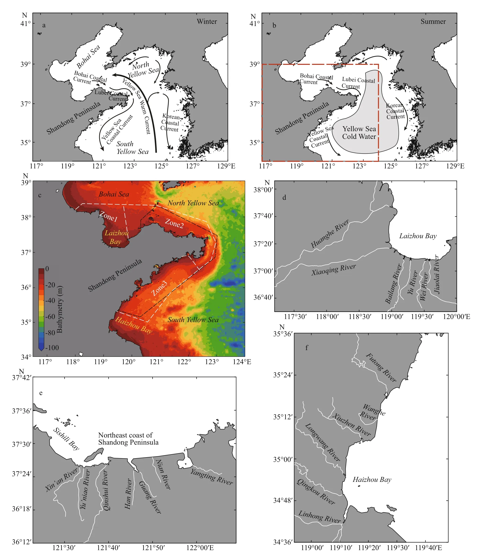
Fig.1 Major currents in the Bohai Sea and Yellow Sea
The Shandong Peninsula is located in the north of China (Fig.1a & b). The northern coast of the Shandong Peninsula is bordered by the Bohai Sea and North Yellow Sea, while its southern coast is bordered by the South Yellow Sea. The coastal waters of the Shandong Peninsula constitute an intensively maricultured area in China (Ren et al., 2019; Zhai et al., 2020). In past decades, there has been rapid expansion both in coastal aquaculture ponds and in off shore artificial reefs and marine ranches (Su and Yang, 2018; Ren et al., 2019; Zhai et al., 2020). By 2016, Shandong Province featured the second largest extent of coastal aquaculture ponds (2 291 km2) in China, accounting for approximately 17.6% of the total extent of coastal aquaculture ponds of the country (Ren et al., 2019). Meanwhile, there were more than 240 artificial reef districts, each with a construction investment totaling one million RMB and a total area exceeding 190 km2. In 2017, Shandong Province promulgated the “Construction Plan of Marine Ranching in Shandong Province (2017-2020)”, stating that there would be additional marine ranches constructed in the coastal regions of the Shandong Peninsula in the near future to further protect the environment of fishing grounds, enhance and utilize marine organism resources, and reinforce the conservation of the marine ecosystem (Fig.1c).However, the coastal waters of the Shandong Peninsula experience an extremely complicated dynamic environment under the combined forcing of the East Asian Monsoon system (Huang et al., 2012),shelf circulation, tide-induced mixing, and other factors (Su, 2001). In the surface layer of the coastal waters of Shandong Peninsula, the Bohai Coastal Current, Lubei Coastal Current, and Yellow Sea Coastal Current flow clockwise around the peninsula in both winter and summer monsoon seasons (Fig.1a& b; Fang et al., 2000; Naimie et al., 2001; Su, 2001;Zeng et al., 2015; Zhou et al., 2017a; Zhang et al.,2018). Meanwhile, the coastal waters of Shandong Peninsula are also influenced by human activities and strong land-ocean interactions. There are numerous rivers flowing from the land into coastal areas,providing substantial land-sourced nutrients for supporting high primary production and fisheries. The highly complex and variable environmental conditions around Shandong Peninsula exert a great impact on the construction and development of both coastal aquaculture ponds and off shore artificial reefs and marine ranches (Zhai et al., 2020).
Surface chlorophylla(Chla) is one of the most important factors influencing coastal mariculture and off shore marine ranching. On the one hand, the surface Chlais a reliable indicator of the biomass and abundance of marine phytoplankton, which dominates marine net primary production (Field et al., 1998) and is thus quite important for the growth of shellfishes,precious seafood, and other commercially valuable fishes in marine ranching. On the other hand, the subsidence and decomposition of surface layer marine phytoplankton consumes much dissolved oxygen and may lead to benthic hypoxia. The significant influence of the surface-sourced organic matter on the formation of the benthic hypoxic zone has been observed both in the Bohai Sea (Wei et al., 2019) and Changjiang(Yangtze) River estuary (Wei et al., 2015; Ni et al.,2016). Reduction in bottom-layer dissolved oxygen could greatly threaten the survival of benthic shellfishes, precious seafood, and other sea animals.Therefore, elucidating the spatiotemporal variation in the surface Chl-aconcentration and the underlying dynamics at multiple scales is quite important for marine resource development and marine ecological protection around the Shandong Peninsula, especially in the marine ranching area.
In the literature, studies have suggested that the surface Chl-aconcentration in the coastal waters of the Shandong Peninsula exhibits a significant spatiotemporal variation (Xin et al., 1997; Fu et al.,2009; Zhang et al., 2009; Yamaguchi et al., 2012; Ma et al., 2014). Historical field observations have indicated that the surface Chl-aconcentration inside Laizhou Bay (Fig.1d) generally decreases northward/northeastward and shows a significant seasonal variation, with the highest values occurring in late summer/early autumn (Lv et al., 1999; Cai et al.,2002; Sun et al., 2002; Wang and Li, 2002; Gao et al.,2003). This finding is consistent with MODIS satellite observations (Zhang et al., 2017). The spatial distribution and seasonal variation of the surface Chlaconcentration inside Laizhou Bay is closely related to sea surface temperature and land-sourced nutrients,which are dominated by riverine inputs (Shan et al.,2000; Gao et al., 2011; Zhou et al., 2015; Guo et al.,2016; Jiang et al., 2018). At the northern edge of Laizhou Bay, Zhou et al. (2017b) observed that the surface Chl-aconcentration was higher in April 2014 and June 2013 (approximately 4-5 mg/m3) than in November 2013 (~3.0 mg/m3), which may indicate a slightly diff erent seasonal variation from that inside Laizhou Bay. In addition to Laizhou Bay, the surface Chl-adynamics in Sishili Bay along the northeastern coast of the Shandong Peninsula (Fig.1e) has also attracted much attention. With in situ observations obtained in May-September from 2003 to 2008, Hao et al. (2011) showed that the surface Chl-aconcentration in Sishili Bay decreased from the coast to the open sea (Dong et al., 2019) and was greatest in August/September in all the years (Li et al., 2012).Similarly, Wang et al. (2012) found that the in situ observed surface Chl-aconcentration in Sishili Bay in 2009 reached its annual maximum in September,with a secondary peak in spring. Similar spatiotemporal variations in the surface Chl-aconcentration have also appeared in MODIS satellite observations (Ma et al., 2014; Shen et al., 2014). In addition, the May-September mean surface Chl-aconcentration in Sishili Bay showed an increasing trend from 2003(~3.0 mg/m3) to 2008/2009 (~13.0 mg/m3) (Yu et al.,2009; Hao et al., 2011). Hao et al. (2011) stated that the spatial and seasonal-interannual variations of the surface Chl-aconcentration in Sishili Bay are controlled by water temperature and nutrient loading from terrestrial sources during rainfall (Yu et al.,2009; Wang et al., 2012; Shen et al., 2014). The Chl-aconcentration was observed at densely sites in the southern coastal waters of the Shandong Peninsula in all four seasons during 2006-2007 (Fu et al., 2009).The observations indicated that the surface Chl-aconcentration showed a roughly sandwiched structure throughout the year, with high values around Haizhou Bay (Fig.1f) and the coastal regions of Yantai City and Weihai City, and low values in coastal areas of Qingdao City. In the Rushan Bay of Weihai City, Xin et al. (1997) observed that the surface Chl-aconcentration varied significantly from June to September and was highest in September (~45.26 mg/m3) in 1995. In Haizhou Bay, Zhang et al. (2009)observed that the surface Chl-aconcentration decreased sharply eastward away from the coast and was significantly greater in autumn (~10.0-36.0 mg/m3) than in spring (~1.0 mg/m3) in 2003. Liu et al.(2015) also observed that the surface Chl-aconcentration increased from winter (1.42 mg/m3) to autumn (9.27 mg/m3) during 2012/2013. The seasonal variation is consistent with the observations of Fu et al. (2009), who showed that the surface Chl-aconcentration in the outer region of Haizhou Bay was highest in autumn (>5.0 mg/m3) during 2006/2007. In the middle region of the southern coast of the Shandong Peninsula, in situ observations indicated that the surface Chl-aconcentration was highest in autumn during 2006/2007 (Fu et al., 2009). This result was slightly diff erent from the 10-year averages from SeaWiFS satellite observations, which showed that the surface Chl-aconcentration peaked in winter(Yamaguchi et al., 2012).
The above studies have greatly advanced our understanding of the spatiotemporal variations of the surface Chl-aconcentration in the coastal waters of the Shandong Peninsula. However, previous in situ observations have been discontinuous in both space and time. It is diffi cult for us to fully understand the surface Chl-adynamics at multiple scales based on limited in situ observations. On the contrary, the accumulation of high-quality MODIS satellite observations over the past few decades provides us with an eff ective means to explore the climatology and multiscale variations of the surface Chl-aconcentration in the coastal waters and adjacent seas of the Shandong Peninsula. In coastal waters, the accuracy of the satellite-derived surface Chl-aconcentration is greatly impacted by sediment resuspension caused by wind, tidal currents and mixing(Gong et al., 2003; Shi and Wang, 2010). Although uncertainties still exist (Wang et al., 2019; Wang and Gao, 2020), the surface Chl-adynamics in diff erent coastal and off shore regions have been distilled from satellite observations (Shi and Wang, 2012a; Liu and Wang, 2013; Shen et al., 2014; Qiao et al., 2017; Sun et al., 2019). In the current study, we aim to investigate the climatology and seasonal variability of the surface Chl-aconcentration around the Shandong Peninsula and the underlying mechanisms using 16 years(December 2002-November 2018) of satellite ocean color observations. This is the first time that the varying dynamics of the Chl-aspatiotemporal variation at diff erent scales around the Shandong Peninsula have been highlighted. The current results are useful for future marine resource planning and marine ecological management in Shandong Province.
2 DATASET AND METHODOLOGY
2.1 Dataset
2.1.1 Chl-aconcentration and photosynthetically available radiation
The level 3 monthly composite Chl-aconcentration and photosynthetically available radiation retrieved by MODIS/Aqua were obtained from the Asia-Pacific Data-Research Center of International Pacific Research Center and the National Oceanic and Atmospheric Administration OceanWatch-Central Pacific node, respectively. The MODIS Chl-aconcentration product was calculated combining the ocean Chlathree-band algorithm for MODIS(OC3M; O’Reilly et al., 1998) and a color index algorithm (Hu et al., 2012). The OC3M algorithm is a fourth-order polynomial relationship between the Chl-aconcentration and the ratio of two MODIS remote sensing reflectance bands (O’Reilly et al.,1998; Wang et al., 2019). The color index algorithm is a three-band reflectance diff erence algorithm employing the diff erence between the remote sensing reflectance in the green band and a reference formed linearly between the remote sensing reflectance in the blue and red bands (Hu et al., 2012). The OC3M algorithm was used for Chl-aconcentration retrievals above 0.2 mg/m3, while the color index algorithm was used for Chl-aconcentration retrievals below 0.15 mg/m3. For Chl-aconcentration retrievals in between these values, the two algorithms were blended using a weighted approach. More details can be found at https://oceancolor.gsfc.nasa.gov/atbd/chlor_a/#sec_2. Def nied as the total amount oflight available for photosynthesis in the 400- to 700-nm wavelength range at the sea surface, photosynthetically available radiation controls marine phytoplankton photosynthesis and thus regulates the surface Chl-aconcentration (Frouin et al., 1989). The horizontal resolutions of the Chl-aconcentration and photosynthetically available radiation are approximately 9 km and 4 km, respectively. The two data sets adopted here both span from December 2002 to November 2018.
2.1.2 Sea surface temperature
The level 4 high resolution daily sea surface temperature (SST) data set prepared by the Operational Sea Surface Temperature and Sea Ice Analysis(OSTIA) system was downloaded from the Asia-Pacific Data-Research Center of the International Pacific Research Center. The data set is produced by merging microwave and infrared satellite observations and in situ observations available over the Global Telecommunications System using the optimum interpolation method at the Met Offi ce (Donlon et al.,2012). The data set covers the global ocean with a horizontal resolution of 1/20° (~6 km). With such a high horizontal resolution, the data set is able to describe the spatiotemporal variation of the sea surface temperature in detail at regional scales and was thus used to examine the climatological annual distribution and seasonal dynamics of Chl-aconcentration in spatially complex coastal regions of the Shandong Peninsula. The data set spans from April 2006 to the present.
In addition, the daily optimum interpolation sea surface temperature (OISST) version 2 data set(Reynolds et al., 2007), which has a longer time period (September 1981 to the present) than the OSTIA data set was adopted to help understand the interannual trends of the surface Chl-aconcentration.The data set was downloaded from the National Oceanic and Atmospheric Administration National Centers for Environmental Information. The data set is prepared with Advanced Very High-Resolution Radiometer infrared satellite observations and in situ data from ships and buoys using the optimum interpolation method. A large-scale adjustment of satellite biases with respect to the in situ data is included. The OISST data set utilized here covers the global ocean with a horizontal resolution of 0.25°(~22 km) and over the same period as the satellitederived Chl-aconcentration. Both daily SST data sets were composed into monthly averages to match the Chl-aconcentration data set.
2.1.3 Sea surface wind
To examine the eff ect of sea surface wind forcing on Chl-adynamics, we used the sea surface 10-m wind vectors derived from the fifth generation of atmospheric reanalysis of the global climate prepared by the European Centre for Medium-Range Weather Forecasts (ERA5; Hersbach et al., 2020). Through combining vast amounts of historical observations into global estimates using advanced modelling and data assimilation systems, the ERA5 provides hourly estimates of a large number of atmospheric, land and oceanic climate variables. The ERA5 covers the earth on a 30-km grid and resolves the atmosphere using 137 levels from the surface up to a height of 80 km.The ERA5 sea surface wind has a horizontal resolution of 0.25° (~22 km) and a time interval of 6 hours. The 6-hourly surface wind vectors spanning from 1979 to the present were averaged into monthly means.
2.1.4 Land rainfall
Global monthly land rainfall was used to help understand the spatiotemporal variations of the riverine input nutrient contents in the coastal regions around the Shandong Peninsula. The land rainfall data set was downloaded from the Asia-Pacific Data-Research Center of the International Pacific Research Center. This data set is produced through interpolating gauge observations from over 15 000 stations collected from the version 2 data set of the Global Historical Climatology Network of the National Oceanic and Atmospheric Administration/National Climatic Data Center and the Climate Anomaly Monitoring System of the National Oceanic and Atmospheric Administration/Climate Prediction Center using the optimum interpolation algorithm(Chen et al., 2002). The horizontal resolution of this data set is 0.5° (~44 km). The monthly land rainfall data span from 1948 to the present.
2.2 Methodology
2.2.1 Correction of satellite observation
Previous observations have indicated that the MODIS/Aqua generally overestimates Chl-aconcentrations, especially in highly turbid waters(Cui et al., 2010; Yamaguchi et al., 2013; Wang et al.,2019). However, the MODIS/Aqua retrievals seem to be consistent with in situ observations both in terms of spatial distribution and temporal variation. Cui et al. (2010) assessed satellite observations of turbid coastal waters of the Bohai Sea with in situ observations at many stations obtained during 2003-2007. The results indicated that although the satellite observations generally overestimated the in situ measurements, the correlation coeffi cients were 0.94 for the 18 strict match-ups and 0.84 for the 43 strict and relaxed match-ups. Significant correlations between satellite and in situ observations have also been observed in other Chinese coastal regions(Zhang et al., 2006). In the current study, we have no in situ observations on hand to validate and correct the satellite observations in the coastal waters of the Shandong Peninsula. However, using field observations with good coverage for all the coastal waters of the Shandong Peninsula, He et al. (2013)found that the MODIS Chl-aconcentration retrievals on a logarithmic scale were highly correlated with in situ observations (correlation coeffi cient=0.72).Based on the 39 strict match-ups, they demonstrated that the MODIS Chl-aconcentration could be corrected with linear regression following log(ChlaC)=1.281 8×log(Chla)-0.383 8, where the ChlaCis the Chl-aconcentration after correction. The linear regression derived by He et al. (2013) was adopted to correct the satellite observations before further analysis in this study.
2.2.2 Calculation ofinterannual trends
In this study, seasons refer to those for the Northern Hemisphere. For example, summer refers to June,July, and August and winter refers to December,January, and February.
In addition to the climatological seasonal variability, the interannual trends of the annual and seasonal means of Chl-aconcentration were also calculated using the least-squares fitting method. The statistical significance of the linear trends was assessed with the nonparametric Mann-Kendall test(Mann, 2004). Following Liu and Wang (2013) and Wang et al. (2019), we used quartile-based statistics to describe the characteristics of Chl-aconcentration owing to its lognormal distribution (Campbell, 1995).The Chl-aconcentration was base-10 log-transformed before any operations, and the expectations were estimated as medians, which are more robust than means with respect to outliers and closer to modal values (Wang et al., 2019).
3 RESULT
3.1 Climatological annual medians and variability
Figure 2 shows the climatological monthly variation of the percentage of valid Chl-aconcentration at each grid point around the Shandong Peninsula during the entire time period. For each grid point in each climatological month, the percentage of valid Chl-aconcentration was calculated as 100%×NV/NT,whereNTis the total number of years andNVis the number of years with valid Chl-aconcentration in that month. The percentage of valid Chl-aconcentration showed a significant seasonal variation,with two peaks occurring in spring (March/May) and autumn (September) and two troughs in winter(December/January) and summer (June/July). Valid Chl-aconcentration is greatly influenced by cloud cover (He et al., 2013) and water turbidity (He et al.,2012). In extremely turbid waters, failure of atmospheric correction and oversaturation of radiance are thought to lead to invalid satellite-observed Chl-aconcentrations (He et al., 2012). Therefore, the low percentage of valid Chl-aconcentration in summer is due to heavy cloud cover, while that in winter is attributed to the highest water turbidity of the year(Shi and Wang, 2012a). Additionally, sea ice may have led to the low percentage of valid satellite retrievals in winter (Shi and Wang, 2012b). The percentages of valid Chl-aconcentration in most areas around the Shandong Peninsula were well above 60%. Relatively low percentages were present only for the southwestern portion of Bohai Sea, due to the sea ice coverage and extremely high turbidity caused by the strong sea surface wind in winter and large quantities of sediment transport from the Huanghe(Yellow) River in summer (Shi and Wang, 2012a, b).
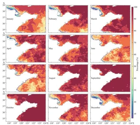
Fig.2 Climatological monthly variation of the percentage (%) of valid Chl- a concentration over the entire time period

Fig.3 Distribution of the climatological annual median (a) and variability (b) of the monthly satellite-derived Chl- aconcentration (mg/m 3)
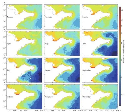
Fig.4 Climatological monthly median Chl- a concentration (mg/m 3) around the Shandong Peninsula
We then calculated the climatological annual median and variability of Chl-aconcentration using monthly Chl-aconcentrations. In the current study, variability is represented by the diff erence between the 75thand 25thpercentiles of the time series (Liu and Wang, 2013).For each grid point, the annual median and variability of Chl-aconcentration were calculated only when the percentages of valid Chl-aconcentration in at least 10 climatological months were greater than 50% (Fig.2).As shown in Fig.3, both the climatological annual median and variability were consistent with findings of previous studies (He et al., 2013; Zhang et al., 2017).The climatological median Chl-aconcentration was higher in the Bohai Sea than in the Yellow Sea and declined from coastal waters to off shore waters (Zhu et al., 1993; Wei et al., 2004; Zhang et al., 2009; Wang et al., 2012; Liu and Wang, 2013), consistent with previous sparse in situ observations (Lv et al., 1999;Sun et al., 2002; Wang and Li, 2002; Dong et al., 2019;Yang and Gao, 2019). The spatial pattern reflects the importance ofland-sourced nutrients for supporting high primary production (Field et al., 1998; Gong et al.,2006; Qu and Kroeze, 2010; Li et al., 2015). Around the Shandong Peninsula, the highest Chl-aconcentration appeared in Laizhou Bay (4.2-8.0 mg/m3), the northeast coast of the Shandong Peninsula (4.4-5.0 mg/m3) and Haizhou Bay (4.2-5.9 mg/m3) (He et al., 2013).Note that the high Chl-aconcentration in Laizhou Bay extended toward the open ocean much farther than in Haizhou Bay and along the northeast coast of the Shandong Peninsula. In broad regions along the southeast coast of the Shandong Peninsula, however,the Chl-aconcentration was relatively low (<3.0 mg/m3), which is associated with the low Chl-aconcentration tongue originating from the central South Yellow Sea.
Similar to the climatological annual median Chl-aconcentration, the variability of the monthly Chl-aconcentration was highest in South Laizhou Bay, the northeast coast of the Shandong Peninsula and Haizhou Bay. Of the three regions, South Laizhou Bay experienced the strongest seasonal variability in Chl-aconcentration. In addition, the variability was also high along the southeast coast of the Shandong Peninsula. Away from the coast, high variability mainly occurred in the western South Yellow Sea and western North Yellow Sea.
3.2 Climatological seasonal variation
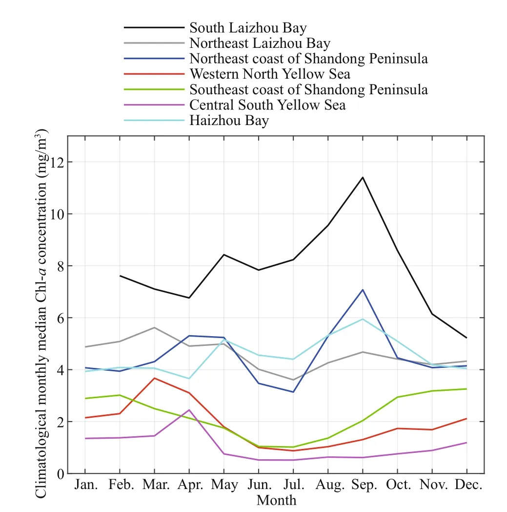
Fig.5 Climatological monthly median Chl- a concentration(mg/m 3) averaged in the subregions marked in Fig.3b
Figure 4 shows the climatological monthly median Chl-aconcentration. Note that the climatological monthly median Chl-aconcentration at each grid point was calculated only when the percentage of valid Chl-aconcentration in that climatological month was greater than 50% (Fig.2). The most prominent feature of the climatological seasonal pattern of Chl-aconcentration around the Shandong Peninsula is that it showed a significant spatial diff erence. The seasonal dynamics of Chl-aconcentration along the southeast coast of the Shandong Peninsula resulted in a significant growth process in winter and spring (December-March) and an obvious depletion from late spring to early autumn(May-September). This pattern is similar to the seasonal dynamics of Chl-aconcentration in the central South Yellow Sea, except in April, when spring blooms in the central South Yellow Sea induce the highest Chl-aconcentration of the year (Xing et al., 2012; Liu and Wang, 2013; Zhou et al., 2013).From late spring to early autumn (May-September),there is a significant low Chl-aconcentration tongue extending from the central South Yellow Sea to southeast coastal areas of the Shandong Peninsula (Fu et al., 2009; Qu et al., 2015; Zhou et al., 2018). In other coastal areas of the Shandong Peninsula,however, the surface Chl-aconcentration generally increased slowly from winter to late summer/early autumn (August/September) and then decreased rapidly to the subsequent winter.
To more clearly observe the spatial variation in seasonal Chl-adynamics, Fig.5 presents the climatological monthly median Chl-aconcentration averaged for seven subregions as marked by magenta rectangles in Fig.3b. Note that in South Laizhou Bay,the climatological monthly median Chl-aconcentration in January is missing due to the low percentage of valid satellite observations (Fig.2). In the coastal waters of the Shandong Peninsula, South Laizhou Bay experienced the highest Chl-aconcentration (>6.0 mg/m3) throughout the year. The area- a veraged Chl-aconcentrations in South Laizhou Bay, Haizhou Bay and the northeast coast of the Shandong Peninsula shared similar seasonal variations, each with an annual maximum in late summer (August)/early autumn(September) and a secondary maximum in late spring.This type of seasonal variation agrees well with sparse in situ observations (Sun et al., 2002; Hao et al., 2011;Li et al., 2012; Wang et al., 2012; Liu et al., 2015).This seasonal variation is also similar to results from the Qinhuangdao Coast and central Bohai Sea (Zhang et al., 2017). The surface Chl-aconcentration in Northeast Laizhou Bay, on the contrary, reached its annual maximum in spring and a secondary maximum in autumn (September), similar to that in the Bohai Strait (Zhang et al., 2017).
The Chl-aconcentration averaged along the southeast coast of the Shandong Peninsula showed a diff erent seasonal variation, which was highest in winter and lowest in summer (July). The seasonal Chl-aconcentration patterns averaged in the western North Yellow Sea and central South Yellow Sea were nearly identical to each other, exhibiting annual maxima in spring (March/April) and minima in summer (June/July). In the off shore waters of the Yellow Sea, the eff ect of spring blooms resulting in the occurrence of annual Chl-aconcentration maxima in spring has been reported from both satellite and in situ observations (Fu et al., 2009; Yamaguchi et al.,2012; Liu and Wang, 2013; Zhou et al., 2013).
To conclude, the surface Chl-aconcentration around the Shandong Peninsula displayed diff erent seasonal variations in diff erent regions. Along the southeast coast, the surface Chl-aconcentration was highest in late winter and lowest in summer. In South Laizhou Bay, Haizhou Bay and along the northeast coast of the Shandong Peninsula, however, the surface Chl-aconcentration was greatest in late summer/early autumn, with a secondary maximum in late spring.
3.3 Interannual trends
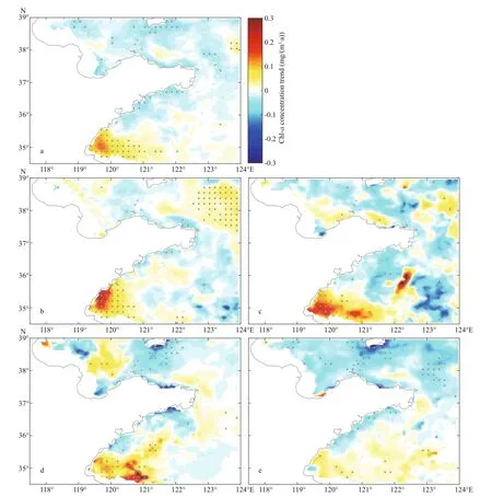
Fig.6 Interannual trends (mg/(m 3·a)) of annual (a), winter (b), spring (c), summer (d) and autumn (e) mean Chl- aconcentration
In addition to seasonal variability, significant interannual trends in surface Chl-aconcentration have also been observed in both coastal and off shore areas in eastern Chinese seas (Yu et al., 2009; Hao et al., 2011; Fu et al., 2012; Liu and Wang, 2013; Zhang et al., 2017). In coastal areas of the Shandong Peninsula, an interannual trend of Chl-aconcentration has only been recorded by field observations in Sishili Bay, which indicated that there was an increasing trend in the May-September mean surface Chl-aconcentration from 2003 to 2008/2009 (Yu et al.,2009; Hao et al., 2011). In the current study, it is useful to further examine the interannual trends of surface Chl-aconcentration around the Shandong Peninsula with long-term, continuous, and broadscale satellite-derived data. Figure 6 shows the interannual trends of the annual mean and seasonal mean Chl-aconcentrations around the Shandong Peninsula. The most prominent feature is that there were increasing trends in Chl-aconcentration significant above the 95% confidence level over a large area around Haizhou Bay in all seasons except autumn. The maximum increasing trends were 0.155 mg/(m3·a) around (119.7°E, 35°N) for the annual mean Chl-aconcentration, 0.314 mg/(m3·a)around (119.8°E, 35.5°N) just off Rizhao City for the winter mean Chl-aconcentration, 0.246 mg/(m3·a)around (119.7°E, 35°N) for the spring mean Chl-aconcentration and 0.524 mg/(m3·a) around (121°E,34.7°N) for the summer mean Chl-aconcentration. In other coastal areas, the interannual Chl-aconcentration trends were generally decreasing and mostly below the 95% confidence level. The decreasing trends seemed to be clearer in summer than in other seasons.
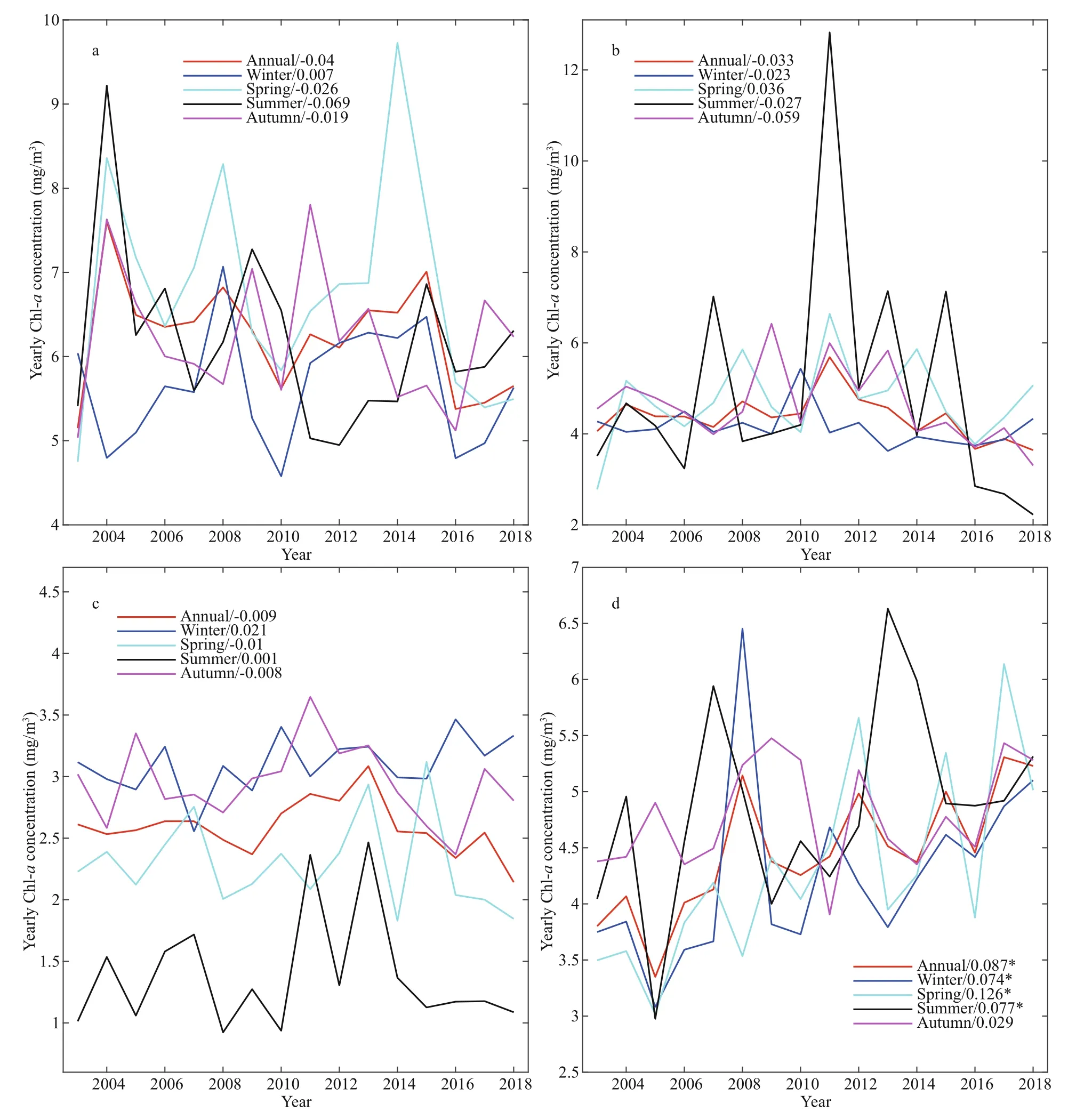
Fig.7 Yearly time series of the annual (red line), winter (blue line), spring (cyan line), summer (black line) and autumn(magenta line) mean Chl- a concentration averaged in Laizhou Bay (a), northeast coast of the Shandong Peninsula (b),southeast coast of the Shandong Peninsula (c), and Haizhou Bay (d)
To provide more details about the spatial variation in interannual Chl-aconcentration trends, Fig.7 presents the yearly time series of the annual and seasonal mean Chl-aconcentrations averaged in the four subregions. As seen from the figure, the surface Chl-aconcentration exhibited significant interannual variations in all the subregions but significant increasing trends in Haizhou Bay only in winter-tosummer seasons (above the 95% confidence level).Along the northeast coast of the Shandong Peninsula,the surface Chl-aconcentration seems to have had an increasing trend before 2010/2011 but a decreasing trend afterwards. The increasing satellite-derived Chl-aconcentration trend before 2010/2011 is consistent with previous field observations (Yu et al.,2009; Hao et al., 2011).
4 MECHANISM
As shown above, the surface Chl-aconcentration around the Shandong Peninsula exhibited significant spatiotemporal variations in terms of seasonal variability and interannual trends. In this section, the potential influencing factors, including temperature,wind, light, and precipitation, are discussed to better understand the underlying Chl-adynamics.
4.1 Processes related to climatological annual mean Chl- a concentration
The climatological annual median Chl-aconcentration around the Shandong Peninsula decreased from coastal waters to off shore waters(Fig.3a). This pattern is consistent with in situ observations of Chl-aconcentration over the global ocean (Gregg and Conkright, 2002; Yoder and Kennelly, 2003). The Chl-aconcentration pattern matches the spatial pattern of nutrients well, which also decrease from coastal waters to off shore waters(Yu et al., 2000; Lin et al., 2005; Gao et al., 2011; Liu et al., 2011; Wang et al., 2012). The high nutrient levels in coastal waters mainly result from land runoff ,riverine input, and intense land-ocean interactions(Zhang, 1996; Wang et al., 2003; Qu and Kroeze,2010; Hao et al., 2011; Jiang et al., 2018).
Meanwhile, the annual mean Chl-aconcentration showed significant spatial diff erences around the Shandong Peninsula (Fig.3a). The highest Chl-aconcentration appeared in Laizhou Bay, Haizhou Bay and northeast coast of the Shandong Peninsula, quite possibly due to the combined eff ects of the intense riverine input and long residence time caused by the concave shape of the coastline (Fig.1d-f). On the one hand, there are numerous rivers in these regions that transport large amounts of nutrients into the ocean to enhance significantly nutrient concentrations (Zhang,1996; Jiang et al., 2018). On the northwest corner of Laizhou Bay is the mouth of the Yellow River, which is the second largest river in China, with an annual mean discharge of approximately 292.8×10¹⁰m3. The Xiaoqing River empties into the southwest corner of Laizhou Bay. The combined nutrient fluxes of the Huanghe River and Xiaoqing River cause the nutrient concentrations in Laizhou Bay to decrease from southwest to northeast (Shan et al., 2000; Guo et al.,2016; Jiang et al., 2018), which further results in the monthly mean Chl-aconcentration also decreasing from southwest to northeast (Figs.3a & 4). On the other hand, the concave geometry of the coastlines of both Laizhou Bay and Haizhou Bay favors a long residence time, which can further increase nutrient concentrations and help phytoplankton grow (Liu and Wang, 2013; Guo et al., 2016; Jiang et al., 2018).
The local Chl-aconcentration maximum appearing along the northeast coast of the Shandong Peninsula(Fig.3a) was also quite possibly due to the same mechanisms as those acting in Laizhou Bay and Haizhou Bay (Fig.1d-f; Hao et al., 2011; Wang et al.,2012). In addition to the local riverine input, land runoff , and land-ocean interactions, the coastal currents around the Shandong Peninsula (Bohai Coastal Current, Lubei Coastal Current, and Yellow Sea Coastal Current), which exist in both winter and summer (Naimie et al., 2001; Su, 2001; Zeng et al.,2015; Zhang et al., 2018) may also have contributed to the higher levels of Chl-aconcentration observed in the northern coastal waters of the Shandong Peninsula than in the southern coastal waters by transporting nutrient-rich waters from the Bohai Sea to the Yellow Sea clockwise around the peninsula.
The fact that the high Chl-aconcentration extended toward the open ocean much farther in Laizhou Bay than in Haizhou Bay and the northeast coast of the Shandong Peninsula may have been due to many reasons. One important reason is related to the mouth of the Huanghe River located at the northwest corner of Laizhou Bay (Fig.1d), which inputs a large amount of nutrients into North Laizhou Bay. Another important reason is related to sea surface wind forcing (Fig.8a).In Laizhou Bay, the annual mean sea surface wind blows northwestward/northward and drives the nutrient-rich coastal surface water to flow northwestward/northward to the open sea and thus helps increasing the nutrient concentrations in off shore waters far from the coast, resulting in a much larger area with high Chl-aconcentration. Around Haizhou Bay, however, the annual mean sea surface wind blows westward. The corresponding surface currents also flow toward the bay (Yanagi and Takahashi, 1993;Naimie et al., 2001) and greatly hinder the nutrientrich coastal surface water from extending eastward to the open sea. As a result, surface nutrients are confined within Haizhou Bay, leading to a much smaller area with high Chl-aconcentrations in Haizhou Bay than in Laizhou Bay (Fig.3a).
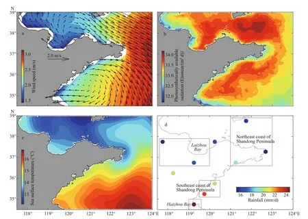
Fig.8 Climatological annual mean sea surface 10-m wind vectors (arrows; m/s) and speed (color; m/s) (a), photosynthetically available radiation (Einstein/(m 2·d)) (b), sea surface temperature (°C) (c), and rainfall (mm/d) during 2003-2018 (d)
In eastern Laizhou Bay and northeast coast of the Shandong Peninsula, the photosynthetically available radiation (Fig.8b) is high, favoring phytoplankton growth and thus perhaps also contributing to the relatively high Chl-aconcentration (Fig.3a). In western Laizhou Bay and Haizhou Bay, however, the photosynthetically available radiation is low. As the water in Laizhou Bay and Haizhou Bay is highly turbid due to the large sediment discharge from rivers(Shi and Wang, 2012a; Zhang et al., 2015), the light availability for marine phytoplankton growth would be much smaller than in other regions, which further proves that the high Chl-aconcentrations in these two areas are dominated by rich nutrients.
Finally, both the sea surface temperature (Fig.8c)and land rainfall (Fig.8d) decrease northward. Their spatial distributions are quite diff erent from those of the climatological mean Chl-aconcentration around the Shandong Peninsula, which indicates that there are no significant causal relationships between them on average (Zhang et al., 2017).
Therefore, the climatological annual mean distribution of the surface Chl-aconcentration around the Shandong Peninsula is mainly determined by land-sourced nutrients. The shape of the coastline, sea surface winds and photosynthetically available radiation also make certain contributions in specific regions.
4.2 Processes related to the climatological seasonal variation of Chl- a concentration
Figure 9 presents the climatological monthly mean sea surface temperature, sea surface wind,photosynthetically available radiation, and land rainfall around the Shandong Peninsula. The sea surface temperature, photosynthetically available radiation, and land rainfall display spatially coherent seasonal variations over the whole region. The sea surface temperature following January reaches its annual maximum in August and then decreases. The photosynthetically available radiation and land rainfall show similar seasonal variations, but with their annual maxima occurring in June and July,respectively. The sea surface wind is controlled by the East Asian Monsoon system (Huang et al., 2012). The annual mean surface wind blows southward/southeastward from autumn to winter (September to February in the subsequent year) and shifts to blowing northward from spring to summer (April to August).The wind speed reaches its annual maximum in December/January in the eastern part of the Shandong Peninsula and in June/July in the western part.
On the seasonal time scale, the most prominent feature is that the surface Chl-aconcentration along the southeast coast of the Shandong Peninsula showed nearly opposite variation to the levels in other coastal waters of the Shandong Peninsula (Fig.5). This finding implies quite diff erent Chl-adynamics in diff erent regions around the Shandong Peninsula. For comparison, Fig.10 shows the climatological monthly mean sea surface temperature, sea surface wind,photosynthetically available radiation and land rainfall averaged in Laizhou Bay, Haizhou Bay, and along the northeast and southeast coasts of the Shandong Peninsula (magenta rectangles in Fig.8d).As discussed above, the seasonal Chl-adynamics along the southeast coast of the Shandong Peninsula are quite possibly identical to those in the central South Yellow Sea, as the Chl-aconcentrations in these two regions show nearly identical seasonal variations (Fig.5; Xing et al., 2012; Liu and Wang,2013). Liu and Wang (2013) argued that the summer minimum of the surface Chl-aconcentration in the central Yellow Sea is mainly related to the Yellow Sea Cold Water (Fig.1b), which is the dominant water mass in the central Yellow Sea below the thermocline(Naimie et al., 2001). On one hand, the existence of the Yellow Sea Cold Water would significantly suppress the vertical mixture of nutrients between surface and bottom waters. On the other hand, the cyclonic circulation induced by the Yellow Sea Cold Water (Su, 1998) greatly weakens the horizontal nutrient exchange between coastal and off shore waters. We note that the spatial pattern of the surface Chl-aconcentration agrees quite well with that of the Yellow Sea Cold Water along the southeast coast of the Shandong Peninsula (see Fig.4 in Naimie et al.(2001)). Moreover, the prevailing summer monsoon winds also slow the horizontal nutrient transport from coastal waters to the central Yellow Sea (Figs.9 & 10).We thus can conclude that the low Chl-aconcentration along the southeast coast of the Shandong Peninsula results from the same dynamics as observed in the central Yellow Sea except in spring, when phytoplankton blooms occur only in the central Yellow Sea (Zhou et al., 2013). The surface Chl-aconcentration along the southeast coast of the Shandong Peninsula decreases with the development of the Yellow Sea Cold Water and the transition of the sea surface wind from northerly winter monsoon to southerly summer monsoon (Figs.9 & 10).
In Laizhou Bay, Haizhou Bay and along the northeast coast of the Shandong Peninsula, the seasonal Chl-adynamics diff er from those along the southeast coast of the Shandong Peninsula. The land rainfall reaches the annual maximum in July (Fig.10f),leading to the river discharge maximum occurring in July-September (Ren et al., 2002; Zhang et al., 2010).The river discharge transports abundant nutrients into the sea (Zhang et al., 2010; Liu et al., 2013; Guo et al.,2016). At the same time, the sea surface temperature reaches its annual maximum in August (Fig.10a). On one hand, warm water favors the rapid growth of phytoplankton. On the other hand, a high sea surface temperature tends to induce strong ocean stratification along with weak sea surface winds (Fig.10b) and a large amount of fresh water by river discharge and rainfall over the ocean. Comparisons of the satelliteobserved sea surface temperature and in situ observed bottom-layer temperature in the marine ranching area indicate that the ocean stratification is usually strongest in July-August in the coastal waters of the Shandong Peninsula (Li et al., 2019; Liu et al., 2019;Wang et al., 2020). The riverine input nutrients are then restricted to the thin surface layer due to ocean stratification. In Haizhou Bay, the westward zonal wind is also strongest in August (Fig.10c) and tends to restrict nutrients from extending eastward away from the coast. High nutrient concentrations facilitate the phytoplankton bloom that occurs in late summer/early autumn, thus leading to the annual maximum Chl-aconcentration (Hao et al., 2011).
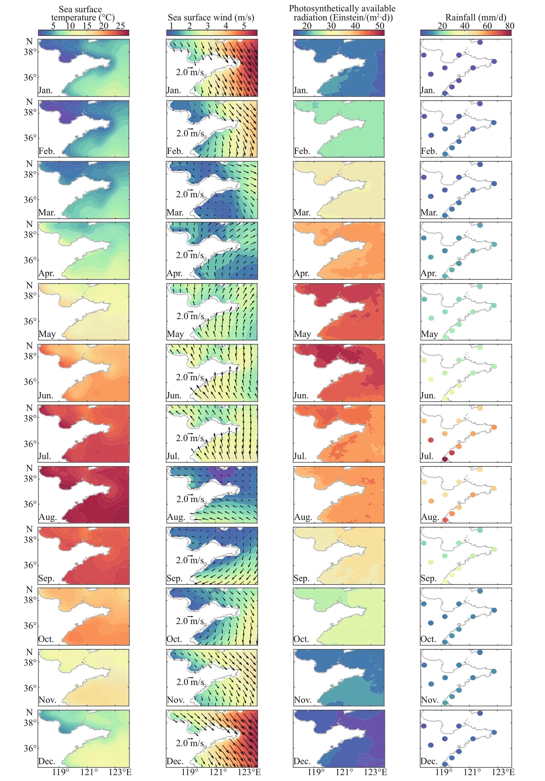
Fig.9 Climatological monthly mean sea surface temperature (°C) (first column), sea surface 10-m wind vectors (arrows;m/s) and speed (color; m/s) (second column), photosynthetically available radiation (Einstein/(m 2·d)) (third column),and land rainfall (mm/d) (fourth column) around the Shandong Peninsula
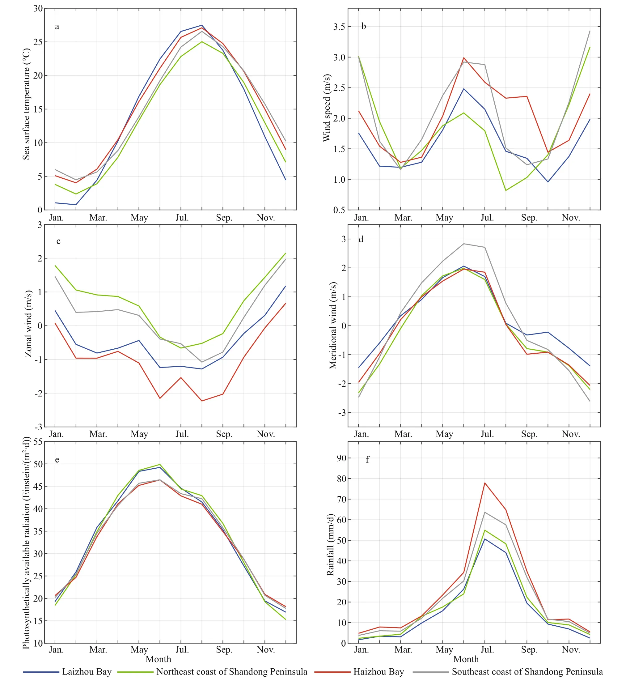
Fig.10 Climatological monthly means of sea surface temperature (°C) (a), sea surface 10-m wind speed (m/s) (b), sea surface 10-m zonal wind (m/s) (c), sea surface 10-m meridional wind (m/s) (d), photosynthetically available radiation(Einstein/(m2·d)) (e), and rainfall (mm/d) (f)
The meridional wind and photosynthetically available radiation show nearly the same seasonal variations over the four subregions. The strongest southerly wind occurs in June, while the strongest northerly wind occurs in December/January. The photosynthetically available radiation also reaches its annual maximum in June. We note that the April-May increase in the Chl-aconcentration in Haizhou Bay,Laizhou Bay, and along the northeast coast of the Shandong Peninsula (Fig.5) co-occurred with the spring-summer increase in the photosynthetically available radiation, which indicates that the increasing photosynthetically available radiation contributes positively to phytoplankton growth in spring and thus the extreme Chl-aconcentration in May in these subregions.
Therefore, the seasonal variations of the surface Chl-ain diff erent coastal regions around the Shandong Peninsula are controlled by diff erent mechanisms.Along the southeast coast of the Shandong Peninsula,the development of the Yellow Sea Cold Water and the transition of the sea surface wind from northerly winter monsoon to southerly summer monsoon result in the surface Chl-aconcentration decreasing from February to July and reaching its minimum in summer.In Laizhou Bay, Haizhou Bay, and along the northeast coast of the Shandong Peninsula, the seasonal variations of the surface Chl-aconcentration are quite possibly controlled by combined eff ects of the sea surface temperature and riverine input nutrients. In specific regions and months, sea surface winds and photosynthetically available radiation also contribute positively.
4.3 Processes related to the interannual trends of Chl- a concentration
As shown in Fig.6, the interannual trends in the surface Chl-aconcentration around the Shandong Peninsula exhibited spatial and seasonal variations,implying that the underlying dynamics also diff er among regions and seasons. To help understand the mechanisms, Fig.11 displays the interannual trends of the annual and seasonal mean values of various influencing factors around the Shandong Peninsula during the period ofinterest. These factors have quite diff erent interannual trend patterns. The sea surface temperature basically shows increasing trends, which are clearer in spring and summer seasons. In Laizhou Bay, however, the winter mean sea surface temperature displays a decreasing trend. The sea surface wind speed shows decreasing trends in winter and spring but increasing trends in summer and autumn, which are clearer in winter and autumn, respectively. Note that the decreasing wind speed in winter is attributed to the weakening northerly wind, while the increasing wind speed in autumn results from the strengthening northeasterly wind (figure not shown). The interannual trends in photosynthetically available radiation experience a more robust seasonal cycle, shifting from decreasing in winter to increasing in summer.Additionally, the photosynthetically available radiation trends in summer are above the 95%confidence level in most areas. The land rainfall shows decreasing trends over the whole Shandong Peninsula in all four seasons, most clearly in summer.The decreasing land rainfall could further result in the drastic decrease in the freshwater input to the sea due to human activities such as increasing agricultural irrigation and dam construction (Wang et al., 2017).
Around Haizhou Bay, the surface Chl-aconcentration showed significant increasing trends in winter-to-summer seasons. The increasing trends for surface Chl-aconcentration in all seasons could have resulted from the increasing trends in sea surface temperature, as warm temperatures favor phytoplankton growth. In the winter season, the weakening northerly wind could hinder the off shore spreading of the land-sourced nutrients from coastal areas of Rizhao City and contribute positively to the increasing Chl-aconcentration trend. In the summer season, the maximum increasing trend of photosynthetically available radiation occurs around Haizhou Bay and could also lead to the increasing Chl-aconcentration trend. In addition, eutrophication may be another important factor leading to the increasing Chl-aconcentration trend. Though decreasing land rainfall may reduce freshwater input to the sea, increasing nutrient concentrations have been observed during 2008-2015 in Haizhou Bay(Huang et al., 2017). The opposing trends ofland rainfall and nutrient concentrations imply that more nutrients were produced on land around Haizhou Bay and discharged into the sea over the past 16 years.
In other coastal areas, the interannual Chl-aconcentration trends were basically decreasing, most clearly in summer. The decreasing Chl-aconcentration trends coincide well with the decreasing land rainfall trends. Coincident changing trends of the surface Chlaconcentration, nutrients and land rainfall have been observed in Sishili Bay during 2003-2008 (Hao et al.,2011). The reduced land rainfall would transport fewer nutrients into the sea and result in decreasing trends for surface Chl-aconcentration.
Therefore, the increasing trends in the surface Chlaconcentration around Haizhou Bay are mainly caused by the rising sea surface temperature and increasing nutrient concentrations. The weakening northerly wind and increasing photosynthetically available radiation also contribute positively in winter and summer, respectively. In other coastal areas of the Shandong Peninsula, the decreasing trends of the surface Chl-aconcentration are mainly induced by the weakening land rainfall, which could reduce nutrient flux into the sea.
5 CONCLUSION
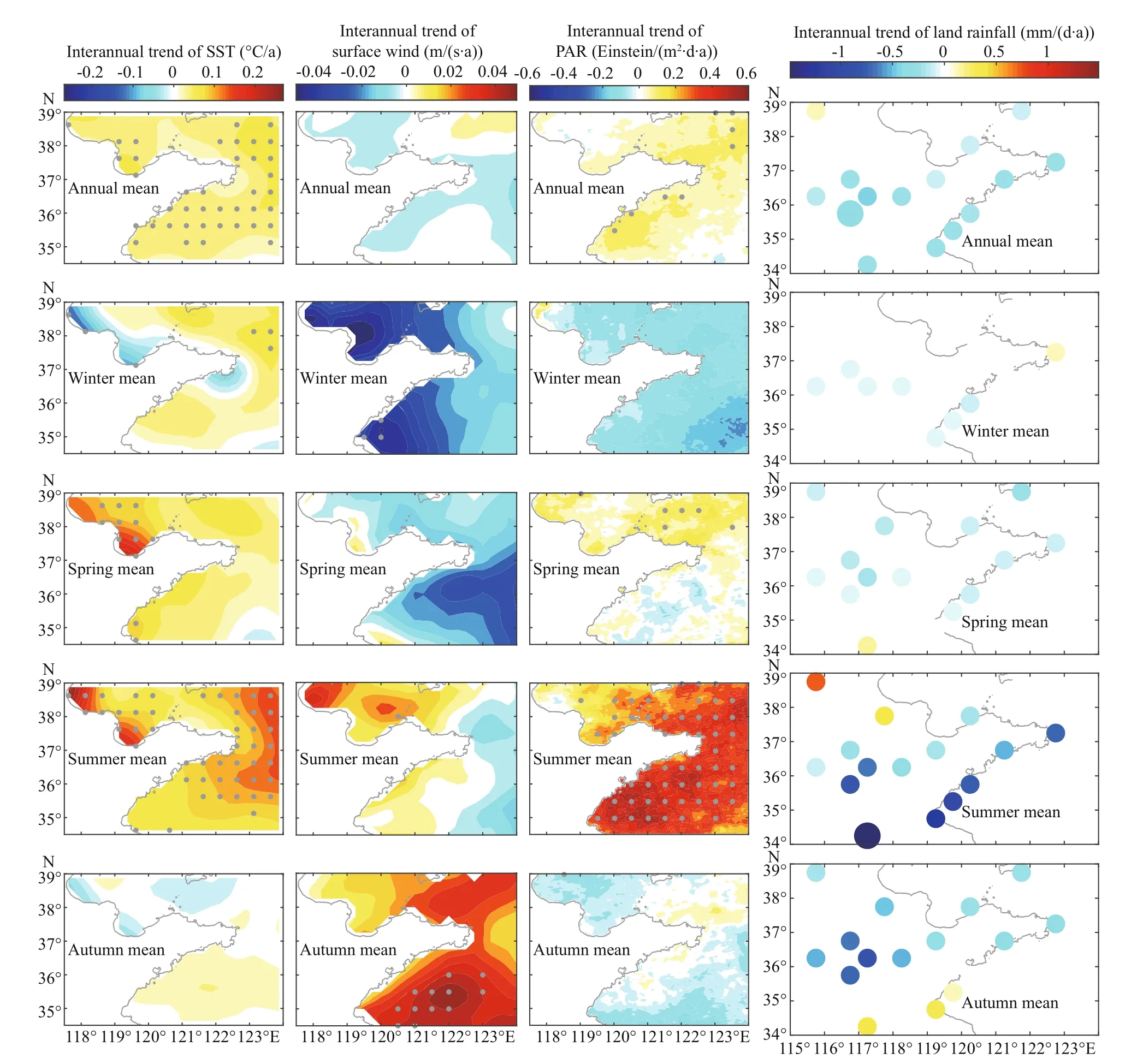
Fig.11 Interannual trends in the annual and seasonal mean sea surface temperature (SST; °C/a), sea surface wind speed (m/(s·a)), photosynthetically available radiation (PAR; Einstein/(m 2·d·a)) and land rainfall (mm/(d·a))
In the current study, the climatology and seasonal variability of surface Chl-aconcentration around the Shandong Peninsula are investigated based on 16 years (December 2002-November 2018) of satellite ocean color observations. The underlying dynamics are also discussed. The results indicate that around the Shandong Peninsula, the climatological annual mean Chl-aconcentration is higher in the Bohai Sea than in the Yellow Sea and decreases from coastal waters to off shore waters. The Chl-aconcentration pattern matches the spatial pattern of nutrients well (Yu et al.,2000; Wang et al., 2003; Lin et al., 2005; Fu et al.,2009; Gao et al., 2011). The highest Chl-aconcentration appears in Laizhou Bay, Haizhou Bay,and along the northeast coast of the Shandong Peninsula, while the lowest Chl-aconcentration occurs along the southeast coast of the Shandong Peninsula. The high Chl-aconcentration in the former three subregions is quite possibly due to the combined eff ects of the intense riverine nutrient input and long residence time caused by the concave shape of the coastline. In addition, the Bohai Coastal Current,Lubei Coastal Current, and Yellow Sea Coastal Current may also contribute to the greater levels of Chl-aconcentration observed in the northern coastal waters of the Shandong Peninsula than in the southern coastal waters. The high Chl-aconcentration in Laizhou Bay extends toward the open ocean much farther than in Haizhou Bay and along the northeast coast of the Shandong Peninsula. One of the important possible reasons is related to the sea surface wind,which blows northward in Laizhou Bay and westward in Haizhou Bay.
On the seasonal time scale, the surface Chl-aconcentration around the Shandong Peninsula shows a significant spatial variation. In the southeast coast of the Shandong Peninsula, the Chl-aconcentration is lowest throughout the year and reaches its annual maximum in winter and its minimum in summer.From February to July, the surface Chl-aconcentration decreases with the development of the Yellow Sea Cold Water and the transition of the sea surface wind from northerly winter monsoon to southerly summer monsoon. The surface Chl-aconcentrations in Laizhou Bay, Haizhou Bay and along the northeast coast of the Shandong Peninsula show similar seasonal variations to those in the Bohai Sea (Zhang et al., 2017) but are nearly opposite to those in the southeast coastal waters. They exhibit their annual maxima in August/September. This type of seasonal variation is quite possibly due to the combined eff ects of the sea surface temperature and river discharges,which reach their annual maxima in July-September.In addition to favoring the rapid growth of phytoplankton, a high sea surface temperature also induces strong ocean stratification along with weak sea surface winds, large quantities of freshwater by river discharge and rainfall over the ocean. The ocean stratification restricts the nutrients input by rivers within the thin surface layer. In Haizhou Bay, the westward zonal wind also tends to restrict nutrients from extending eastward away from the coast in summer. High nutrient concentrations facilitate the phytoplankton bloom that occurs in late summer/early autumn, thus leading to the annual maximum Chl-aconcentration. In addition, the photosynthetically available radiation also contributes positively to the phytoplankton growth in spring.
There are significant increasing trends in the surface Chl-aconcentration over a large area around Haizhou Bay in winter-to-summer seasons. These increasing trends of Chl-aconcentration are mainly caused by the rising sea surface temperature and increasing nutrient concentrations. In other coastal areas of the Shandong Peninsula, the surface Chl-aconcentration shows decreasing trends (below the 95% confidence level), which are clearest in summer.Decreasing Chl-aconcentration trends are mainly induced by the weakening land rainfall, which could reduce the nutrient flux into the sea.
This study highlights diff erent dynamics for the climatology and seasonal variability of the surface Chl-aconcentration around the Shandong Peninsula in diff erent regions. In the future, continuous observations and numerical simulations of physicalbiogeochemical parameters and human activities with high resolution both in space and time are still needed to advance our understanding of the coupled physicalecological-human interactions over adjacent Chinese seas at multiple time scales.
6 DATA AVAILABILITY STATEMENT
The level 3 monthly composite Chl-aconcentration and photosynthetically available radiation retrieved by MODIS/Aqua are downloaded from the Asia-Pacific Data-Research Center of the International Pacific Research Center (http://apdrc.soest.hawaii.edu/las/v6/dataset?catitem=12619) and the National Oceanic and Atmospheric Administration (NOAA)OceanWatch-Central Pacific (https://oceanwatch.pifsc.noaa.gov/thredds/catalog.html). The level 4 high resolution daily sea surface temperature data set prepared by the Operational Sea Surface Temperature and Sea Ice Analysis system is downloaded from Asia-Pacific Data-Research Center of International Pacific Research Center (http://apdrc.soest.hawaii.edu/data/data.php). The optimum interpolation sea surface temperature version 2 data set is downloaded from the NOAA National Centers for Environment Information (https://www.ncei.noaa.gov/data/seasurface-temperature-optimum-interpolation). The ERA5 sea surface winds are downloaded from the ECMWF website (https://cds.climate.copernicus.eu/cdsapp#!/home). The land rainfall data set is downloaded from the Asia-Pacific Data-Research Center of the International Pacific Research Center(http://apdrc.soest.hawaii.edu/data/data.php).
 Journal of Oceanology and Limnology2021年4期
- Journal of Oceanology and Limnology的其它文章
- Numerical study of the seasonal salinity budget of the upper ocean in the Bay of Bengal in 2014*
- Study on evaluation standard of uncertainty of design wave height calculation model*
- A fast, edge-preserving, distance-regularized model with bilateral filtering for oil spill segmentation of SAR images*
- A Gaussian process regression-based sea surface temperature interpolation algorithm*
- Sources of sediment in tidal flats off Zhejiang coast, southeast China*
- Characteristics of dissolved organic matter in lakes with diff erent eutrophic levels in southeastern Hubei Province,China*
