甘肃省1961―2018年降水量时空分布与变化研究
郭嘉兵,李金文,马金珠,俞巧
甘肃省1961―2018年降水量时空分布与变化研究
郭嘉兵,李金文,马金珠*,俞巧
(兰州大学 资源环境学院/西部环境教育部重点实验室,兰州 730000)
【】研究甘肃省降水量时空分布与变化,获得在暖湿趋势下甘肃省降水量变化特征。选取甘肃省1961―2018年59个气象站降水量为基础数据,采用指数、小波分析、M-K检验等方法对甘肃省降水时空分布特征、降水周期、突变年份及趋势变化进行分析。甘肃省年降水量在空间上自东向西呈现逐渐减少的规律,降水量年内分配不均匀程度逐渐增加;在时间上,甘肃省存在28、22、12、5 a降水变化周期,其中以28 a周期震荡最强;降水量突变主要发生在20世纪60年代中期、70年代初期、80年代中期以及90年代初期。甘肃省西部地区的降水量整体呈增加趋势,增加率为0.45 mm/a,中部、南部、东部地区呈下降趋势,下降率分别为-0.82、-0.81、-0.93 mm/a。甘肃省近60 a降水量的长时间尺度周期显著,突变年份与极端降水及干旱事件相对应,西部与中东部地区降水量变化趋势存在较大差异,20世纪90年代后,甘肃省降水量显著增加。
甘肃省;降水量;时空分布;趋势分析
0 引言
【研究意义】降水是水循环中最重要的气象因子之一。降水时空变化能够反映地区气候与生态环境的变动,对人类的生活生产具有重要意义[1-2]。近年来,气候异常导致我国降水量发生变化,并引起了人们的广泛关注。
【研究进展】有研究表明,1979―2018年我国年均降水量显著增长,且有进一步增长的趋势[3]。气候异常变化和人类活动加剧,造成我国北方地区降水时空分布也发生了变化[4]。20世纪60年代以来,西北地区的年降水量呈微弱上升趋势,平均每年上升0.17 mm;具有向暖湿变化的倾向,但西北地区东部(如陕西西部,宁夏及甘肃东部)降水量呈现明显下降趋势[5-6]。王燕等[7]研究了1965―2001年甘肃省降水特征,甘肃省降水自西北向东南呈增加趋势,降水量主要集中在夏季,并指出甘肃省降水量在33 a尺度上呈减少趋势,4 a周期比较显著。王红桃等[8]提出甘肃省西北地区气候向暖湿转变,而东南部则向暖干转变,在1967―2008年间,西北部降水量有略微的增加,东南部明显减少。李栋梁等[9]针对甘肃河东地区降水量周期变化进行研究,认为甘肃河东年降水量存在显著的3 a和9 a周期。
【切入点】上述研究成果主要集中在甘肃省降水量的分布趋势和周期研究,然而近些年西北地区降水增多趋势的降水序列略微不足,此外,关于甘肃省降水量整体周期分布时间不明确,对于降水量的变化趋势描述的时间尺度较大,且没有详细分析降水量减少地区的差异性。【拟解决的关键问题】因此,针对以上问题,本文以气候类丰富的甘肃省为研究区,对比不同气候类型区降水量变化的异同点。拟选取甘肃省1961―2018年59个气象站降水量为基础数据,采用指数、小波分析、M-K检验等方法对1961―2018年甘肃省降水时空变化进行研究,这对当地生态环境以及灾害预报具有重要意义,以期为今后本地区气象、生态及水文等方面研究提供科学的依据。
1 材料与方法
1.1 研究区概况
甘肃省地处我国中部偏西,东西蜿蜒1 600多km,气候类型多样,从南向北包括了亚热带季风气候、温带季风气候、温带大陆性气候和高原高寒气候等气候类型[10-11]。秦大河[12]指出甘肃省是青藏高原、黄土高原以及蒙古高原三大地形的汇集区,不仅是我国大陆的地理中心,还是西北干旱区、东部季风区、青藏高原高寒气候区三大气候带交汇地,进而甘肃省具有气候变化敏感、生态环境脆弱等特点。
拟采用甘肃省59个气象站1961―2018年的降水资料(数据来源于中国国家气象科学数据中心http://data.cma.cn)为基础数据,并结合气候分区及年降水量,将甘肃省分为4个分区(Ⅰ:西部干旱地区、Ⅱ:中部半干旱区、Ⅲ:南部半湿润区、Ⅳ:东部半湿润区)[13],进而分析其降水量的时空分布与变化。
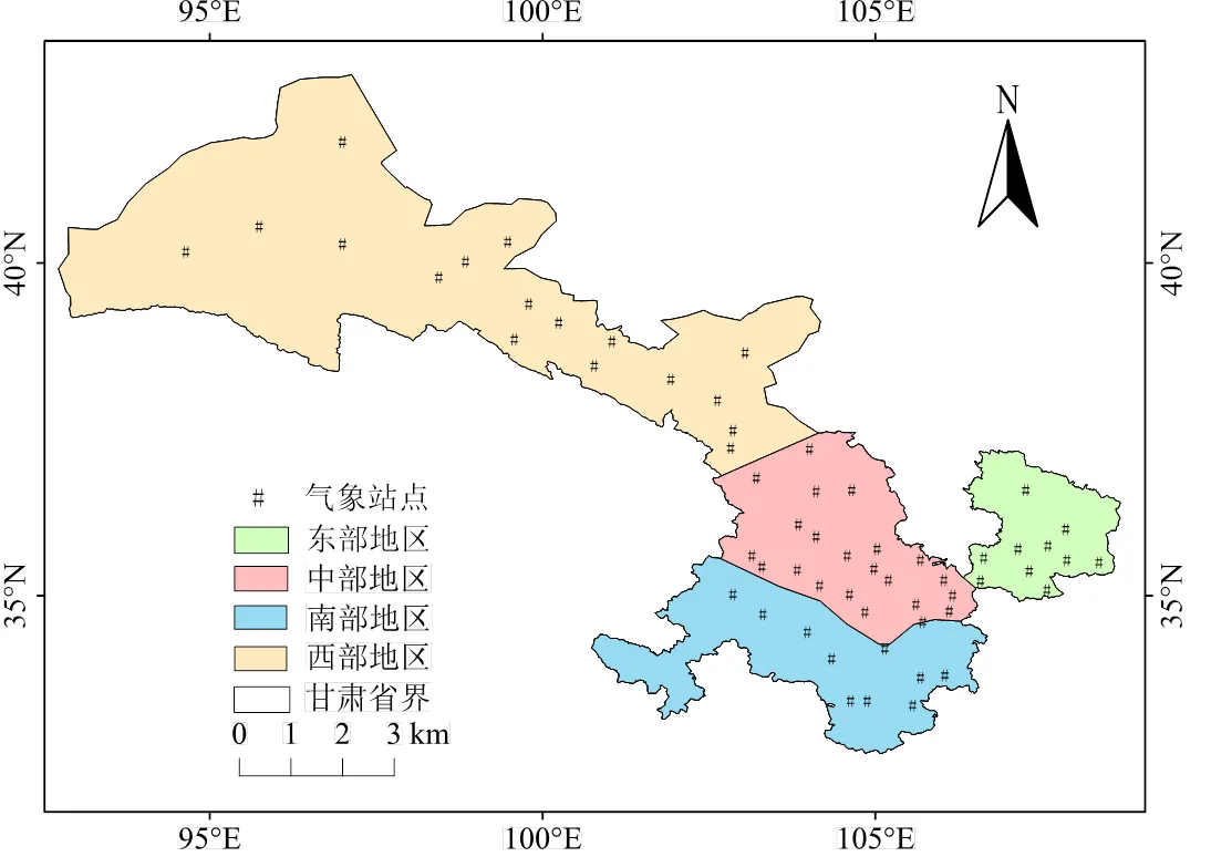
图1 甘肃省气象站点分布
1.2 研究方法
采用降水集中指数[14](,Precipitation Concentration Index)、M-K检验[18-20]、小波分析[15]研究降水的分布和变化特征。采用滑动检验[21]研究降水量的突变。
2 结果与分析
2.1 降水量空间分布及年内分配特征
通过计算甘肃省降水量各项指数,并利用ArcGIS技术绘制了等值线图(图2)。从图2(a)可以看出,甘肃省年均降水量在空间上呈现自东向西逐渐减少的规律,在敦煌、瓜州地区形成了降水的极低值,敦煌地区地处干旱区,年平均降水量仅为41.31 mm;南部、东部等地区(如康县、徽县、正宁等地)属于半湿润区,年均降水量均大于700 mm,其中康县达到了773.82 mm,为全省最大值,东西两地区降水量相差近20倍,降水量变化的一个重要因素是受到西风势力影响[21]。中部地区自兰州、乌鞘岭向西到张掖的降水量东西变化较小,南北变化大,靠近南部沿祁连山一带降水量较多。
根据指数等值线图(图2(b))和v值(变异系数)等值线图(图2(c))可分析甘肃省各地降水年内分布的均匀性。各地区值与v值自东向西逐渐增加,年内分配不均匀程度增加。值大于20的地区占全省的22%,主要分布在敦煌、瓜州、玉门镇等地,该地区由于地处干旱区,降水年内分布极其不均匀;其余地区的指数介于10~20之间,降雨均呈季节性分配,符合北方地区降水特征[22]。
西部地区夏季(6―8月)降水量占全年的58%,秋冬季节(9月―次年2月)仅占全年降水的23%;甘肃南部半湿润区夏季降水占全年的48%,秋、冬季占全年的28%。相较于西部干旱区,东、南部地区降水年内分布较均匀(表1)。
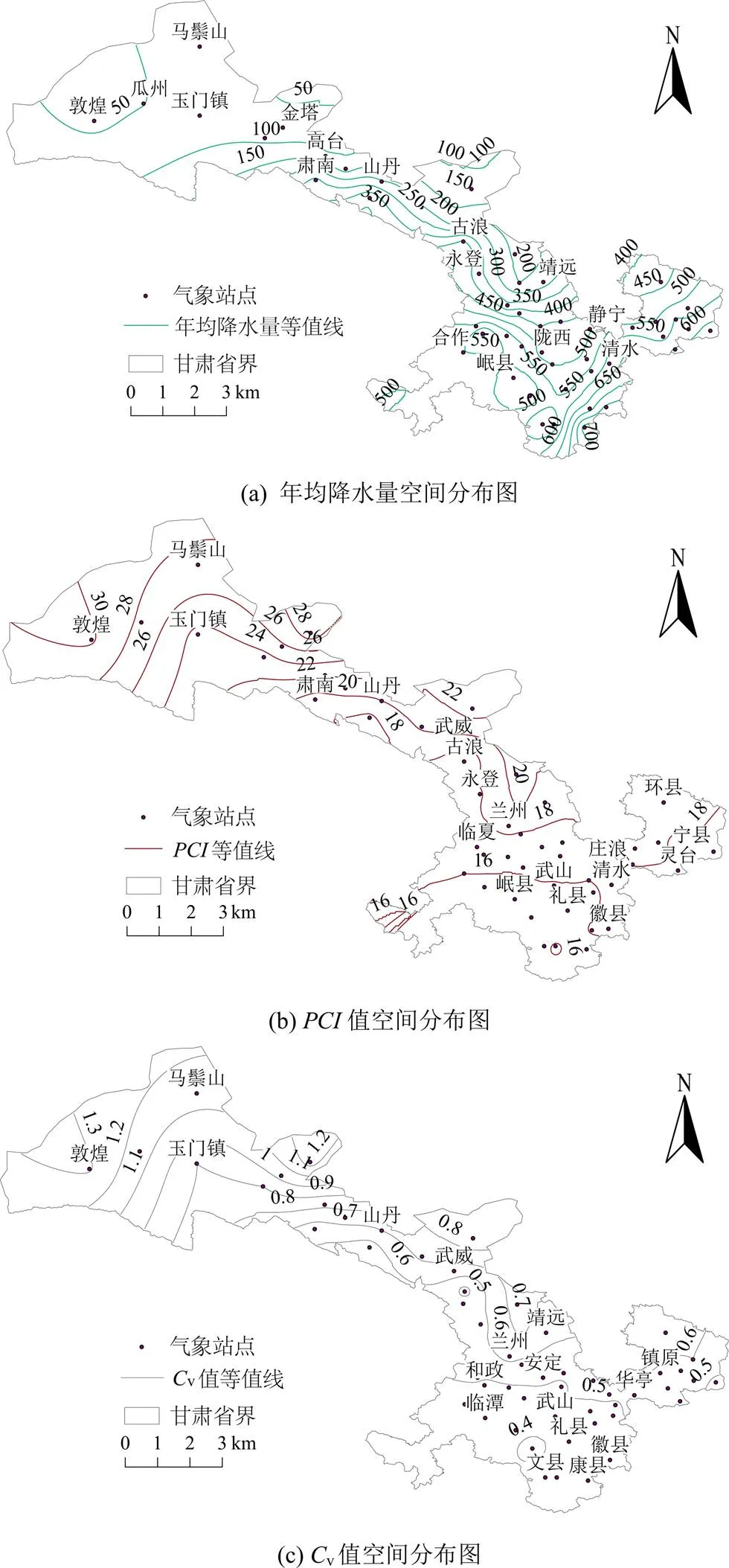
图2 降水指标空间分布图

表1 各分区降水年内分布
2.2 降水周期分析
采用小波分析判断甘肃省4个地区的降水量周期的周期变化,通过Matlab命令窗口实现,进而绘制小波变换系数实部变化图(图3)。甘肃省降水量在研究期内存在28、22、12、5 a的周期变化。
甘肃省西部地区年降水量有10~32、20~32、12~7 a尺度的周期变化,中部地区有17~32、8~15、3~7 a时间尺度的周期变化。东部与南部地区具有相似的周期变化,有18~32、9~17 a时间尺度。结合小波系数的模值分析,西部地区10~32 a时间尺度模值最大,该时间尺度能量最强、周期最显著,但分布具有局部性(在2005年之后);20~32 a时间尺度能量较弱,主要分布在20世纪60年代,12~17 a时间尺度周期性不显著。中部地区17~32 a周期性最显著,主要分布在20世纪60、70年代,以及2010年以后;8~15 a时间尺度能量相对较弱。南部、东部地区周期分布相似,18~32 a周期能量最强,周期性最明显,主要分布在20世纪60―80年代以及2005年以后。甘肃省中、南、东部地区降水量具有相近的周期变化,而西部由于降水量的分布特性与东部差异较大,周期性有一定偏差。
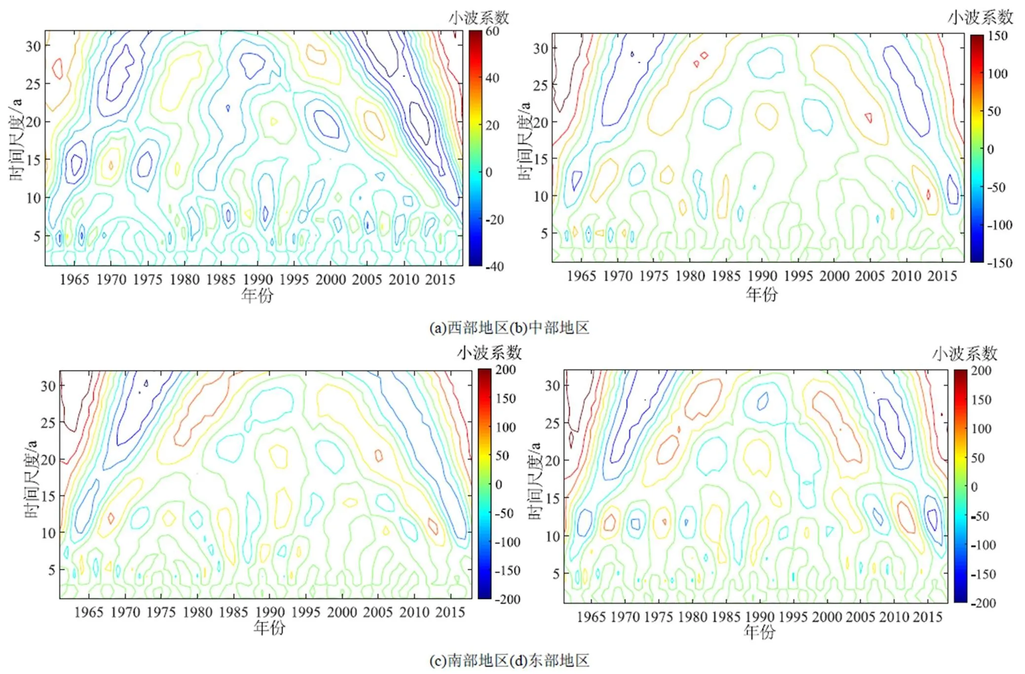
图3 甘肃省小波变换系数实部变化
甘肃各地区小波方差图存在4个明显峰值(图4),其中西部地区:28、21、14、7 a;中部地区:28、22、12、5 a;南部地区:28、22(不显著)、12、4 a,东部地区:28、22、12、4 a。各个地区小波方差图的最大峰值都对应28 a的时间尺度,说明在28 a周期震荡最强,是降水量变化的第一主周期,同时还存在第二、第三、第四主周期。
2.3 降水突变及趋势分析
2.3.1 突变检验
采用M-K检验法对甘肃省降水量突变年份进行趋势检测,表2结果显示M-K突变检验结果中与统计量的交点比较集中,均通过了0.05的显著性检验。西部地区突变年份为2001、2003、2004年,中部、南部地区突变年份主要集中在1963、1965、1969、1970年左右,东部主要突变在1962、1963、1965年和1968年。中部、南部与东部地区的突变年份有一定的相似性,主要是这些地区属于季风气候区,受到相同季风的影响,而与西部地区主要受到西风环流的控制,所以西部与东南部地区的突变年份有所差异。
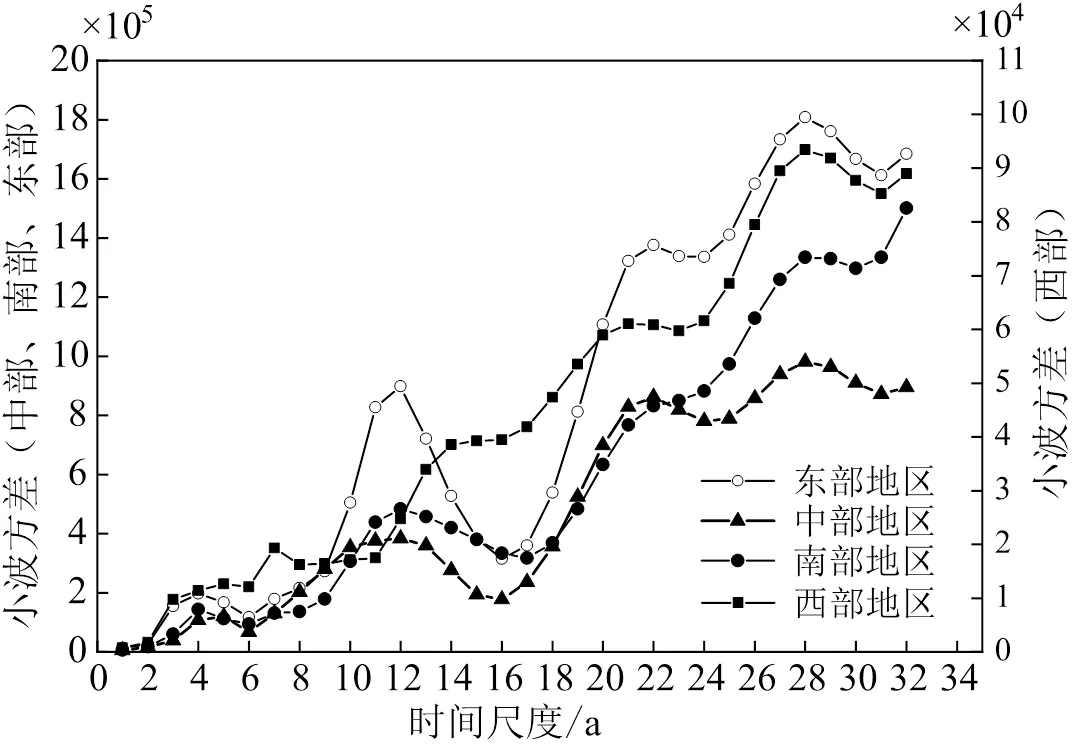
图4 小波方差

表2 M-K突变检验结果
通过对M-K突变检验结果分析,检验结果不够全面,西部地区集中在21世纪以后,中部南部地区主要集中在20世纪60年代到70年代,故采用滑动检验方式进行进一步的检测突变点(表3)。中部、南部、东部地区比较接近,中部主要突变年份有1972、1982、1985、1993、1997年等,西部地区与东南地区略有差异。通过滑动检验,发现结果与M-K检验有所差距,滑动检验检测出的突变年份比M-K突变更为广泛、全面,具有一定代表性。

表3 滑动t检验结果
注 *表示未通过0.05显著性检验。
2.3.2 趋势分析
通过对M-K趋势检验得到的甘肃各地区值及年降水变化分析,结果发现甘肃省西北干旱区的降水量整体呈增加趋势,增加率为0.45 mm/a,且通过了99%的置信度检验(表4,图5);中部、南部和东部地区的降水量呈下降趋势,下降率分别为-0.82、-0.81、-0.93 mm/a,其中南部和东部地区结果未通过置信度检验。

表4 趋势分析结果

图5 甘肃省各地区年降水量变化
在20世纪90年代,甘肃省降水量发生了较大的变化(图5),20世纪90年代以前,中部、南部、东部地区降水量呈下降趋势,其中南部、东部在20世纪90年代达到最低值,西部地区除外。在20世纪90年代后,各地区降水量均呈上升趋势,其中东部地区上升趋势最为明显,上升速率为3.74 mm/a。
3 讨论
有学者发现西北干旱区降水量在1961―2013年呈增湿趋势[23-24]。本研究也发现甘肃省降水量整体呈上升趋势,且升速率较大。甘肃西部属于非季风区,受到西风气流的控制,徐利岗等[4]研究表明在20世纪80年代以后,北方地区的水平风场发生变化,自贝加尔湖南下的气流以及从东西伯利亚来的东北风增强,导致了北方荒漠区降水发生了变化。还有研究成果认为降水增加还有一部分因素是受到厄尔尼诺现象的影响[25]。上述分析中表明乌鞘岭至张掖一带,降水量东西变化小,南北变化大,是因为该区域北部祁连山脉,阻隔了来自西南地区的水汽,此外,由于北部巴丹吉林沙漠与腾格里沙漠的存在,降水量由南向北呈现减少趋势[26]。
姚俊强等[24]研究发现在甘肃祁连山、河西走廊等西部干旱区,降水量存在较强的是12 a与22 a尺度周期。林纾等[27]在研究中得到甘肃省东南部存在有准20 a的周期,王红桃等[8]基于1967―2008年甘肃省气温和降水时空变化结果,得出甘肃西北部存在12、7、4 a的周期,东南部存在14、7、4 a的周期,这些研究成果与此次研究结果基本一致,这说明此次研究成果较为可靠。但是上述研究成果没有发现28 a震荡最强烈的周期,可能是由于研究数据序列较短,长时间尺度周期不显著,此外,20世纪90年代后,气候变化显著,尤其是极端气候事件频发,进而造成了整体的周期变化。甘肃省中部、南部、东部的降水量均在1993年发生突变,西部地区在1991年发生突变,同时,在20世纪90年代初期,降水量显著减少,突变明显,这与孔祥伟等[28]的研究结果基本一致。结合极端降水及干旱事件进行验证分析,发现滑动检验所得突变年份更具有广泛性,且与实际年份相接近[28]。本研究中所采用的M-K突变检验,易受到数据序列影响,在进行突变检测时可能存在缺陷,需要进一步完善分析方法。因此,为了更全面检验和验证突变发生年份,在进行突变检验的时候应当考虑方法的适用性,采取多种方法进行检验以得到更准确、广泛的突变年份。
4 结论
1)甘肃省年降水量空间上自东向西呈现逐渐减少的规律,v值与值自东向西逐渐增加,降水量年内分配不均匀程度随之逐渐增加。
2)在甘肃省各地区,28 a时间尺度为周期震荡最强,是降水变化的主周期,还存在有22、12、5 a的周期。甘肃省降水量突变主要发生在20世纪60年代中期、70年代初期、80年代中期以及90年代初期。
3)甘肃省西北干旱区的降水量整体呈增加趋势,增加率为0.45 mm/a;中部、南部、东部地区也呈下降趋势,下降率分别为-0.82、-0.81、-0.93 mm/a。相比较中部、南部地区,东部地区的降水量整体下降趋势更大。
[1] 徐泽华, 韩美, 张广彩, 等. 山东降水时空分布变化及其影响因素[J]. 水土保持研究, 2018, 25(3): 272-278.
XU Zehua, HAN Mei, ZHANG Guangcai, et al. Spatiotemporal distribution of the precipitation and its impact factors in Shandong Province[J]. Research of Soil and Water Conservation, 2018, 25(3): 272-278.
[2] 邵月红, 刘玲, 刘俊杰, 等. 海河流域近60a降水极值的频率分析及时空分布特征[J]. 大气科学学报, 2020, 43(2): 381-391.
SHAO Yuehong, LIU Ling, LIU Junjie, et al. Frequency analysis and its spatiotemporal characteristics of precipitation extremes in the Haihe River Basin during 1951—2010[J]. Transactions of Atmospheric Sciences, 2020, 43(2): 381-391.
[3] 杜懿, 王大洋, 阮俞理, 等. 中国地区近40年降水结构时空变化特征研究[J]. 水力发电, 2020, 46(8): 19-23.
DU Yi, WANG Dayang, RUAN Yuli, et al. Study on temporal and spatial variation characteristics of precipitation structure in China in recent 40 years[J]. Water Power, 2020, 46(8): 19-23.
[4] 徐利岗, 周宏飞, 梁川, 等. 中国北方荒漠区降水多时间尺度变异性研究[J]. 水利学报, 2009, 40(8): 1002-1011.
XU Ligang, ZHOU Hongfei, LIANG Chuan, et al. Multi-time scale variability of precipitation in the desert region of North China[J]. Journal of Hydraulic Engineering, 2009, 40(8): 1 002-1 011.
[5] 黄小燕, 李耀辉, 冯建英, 等. 中国西北地区降水量及极端干旱气候变化特征[J]. 生态学报, 2015, 35(5): 1 359-1 370.
HUANG Xiaoyan, LI Yaohui, FENG Jianying, et al. Climate characteristics of precipitation and extreme droughtevents in Northwest China[J]. Acta Ecologica Sinica, 2015, 35(5): 1 359-1 370.
[6] 商沙沙, 廉丽姝, 马婷, 等. 近54 a中国西北地区气温和降水的时空变化特征[J]. 干旱区研究, 2018, 35(1): 68-76.
SHANG Shasha, LIAN Lishu, MA Ting, et al. Spatiotemporal variation of temperature and precipitation in northwest China in recent 54 years[J]. Arid Zone Research, 2018, 35(1): 68-76.
[7] 王燕, 王润元, 王毅荣, 等. 近37年甘肃省降水特征分析[J]. 干旱区资源与环境, 2009, 23(4): 94-99.
WANG Yan, WANG Runyuan, WANG Yirong, et al. Study on the precipitation characteristics in Gansu Province[J]. Journal of Arid Land Resources and Environment, 2009, 23(4): 94-99.
[8] 王红桃, 包光, 胡亚飞. 甘肃省1967—2008年气温和降水时空变化[J]. 沙漠与绿洲气象, 2017, 11(2): 34-42.
WANG Hongtao, BAO Guang, HU Yafei. Spatiotemporal variability of temperature and precipitation during 1967-2008 in Gansu Province[J]. Desert and Oasis Meteorology, 2017, 11(2): 34-42.
[9] 李栋梁, 谢金南, 王蕾, 等. 甘肃河东年降水量的周期变化[J]. 高原气象, 2000, 19(3): 295-303.
LI Dongliang, XIE Jinnan, WANG Lei, et al. The periodly variation of annual precipitation in east Gansu[J]. Plateau Meteorology, 2000,19(3): 295-303.
[10] 武金慧, 李占斌, 沈中原. 甘肃省近50年降水量及气候变化趋势研究[J]. 干旱区资源与环境, 2008, 22(11): 24-29.
WU Jinhui, LI Zhanbin, SHEN Zhongyuan. Variation trend of precipitation and climate factors in Gansu Province for thelast 50 years[J]. Journal of Arid Land Resources and Environment, 2008, 22(11): 24-29.
[11] 费晓玲, 王毅荣. 甘肃气候生产力格局及演变[J]. 干旱区资源与环境, 2011, 25(2): 77-82.
FEI Xiaoling, WANG Yirong. Spatial pattern and regional response of climate-productivity over Gansu area[J]. Journal of Arid Land Resources and Environment, 2011, 25(2): 77-82.
[12] 秦大河. 中国西部环境演变评估. 综合卷. 中国西部环境演变评估综合报告[M]. 北京: 科学出版社, 2002.
QIN Dahe. Assessment of Environmental Evolution in Western China. Comprehensive Volume. Comprehensive Report on Assessment of Environmental Evolution in Western China[M]. Beijing: Science Press, 2002.
[13] 王红霞, 柳小妮, 李纯斌, 等. 甘肃省近42年降水量变化时空分布格局分析[J]. 中国农业气象, 2013, 34(4): 384-389.
WANG Hongxia, LIU Xiaoni, LI Chunbin, et al. Spatial-temporal distribution of precipitation in Gansu Province last 42 years[J]. Chinese Journal of Agrometeorology, 2013, 34(4): 384-389.
[14] 段亚雯, 朱克云, 马柱国, 等. 中国区域1961—2010年降水集中指数(PCI)的变化及月分配特征[J]. 大气科学, 2014, 38(6): 1 124-1 136.
DUAN Yawen, ZHU Keyun, MA Zhuguo, et al. Characteristics of precipitation concentrationindex(PCI) variations and monthly distribution of annual precipitation in China[J]. Chinese Journal of Atmospheric Sciences, 2014, 38(6): 1 124-1 136.
[15] 邵晓梅, 许月卿, 严昌荣. 黄河流域降水序列变化的小波分析[J]. 北京大学学报(自然科学版), 2006, 42(4): 503-509.
SHAO Xiaomei, XU Yueqing, YAN Changrong. Wavelet analysis of rainfall variation in the Yellow River Basin[J]. Acta Scientiarum Naturalium Universitatis Pekinensis, 2006, 42(4): 503-509.
[16] 王文圣, 丁晶, 向红莲. 小波分析在水文学中的应用研究及展望[J]. 水科学进展, 2002, 13(4): 515-520.
WANG Wensheng, DING Jing, XIANG Honglian. Application and prospect of wavelet analysis in hydrology[J]. Advances in Water Science, 2002, 13(4): 515-520.
[17] 衡彤, 王文圣, 丁晶. 降水量时间序列变化的小波特征[J]. 长江流域资源与环境, 2002, 11(5): 466-470.
HENG Tong, WANG Wensheng, DING Jing. Wavelet characteristics of the change in precipitation time series[J]. Resources and Enuironment in the Yangtza Basin, 2002, 11(5): 466-470.
[18] 杨义, 舒和平, 马金珠, 等. 基于Mann-Kendall法和小波分析中小尺度多年气候变化特征研究:以甘肃省白银市近50年气候变化为例[J]. 干旱区资源与环境, 2017, 31(5): 126-131.
YANG Yi, SHU Heping, MA Jinzhu, et al. Small and medium scale of climatic variation characteristics of Baiyin City, Gansu Province[J]. Journal of Arid Land Resources and Environment, 2017, 31(5): 126-131.
[19] XU Z X, TAKEUCHI K, ISHIDAIRA H. Monotonic trend and step changes in Japanese precipitation[J]. Journal of Hydrology, 2003, 279(1/2/3/4): 144-150.
[20] 孙朋, 金燕婷, 郭忠臣, 等. 1959—2017年安徽省夏季降水的时空变化及其影响因素研究[J]. 灌溉排水学报, 2020, 39(2): 99-106.
SUN Peng, JIN Yanting, GUO Zhongchen, et al. Study on the Summer Precipitation Spatial-temporal Variation and Influencing Factors in Anhui Province in 1959―2017[J]. Journal of Irrigation and Drainage, 2020, 39(2): 99-106.
[21] 奚圆圆, 黄晓荣, 李晶晶, 等. 四川盆地降水量变化特征分析[J]. 灌溉排水学报, 2017, 36(1): 95-101.
XI Yuanyuan, HUANG Xiaorong, LI Jingjing, et al. Analysis of variation characteristics of precipitation in Sichuan basin[J]. Journal of Irrigation and Drainage, 2017, 36(1): 95-101.
[22] 刘维成, 张强, 傅朝. 近55年来中国西北地区降水变化特征及影响因素分析[J]. 高原气象, 2017, 36(6): 1 533-1 545.
LIU Weicheng, ZHANG Qiang, FU Zhao. Variation characteristics of precipitation and its affecting factors innorthwest China over the past 55 years[J]. Plateau Meteorology, 2017, 36(6): 1 533-1 545.
[23] 刘永林, 延军平, 岑敏仪. 中国降水非均匀性综合评价[J]. 地理学报, 2015, 70(3): 392-406.
LIU Yonglin, YAN Junping, CEN Minyi. Comprehensive evaluation of precipitation heterogeneity in China[J]. Acta Geographica Sinica, 2015, 70(3): 392-406.
[24] 姚俊强, 杨青, 刘志辉, 等. 中国西北干旱区降水时空分布特征[J]. 生态学报, 2015, 35(17): 5 846-5 855.
YAO Junqiang, YANG Qing, LIU Zhihui, et al. Spatio-temporal change of precipitation in arid region of the Northwest China[J]. Acta Ecologica Sinica, 2015, 35(17): 5 846-5 855.
[25] 任朝霞, 杨达源. 近50a西北干旱区气候变化对农业的影响[J]. 干旱区资源与环境, 2007, 21(8): 48-53.
REN Zhaoxia, YANG Dayuan. Impacts of climate change on agriculture in the arid region of northwest China in resent 50 years[J]. Journal of Arid Land Resources and Environment, 2007, 21(8): 48-53.
[26] 张慧慧, 赵景波. 厄尔尼诺/拉尼娜事件对青海湖周边地区气候的影响[J]. 水土保持通报, 2013, 33(1): 146-151.
ZHANG Huihui, ZHAO Jingbo. Effects of el nino/La nina events on climate in Qinghai lake and its surrounding areas[J]. Bulletin of Soil and Water Conservation, 2013, 33(1): 146-151.
[27] 林纾, 陆登荣. 近40年来甘肃省降水的变化特征[J]. 高原气象, 2004, 23(6): 898-904.
LIN Shu, LU Dengrong. Climatic change characteristics of precipitation in Gansu Province in recent 40 years[J]. Plateau Meteorology, 2004, 23(6): 898-904.
[28] 孔祥伟, 陶健红. 近51a甘肃夏季气温和降水极端事件变化[J]. 干旱区研究, 2012, 29(6): 965-971.
KONG Xiangwei, TAO Jianhong. Change of extreme temperature and precipitation events in Gansu Province in summer in recent 51 years[J]. Arid Zone Research, 2012, 29(6): 965-971.
Spatiotemporal Variation in Precipitation over Gansu Province from 1961 to 2018
GUO Jiabing, LI Jinwen, MA Jinzhu*, YU Qiao
(School of Resources and Environment, Lanzhou University/ Key Laboratory of Western Environment Ministry of Education, Lanzhou 730000, China)
【】Spatiotemporal variation in precipitation is the consequence of a combined impact of regional climate and ecological environment. Global climate change over the past few decades has resulted in a change in precipitation pattern in many regions including Gansu, a province in China characterized by co-existence of arid climate in the west, monsoon climate in the east and alpine climate in the Qinghai-Tibet plateau. This combination makes the ecological and environment systems in Gansu fragile and susceptible to climate change.【】The purpose of this work is to analyze the spatial change in precipitation over the province since 1961 as sell as the underlying mechanisms, especially the impact of global warming and anthropogenic activities.【】Precipitation measured from 59 meteorological stations from 1961 to 2018 across the province was analyzed using theindex, the wavelet analysis, MK test and other methods, from which we calculated its characteristics including period of precipitation, abnormal changes as well as trends in its spatiotemporal variation using the slidingtest.【】The annual precipitation decreased from the east to the west across the province. The intra-annual variation in the precipitation had increased from 1961 to 2018. We identified five periods in the precipitation: 28 years, 22 years, 12 years and 5 years, with the 28 year period most identifiable. Abrupt change in precipitation occurred in the middle 1960s, the early 1970s, the middle 1980s and the early 1990s. Precipitation in the west of the province had been increasing at 0.45 mm/a, while that in the central, south and east parts of the province had been in decline at 0.82 mm/a, 0.81 mm/a and 0.93 mm/a, respectively, until 1990s. But since the 1990s, the precipitation in all regions over the province has been in increase, especially in the east area where the precipitation has been increasing at 3.74 mm/a.【】The precipitation in Gansu province over the past 60 years showed periodic and had witnessed both extreme rainfalls and droughts. There is a distinguishable difference in temporal change in precipitation between the west and central-east. Since the 1990s, the precipitation in the province has increased significantly. Our results have important implications for improving ecosystem services and alleviating disasters induced by climate changes, apart from providing a baseline database for meteorological, ecohydrological researches in this region and beyond.
Gansu province; precipitation; spatiotemporal variation; trend analysis
P426
A
10.13522/j.cnki.ggps.2020479
1672 - 3317(2021)03 - 0142 - 07
郭嘉兵, 李金文, 马金珠, 等. 甘肃省1961―2018年降水量时空分布与变化研究[J]. 灌溉排水学报, 2021, 40(3): 142-148.
GUO Jiabing, LI Jinwen, MA Jinzhu, et al. Spatiotemporal Variation in Precipitation over Gansu Province from 1961 to 2018[J]. Journal of Irrigation and Drainage,2021, 40(3): 142-148.
2020-08-22
中央高校基本科研业务费专项资金项目(lzujbky-2020-kb54)
郭嘉兵(1996-),男。硕士研究生,主要从事水文与水资源研究。E-mail: 479821643@qq.com
马金珠(1968-),男。教授,主要从事同位素水文学与包气带水文学研究。E-mail: jzma@lzu.edu.cn
责任编辑:陆红飞

