
Modeling and predicting dengue fever cases in key regions of the Philippines using remote sensing data
2019-02-27 05:24:58MariaRuthPinedaCortelBenjieClementePhamThiThanhNga
Maria Ruth B. Pineda-Cortel, Benjie M. Clemente, Pham Thi Thanh Nga
1Department of Medical Technology, Faculty of Pharmacy, University of Santo Tomas, Manila City, Philippines
2Research Center for the Natural and Applied Sciences, University of Santo Tomas, Manila City, Philippines
3The Graduate School, University of Santo Tomas, Manila City, Philippines
4Vietnam National Space Center, Hoang Quoc Viet, Hanoi, Vietnam
5Vietnam Academy of Science and Technology, Hoang Quoc Viet, Hanoi, Vietnam
Keywords:Dengue fever Climate change Remote sensing data Autoregressive Integrated Moving Average models
ABSTRACT Objective: To correlate climatic and environmental factors such as land surface temperature,rainfall, humidity and normalized difference vegetation index with the incidence of dengue to develop prediction models for the Philippines using remote-sensing data. Methods: Timeseries analysis was performed using dengue cases in four regions of the Philippines and monthly climatic variables extracted from Global Satellite Mapping of Precipitation for rainfall,and MODIS for the land surface temperature and normalized difference vegetation index from 2008-2015. Consistent dataset during the period of study was utilized in Autoregressive Integrated Moving Average models to predict dengue incidence in the four regions being studied. Results: The best-fitting models were selected to characterize the relationship between dengue incidence and climate variables. The predicted cases of dengue for January to December 2015 period fitted well with the actual dengue cases of the same timeframe. It also showed significantly good linear regression with a square of correlation of 0.869 5 for the four regions combined. Conclusion: Climatic and environmental variables are positively associated with dengue incidence and suit best as predictor factors using Autoregressive Integrated Moving Average models. This finding could be a meaningful tool in developing an early warning model based on weather forecasts to deliver effective public health prevention and mitigation programs.
1. Introduction
Climate change is one of the most significant environmental changes the human race is currently facing today[1]. Several studies have shown that climate change has already affected human health and its impact is continuously increasing[1-4]. The relationship between climatic factors and disease manifestations was also identified. Most notably, the strongest associations were seen between climate change variables and vector-borne diseases like dengue[5-7]. The anticipated variations in global temperature,rainfall, and humidity due to climate change will greatly affect the biology and ecology of vectors and subsequently increase the risk of disease transmission[8-10].
Dengue fever is considered one of the most important arboviral diseases in tropical and sub-tropical countries transmitted to humansviamosquito bites[11,12]. According to the report of the World Health Organization in 2017, approximately 3.9 billion people are highly at risk for dengue, and an estimated 390 million infections occur annually with about 96 million having clinical manifestations[13].As per the Epidemiology Bureau of the Department of Health,every year, thousands of cases have been reported in the country;the prevalence of dengue escalated from approximately 46 300 in 2008 to more than 131 000 in 2017. The blood-feeding cycle of the mosquitoes is influenced by some factors such as climate[14].In countries where vector life-cycle is highly domiciliary, climate significantly helps in the survival of infected mosquitoes[15].
It has been predicted that the endemic range of dengue infection will expand geographically due to the threat of global warming[3].The change in climate variables affects three components in dengue transmission, namely, the pathogen, the vector, and the mode of transmission[16]. For instance, ambient temperature increases the rate of replication of the dengue virus (pathogen) within the vector and also shortens its extrinsic incubation period favoring a faster transmission from one host to another[17]. A 2 ℃ rise in temperature would significantly lengthen the lifespan of the vector mosquitoes and would allow the rapid rate of reproduction and activity. This also shortens the incubation time of larva, resulting in an increased capacity of offspring production and subsequently increasing the transmission potential and incidence of dengue fever[17,18].Precipitation and humidity also play a vital role in the prevalence of dengue fever. These factors provide a conducive habitation for the aquatic stages of the mosquito life cycle, thereby, increasing vector density. The effects of precipitation and humidity on available water resources may aid in regulating the population size and behavior of the mosquito giving strong impacts on vector distribution[19].
Several studies were conducted to establish the link between dengue and climatic variables and to forecast dengue outbreak and occurrence based on this relationship. Studies used different approaches such as statistical and mathematical models, spatial analysis, and numerous indices to demonstrate the relationship between climatic factors and dengue occurrence[20]. For instance,Chen and Hsieh developed a vector-host dynamic model that focuses on temperature-dependent entomological parameters to determine the transmission dynamics of dengue fever with regards to the effects of temperature[21]. A spatial model of the socioeconomic and environmental determinant of dengue fever was also developed by Delmelleet al.to permit better detection of high-risk areas and to fortify the resiliency of the population[22]. An association between dengue fever incidence and meteorological factors in Guangzhou, China from 2005-2014 was tested using Distributed Lag non-linear models and Generalized Estimating Equations models with piecewise linear spline functions in an attempt to provide an early warning and time control to predict the likely potential of climate change on dengue occurrence[23]. Liet al.and Hiiet al.used different methods of time series Poisson analysis,generalized additive model approach and a multivariate regression model, respectively, to develop a dengue fever model and project its incidence using climatic variables[24,25]. Wuet al.also used a time series analysis to develop a predictor model that used weather variables to forecast the occurrence of dengue fever in Taiwan.
However, Autoregressive Integrated Moving Average (ARIMA)models revealed a negative association between monthly temperature deviation, relative humidity and the incidence of dengue fever[26].Nevertheless, best prediction models for dengue may vary from one region to another due to their complexity and methodology, and their high dependence on the nature of the variables used and the type of data collected. Therefore, there is no universal model for global analysis and prediction that exists.
Monitoring and predicting the incidence of dengue may aid in the early public health mitigations to minimize its morbidity and mortality. In this study, we applied the ARIMA model for dengue fever with extensive use of remote sensing data in the four selected regions of the Philippines that recorded the highest prevalence of dengue from 2008-2015. The researchers find this model the most suitable for the study because it can deal with the stochastic dependence of consecutive data and to account for auto-correlations in time-series as well as seasonality, long-term trends, and lags. To minimize the limitations of climate data coming from meteorological stations in spatial and time scales, the researchers used the most accessible remote sensing data for climate variables, namely Global Satellite Mapping of Precipitation (GSMaP) data for rainfall and MODIS LST (MOD11A2) for night and day surface temperature as a proxy for temperature. This study aims to correlate climatic factors with the incidence of dengue fever (2008-2015) to develop a predictor model that will provide a theoretical basis for scientific guidance on its prevention.
2. Materials and methods
2.1. Study site
This study was conducted in four regions of the Philippines that were identified as the areas most affected by dengue fever in 2015 based on retrospective data. Regions included are the National Capital Region (NCR), Central Luzon Region (Region Ⅲ), Ilocos Region (RegionⅠ), and CALABARZON (Region Ⅳ-A). Their combined cases account for more than half (55.7%) of the total recorded dengue cases in the entire country. Among the 17 regions of the Philippines, regions Ⅳ-A, NCR, Ⅲ, andⅠare the densest concerning population with relative percentages of 14.7%, 12.75%,11.11%, and 4.98%, respectively. These four regions belong to the largest main island of the Philippines, Luzon, which is located on the northern part of the archipelago (Figure 1) and is regarded as the political and economic center of the nation.
Because of its geographical location, the entire Philippines only experience two seasons based on rainfall volume, namely: the wet season (May to October) and the dry season (November to April).With regards to temperature, the warmest months are from March to October and the coldest months are usually recorded during November to February due to the winter monsoon.

Figure 1. Regional Philippine map.
2.2. Remote sensing data
For the researchers to extensively use remote sensing data, with the advantages of spatial coverage with high resolution and temporal availability, they utilized the GSMaP data as an alternative for surface rainfall measurement. The daily GSMaP/MVK (version 6) data[27]with a spatial resolution of 0.1×0.1 degrees were extracted and accumulated to calculate the monthly amount of rainfall. Monthly Land Surface Temperature data from MODIS LST (MOD11C3 with 0.05×0.05 spatial resolution)[28] with a 1 km spatial resolution was also used as a proxy for air temperature. In addition to climate variables, one of the most commonly used remote sensing-derived environmental variables, the normalized difference vegetation index(NDVI) from MODIS (MOD13Q1) with a 250 m spatial resolution was also used for modeling its influence on dengue. These remote sensing-based parameters were aggregated to compute for the mean monthly variable for the Philippines as presented in Figure 2.
2.3. Statistical analysis
To suit the models to the monthly incidence of dengue in the four regions by statistical “forecast” package in RStudio software, the Box-Jenkins methodology was used[29]. The gathered prevalence of dengue from 2008 to 2014 were statistically treated to develop a time series model that could project possible incidence of dengue.The recorded cases during the year 2015 were used as controls for validating the model. A natural log transformation was also used to stabilize dengue counts and avoid a non-constant variation of the cases.
The model was structured based on the standard form of the ARIMA (p,d,q)(P, D, Q)s, where p is the order of auto-regression;d, degree of differencing; q, order of moving average; P, seasonal auto-regression; D, degree of seasonal differencing; Q, seasonalmoving average; and s, seasonal period. In order to fit the logtransformed time series data without covariates, different forms of ARIMA models (different combinations of p, d, q, P, D, and Q) were tested. The best ARIMA model was selected with the lowest Akaike Information Criterion: measures the relative goodness of fit of a model across the four regions. Afterward, using the selected ARIMA components (p, q, P, Q from 0 to 2), multivariate ARIMA models were fitted with log-transformed dengue cases in relation with all the climate variables and time lags, which were chosen by their best correlation with dengue. Finally, variables withP-values that met 95% level of confidence were restrictedviabackward elimination and were included in the final model from all independent variables(rain, LSTd, LSTn, and NDVI).

Figure 2. Monthly GSMap data and LST data.
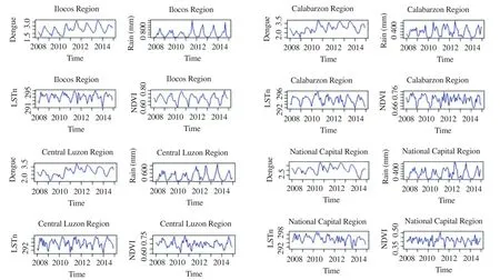
Figure 3. Seasonality and interannual variations of dengue incidence with climate and environmental variables.
3. Results
Firstly, each data from the four regions were examined to show seasonality and interannual variations of dengue incidence with climate and environmental variables (rain, LSTd, LSTn, and NDVI)during the period 2008 to 2014 as shown in Figure 3. This was done to ensure the suitability of the ARIMA model for studying monthly dengue data in each site. Histogram, an autocorrelation (ACF)of standardized residuals and Ljung-Box test were used to verify the adequacy of each model for each region similar to previous studies[30,31,32].
Figure 4 shows the time series of the prevalence of dengue fever in the four regions of study from 2008 to 2015. The highest peak for both the Ilocos Region and Central Luzon Region was observed in 2011 while the highest in CALABARZON region and the National Capital Region were recorded in 2015 and 2010, respectively. A seasonal pattern was also apparent and consistent in all four regions with incidence starting to rise in June, peaking during August, and lowest during April as seen in Figure 5.

Figure 4. Time series of dengue cases in the four studied regions.

Figure 5. Monthly mean plots for dengue in the four studied regions.
Figure 6 shows a sample of the ARIMA fitting model plot for the four regions being studied, wherein, the black line represents the reported incidence of dengue, the fitted model in red, and the blue line serves as the predicted model in 2015. A comparison of the reported incidence and model fitted using a scatter plot (Figure 7)showed the regression function with its root mean square error value for a fitted period of the 2008 to 2015 data. The final model for each region was then confirmed using Ljung-box test of the residual with no correlation for fitted data.

Figure 6. ARIMA forecasts of dengue in 2015 for the four studied regions.

Figure 7. Scatter plot of dengue and fitted for the four studied regions.
In order to validate the model, the best time series ARIMA model with final independent variables found for each region was applied to forecast incidence of dengue during January to December 2015.Figure 8 shows the comparison of the predicted dengue cases with the reported incidence for RegionsⅠ, Ⅲ, Ⅳ-A, and NCR. The results revealed that, in general, the modeled dengue at every region followed the trend of the reported incidence (Figure 8A) and showed a good linear regression with a square of correlation of 0.869 5 for the four regions (Figure 8B).
4. Discussion
Evaluating the adverse health effects related to climate change often involves analysis of different geographical and temporal scales. Development of prediction models of smaller scale by using localized parameters, such as host condition, vector density, weather parameters, and other environmental variables could accurately project the actual risk of human cases[26]. In this study, the researchers utilized different combinations of the best ARIMA model components obtained from four regions of the Philippines, namely,Ilocos Region, Central Luzon Region, CALABARZON region,and National Capital Region to investigate the influence of weather variability on dengue cases and predict future incidences. Timeseries analysis was used for this study in establishing the relationship between the changes of weather parameter, environmental factors,and the incidence of infectious diseases like dengue[33,34]. Weather variables were selected based on the best correlation of dengue with precipitation, LSTd, LSTn, and NDVI at varying time lags for 2008-2015 period data. Numerous studies have supported this claim, for example, Sanget al.revealed that the occurrence of dengue fever is positively correlated with both temperature and precipitation but with different time lags[35]. Whereas, Wanget al.showed that dengue is significantly associated with relative humidity[36].
The results of the study revealed that climate is an essential driver of dengue incidence. Temperature is significantly associated with dengue incidence, which corresponds to the result of other studies[26,37,38]. Temperature affects the potential spread

Figure 8. Dengue vs. forecasted for 2015.
of the dengue by shortening the extrinsic incubation period of the virus within its vector and the developmental cycle of the mosquitoes[39]. The Philippines is considered a tropical country with monthly minimum temperature ranging from 22 ℃ to 26 ℃year-round according to the Philippine Atmospheric Geophysical and Astronomical Services Administration giving a conducive environment forAedesmosquitoes to propagate, thereby, increasing vector density and facilitating a faster spread of the virus.
Rainfall also plays a crucial role in dengue transmission. It affects the life cycle of mosquitoes, such as mating and oviposition by providing a conducive habitat for propagation. Although this study finds rainfall as an important factor in predicting the incidence of dengue, other studies suggested that this variable did not have a significant role in the prediction of dengue fever[26,38]. The breeding sites for dengue vectors are mostly containers with water either filled manually or by rainfall. When vessels are manually filled for storage of water, vector quantity can then be basically independent of rainfall[38]. Also, excessive rainfall leading to flooding can also remove vector habitats, thus, reducing the vector population[8].
The result of validation exhibited the different performance of the ARIMA model in predicting the occurrence of dengue fever cases centered on weather factors. The correlation of the projected with the reported cases of dengue from January to December 2015 was found to be highly significant. However, it should be noted that the model was limited to the weather and environmental factors and did not consider other variables such as mosquito abundance, land cover,and population size. Furthermore, social factors such as population movement and importation of dengue fever cases were neglected in the study. Hence, further researches should be conducted that includes both socio-economic and ecological factors.
5. Conclusion
This study focused on presenting climate and environmental factors in modeling and predicting dengue fever in four regions of the Philippines. A consistent dataset of GSMaP rain, MODIS LST and NDVI for the 2008-2015 period was processed and used in ARIMA models. The identification of these variables, which were significantly correlated with dengue incidence, allowed the researchers in incorporating them in ARIMA models as external regressors. The results revealed that the remote sensing-based time series model is capable of assessing the temporal dependence of dengue incidence in the study setting. The model could well reflect the trend of dengue fever incidence in the chosen locale. Predicted dengue incidence for January to December 2015 period described well epidemics of dengue that occurred highest in the rainy season.Such a finding could be used as a guide in developing an early warning model based on weather forecasts and in planning public health prevention programs. However, eliminating the contribution on human activities pose a significant challenge in existing statistical approaches in projecting and modeling of dengue occurrence.
Conflict of interest statement
The authors declare that they have no conflict of interest.
Acknowledgement
The authors would like to take this opportunity to thank all people who have helped in the completion of this project work. To Mr.Raphael Enrique Tiongco and Mr. Joseph Basconcillo for some technical support.
Foundation project
This study is funded by the Asia Pacific Network for Global Change Research (APN) - CAF2016-RR11-CMY-Pham.
 Asian Pacific Journal of Tropical Medicine2019年2期
- Asian Pacific Journal of Tropical Medicine的其它文章
- Observational study to assess pregnant women's knowledge and behaviour related to toxoplasmosis in Essaouira province, Morocco
- Insecticide susceptibility status and resistance mechanism of Anopheles cracens Sallum and Peyton and Anopheles maculatus Theobald (Family:Culicidae) from knowlesi malaria endemic areas in Peninsular Malaysia
- Survival rate and the determinants of progression from HIV to AIDS and from AIDS to the death in Iran: 1987 to 2016
- Occurrence of Chlamydia spp. in wild birds in Thailand
- Epidemiological, prevention and control updates of yellow fever outbreak in Brazil