基于耦合协调度模型量化耕地自然质量与立地条件协同关系
钱凤魁,王卫雯,王秋兵
基于耦合协调度模型量化耕地自然质量与立地条件协同关系
钱凤魁,王卫雯,王秋兵
(1.沈阳农业大学土地与环境学院,沈阳 110161; 2.土肥资源高效利用国家工程实验室,沈阳 110161)
耕地自然质量条件与立地系统共同决定了耕地可持续的生产能力,测算二者之间的协同比例关系可为耕地资源的保护分区提供理论和方法借鉴。该文以辽宁省不同地貌区为例,通过构建不同地貌区耕地自然质量评价系统与耕地立地条件评价系统,运用耦合协调度模型量化分析二者之间的协同关系,最后依据二者之间协同关系特征建立耕地资源保护分区。研究结果表明:在辽宁省西部的丘陵地貌区、中部的平原地貌区以及东部的山地地貌区,耕地资源保护优势条件特征存在区域差异,3个地貌区耕地自然质量条件与立地条件协同关系比值分别为4:6、6:4和5:5,应遵循耕地资源条件的地域差异特征实行协同保护。在此基础上,依据耕地资源优势条件特征将辽宁省耕地区域划分为核心保护区、优势整治区以及重点调控区,并提出不同区域耕地资源差异化的利用和保护措施。该研究结果体现了不同地貌区耕地资源优势保护条件特征的差异性与规律性,可为省域尺度耕地资源的永续利用提供参考借鉴。
土地利用;模型;耕地资源;自然质量;立地条件;耦合协调度;不同地貌区;辽宁省
0 引 言
为保障粮食安全,保护优质耕地资源,中国政府建立了涵盖基本农田保护、划定以及高标准农田建设等为核心的耕地保护制度及政策体系[1-3]。随着对耕地保护研究的深入,以生产力为核心的耕地资源质量内涵不断扩展,在以土壤条件为核心的耕地自然质量条件基础上,考虑耕地资源区位、生态以及稳定性等因素的耕地立地条件作为耕地质量内涵研究越来越受到关注。19世纪80年代,美国土壤保持局建立了土地评价与立地条件分析(land evaluation and site assessment,LESA)体系,该体系分为土地评价(land evaluation,LE)与立地分析(site assessment,SA)2 部分,LE 反映了耕地的自然条件优劣;SA 则反映了耕地对社会经济条件适宜性。LESA 系统的一个最大特点就是灵活性,LESA 为不同的管理目标服务时,可以根据自己的价值取向适当调整LE 与SA 的权重比例,评价体系注重农地保护的长期稳定性和可持续生产能力[4-5]。然而,不同地貌区域耕地资源自然质量条件与立地条件优势特征差异显著,因此耕地资源评价中不仅需要差异化的指标体系构建,还应该考虑耕地资源自然质量条件与立地条件协同关系,突出其优势条件特征,为永久基本农田划定与保护以及高标准农田建 设提供参考借鉴[6-9]。
为划定和永久保护高产且稳定的耕地资源,耕地质量保护的理论、技术方法和模型研究在不断完善和延伸。其中耕地质量内涵不断扩展,其评价指标涵盖了自然质量、利用条件、时空布局以及农户行为等方面[10-17],如奉婷等从自然质量、利用条件、空间形态以及生态安全4个角度选取相关指标对耕地质量进行综合评价[10];在获取耕地资源现状数据方法方面主要依托于野外工作以及室内技术平台[18-20],如姚赫男等依托RS和GIS等技术平台评价耕地资源质量[20];构建多角度的数理统计模型是整合各类指标的关键环节,包括LESA模型[20-23],自组织神经网络模型[24],PSR模型[25],空间聚类模型以及生态风险评价模型[26-27],如钱凤魁等基于LESA体系模型对耕地资源自然质量以及立地条件进行综合评价[20-23],张锐等通过构建PSR模型对耕地资源生态功能进行评价[25]。这些研究成果丰富了耕地资源评价与保护体系,但上述研究多基于县域尺度研究,更侧重耕地评价指标层的构建研究,缺少对不同地貌特征区域的耕地自然质量条件与立地条件子系统的差异性以及协同性研究。本研究在LESA(land evaluation and site assessment)理论基础上,以辽宁省不同地貌区为研究区,分别构建耕地自然质量评价系统与立地条件评价系统,其中耕地质量评价系统以土壤等自然条件要素为主体构建,耕地立地条件评价系统以耕地利用要素与生态条件要素为主体构建,通过开展两系统之间的协同关系研究构建不同地貌区耕地自然质量与立地条件综合评价体系,并进行耕地保护的划定分区实证分析,以期为耕地资源的永久保护提供理论和方法依据。
1 研究区域与数据处理
1.1 研究区概况
辽宁省位于中国东北部,地势为自北向南、自东西向中部倾斜,呈马蹄状,山地丘陵分别位于东西两侧,平均海拔分别为800和500 m,中部为平原区,平均海拔为200 m。全省属温带大陆性季风气候,年平均气温5~11℃,年降水量400~1150 mm。2017年辽宁省耕地资源占辽宁省总面积的27.65%,80%左右的耕地资源分布于辽中平原区和辽西丘陵区,并以辽中平原区为主;林地资源占辽宁省总面积的38.47%,其分布面积由辽东山地区、辽西丘陵区到辽中平原区依次递减,其中辽东山区是辽宁省的林业基地,也是调节辽宁省自然环境状况的生态屏障。
1.2 样点选取及数据来源
1.2.1 样点选取
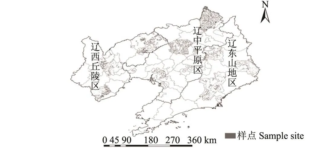
为保障耕地资源的质量和空间属性,该文依据多边形分区算法原理,以耕地资源利用等别为约束类,按照5%比例确定10 321个研究样点,其中辽西丘陵区、辽中平原区和辽东山地区的样点数分别为3 480、3 582和3 259(图1)。

图1 辽宁省不同地貌区研究样点分布示意图
1.2.2 数据来源与处理
本研究数据包括1)辽宁省1:10 000土地利用现状图,提取辽宁省耕地、生态用地、农村居民点,沟渠,交通道路以及城市边界线等基础地类信息。2)辽宁省农用地分等数据,提取研究区耕地资源农用地分等指标数据,包括土壤酸碱度、土壤有机质含量、有效土层厚度等。3)辽宁省1:50 000数字高程模型(DEM),经格式转换以及投影校正提取各研究样点坡度值。4)辽宁省不同县域的社会经济统计年鉴,获取不同县域经济概况以及粮食产量数据。
2 耕地自然质量与立地条件评价协同系统构建
2.1 耕地自然质量评价系统
耕地自然质量反映了以土壤属性为主体的耕地本底条件特征。近年来农用地质量分等成果的更新与完善工作成果为耕地自然质量评价系统建立提供了丰富和详实的理论与实践依据。该文主要参照农用地分等评价体系构建耕地自然质量评价体系[28](表1),基于多目标决策法构建不同地貌区耕地资源自然质量评价系统,并采用指标量化方法以及分级赋值规则进行耕地自然质量分值测算,计算公式如下

式中F为第个评价单元因素评价分值;f为第个评价单元第个因素评价分值;ω为第个评价单元第个因素评价权重,为评价因素个数。
为对比分析不同地貌区耕地自然质量条件特征,该文以耕地自然质量评价系统为基础计算评价单元的耕地自然质量分值,并依据-均值聚类法对所有评价单元自然质量分值进行10次迭代从而确定5个聚类中心,该方法能够分析大量数据的内在结构性,通过对不同地貌区聚类中心以及聚类案例个数进行横向对比分析发现不同地貌区自然质量的差异性及内在特征[29]。

表1 不同地貌区耕地资源自然质量评价指标与权重
注:不同地貌区指标、分级赋值标准以及权重来源于农用地分等规程(GBT28407-2012)。
Note: Indicators, grading assignment criteria and weights of different geomorphic areas are derived from Regulation for Gradation on Agriculture Land Quality (GBT28407-2012).
2.2 耕地立地条件评价系统
耕地立地条件是耕地资源稳定和可持续利用的保障条件,主要包括耕地利用条件、区位条件以及生态条件。在指标筛选、量化以及确定权重的基础上,依据多目标决策法构建不同地貌区耕地资源立地条件评价系统(同式(1)),并运用-均值聚类法对比分析不同地貌区耕地立地条件特征。
2.2.1指标筛选
耕地利用条件指标具体包括连片面积、路网密度、沟渠密度、周边农地兼容性等指标,其中周边农地兼容性表示为相邻农用地边长比例,反映耕地利用的相对稳定性;耕地区位条件指标具体包括距城镇距离,距居民点距离、距主干道距离等指标;生态条件指标采用生态兼容性、分维度等指标,生态兼容性通过相邻生态用地边长比例测算,是体现耕地生态稳定性特征指标。分维度是通过耕地斑块形状判定人为干扰程度的指标。
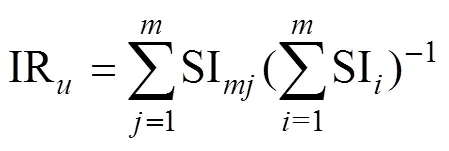
为避免指标冗余,该文基于主要信息含量法,利用累计信息含量比率IR遴选贡献率较大的指标,确定在IR-1<80%≤IR的情况下,保留满足条件的前个指标,从而确定不同地貌区立地条件评价指标体系[30-31]。计算公式如下


式中SI为指标主要信息含量;IR为累积信息含量;ω及a分别是最大方差正交旋转后因子F的方差贡献率和因子F下的指标X因子载荷。
2.2.2 指标赋值及权重
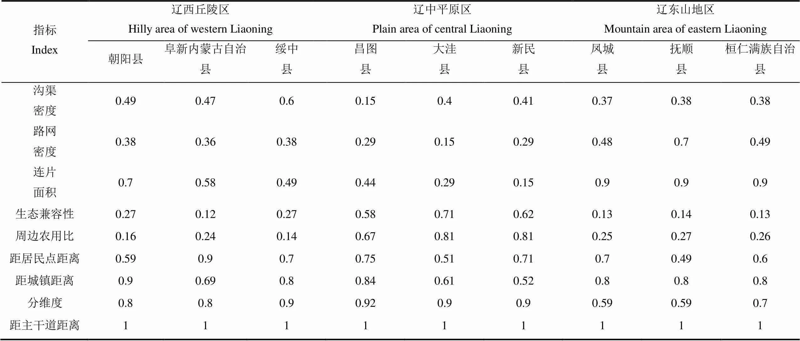
耕地产能是耕地质量高低的主要体现,评价指标特征值与粮食产能之间联系紧密。由于各指标由于量纲不同不能直接进行统计分析,为了便于对评价指标分级赋值。该文利用隶属度函数法分析指标特征值与粮食产量之间的函数关系,从而确定各个指标在不同地貌区的赋值函数,其函数类型分为戎上型与戎下型。同时运用主要信息含量法确定各指标权重,公式如下


式中X为指标标准化后的值;x为指标实际值;为指标个数;max为指标中的最大值;min为指标中的最小值。
2.3 耕地自然质量与立地条件系统协同模型
耦合度是用来分析不同地貌区耕地自然质量与立地条件系统之间的相互作用,彼此影响的程度,为反映系统的整体“功效”与“协同”效应,在耦合度值的基础上加入表示总体发展水平的成分构建耦合协调度模型[32]。依据耦合协调度理论,耦合协调度值()在0~1范围内,越趋近于1表示系统间的总体水平越高,耦合关系越协调[33]。

式中为耕地自然质量条件和耕地立地条件系统耦合协调度,为2系统之间耦合度;()表示耕地自然质量评价系统;()表示耕地立地条件评价系统,为耕地自然质量系统与立地条件系统之间比例关系。

表2 不同地貌区耕地立地条件指标信息含量
2.4 耕地自然质量与立地条件综合评价体系
LESA体系是由美国农业部提出用于耕地资源质量评价的一种常用方法,包含影响粮食产能的土壤因素,也包含影响耕地资源稳定利用的非土壤因素。依据不同地貌区耕地自然质量评价系统,立地条件评价系统以及两者的协同比例关系,基于LESA思想构建耕地自然质量与立地条件综合评价体系。

式中LESA为耕地自然质量与立地条件综合评价系统;LE等同于公式(4)中(),为耕地自然质量评价系统;SA等同于公式(4)中(),为耕地立地条件评价系统;和为耕地自然质量系统与立地条件系统之间比例关系。

表3 不同地貌区耕地立地条件指标与权重
注:函数式中为指标值;为指标分值。
Note: In the formula,is the index value;is the index score.
3 结果与分析
3.1 不同地貌区耕地自然质量与立地条件系统协同关系分析
3.1.1 不同地貌区耕地自然质量条件评价结果分析
依据耕地自然质量评价系统对不同地貌区耕地资源自然质量条件进行评价(式(1)),结果如图2所示。由图2可知,不同地貌区耕地自然质量条件评价分值在28.6~99.2分之间,辽西丘陵区、辽中平原区和辽东山地区平均分值分别为75.89、82.96和65.62分。依据-均值聚类法对比分析可知(图2),其耕地资源自然质量条件分值整体分布及峰值排序为辽中平原区>辽西丘陵区>辽东山地区,辽中平原区在耕地自然质量条件方面具有相对较大的优势,而辽西丘陵区与辽东山地区耕地自然质量条件受地形坡度及土壤有机质等因素影响较大。
3.1.2 不同地貌区耕地立地条件评价结果分析
依据耕地立地条件评价系统对不同地貌区耕地资源立地条件进行评价(同式(1)),结果显示不同地貌区耕地立地条件分值在7.84~86.57分之间,辽西丘陵区、辽中平原区和辽东山地区平均分值分别为65.08、55.77和61.62分。依据-均值聚类法对比分析可知(图2),其耕地立地条件分值分布及峰值排序为辽西丘陵区>辽东山地区>辽中平原区,辽西丘陵区和辽东山地区耕地资源立地条件优势特征突出,重点体现在耕地生态特性稳定,而辽中平原区耕地立地条件优势主要体现在利用条件特征优势突出,耕地连片度较高。

图2 不同地貌区耕地自然质量与立地条件分值聚类情况
3.1.3不同地貌区耕地自然质量与立地条件协同系统分析
为确定最为协调的耕地自然质量与立地条件系统之间的协同比例关系,即式(4)中的值,该文运用代入法,假设2个系统之间所有可能的整数值比例,即自然质量与立地条件比值从1:9到9:1,计算2个系统之间的耦合协调系数,最大的耦合协调度所对应的2个系统比值为最优的相关系数。
表4为不同地貌区耕地自然质量与立地条件耦合协调度结果,根据表4可知,不同地貌区自然质量与立地条件之间的耦合度较高且基本一致,均达到了良性共振耦合,表明2系统内部相互协同。辽西丘陵区、辽中平原区和辽东山地区的耕地资源自然质量与立地条件之间的最优协同比例关系分别为4:6、6:4和5:5。依据LESA体系模型,辽西丘陵区为LESA=0.4LE+0.6SA;辽中平原区为LESA=0.6LE+0.4SA;辽东山地区为LESA=0.5LE+0.5SA。

表4 不同地貌区耕地自然质量与立地条件耦合协调度
3.2 耕地自然质量与立地条件协同系统应用分析
省级尺度的耕地资源保护应体现其自然质量条件与立地条件特征的差异性和优势性。为验证不同地貌区协同模型的科学性与实用性,该文以辽宁省省级耕地斑块为底图,在不同地貌区分别选择5%的样点,以耦合协调度模型为基础,并运用克里金插值法对辽宁省全域耕地资源综合评价和保护分区划定。最后依据自然断点法对评价结果进行分级,并结合耕地自然质量与立地条件优势特征将全域耕地划分为3种类型区,如图3所示。分别为耕地资源核心保护区、优势整治区和重点调控区。
1)耕地资源核心保护区。该区域耕地耕地面积2.41×10⁶hm2,占辽宁省耕地资源的28.93%。该区域耕地资源平均国家利用等9.48,主要分布在辽中平原区以及辽东山地沿海区域,而辽西丘陵区分布较少。该区域地势平坦,土壤肥沃,灌溉设施完善,集中连片程度高。具有便捷的区位条件,便于机械化耕作以及现代农业发展,同时耕地距离生态涵养水源较近,具有良好的生态环境特征。该区域是高标准基本农田建设以及永久基本划定的首选区域。
2)耕地资源优势整治区。该区域耕地总面积4.38×10⁶hm2,占辽宁省耕地资源的54.14%。该区域耕地资源平均国家利用等10.16。其中辽西丘陵区的耕地具有立地条件优势,而自然质量条件较差;辽中平原区耕地资源具有优越的自然质量条件,而立地条件较差;辽东山地区耕地具有较大的生态功能价值,但破碎化问题严重。与核心保护区相比,该区域尽管耕地整体质量相对减弱,但耕地自然质量条件与立地条件差异显著,因此该区域应实施差别化管理,重点保护其优势特征的同时改善其不利条件,依据耕地资源禀赋有针对性开展土地整治以及耕地保护工作,以实现耕地资源综合质量的提升和长期稳定利用的可持续性。

图3 不同地貌区耕地资源分区
3)耕地资源重点调控区。该区域耕地总面积1.53×10⁶hm2,占辽宁省耕地资源的16.93%。该区域耕地资源平均国家利用等11.56。耕地资源主要分布于辽西丘陵与辽东山地区,辽中平原区分布较少。该区域受到地形以及种植条件限制,耕层较薄,有机质含量偏低,破碎化问题严重,耕地利用适宜性减弱。该区域既不具备良好的自然质量禀赋,也不具备优越的立地条件,实施土地整治的限制因素较多,改造较难。因此该区域建议实施生态退耕进行生态保育,或作为增减挂钩项目区域,实现其特有的耕地功能价值。

表5 耕地自然质量与立地条件综合评价结果及保护分区
4 结 论
1)不同地貌区耕地自然质量条件评价分值在28.6~99.2分之间,总体表现为辽中平原区>辽西丘陵区>辽东山地区,辽中平原区耕地资源自然质量条件整体较优,辽西和辽东地区耕地资源自然质量条件差异较大,主要限制因素为坡度及有机质。耕地立地条件分值在7.84~86.57分之间,总体表现为辽西丘陵区>辽东山地区>辽中平原区,表明辽西丘陵区耕地资源立地条件特征优势突出,耕地具有良好的生态保护特性。
2)辽西丘陵区、辽中平原区和辽东山地区的耕地自然质量条件与立地条件耦合度最大值分别为0.83、0.82和0.83,对应最优的协同比例关系为4:6、6:4和5:5。构建不同地貌区耕地自然质量与立地条件综合评价系统,其中辽西丘陵区为LESA=0.4LE+0.6SA;辽中平原区为LESA=0.6LE+0.4SA;辽东山地区为LESA=0.5LE+0.5SA。该系统体现了不同地貌区耕地资源自然质量条件与立地条件之间的差异化特征。
3)依据不同地貌区耕地自然质量与立地条件综合评价结果将全域耕地划分3种类型区域。一是耕地资源核心保护区,占28.93%,平均国家利用等9.48。耕地自然质量与立地条件特征优势显著,可作为高标准基本农田建设和永久基本农田划定的首选区域;二是耕地资源优势整治区,占54.14%,平均国家利用等10.16。耕地资源自然质量或立地条件差异较大,存在一定耕地利用的限制因素,可开展耕地资源综合整治,提升耕地综合条件优势;三是耕地资源重点调控区,占16.93%,平均国家利用等11.56。耕地资源自然质量与立地条件相对较差,耕地资源限制因素较多,耕地整治难度大,建议实施生态退耕、增减挂钩等措施,提升耕地资源有效利用途径。
本文采用耦合协调度模型量化了不同地貌区耕地自然质量与立地条件协同关系,体现了耕地资源自然质量条件与立地条件之间的区域差异化特征。然而耕地资源具有多功能性特征,在耕地立地条件指标时,应精细设计耕地资源的不同功能指标,能够既保障耕地资源对农业用途的适宜性,又保障耕地资源利用的永久稳定性。
[1] 赵珂慧. 浅谈中国耕地保护法律制度[J]. 法制博览, 2017(1):246. Zhao Kehui. The legal system of cultivated land protection in China[J]. Legality Vision, 2017(1):246. (in Chinese with English abstract)
[2] 钱凤魁,王卫雯,张靖野,等. 近30 a基本农田领域研究态势的可视化分析[J]. 自然资源学报,2017,32(12):2160-2170. Qian Fengkui, Wang Weiwen, Zhang Jingye, et al. Visual analysis of research situation in the basic farmland field from 1986 to 2015[J]. Journal of Natural Resources, 2017, 32(12): 2160-2170. (in Chinese with English abstract)
[3] 文博,朱高立,夏敏,等. 基于景观安全格局理论的宜兴市生态用地分类保护[J]. 生态学报,2017,31(11):3881-3891. Wen Bo, Zhu Gaoli, Xia Min, et al. Ecological land classification protection based on the landscape security pattern in Yixing City[J]. Acta Ecologica Sinica, 2017, 31(11): 3881-3891. (in Chinese with English abstract)
[4] Richard W Dunford, R Dennis Roe. Implementing LESA in Whitman county, Washington[J]. Journal of Soil and Water Conservation, 1983,38(2): 87-89.
[5] 钱凤魁,张靖野,王秋兵,等. 基于聚类图谱的基本农田领域文献分析及进展[J]. 中国土地科学,2017,31(4):80-87.
Qian Fengkui, Zhang Jingye, Wang Qiubing, et al. Literature review on the research progress of basic farmland field based on the cluster map[J]. China Land Sciences, 2017, 31(4): 80-87. (in Chinese with English abstract)
[6] 刘瑞平,王洪波,全芳悦.自然因素与社会经济因素对耕地质量贡献率研究[J].土壤通报,2005,36(3):289-294. Liu Ruiping, Wang Hongbo, Quan Fangyue. The contributing ratio of natural and social-economic factors to the quality of cultivated land[J]. Chinese Journal of Soil Science, 2005, 36(3): 289-294. (in Chinese with English abstract)
[7] 吴大放,刘艳艳,刘毅华,等. 耕地生态安全评价研究展望[J]. 中国生态农业学报,2015,23(3):257-267. Wu Dafang, Liu Yanyan, Liu Yihua, et al. Progress on ecological security evaluation of cultivated land [J]. Chinese Journal of Eco-Agriculture, 2015, 23(3): 257-267. (in Chinese with English abstract)
[8] 沈仁芳,陈美军,孔祥斌,等. 耕地质量的概念和评价与管理对策[J]. 土壤学报, 2012,49(6):1210-1217. Shen Renfang, Chen Meijun, Kong Xiangbin, et al. Conception and evaluation of quality of arable land and strategies for its management[J]. Atca Pedologica Sinica, 2012, 49(6): 1210-1217. (in Chinese with English abstract)
[9] 徐明岗,卢昌艾,张文菊,等. 中国耕地质量状况与提升对策[J]. 中国农业资源与区划,2016,37(7):8-14. Xu Minggang, Lu Chang'ai, Zhang Wenju, et al. Situation of the quality of arable land in China and improvement strategy[J]. Chinese Journal of Agricultural Resources and Regional Planning, 2016, 37(7): 8-14. (in Chinese with English abstract)
[10] 奉婷,张凤荣,李灿,等. 基于耕地质量综合评价的县域基本农田空间布局[J]. 农业工程学报,2014,30(1):200-210.
Feng Ting, Zhang Fengrong, Li Can, et al. Spatial distribution of prime farmland based on cultivated land quality comprehensive evaluation at county scale[J]. Transactions of the Chinese Society of Agricultural Engineering (Transactions of the CSAE), 2014, 30(1): 200-210. (in Chinese with English abstract)
[11] 钱凤魁,张琳琳,贾璐,等. 基本农田划定中的耕地立地条件评价研究[J]. 自然资源学报,2016,31(3):447-456. Qian Fengkui, Zhang Linlin, Jia Lu, et al. Site condition assessment during prime farmland demarcating[J]. Journal of Natural Resources, 2016, 31(3): 447-456. (in Chinese with English abstract)
[12] 张凤荣. 基本农田保护新思维[J]. 中国土地,2009(7):20-22. Zhang Fengrong. New think of basic farmland[J]. Chinese Land, 2009(7): 20-22. (in Chinese with English abstract)
[13] 赵小娟,叶云,周晋皓,等. 珠三角丘陵区耕地质量综合评价及指标权重敏感性分析[J]. 农业工程学报,2017,33(8):226-235. Zhao Xiaojuan, Ye Yun, Zhou Jinhao, et al. Comprehensive evaluation of cultivated land quality and sensitivity analysis of index weight in hilly region of Pearl River Delta[J]. Transactions of the Chinese Society of Agricultural Engineering (Transactions of the CSAE), 2017, 33(8): 226-235. (in Chinese with English abstract)
[14] 赵彦锋,程道全,陈杰,等. 耕地地力评价指标体系构建中的问题与分析逻辑[J]. 土壤学报,2015,52(6):1197-1208. Zhao Yanfeng, Cheng Daoquan, Chen Jie, et al. Problems and analytical logic in building culticated land productivity evaluation index system[J]. Acta Peoligica Sinica, 2015, 52(6): 1197-1208. (in Chinese with English abstract)
[15] 刘洪彬,王冰,王秋兵,等. 基于农户微观视角下的耕地土壤有机质时空演变规律研究[J]. 土壤通报,2015,46(2):319-326. Liu Hongbin, Wang Bing, Wang Qiubing, et al. Study on the spatial and temporal evolution of the soil organic matter of the cultivated land based on the microscopic perspective of the household[J]. Chinese Journal of Soil Science, 2015, 46(2): 319-326. (in Chinese with English abstract)
[16] 邝佛缘,陈美球,鲁燕飞,等. 生计资本对农户耕地保护意愿的影响分析: 以江西省587份问卷为例[J]. 中国土地科学,2017,31(2):58-66. Kuang Foyuan, Chen Meiqiu, Lu Yanfei, et al. The impact of farmers' livelihood capital on the willingness of cultivated land protection: Based on the investigation data from 587 farmer in Jiangxi province[J]. China Land Sciences, 2017, 31(2): 58-66. (in Chinese with English abstract)
[17] 曲衍波,张凤荣,郭力娜,等. 农村居民点整理后耕地质量评价与应用[J]. 农业工程学报,2012,28(2):226-233. Qu Yanbo, Zhang Fengrong, Guo Lina, et al. Estimation of farmland quality after rural residential land consolidation and its application[J]. Transactions of the Chinese Society of Agricultural Engineering (Transactions of the CSAE), 2012, 28(2): 226-233. (in Chinese with English abstract)
[18] 付国珍,摆万奇. 耕地质量评价研究进展及发展趋势[J]. 资源科学,2015,37(2):226-236. Fu Guozhen, Bai Wanqi. Advances and prospects of evaluating cultivated land quality[J]. Resources Science, 2015, 37(2): 226-236. (in Chinese with English abstract)
[19] 么欣欣,韩春兰,刘洪彬,等. 基于RS与GIS的沈阳市土地利用及景观格局变化[J]. 水土保持研究,2014,21(2):158-161. Me Xinxin, Han Chunlan, Liu Hongbin, et al. Changes of land use and landscape pattern in Shenyang City based on RS and GIS[J]. Research of Soil and Water Conservation, 2014, 21(2): 158-161. (in Chinese with English abstract)
[20] 姚赫男,李艳,曹宇. 基于RS和GIS的耕地资源质量评价: 以浙江省富阳市为例[J]. 土壤. 2013,45(4):732-738. Yao Henan, Li Yan, Cao Yu. Evaluation of cultivated land resources quality based on RS and GIS: A case study of Fuyang City, Zhejiang Province [J]. Soil. 2013, 45(4): 732-738.
[21] 钱凤魁,张琳琳,边振兴,等. 高标准基本农田建设中的耕地质量与立地条件评价研究[J]. 土壤通报,2015,46(5):1049-1055. Qian Fengkui, Zhang Linlin, Bian Zhenxing, et al. Farmland natural quality evaluation and site assessment in the High-standard basic farmland construction[J]. Chinese Journal of Soil Science, 2015, 46(5): 1049-1055. (in Chinese with English abstract)
[22] 钱凤魁,王秋兵,李娜. 基于耕地质量与立地条件综合评价的高标准基本农田划定[J]. 农业工程学报,2015,31(18):225-232. Qian Fengkui, Wang Qiubing, Li Na. High-standard prime farmland planning based on evaluation of farmland quality and site conditions[J]. Transactions of the Chinese Society of Agricultural Engineering (Transactions of the CSAE), 2015, 31(18): 225-232. (in Chinese with English abstract)
[23] 钱凤魁,王秋兵,边振兴,等. 凌源市耕地质量评价与立地条件分析[J]. 农业工程学报,2011,27(11):325-329. Qian Fengkui, Wang Qiubing, Bian Zhenxing, et al. Farmland quality evaluation and site assessment in Lingyuan city[J]. Transactions of the Chinese Society of Agricultural Engineering (Transactions of the CSAE), 2011, 27(11): 325-329. (in Chinese with English abstract)
[24] 郄瑞卿,关侠,鄢旭久,等. 基于自组织神经网络的耕地自然质量评价方法及其应用[J]. 农业工程学报,2014,30(23):298-305. Qie Ruiqing, Guan Xia, Yan Xujiu, et al. Method and its application of natural quality evaluation of arable land based on self-organizing feature map neural network[J]. Transactions of the Chinese Society of Agricultural Engineering (Transactions of the CSAE), 2014, 30(23): 298-305. (in Chinese with English abstract)
[25] 张锐,郑华伟,刘友兆. 基于PSR模型的耕地生态安全物元分析评价[J]. 生态学报. 2013,33(16):5090-5100. Zhang Rui, Zheng Huawei, Liu Youzhao. Matter element analysis and evaluation of cultivated land ecological security based on PSR model[J]. Chinese Journal of Ecology, 2013, 33(16): 5090-5100. (in Chinese with English abstract)
[26] 熊昌盛,谭荣,岳文泽. 基于局部空间自相关的高标准基本农田建设分区[J]. 农业工程学报,2015,31(22):276-284. Xiong Changsheng, Tan Rong, Yue Wenze. Zoning of high standard farmland construction based on local indicators of spatial association[J]. Transactions of the Chinese Society of Agricultural Engineering (Transactions of the CSAE), 2015, 31(22): 276-284. (in Chinese with English abstract)
[27] 韦仕川,熊昌盛,栾乔林,等. 基于耕地质量指数局部空间自相关的耕地保护分区[J]. 农业工程学报,2014,30(18):249-256. Wei Shichuan, Xiong Changsheng, Luan Qiaolin, et al. Protection zoning of arable land quality index based on local spatial autocorrelation[J]. Transactions of the Chinese Society of Agricultural Engineering (Transactions of the CSAE), 2014, 30(18): 249-256. (in Chinese with English abstract)
[28] GBT28407-2012,农用地质量分等规程[S].2012.
[29] 徐黎明,吕继东.基于同态滤波和K均值聚类算法的杨梅图像分割[J].农业工程学报,2015,31(14):202-208.Xu Liming, Lü Jidong. Bayberry image segmentation based on holomorphic filtering and K-means clustering algorithm[J]. Transactions of the Chinese Society of Agricultural Engineering (Transactions of the CSAE), 2015, 31(14): 202-208. (in Chinese with English abstract)
[30] 迟国泰,陈洪海.基于信息敏感性的指标筛选与赋权方法研究[J].科研管理,2016,37(1):153-160+162. Chi Guotai, Chen Honghai. A study of indices screening and weighting method based on information sensitivity[J]. Science Research Management, 2016, 37(1): 153-160+162 (in Chinese with English abstract)
[31] 陈洪海,迟国泰. 基于主要信息含量的指标筛选方法[J]. 系统工程学报,2016,31(2):268-273. Chen Honghai, Chi Guotai. Indices screening method based on main information content[J]. Journal of Systems Engineering, 2016, 31(2): 268-273. (in Chinese with English abstract)
[32] 魏金义,祁春节. 农业技术进步与要素禀赋的耦合协调度测算[J]. 中国人口·资源与环境,2015,25(1):90-96. Wei Jingyi, Qi Chenjie. Coupling coordination degree of the agriculture technology progress and factor endowment in China[J]. China Population· Resources and Environment, 2015, 25(1): 90-96. (in Chinese with English abstract)
[33] 熊建新,陈端吕,彭保发,等. 洞庭湖区生态承载力系统耦合协调度时空分异[J]. 地理科学,2014,34(9):1108-1116. Xiong Jianxin, Chen Duanlü, Peng Baofa, et al. Spatio-temporal difference of coupling coordinative degree of ecological carrying capacity in the Dongting Lake region[J]. Scientia Geographica Sinica, 2014, 34(9): 1108-1116. (in Chinese with English abstract)
Quantification of synergetic relationship between natural quality and site conditions of cultivated land based on coupling coordination degree model
Qian Fengkui, Wang Weiwen, Wang Qiubing
(1.110161,; 2.110161,)
The natural quality conditions and site conditions of cultivated land jointly determined the sustainable production capacity of cultivated land. The research on the synergistic relationship between natural quality and site conditions could provide theoretical and methodological references for the scientific protection and sustainable use of cultivated land resources. This paper took the cultivated land resources of different geomorphological areas in Liaoning Province as the research objects, which were the hilly area in the west, plain area in the center and mountain area in the east of Liaoning Province. From the perspective of ensuring grain production capacity and sustainable utilization, this paper established natural quality and site condition evaluation system suitable for the characteristics of cultivated land resources in different geomorphological areas. Based on the coupling coordination degree model, this paper quantified the coordination relationship between the natural quality and the site conditions of cultivated land resources, and established synergy system of natural quality and site condition suitable for the characteristics of cultivated land resources in different geomorphic regions based on the LESA (land evaluation and site assessment) system model. In order to verify the scientificity and practicality of the cultivated land synergy system in different geomorphological areas, this paper used Kriging interpolation method to conduct an empirical analysis. Grading the evaluation results according to the natural breakpoint method, and based on the natural quality of farmland and the site property, this paper studied the arable land resources of Liaoning Province and revealed the regularity and difference of farmland resource protection in different landforms. Result shows: The natural quality of cultivated land resources covered the conditions such as soil and topography, and the site conditions of cultivated land resources covered the use condition, regional condition, and ecological and environmental conditions. The order of the natural quality conditions of cultivated land in different landform areas was plain area in the center > hilly area in the west > mountain area in the east. The order of the environmental conditions of cultivated land in different landform areas was hilly area in the west > mountain area in the east > plain area in the center. There were regional differences in the superior characteristics of cultivated land resource protection. The synergistic relationship between the natural quality and the site conditions of cultivated land is 4:6, 6:4 and 5:5, respectively, for the hilly area in the west, plain area in the center and mountain area in the east. According to the proportional coefficient, based on the LESA system, 3 comprehensive evaluation systems for the natural quality and site conditions of cultivated land were constructed conforming to the differences of different landforms. Through the empirical analysis of the collaborative system of natural quality and site environmental conditions of cultivated land in different landforms, the cultivated land of Liaoning was divided into core protection zone, dominant remediation zone and key regulation zone based on the natural quality conditions of the cultivated land, site conditions, and comprehensive quality scores. In the future construction and rectification process, and differentiated management should be implemented. The research results reflect the differences and regularity of the superior characteristics of cultivated land resources in different geomorphological areas, which can provide reference for the sustainable use of cultivated land resources at the provincial scale.
land use; model; cultivated land resources; natural quality; site condition; coupling coordination degree; different geomorphological areas; Liaoning Province
10.11975/j.issn.1002-6819.2018.18.035
F01.21
A
1002-6819(2018)-18-0284-08
2018-02-11
2018-08-20
国家自然科学基金项目(41671329);辽宁省社会科学规划基金项目(L18BGL005);辽宁省自然科学基金项目(201602664)。
钱凤魁,副教授,博士,研究方向:土地资源利用与评价。 Email:fkqian@163.com。
钱凤魁,王卫雯,王秋兵. 基于耦合协调度模型量化耕地自然质量与立地条件协同关系[J]. 农业工程学报,2018,34(18):284-291. doi:10.11975/j.issn.1002-6819.2018.18.035 http://www.tcsae.org
Qian Fengkui, Wang Weiwen, Wang Qiubing. Quantification of synergetic relationship between natural quality and site conditions of cultivated land based on coupling coordination degree model[J]. Transactions of the Chinese Society of Agricultural Engineering (Transactions of the CSAE), 2018, 34(18): 284-291. (in Chinese with English abstract) doi:: 10.11975/ j.issn.1002- 6819.2018.18.035 http://www.tcsae.org

