
大渡河石广东古滑坡堰塞湖沉积物光释光年代研究
2017-11-15 06:39:53夏银珍刘维明赖忠平胡凯衡朱正峰张信宝曹广超
地球环境学报 2017年5期
夏银珍,刘维明,赖忠平,胡凯衡,朱正峰,王 昊,张信宝,曹广超
1.青海师范大学 生命与地理科学学院,西宁 810008
2.中国科学院·水利部成都山地灾害与环境研究所 山地灾害与地表过程重点实验室,成都 610041
3.中国地质大学(武汉) 地球科学学院,武汉 430074
4.云南师范大学 旅游与地理科学学院,昆明 650500
5.中国科学院青藏高原研究所,北京 100101
6.中国科学院·水利部成都山地灾害与环境研究所,成都 610041
大渡河石广东古滑坡堰塞湖沉积物光释光年代研究
夏银珍1,刘维明2,赖忠平3,胡凯衡2,朱正峰4,王 昊5,张信宝6,曹广超1
1.青海师范大学 生命与地理科学学院,西宁 810008
2.中国科学院·水利部成都山地灾害与环境研究所 山地灾害与地表过程重点实验室,成都 610041
3.中国地质大学(武汉) 地球科学学院,武汉 430074
4.云南师范大学 旅游与地理科学学院,昆明 650500
5.中国科学院青藏高原研究所,北京 100101
6.中国科学院·水利部成都山地灾害与环境研究所,成都 610041
堰塞是重要的极端地表过程之一,往往会造成灾难性的后果,对古堰塞湖的研究有助于对区域堰塞风险的认识。本文以青藏高原东缘大渡河上游石广东古滑坡堰塞湖为研究对象,地质证据显示该古堰塞湖的堵江高坝高约23 m,堵江滑坡的体积约1.6×10⁷m3,堰塞湖的最小蓄水量为2.0×10⁷m3。并选取两个湖相沉积剖面,采用单片再生法(single aliquot regeneration,SAR)与标准生长曲线法(standard growth curve,SGC)相结合的方法,测定了7个样品的光释光(optically stimulated luminescence,OSL)年龄,测年结果表明堰塞湖形成于距今约3.0 ka,结束于1.6 ka,即全新世晚期。初步推测堵江的古滑坡体可能由于地震诱发。
大渡河;石广东;古堰塞湖;光释光测年
堰塞湖是指冰川、滑坡、泥石流、山崩堵截山区河谷或河道而形成的湖泊,其中以滑坡堰塞湖最为常见(Costa and Schuster,1988;刘宁等,2013),是山区危害严重的一种灾害形式。2008年的汶川地震,形成了超过200个滑坡堰塞湖,引发了巨大灾害(崔鹏等,2009)。1786年大渡河地震堰塞湖的溃决洪水则造成了约10万人死亡,是已知最严重的溃决洪水灾害(Dai et al,2005),1219年瑞士的一次滑坡堰塞湖溃决也造成了数千人死亡(Bonnard,2011)。但是堰塞湖与滑坡和泥石流等其他山地灾害相比,发生频率低,仅依据历史记录,很难认识其发生的规律性,进而阻碍了对其发生风险的认识。古堰塞湖的研究可以补充区域堰塞湖的新资料(Hermanns et al,2004),有助于认识其现在发生的风险。
大渡河流域位于青藏高原东缘的地貌陡变带,地形陡峻,处于鲜水河断裂、龙门山断裂和龙日坝断裂的交汇处,构造活跃,地震频发(张培震等,2003),在漫长的形成演化过程中形成了多个大型甚至巨型滑坡,多造成堵江,形成堰塞湖(李海龙等,2015)。文献记载的大渡河堵江事件,除了1786年的摩岗岭堵江之外,还有7次,其中4次为支流泥石流的爆发阻江(柴贺军和刘汉超,1995)。最近一次发生在2009年8月6日的汉源猴子岩崩滑,堵塞大渡河4.5小时,形成了长10 km的堰塞湖(黄润秋等,2009)。李海龙等(2015)研究了该流域的开绕村和加郡古堰塞湖,光释光年代显示形成于末次冰期。Ouimet et al(2007)重点探讨了大渡河和雅砻江的滑坡阻江对河流纵剖面、宽谷峡谷的分布等河流地貌的影响,其中位于大渡河干流的滑坡堰塞坝有6处,仅确定1处古滑坡堰塞坝的年代为6.5 ka。柴贺军和刘汉超(1995)记录了5次大渡河上的古堵江事件。
野外新发现了石广东古堰塞湖,在详细的野外调查基础上,恢复了堵江高度和古堰塞湖的水体体积等。并且选择两个湖相沉积剖面的7个样品,进行了光释光(optically stimulated luminescence,OSL)年代测定,确定了古堰塞湖的发生年代。并且初步分析了石广东古堰塞湖的成因机制,为该区域现代堵江风险分析提供参考。
1 研究区概况
大渡河是岷江的最大支流,发源于青海省玉树藏族自治州境内阿尼玛卿山脉的果洛山南麓,位于龙门山断裂带和鲜水河断裂交汇处。干流从形态上呈“L”形展布,全长1062 km,平均比降3.93‰,多年平均流量 1500 m3∙ s−1,年径流量 473亿立方米,流域面积3.6×10⁴km2(不包括青衣江)(巴仁基等,2011)。流域内泸定以上为上游段,泸定至铜街子(乐山)为中游段,铜街子(乐山)以下为下游段。整体地貌特征来看,中上游河谷深而狭,落差较大,属山区河流特性,下游段水流平缓,具典型四川盆地丘陵特征。
石广东古堰塞湖位于大渡河上游的马尔康县,坝址的地理坐标为东经101°55'5.34",北纬31°50'37.71",海拔2335 m。研究区的区域边界断裂有西边鲜水河断裂,东北方向龙日坝断裂,距离最近的为抚边河断裂,为一条隐伏断裂(图1)。研究区虽然受到西南季风影响,但是降雨较少,属于干旱河谷区,年平均气温<6℃,年降雨量<800 mm。
2 样品采集
2015年3 月对大渡河进行野外考察时,在石广东附近发现了多处的古堰塞湖湖相沉积,沿着大渡河长约1200 m(图1),这些湖相沉积出露的最大厚度约5 m,以深浅互层的粉砂质黏土和粉细砂为主,有明显的水平层理,呈现灰绿色或者灰黄色,有的可见底部的河流砾石层,表明河流很早就存在,为典型的堰塞湖的特征(图2)。在湖相沉积的末端,地貌上明显呈现出了“圈椅状”负地形,确定为堵江古滑坡-石广东古滑坡,滑坡所在的斜坡主要由三叠系侏倭组(T3ZW)的砂岩地层组成。结合遥感解译,初步确定古滑坡滑坡后缘高程2710 m,前缘高程2340 — 2360 m,面积0.36 km2,依据滑坡面积-体积的经验关系V= 0.23A1.14,其中A为堰塞湖的面积(Larsen et al,2010),计算得到体积约1.6×10⁷m3(图3)。根据激光测距仪获得的湖相沉积拔河最高23 m,作为堵江高度,以ASTER GDEM version 2作为数字高程数据,计算得到的古堰塞湖的面积为1.9×10⁶m2,体积为2.0×10⁷m3。
本文选取了大渡河上游石广东地区露头较好的两处古堰塞湖湖相沉积剖面——SGD1、SGD2,共采集7个样品进行OSL测年。两个剖面均在河道的左岸,同一河道的横剖面上,被坡积物所分割(图4),SGD1要老于SGD2。在SGD1剖面采集了4个样品,SGD2剖面采集了3个样品,这些样品均为粉砂质粘土(图4)。
在采OSL样品前,首先挖开新鲜剖面,去除表层30 cm以上的沉积物,然后将棉花塞入不透光钢管(长约20 cm,直径约5 cm)的一端,用地质锤将这端沿着地层产状水平打入剖面,取出钢管后,用棉花快速将两端避光密封保存,用黑色胶带缠住两端并放入黑色塑料袋内。
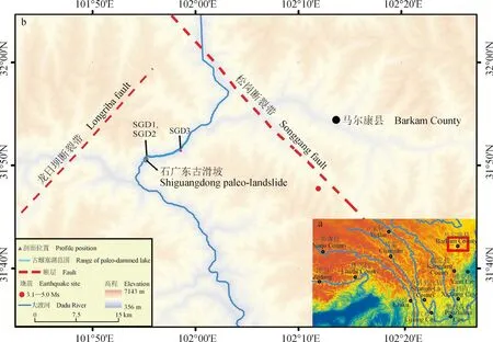
图1 研究区位置示意图(a)和采样点位置图(b)Fig.1 Location of study area (a) and sampling site (b)

图2 典型的石广东湖相沉积剖面Fig.2 Characteristics of lacustrine sediments
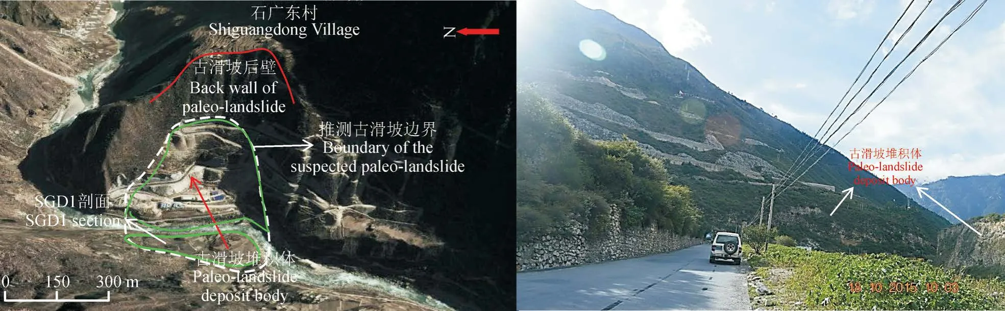
图3 石广东古滑坡坝特征Fig.3 Characteristics of Shiguangdong paleolandlside
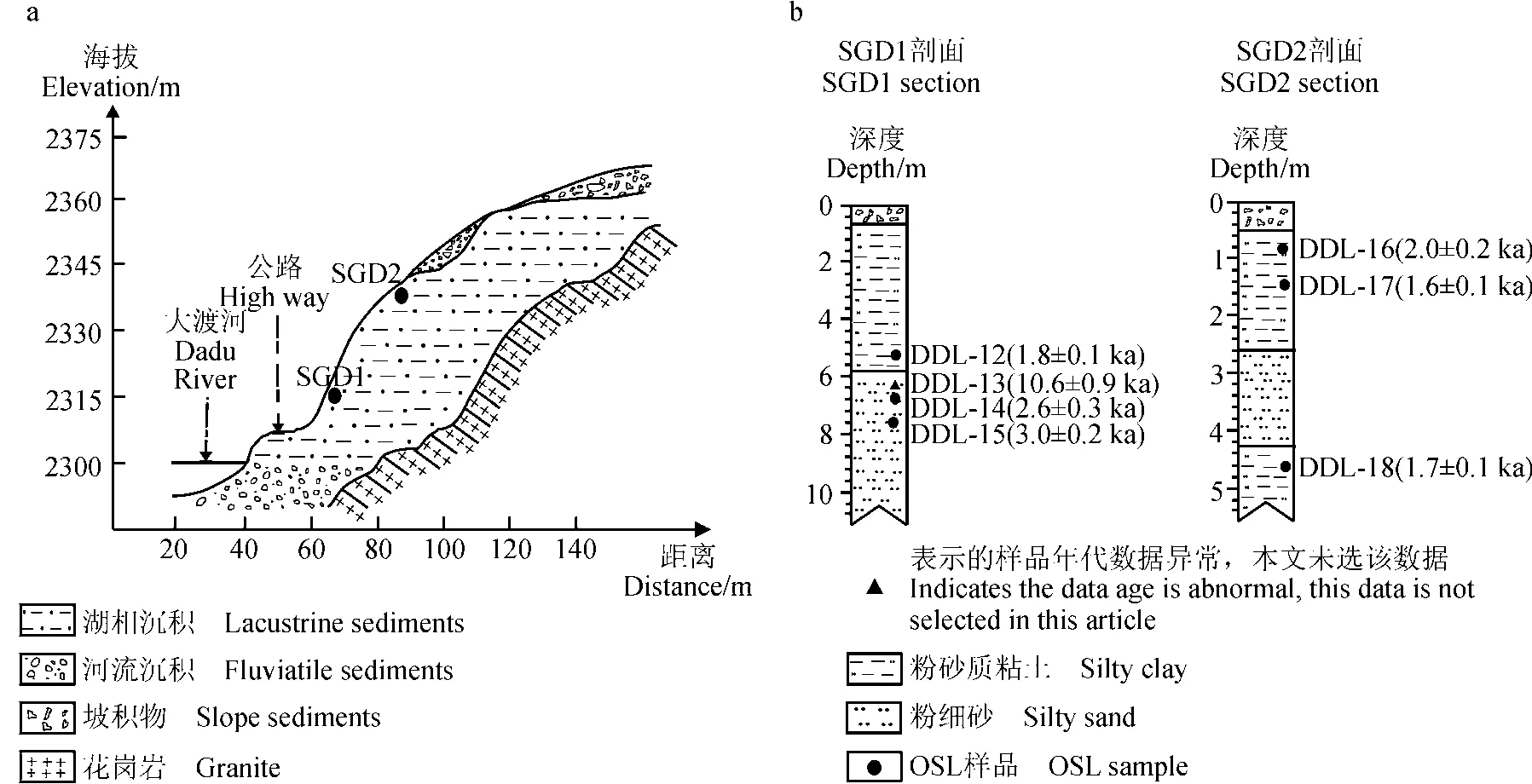
图4 采样剖面地层(a),SGD1和SGD2剖面岩性、采样深度及年代(b)Fig.4 Stratigraphy of sample prof i le (a), lithology and chronology of sections SGD1 and SGD2 (b)
3 OSL测年
3.1 样品前处理及实验操作
实验室进行OSL测年前处理的样品,均在暗室内进行。首先将钢管两端厚约3—4 cm有可能曝光的部分取出,用于含水率的计算,即称完湿重后在烘箱中烘干(40℃,2—3 d,以重量不再发生变化为标准),再称干重,计算含水率。随后将测完含水率的样品选取4 g用玛瑙研钵磨成粉末状(粒径<30 μm),最后选3 g送往中国原子能科学研究院用于中子活化分析法(neutron activation analysis,NAA)测量样品的 U、 Th、 K 含量。
接下来,在暗室内对钢管中部未曝光的样品先用10%的盐酸和30%的双氧水分别去除碳酸盐和有机质,然后湿筛得到38 — 63 μm粒径组分的样品。将筛取的样品用35%的氟硅酸刻蚀2周以去除长石矿物(赖忠平和欧先交,2013),接着滴入少量10%盐酸去除反应产生的氟化物沉淀,然后用清水洗3次,放入烘箱烘干用于制备测片。用硅油将纯石英颗粒单层黏附在直径10 mm的不锈钢钢片中间约7 mm的区域内,用于等效剂量(De)的测试。对于提纯的石英,要进行红外释光(infrared stimulated luminescence,IRSL)检测,若有明显的IRSL信号,则需继续用35%的氟硅酸浸泡,直至长石基本被除尽(长石信号/石英信号< 0.1),避免对De造成低估(Lai and Brückner,2008)。
光释光实验在中国科学院·水利部成都山地灾害与环境研究所的德国lexsyg research全自动TL /OSL测量仪上完成,该仪器是一种全新的释光测量系统(Richter et al,2013)。De的测定采用单片再生法(SAR)与标准生长曲线法(SGC)相结合测定,该方法已经在很多湖相沉积研究中成功应用。红外检测采用波长为850 nm激发光源。样品预热温度为260℃,保持10 s,实验剂量的预热温度为220℃。测试石英释光信号的激发光源选择强度为 50 mW ∙ cm−2、波长为 458 ± 5 nm 的蓝光在125℃温度条件下激发90 s,释光信号经由厚2.5 mm的滤光镜Hoya U340 和厚5 mm的干涉滤光片Delta BP365/50 EX进入9235QB光电倍增管进行记录,辐照源为(90Sr)β源。对于粒径为38 — 63 μm 石英的辐射剂量率为 0.12 Gy ∙ s−1,在剂量率计算时α的校正系数选取0.035 ± 0.003(Lai and Brückner,2008)。
3.2 释光特征
等效剂量测定时选取前0.5 s(前5个通道积分值)减去背景值(最后49个通道积分值)的释光信号值,通过将再生剂量与校正后的OSL信号强度进行线性或指数拟合建立光释光信号的剂量响应曲线即光释光生长曲线,确定样品的De值。从DDL-12的光释光信号衰减曲线来看,光释光信号在前2 s内基本衰减到背景值,说明OSL信号的组成主要以快组分为主(图5a)。图5b显示DDL-12样品8个测片的生长曲线及其拟合的标准生长曲线,显示了较好的拟合结果,表明本次测量样品适合SAR-SGC法来测量De。
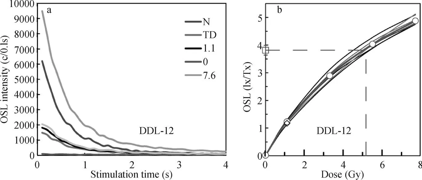
图5 样品DDL-12的衰减曲线(a)和生长曲线(b)Fig.5 Decay curves (a) and growth curves (b) of sample DDL-12
4 结果及讨论
4.1 石广东古堰塞湖的年代
两个剖面的OSL测年结果详见表1,并且在采样岩性柱图4上标注。从测年结果来看,SGD1剖面4个样品的OSL年代结果除了DDL-13的年代结果为10.6 ± 0.9 ka(此样品年代结果不加入最终结果讨论),明显老于下层样品的年龄之外,其余3个样品年代结果在误差范围内从上到下基本随着地层顺序变化,从顶部DDL-12的1.8 ±0.1 ka到底部DDL-15的3.0 ± 0.2 ka,年代符合下老上新的地层沉积规律。造成DDL-13样品年代异常的原因可能是是由于水成沉积物晒退不均一所致。SGD2剖面的3个样品中,DDL-16样品年代略老于下层DDL-17和DDL-18。如果考虑到OSL测年的误差,总体上剖面的年代没有明显差异,并且接近于SGD1剖面顶部的年代1.78 ± 0.14 ka。虽然DDL-15样品并不是采集于剖面底部,但是由于堰塞湖的沉积较快(Liu et al,2015),可以推断研究区古堰塞湖形成年代约为3.0 ka,结束于约1.6 ka。
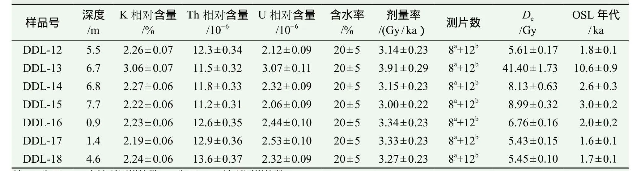
表1 样品剂量率及OSL测年年代结果Tab.1 Dose rate and OSL dating results of the samples
4.2 石广东古堰塞湖形成机制的分析
堵江的巨型滑坡多数由于地震或者降雨引发,占堰塞湖总数的90%(Costa and Schuster,1988)。石广东古堰塞湖的北面为近东西向的龙日坝断裂,此断裂为晚第四纪新生的强活动逆-右旋走滑断裂带,其北东段平均右旋滑动速率为5.4 ±2.0 mm ∙ a−1,垂直滑动速率约 0.7 mm ∙ a−1,地壳缩短率约 0.55 mm ∙ a−1,表现出了很强的发震潜力(徐锡伟等,2008),已经发现了其晚第四纪以来的四次古地震事件,最近的一次发生于距今在5080 ±90 cal a BP,估算的震级约Mw 7.4级(Ren et al,2013)。其东面为抚边河断裂,是一条第四纪隐伏断裂,总体走向N40°—50°W,倾向NE,走滑速率为 0.2 — 1.3 mm ∙ a−1,发震能力的上限为 Mw 7 级(刘维亮等,2007)。可见区域具备诱发石广东古滑坡的地震条件,但是目前仍然缺乏明确的历史地震记载和古地震证据。
在极端暴雨作用下,也容易诱发滑坡的发生。对古气候记录的最新总结表明,8 — 3 ka的中全新世是夏季风降水量/湿度最大的阶段(陈建徽等,2016),其后降雨量开始减少。石广东古堰塞湖形成的3.0 ka,属于气候过渡阶段,而黄土高原的古洪水记录表明,在过渡阶段气候系统极不稳定,往往极端降雨事件较多(Huang et al,2012),这种规律可能同样适用于其他气候区。3.0 ka时,可能极端降雨事件较多,极端降雨事件容易触发滑坡,推测具备石广东滑坡发生的降雨条件。但是,目前距离石广东最近的马尔康县气象站的年均降雨量781 mm,夏季(6 — 9月)累积降雨量515 m,属于干旱河谷区,很难达到诱发滑坡的暴雨条件。并且,从已有的记载来看,地震诱发的滑坡堵江事件要远多于降雨诱发的。1783年意大利卡拉布里亚地震形成215处堰塞湖,1929年新西兰南岛发生的7.6级地震后形成了至少11处堰塞湖(Costa and Schuster,1988)。1999年9·21台湾地震,在清水河的上游形成许多堰塞湖,1933年在岷江上游、1978在大渡河发生的地震均导致了大规模堰塞湖的发生,2008年5·12汶川地震后形成了超过200处堰塞湖,如规模最大的唐家山堰塞湖(刘宁等,2013)。另外,自然界中的堵江滑坡多数为高速远程滑坡,需要很大的启动力,多为地震诱发。因此推断石广东古堰塞湖最有可能是地震触发。
由上述可以推断,石广东古堰塞湖可能由于地震触发。但是,石广东古滑坡的形成机制需要进一步的研究模型试验和古滑坡体的详细特征研究得出。石广东古堰塞湖形成的年代约3.0 ka,属于全新世的年轻地质事件,当时的地质环境条件与现今的非常接近,该区域仍然存在发生类似事件的可能性,需警惕类似石广东古堵江事件的风险。
5 结论
通过野外调查,依据地质证据,推断大渡河上游的石广东古堰塞湖可能由地震触发。并对两处湖相沉积剖面的7个样品进行OSL年代测试,得出该古堰塞湖的形成年代约3.0 ka,结束于约1.6 ka,即全新世晚期。初步推测石广东古滑坡是由于地震触发,目前该区域仍需警惕类似堵江事件的风险。
巴仁基, 王 丽, 郑万模, 等. 2011. 大渡河流域地质灾害特征与分布规律[J].成都理工大学学报(自然科学版), 38(5): 529 – 537. [Ba R J, Wang L, Zheng W M, et al. 2011. Characteristics and distribution of the geology disaster of the Dadu River in Sichuan, China [J].Journal of Chengda University of Technology (Science &Technology Edition), 38(5): 529 – 537.]
柴贺军, 刘汉超. 1995. 中国滑坡堵江事件目录[J].地质灾害与环境保护, 6(4): 1 – 9. [Chai H J, Liu H C. 1995. The catalog of Chinese landslide dam events [J].Journal of Geological Hazards and Environment Preservation, 6(4):1 – 9.]
陈建徽, 饶志国, 刘建宝, 等. 2016. 全新世东亚夏季风最强盛期出现在何时?——兼论中国南方石笋氧同位素的古气候意义[J].中国科学: 地球科学, 46(11):1494 – 1504. [Chen J H, Rao Z G, Liu J B, et al. 2016. On the timing of the East Asian summer monsoon maximum during the Holocene — Does the speleothem oxygen isotope record reflect monsoon rainfall variability? [J].Science China Earth Sciences, 46(11): 1494 – 1504.]
崔 鹏, 韩用顺, 陈晓清. 2009. 汶川地震堰塞湖分布规律与风险评估[J].四川大学学报(工程科学版), 41:35 – 42. [Cui P, Han Y S, Cheng X Q. 2009. Distribution and risk analysis of Dammed lakes reduced by Wenchuan earthquake [J].Journal of Sichuan University (Engineering Science Edtion), 41: 35 – 42.]
黄润秋, 王运生, 董秀军. 2009. 2009年8.6四川汉源猴子岩崩滑的现场应急调查及危岩处理[J].工程地质学报,17(4): 445 – 448. [Huang R Q, Wang Y S, Dong X J. 2009.The 6th August 2009 fi eld urgent investigation on the geohazard of the rock fall damming in Houziyan, Shunhe,Hanyuan, Sichuan [J].Journal of Engineering Geology,17(4): 445 – 448.]
赖忠平, 欧先交. 2013. 光释光测年基本流程[J].地理科学进展, 32(5): 683 – 693. [Lai Z P, Ou X J. 2013. Basic procedures of optically stimulated luminescence (OSL)dating [J].Progress in Geography, 32(5): 683 – 693.]
李海龙, 张岳桥, 乔彦松, 等. 2015. 青藏高原东缘大渡河中游深切河谷沉积物及其地震地质意义[J].地质通报, 34(1): 104 – 112. [Li H L, Zhang Y Q, Qiao Y S, et al.2015. A study of the sediments in the middle reaches of the Dadu River on the eastern margin of the Tibetan Plateau and its seismogeological implications [J].Geological Bulletin of China, 34(1): 104 – 112.]
刘 宁, 程尊兰, 崔 鹏, 等. 2013. 堰塞湖及其风险控制 [M]. 北京 : 科学出版社 : 1 – 388. [Liu N, Cheng Z L,Cui P, et al. 2013. Dammed lake and risk mangement [M].Beijing: Science Press: 1 – 388.]
刘维亮, 杨振法, 谷 曼, 等. 2007. 大渡河金川水电站外围抚边河断层活动性研究[J].沉积与特提斯地质,27(4): 74 – 79. [Liu W L, Yang Z F, Gu M, et al. 2007. The Fubian River fault activity near the Jinchuan hydropower station, Dadu River, Sichuan [J].Sedimentary Geology and Tethyan Geology, 27(4): 74 – 79.]
徐锡伟, 闻学泽, 陈桂华, 等. 2008. 巴颜喀拉地块东部龙日坝断裂带的发现及其大地构造意义[J].中国科学D辑: 地球科学, 51(10): 529 – 542. [Xu X W, Wen X Z,Chen G H, et al. 2008. Discovery of the Longriba fault zone in eastern Bayan Har block, China and its tectonic implication [J].Science in China Series D: Earth Sciences,51(9): 1209 – 1223.]
张培震, 邓起东, 张国民, 等. 2003. 中国大陆的强震活动与活动地块[J].中国科学: D辑, 33(S1): 12 – 20. [Zhang P Z, Deng Q D, Zhang G M, et al. 2003. Strong earthquakes and crustal block motion in continental China [J].Science in China (Series D), 33(S1): 12 – 20.]
Bonnard C. 2011. Technical and human aspects of historic rockslidedammed lakes and landslide dam breaches [M]// Evans S G,Hermanns R L, Strom A, et al. Natural and artif i cial rockslide dams. Berlin/Heidelberg: Springer: 101 – 122.
Costa J E, Schuster R L. 1988. The formation and failure of natural dams [J].Geological Society of America Bulletin,100: 1054 – 1068.
Dai F C, Lee C F, Deng J H, et al . 2005. The 1786 earthquaketriggered landslide dam and subsequent dam-break flood on the Dadu River, southwestern China [J].Geomorphology, 65: 205 – 221.
Hermanns R L, Niedermann S, Ivy-Ochs S, et al. 2004. Rock avalanching into a landslide-dammed lake causing multiple dam failure in Las Conchas valley (NW Argentina) — evidence from surface exposure dating and stratigraphic analyses [J].Landslides, 1(2): 113 – 122.
Huang C C, Pang J L, Zha X C, et al. 2012. Sedimentary records of extraordinary fl oods at the ending of the mid-Holocene climatic optimum along the Upper Weihe River China [J].Holocene, 22: 675 – 686.
Lai Z P, Brückner H. 2008. Effects of feldspar contamination on equivalent dose and the shape of growth curve for OSL of silt-sized quartz extracted from Chinese loess [J].Geochronometria, 30: 49 – 53.
Larsen I J, Montgomery D R, Korup O. 2010. Landslide erosion controlled by hillslope material [J].Nature Geoscience, 3:247 – 251.
Liu W M, Lai Z P, Hu K H, et al. 2015. Age and extent of a giant glacial-dammed lake at Yarlung Tsangpo gorge in the Tibetan Plateau [J].Geomorphology, 246: 370 – 376.
Ouimet W B, Whipple K X, Royden L H, et al. 2007. The inf l uence of large landslides on river incision in a transient landscape: Eastern margin of the Tibetan Plateau (Sichuan,China) [J].Geological Society of America Bulletin, 119:1462 – 1476.
Ren J J, Xu X W, Yeats R S, et al. 2013. Holocene paleoearthquakes of the Maoergai fault, eastern Tibet [J].Tectonophysics, 590: 121 – 135.
Richter D, Richter A, Dornich K. 2013. Lexsyg — A new system for luminescence research [J].Geochronometria,40: 220 – 228.
Age of paleo-landslide-dammed lake at Shiguangdong in Dadu River
XIA Yinzhen1, LIU Weiming2, LAI Zhongping3, HU Kaiheng2, ZHU Zhengfeng4, WANG Hao5, ZHANG Xinbao6,CAO guangchao1
1. School of Life and Geographic Science, Qinghai Normal University, Xining 810008, China
2. CAS Key Laboratory of Mountain Hazards and Surface Process, Institute of Mountain Hazards and Environment, Chinese Academy of Sciences, Chengdu 610041, China
3. School of Earth Sciences, China University of Geosciences, Wuhan 430074, China
4. School of Tourism and Geographical Sciences, Yunnan Normal University, Kunming 650500, China
5. Institute of Tibetan Plateau Research, Chinese Academy of Sciences, Beijing 100101, China
6. Institute of Mountain Hazards and Environment, Chinese Academy of Sciences, Chengdu 610041, China
Date: 2017-04-08; Accepted Date: 2017-07-21
Youth Science Fund of Institute of Mountain Hazards and Environment, Chinese Academy of Sciences (SDSQN-1602); National Key Basic Research Program of China (2015CB452704); National Natural Science Fundation of China (41661144028, 41771023)
LIU Weiming, E-mail: liuwm@imde.ac.cn
Background, aim, and scopeDadu River is as one of the river in eastern fringe of the Tibetan Plateau.As it lies in the intersection of Xianshuihe, Anninghe and Longmenshan fault belt, thus the unique tectonic background and geomorphology have contributed to the formation of many landslide-dammed lakes. At present,the research on landslide dammed lake mainly ref l ects the two major aspects-mechanism of formation and disaster prevention and mitigation, and using the method of chronology is seldom discussed systematically. Damming is one of an important earth surface process, and always leads to disastrous results. The study of paleo-dammed lake contributes to the understanding of the regional risk of blocking river. In this paper, we study Shiguangdong(SGD) landslide dammed lake at the upstream of Dadu River in the eastern margin of the Tibetan Plateau. The sediment evidences show that the dam height is about 23 m, the volumes of landslide and minimum storage capacity are 16 million cubic metres and 20 million cubic metres. In recent years, more and more scholars have paid more attention to the relationship between the lake and the landscape.Materials and methodsTwo prof i les were chosen and collected 7 optically stimulated luminescence (OSL) samples of which 4 samples from SGD1 prof i le and 3 samples from SGD2 prof i le, all the samples were kept from light in a dark place. First, the samples were processed chemically to remove carbonate and organic matter, then 38 — 63 μm quartz components were selected from the sample of purif i cation, for the OSL dating experiment. The method of single aliquot regeneration(SAR) combined with standard growth curve (SGC) was adopted to study the optically stimulated luminescence dating of seven lacustrine samples, which were collected from these two prof i les in Shiguangdong.ResultsThe 7 effective OSL ages (1.8 ka, 10.6 ka, 2.6 ka, 3.0 ka, 2.0 ka, 1.6 ka, 1.7 ka, on the depth of 5.5 m, 6.7 m, 6.8 m, 7.7 m,0.9 m, 1.4 m, 4.6 m) results showed that the Shiguangdong dammed lake was formed at around 3.0 ka and ended at 1.6 ka.DiscussionThe Longriba fault locates in the north of Shiguangdong dammed lake which is the thrust right strike-slip fault zone, fault motion rate of the north eastern is about 5.4 ± 2.0 mm ∙ a−1, vertical sliding rate is about 0.7 mm ∙ a−1, crustal shortening rate is about 0.55 mm ∙ a−1, showed a strong earthquake potential. In addition,landslides can also be triggered by extreme rainfall. The latest summary of ancient climate record shows 8 — 3 ka in the Holocene is one of the largest stage of summer monsoon rainfall/humidity rainfall began to decrease afterwards.Shiguangdong dammed lake formed at 3.0 ka, belongs to the climate transition stage, and the Loess Plateau of the ancient fl ood records show that during the transition stage of the climate system unstable, more extreme rainfall events occur frequently. Although climate conditions are one of the causes of the lake, it is speculated that the Shiguangdong landslide body may be induced by earthquake by analyzing.ConclusionsThe lake in the upper reaches of the Dadu River is conf i rmed by geological evidence through the fi eld investigation. And the two lacustrine sedimentary section 7 samples of OSL test concluded that the formation of the ancient lake was about 3.0 ka, in the late Holocene. Preliminary speculation that the landslide was triggered by an earthquake, it is still necessary to guard against the risk of a similar incident in this area.Recommendations and perspectivesSo except to the study of disaster risk of the dammed lake, it has profound signif i cance to combine the time scale ref l ected by ages data with the research for the dammed lake landscape evolution and formation mechanism. As we inferred that the ancient lake in Shiguangdong may have been triggered by an earthquake. However, the formation mechanism of the ancient landslide need further study for the model and the detailed characteristics for the ancient slide. In the next work can explore the relationship between Shiguangdong lake and other lake in Dadu River, it belongs to the same ancient lake or two ancient lake respectively, and what is the connection between them, these questions need to be further discussed and the research carried out by researchers.
Dadu River; Shiguangdong; paleo-dammed lake; optically stimulated luminescence dating
2017-04-08;录用日期:2017-07-21
中国科学院·水利部成都山地灾害与环境研究所青年科学研究基金项目(SDS-QN-1602);国家重点基础研究发展计划项目(2015CB452704);国家自然科学基金项目(41661144028,41771023)
刘维明,E-mail: liuwm@imde.ac.cn
夏银珍,刘维明,赖忠平, 等. 2017. 大渡河石广东古滑坡堰塞湖沉积物光释光年代研究[J].地球环境学报, 8(5): 419 – 426.
: Xia Y Z, Liu W M, Lai Z P, et al. 2017. Age of paleo-landslide-dammed lake at Shiguangdong in Dadu River [J].Journal of Earth Environment, 8(5): 419 – 426.
猜你喜欢
水利水电快报(2023年1期)2023-01-18 14:27:54
英语文摘(2020年8期)2020-09-21 08:50:52
高原山地气象研究(2020年3期)2020-07-16 07:53:52
水利水电快报(2019年5期)2019-09-10 07:22:44
有色冶金设计与研究(2019年6期)2019-03-25 07:29:38
能源(2018年6期)2018-08-01 03:41:54
西南石油大学学报(自然科学版)(2018年2期)2018-06-26 06:19:08
廉政瞭望(2016年13期)2016-08-11 11:22:02
水利科技与经济(2016年10期)2016-04-26 08:40:20
中国海上油气(2015年3期)2015-07-01 16:31:58
