无人飞艇低空高光谱遥感数据采集和处理初探
任文艺,伍丹,秦林
(1.西北农林科技大学理学院,陕西杨凌712100;2.长江师范学院三峡生态环境监测与灾害防治研究中心,重庆408100)
无人飞艇低空高光谱遥感数据采集和处理初探
任文艺1,2,伍丹1,秦林2
(1.西北农林科技大学理学院,陕西杨凌712100;2.长江师范学院三峡生态环境监测与灾害防治研究中心,重庆408100)
报道了无人飞艇低空高光谱遥感数据采集和处理的初步研究结果,阐述了该遥感系统的构成和数据采集原理,集中讨论了辐射校正、正射矫正、地表反射率计算和归一化植被指数反演等数据处理过程和初步结果,为无人飞艇低空高光谱遥感技术在三峡库区环境监测的应用奠定了基础。
无人飞艇;低空遥感;高光谱遥感;数据处理
高光谱遥感技术是20世纪80年代发展起来的一种可以同时获取目标图像和光谱信息的高新技术[1],具有高光谱分辨率、图谱合一、波段多等优点,在精准农业、生物医学、食品检测、矿藏探测、环境监测、大气探测等领域具有重要的科学意义和广泛的应用价值[2-4]。
以卫星和航天飞机等航天飞行器为平台的遥感探测[5、6]能够获得大尺度空间目标的遥感图像,但是投入成本高、空间分辨率低、观察受天气情况影响严重[7、8]。为了克服这些缺点,人们致力于研究以飞机、气球、飞艇等为平台的低空遥感探测。近年来,以无人飞行器(Unmanned Aerial Vehicle,UAV)为平台的低空遥感探测深受关注且发展迅速。它具有高分辨率、高精度、低成本、低重量、低噪声、低风险、低飞行高度和低速度等突出特点,已广泛运用于科学研究、经济建设、社会发展、以及国防军事等多个领域,如数字城市建设、国土资源调查、石油勘探、地质灾害监测、矿山监测、环境变化监测、工程设计、精准农业、商业广告、电影制作和救灾等[9-23]。
目前低空遥感平台主要是无人固定翼飞机或无人直升机,搭载的成像器件以数码相机和多光谱成像系统为主[17-23]。应用无人飞艇搭载高光谱成像光谱仪进行低空遥感探测,尚在起步阶段。如表1所示,无人飞艇相比无人固定翼飞机和无人直升机具有突出的优势[18]。

表1 不同飞行器作为环境监测研究时的性能比较[19]Table 1 Technical specifications of flight vehicles used in environmental monitoring
无人飞艇低空高光谱遥感系统,由无人飞艇、自动舵系统和地面控制系统构成,如图1所示。自动舵系统由GPS接收器、计算机和陀螺仪组成,任务设备由三轴平台和高光谱成像光谱仪组成。GPS接收器用于定位,陀螺仪用于导航,高光谱成像光谱仪用于成像。

图1 无人飞艇低空高光谱遥感系统示意图Fig.1 The hyperspectral remote sensing system based on low altitude auto-airship
三峡大坝是我国乃至世界最为宏大的水利工程之一,对我国的经济、社会、生态具有重要的影响,为我国生态科学技术的发展提供了独特的机会。清华大学、北京航空航天大学、西安交通大学等多家机构合作,以重庆市长江师范学院为基地,开展三峡生态环境监测和灾害防治研究,目的在于监测和解析各种相互耦合的生态环境过程,支持和推动三峡库区资源的可持续利用。特点是采用无人飞艇高光谱观察,能够对大面积范围内的多种生态环境参数进行高空间和高光谱分辨率的同时测量,进而研究三峡库区的地面环境和水环境的状态和动力学过程。这一获取地面信息的重要技术手段在全面运行后,可以转化为实时的业务系统,为监测三峡生态环境提供独特的数据服务[24]。
1 数据采集
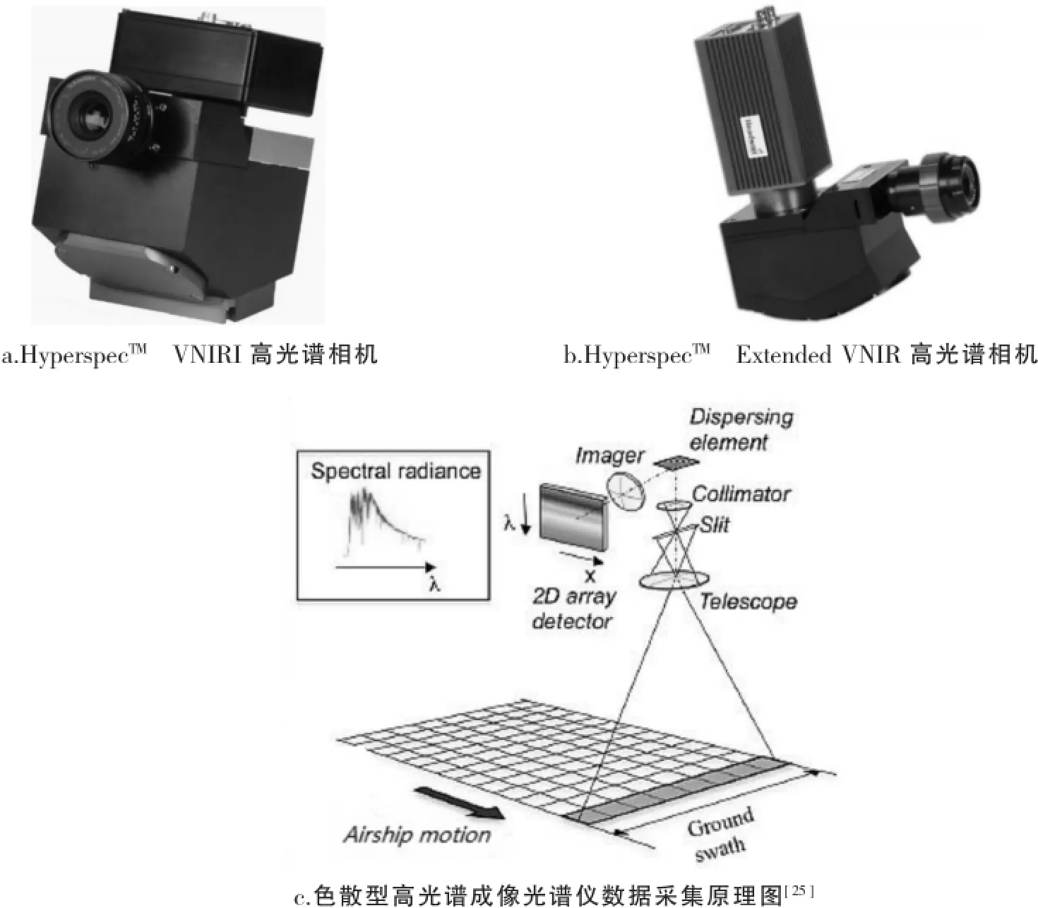
低空遥感高光谱数据是通过HyperspecTMVNIRI高光谱相机(图2a)和HyperspecTMExtended VNIR高光谱相机(图2b)获取。HyperspecTMVNIRI高光谱相机光谱范围为420~1 000 nm,325个波段,探测器为EMCCD,像元数为1 004×1 002,像元尺寸8 μm;HyperspecTMExtended VNIR高光谱相机光谱范围为600~1 600 nm,166个波段,探测器为VIS-InGaAs,像元数为320×256,像元尺寸30 μm。二者均为色散型高光谱成像光谱仪,其工作方式如图2c所示。

图2 数据采集原理图Fig.2 Hyperspectral spectrometers of Hyperspec VNIRI(a)and Hyperspec Extended VNIR(b)and the principle of their data acquisition(c)
将HyperspecTMVNIRI高光谱相机搭载在无人飞艇上,对于涪陵区永胜林场冒合寨管护区的部分松树林区进行了遥感监测,获得了原始高光谱数据。如图3所示,获得一个具有二维空间信息、一维光谱信息的数据立方体,即获取了地面目标(如土壤和松林等)的图像信息和光谱信息。

图3 低空遥感系统采集的原始高光谱数据Fig.3 Raw hyperspectral data(data cubic)collected from the spectrometer on the low altitude auto-airship system
2 辐射校正和正射校正
原始的高光谱图像数据(Digital Numbers,DN)需通过类似下式转化为光谱辐射值[26]。

(1)式中:Lλ为波长λ时的光谱辐射值,为HyperspecTMVNIR相机获取的原始高光谱数据,gain和bias均为地面获取的仪器定标参数。HyperspecTMVNIR相机自带辐射校正和正射校正软件和功能,采取其自带软件(Compact Hyperspectral Data Processing Unit)进行辐射校正以及正射校正。图4a和图4b分别为获取的仅进行辐射校正、同时进行辐射校正和正射校正的处理结果。

图4 校正后的效果图Fig.4 The hyperspectral data subjected to radiation correction alone(a)and to both radiation correction and orthorectification(b)
3 地表反射率
得到光谱辐射数据后,可以通过式(2)计算地表反射率[26]。

(2)式中:Rλ为表观反射率;d为日地距离,单位为天文单位,可以通过观察时间和测量点的经纬度信息计算得到;Esun,λ为标准太阳光谱,单位为mw·sr-1μm-1cm-2;θ为太阳天顶角,可以依据年积日以及经纬度信息计算得到。图5所示为依据式(2)得到的第190波段(波长750.222 nm)的地表反射率,且给出了2个像素所对应的反射率曲线,对应的地面目标分别为土壤和松树。

图5 第190波段地表反射率及反射率曲线Fig.5 The retrieved surface reflectance at the 190th waveband(wavelength 750.222nm)(left)and different reflective spectra of soil(right-top)and pine(right-bottom)
4 归一化植被指数
在获取了反射率数据以后,便可以进行后续和反射率相关的其他参数的反演,如归一化植被指数(NDVI)。在中分辨率成像光谱仪(Moderate Resolution Imaging Spectroradiometer,MODIS)中,NDVI采用波段1(620~670 nm)的红光波段和波段2(841~876 nm)的近红外波段进行反演,反演公式为[26]

(3)式中:R、NIR分别为红光和近红外波段的反射率。
类比MODIS的方案[27],我们将HyperspecTMVNIR中620~670 nm(对应第120到第147波段)的反射率平均值作为红光波段反射率,将841~876 nm(对应第239到第258波段)的反射率平均值作为近红外波段反射率,依据式便可得到NDVI,如图6a所示。依据图6a所得的NDVI值,我们可以对地面目标进行简单的分类,如图6b所示。

图6 NDVI和地面目标分类结果图Fig.6 The retrieved NDVI(a)and classification of vegetation types(b)with pine in green,grass-vert in olive,and soil in yellow
5 结论
本文叙述了在三峡库区生态环境监测中应用无人飞艇低空高光谱遥感监测技术采集和处理数据的初步研究结果。辐射校正和正射校正是基于HyperspecTMVNIR相机自带软件进行处理,地表反射率依据经验公式可以得到。在得到地表反射率的基础上,类比MODIS的NDVI反演得到了地面目标的NDVI图像,并依据NDVI进行了初步的分类,得到了良好的结果。这些研究为后续工作开展图像分类、条带噪声去除、环境监测等方面的研究奠定了基础。
[1]GOETZ A F.Three DecadesofHyperspectralRemote Sensing of the Earth:A Personal View[J].Remote Sensing of Environment,2009,113(9):5-16.
[2]BORENGASSER M,HUNGATE W S,WATKINS R.HyperspectralRemote Sensing:Principlesand Applications[M].BocaRaton,London,New York:CRC Press,2010.
[3]CHANG C.Hyperspectral Data Exploitation:Theory and Applications[M].Hoboken,New Jersey:John Wiley&Sons,2007.
[4]MICHAEL T E.Hyperspectral Remote Sensing[M].Bellingham,Washington:SPIE,2012.
[5]JAMES B C,WYNNE R H.Introduction to Remote Sensing[M].5th ed.New York:Guilford Press,2011.
[6]MARCUS B,WILLIAMS H,RUSSELL W.Hyperspectral Remote Sensing:Principles and Applications[M].1st ed.Boca Raton,London,New York:CRC Press,2007.
[7]WANG W Q.Near-Space Remote Sensing[M].Heidelberg,Dordrecht,London,New York:Springer,2011.
[8]CALERO D P,PEYAUD A,VANDER W D,et al.Low Altitude Remote Sensing[EB/OL].(2008-10-09)[2016-02-11].http: //proceedings.spiedigitallibrary.org/proceeding.aspx?articleid=796170.
[9]JIN W,GE H L,DU H Q,et al.A Review on Unmanned Aerial Vehicle Remote Sensing and its Application[J].Remote Sensing Information,2009,(1):88-92.
[10]白由路,金继运,杨俐苹,等.低空遥感技术及其在精准农业中的应用[J].中国土壤与肥料,2004(1):3-6.
[11]ALBERT R,ANDREA L,JEFFREY E H,et al.Unmanned Aerial Vehicle-based Remote Sensing for Rangeland Assessment,Monitoring,and Management[J].Journal of Applied.Remote Sensing.2009,3(1):1-15.
[12]RJES J B,MARZOLFF I.Identification of Sediment Sources by Large-scale Aerial Photography Taken From a Monitoring Blimp[J]. Remote Sensing Information,1997,22(3-4):295-302.
[13]ALBERTO E,SAMUEL S B,MARCEL B,et al.A Semi-Autonomous Robotic Airship for Environmental Monitoring Missions[J]. Proceedings of the 1998 IEEE International Conference on Robotics&Automation.Belgium:Leuven,1998,4(1):3449-3455.
[14]QIN J.Reliability Analysis of Airship Remote Sensing System,Imaging System Technology for Remote Sensing[EB/OL].(1998-08-18)[2016-02-12].http://proceedings.spiedigitallibrary.org/proceeding.aspx articleid=964941.
[15]BEN D E,SCHLAPFER D,PLAZA A J,et al.Hyperspectral Remote Sensing[J].Airborne Measurements for Environmental Research:Methods and Instruments,2013,36(1):413-456.
[16]宋晓宇,王纪华,刘良云,等.利用航空成像光谱数据进行冬小麦产量预测[J].遥感技术与应用,2004,19(3):168-172.
[17]JENSEN T,APAN A,YOUNG F R,et al.Assessing Grain Crop Attributes Using Digital Imagery Acquired From a Low-altitude Remote Controlled Aircraft[EB/OL].[2016-02-12].http://xueshu.baidu.com/s wd=paperuri:(7f5239c117cc340f6775037f95cb61af)&filter=sc_ long_sign&sc_ks_para=q%3DAssessing+grain+crop+attributes+using+digital+imagery+acquired+from+a+low-altitude+remote+controlled+aircraft&tn=SE_baiduxueshu_c1gjeupa&ie=utf-8&sc_us=5596640295047937414.
[18]RJES J B,MARZOLFF I.Monitoring of Gully Erosion in the Central Ebro Basin by Large-Scale Aerial Photography Taken From a Remotely Controlled Blimp[J].Catena,2003,50(2):309-328.
[19]洪霞,江洪,余树全.高光谱遥感在精准农业生产中的应用[J].安徽农业科学,2010,38(1):529-531.
[20]杨敏华.面向精准农业的高光谱遥感作物信息获取[D].北京:中国农业大学博士学位论文,2002.
[21]ABER J S.Lighter-than-air Platforms for Small-format Aerial Photo-graphy[J].Transactions of the Kansas Academy of Science,2004,107(1):39-44.
[22]HERWITZ S R,JOHNSON L F,DUNAGAN S E,et al.Imaging From an Unmanned Aerial Vehicle:Agricultural Surveillance and Decision Support[J].Computers and Electronics in Agriculture,2004,44(1):49-61.
[23]MACARTHUR D,SCHUELLER J K,CRANE C D.Remotely-piloted Mini-helicopter Imaging of Citrus[EB/OL].(2005-01-01)[2016-02-12].https://www.researchgate.net/publication/271438646_Remotely-Piloted_Mini-Helicopter_Imaging_of_Citrus.
[24]王鼎益,张淳民,秦林,等.无人飞艇高光谱遥感监测三峡库区生态环境[EB/OL].(2015-06-04)[2016-02-12].http://sxyg.yznu. cn/Item/Show.asp m=117&d=3.
[25]BERND S,JEAN-LOUP B,JEROME C,et al.The GMES Sentinel-5 Mission for Operational Atmospheric Monitoring:Status and Developments,Proceedings of the ICSO(International Conference on Space Optics)[EB/OL].[2016-02-12].http://xueshu.baidu. com/swd=paperuri:(650fc31a568cb6e99bf64547372c04b7)&filter=sc_long_sign&sc_ks_para=q%3DThe+Copernicus+Sentinel-5+mission+for+operational+atmospheric+monitoring%3A+status+and+developments&tn=SE_baiduxueshu_c1gjeupa&ie=utf-8&sc_us= 9932272204746252062.
[26]CHEN xuexia,VIERLING L,DEERING D.A Simple and Effective Radiometric Correction Method to Improve Landscape Change Detection across Sensorsand across Time[J].Remote Sensing of Environment,2005,98(1):63-79.
[27]MAO K,SHI J,QIN Z,et al.Land Surface Temperature and Emissivity Retrieval from Remote Sensing Data[EB/OL].[2016-02-11]. http://xueshu.baidu.com/s?wd=paperuri:(1b683f25293da5b82ec3c19477bc420e)&filter=sc_long_sign&sc_ks_para=q%3DLand+surface+temperature+and+emissivity+retrieved+from+AMSR+passive+micro-wave+data&tn=SE_baiduxueshu_c1gjeupa&ie=utf-8&sc_us=18001473264592384750.
[责任编辑:肖红艳]
Preliminary Study on Data Collecting and Processing of Unmanned Airship Low Altitude Hyperspectral Remote Sensing
REN Wen-yi1,2,WU Dan2,QIN Lin2
(1.School of Science,Northwest A&F University,Yangling,712100,China;2.Research Center for Eco-Environmental Monitoring, Hazard Prevention and Mitigation of Three Gorges Reservoir,Yangtze Normal University,Chongqing,408100,China)
The initial results of data collecting and processing for low altitude hyperspectral remote sensing based on unmanned airship was presented in this paper.The construction of the system and the principle of its data acquisition and analysis are described,particularly focusing on the radiation correction,orthorectification,retrival of surface reflectance and NDVI(Normolized Differential Vegetation Index).The results set up a significant and fundamental basis for the remote sensing technology implemented to monitor the environmental issues in the region of Three Gorges Dam.
unmanned airship;low altitude remote sensing;hyperspectral remote sensing;data processing
S127
A
2096-2347(2016)02-0052-06
10.19478/j.cnki.2096-2347.2016.02.08
2016-04-09
国家自然科学基金青年基金项目(11504297);国家自然科学基金面上项目(61673314);陕西省科技统筹创新计划—重点产业创新链—工业领域(2016KTZDGY05-02)西北农林科技大学第二批基本科研业务经费项目(2452015225);西北农林科技大学博士科研启动基金项目(Z109021504);重庆市科委社会民生专项项目(cstc2015shmszx20010);重庆市教委科学技术研究项目(KJ131315、KJ1401205);涪陵区科委科研项目(FLKJ2015ABB1097);长江师范学院科研项目(2014XJTD02)。
任文艺(1984—),男,陕西淳化人,博士,讲师,主要从事光谱偏振成像、高光谱遥感图像数据处理及应用研究。E-mail:renovel@nwsuaf.edu.cn

