华北东部复杂的660 km相变界面
刘震, 田小波, 聂仕潭, 段耀晖, 滕吉文
1 中国科学院地质与地球物理研究所, 北京 100029 2 中国科学院大学, 北京 100049
华北东部复杂的660 km相变界面
刘震1,2, 田小波1, 聂仕潭1,2, 段耀晖1,2, 滕吉文1
1 中国科学院地质与地球物理研究所, 北京1000292 中国科学院大学, 北京100049
摘要利用华北固定台网的宽频带地震远震记录波形资料,提取P波接收函数,通过偏移成像和共转换点叠加,得到华北地区东部地幔过渡带深度及厚度的图像.研究结果显示,地幔过渡带上界面(410 km间断面)深度起伏变化不大;在华北地区东部,存在较厚的地幔过渡带,地幔过渡带下界面(660 km间断面)在660 km深度附近出现两个不同的界面.造成地幔过渡带增厚并出现两个深度不同的界面的原因可能是存在橄榄岩以外的地幔物质相变,该物质相变拥有与橄榄岩向钙钛矿转变不同的克拉伯龙斜率,太平洋俯冲板块的低温造成两种不同的相变界面发生不同程度的改变.双重660 km间断面的范围存在向北西方向延伸的趋势并且向南至少延伸到30°N.本文的结果可为古西太平洋板块向华北俯冲前缘位置的研究提供约束.
关键词地幔过渡带; 双层660 km间断面; 华北; 接收函数
1引言
华北地区位于菲律宾板块和太平洋板块向欧亚板块俯冲的俯冲带附近,板块的俯冲作用一直被认为是导致华北克拉通破坏的重要因素(Wu et al.,2005;朱日祥等,2011,2012).臧绍先和宁杰远(1996)认为菲律宾板块向欧亚板块俯冲的最大深度不超过250 km;Huang等(2013)利用3-D层析成像的结果显示:菲律宾板块在128°E附近已经俯冲到地幔过渡带深度,但还没有到达地幔过渡带底界发生滞留,所以华北地区地幔过渡带堆积的应该是太平洋板片.Huang和Zhao(2006)对中国及周边地区的地幔层析成像结果显示滞留的太平洋俯冲板片前缘已经到达太行山重力梯度带,Li和Van Der Hilst(2010)利用更多的走时数据得到的结果显示俯冲板片前缘在119°E附近.横波分裂的研究结果(Zhao and Zheng,2005;Zhao et al.,2007;常利军等,2009)显示华北地区上地幔的各向异性与太平洋板块的俯冲(Koppers et al.,2001,2003;Tian and Santosh,2015)密切相关.太平洋板块的俯冲造成华北地区东部岩石圈主要以拉张伸展为主(Xu et al., 2004;宋明春和李洪奎,2001),该地区岩石圈厚度从西向东的明显减薄(郭震等,2012;Chen,2010),地表为一系列新生代盆地(如渤海湾盆地和苏北-南黄海盆地等),其形成过程伴随着地幔局部熔融、侵入和上涌 (邱瑞照等,2004;牛树银等,2004),这些特征都或多或少反应了太平洋板块的俯冲对华北地区的影响.研究太平洋板块的俯冲范围和形态可以对解释华北地区的地质现象提供深部的地球物理证据.
Anderson(1989)将大约在410 km和660 km深处的地震波速度间断面(之后简称为410 km间断面和660 km间断面)之间的区域定义为地幔过渡带,作为上下地幔的分界,两个间断面存在速度突变(P波3.6%和5.6%,S波4%和6%(Kennett and Engdahl, 1991)).这样的速度间断面被认为是地球内部温压条件变化引起的相变界面:410 km间断面是斜方晶系橄榄石(α相橄榄岩)与等轴晶系尖晶石(β相橄榄岩)的相变界面;660 km间断面是γ相尖晶石分解成钙钛矿及镁质方铁矿(方镁石、方铁矿和超石英)的间断面,两种相变具有不同的克拉伯龙斜率(许卫卫等,2011;Birch,1952;Ito and Takahashi,1989;Katsura and Ito,1989;Ringwood,1975).当地幔过渡带物质遇冷,410 km间断面变浅,660 km间断面变深,地幔过渡带变厚;反之,当地幔过渡带物质遇热,410 km间断面变深,660 km间断面变浅,地幔过渡带变薄.板块的俯冲会降低地幔过渡带的温度,造成其增厚,一般温度下降6~7 ℃可以造成地幔过渡带增厚1 km(Bina and Helffrich,1994; Stixrude, 1997; Helffrich, 2000).Ai和Zheng(2003)的研究结果认为,西太平洋的俯冲板片没有对华东地区的410 km间断面产生重大的影响,而对660 km间断面的影响比较复杂,在119°E以东出现双层的660 km间断面.Gao等(2010)利用中国东部固定地震台站数据的研究结果表明,从中国东北到华南有部分台站下方660 km附近存在两个明显的界面.Chen和Ai(2009)和Chen(2010)的结果显示华北克拉通南部发现双层的660 km界面,地幔过渡带厚度达到290 km以上.虽然前人的很多结果发现了双层660 km界面的存在,但是双层的660 km界面到底延伸到什么位置,还需要更大范围、更多数据的研究.
接收函数通过对远震波形记录的反褶积运算,在径向分量中消除震源时间函数、大圆弧路径传播路径响应以及台站的仪器响应,使得接收函数仅包含反映台站下方速度结构的转换波及其多次波(刘启元等,1997;吴庆举和曾融生,1998;胡家富等,2003),可以有效追踪到410 km间断面和660 km间断面的P-S转换波震相.本研究对华北地区的宽频带地震数据通过接收函数方法分析得到华北地区410 km和660 km间断面的深度,对双660 km界面的分布也提供了新的证据,对古太平洋板片俯冲前缘位置有一定的约束作用.
2数据方法
本文使用山东(2007年8月—2009年10月,2011年1月—2013年11月)、安徽(2007年8月—2009年10月,2011年1月—2013年11月)、江苏(2011年1月—2013年11月)三省固定台网三分量宽频带地震仪接收到的远震波形数据,共81个宽频带地震台站,挑选震中距在30°~90°之间震级大于5的地震事件计算径向接收函数.台站及事件的分布情况如图1所示,图1a表示台站在研究区域内的分布情况,三角形表示台站分布的位置,台站主要分布在华北克拉通东部,郯庐断裂带两侧,台站平均间距约100 km;如图1b所示研究区域位于欧亚板块东部,菲律宾板块和太平洋板块向欧亚板块俯冲的前缘;图1c粉色点标出了事件的分布,地震主要分布在环太平洋地震带以及欧亚地震带,地震反方位角主要覆盖研究区域的南方,东北以及西北.

图1 台站,事件和研究区域的相对位置(a) 三角形表示台站的位置; (b) 研究区域相对周围板块的位置; (c) 紫色点表示事件的位置.Fig.1 Thedistribution of the stations and events(a) The open triangles are the permanent stations in the east of north China; (b) The location of our study region and the plates surrounding; (c) The violet dots are the distribution of the events.
首先,对三分量地震波形数据进行0.03~2.0 Hz的带通滤波,去除高频和低频噪声信号的干扰,截取选取P波初动到前20 s,初动后100 s的震相,通过对原始三分量旋转得到垂向,径向和切向的地震记录.并对径向和垂向分量在频率域做反褶积(司少坤等,2014),接收函数频率域表达式为:


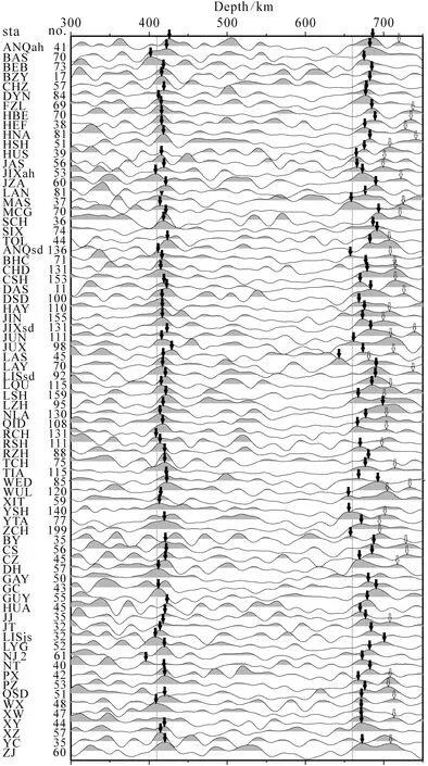
图2 部分台站叠加后的接收函数以及叠加条数,黑箭头标出了410 km间断面和660 km间断面的深度,空心箭头表示在660 km间断面下方大约30 km附近发现的另一个间断面Fig.2 Receiver functions at stations after depth-migrating and stacking. Station names and the numbers of receiver function used in stacked are listed in the left. The discontinuity at the depth of 410 km and 660 km were marked by black arrows, another discontinuity which is about 30 km below the 660 km discontinuity was marked by hollow arrows
对同一个台站挑选出来的接收函数通过IASP91模型从时间域转换到深度域后进行叠加.81个台站中有74个叠加效果较好(如图2所示),台站名称后标出了接收函数的叠加条数,其中最少11条,最多199条,平均72.28条.因为410 km和660 km相变界面两侧的地震波波阻抗都是界面上方小于界面下方,这样的界面在接收函数上表现为正振幅.从叠加后的结果可以看出:410 km间断面转换波主要出现在400~430 km之间(峰值位置如图2中黑色箭头所示),平均深度417 km,标准差8.6 km,深于410 km表明华北上地幔地震波速度略低于IASP91模型,可能与古太平洋俯冲形成的地幔楔有关;660 km间断面转换波出现在650~700 km(峰值位置如图2中黑色箭头所示),其中一部分台站在700~750之间出现另外一个转换震相(峰值位置如图2中空心箭头所示).
单个台站的叠加结果反映了台站下方及其附近的地幔过渡带410 km间断面和660 km间断面的深度,由于同一个台站410 km、660 km转换点的空间分布可达300~400 km,因此台站叠加降低了空间分辨能力.为了进一步研究地幔过渡带的形态,我们在研究区内域沿着转换点比较密集的区域划出四条剖面AA′、BB′、CC′、DD′(如图3所示).图3a和图3b分别给出了所有的接收函数在410 km和660 km深度转换点的位置分布,我们对AA′、BB′、CC′、DD′ 四个剖面通过IASP91模型进行偏移成像(吴庆举和曾融生,1998;司少坤,2012;Tian et al., 2011;Tian et al., 2010;Schimmel and Paulssen,1997),将距离测线1°以内的转换点向测线投影,测线方向叠加长度为10 km,垂直方向叠加长度为2 km,得到了地幔410 km间断面和660 km间断面沿着四条剖面的变化图3c—图3f.
如图3c—3f所示,颜色表示界面上下波阻抗的变化,其中红色为正振幅,表示界面下方地震波波阻抗比界面上方大;蓝色为负振幅,表示界面下方地震波波阻抗比界面上方小,颜色越深表示振幅越大,界面越明显.在300~800 km深度出现两条明显的正振幅带,分别代表四条剖面410 km间断面和660 km间断面.四条剖面的结果显示在研究区域内410 km间断面深度均在415±5 km附近,仅有10 km的小范围起伏.而近北西西向的剖面AA′和东西向的剖面DD′显示,660 km间断面在120°E以东出现两个明显的界面;北北东向的剖面BB′和南北向剖面CC′分别在33°以北同样出现两个660 km间断面.虽然在100~250 km深度的界面的多次反射波可能对660 km间断面的成像结果造成干扰(Saul et al., 2000),但我们的结果在这个深度范围没有探测到明显的界面,所以基本排除这一因素的影响.在研究区域的西南,结果中只显示有单层的660 km间断面,平均深度677±6 km,在出现双层660 km间断面的区域,上界面深度为667±4 km,下界面深度为702±9 km.Ai和Zheng(2003),Chen和Ai(2009)和Gao等(2010)在相邻的区域同样发现双重的660 km间断面,认为是非橄榄岩相的相变形成的,支持双660 km间断面的存在.
3结果与讨论
Chen(2010)利用流动宽频带台阵数据和首都圈地震台网数据,通过接收函数方法研究了华北东部地幔过渡带厚度,发现地幔过渡带由西向东在重力梯度带附近迅速增厚,结合地壳、上地幔以及地幔过渡带的结构变化,认为地壳速度结构、岩石圈厚度和地幔过渡带厚度都在华北的东部和中部的分界处(太行山东缘)发生一致的变化,界限基本与重力梯度带一致.这种显著的分区特征可能与西太平洋俯冲及可能由其触发的克拉通破坏有关(Chen, 2010).朱日祥等(2012)认为华北克拉通的破坏得益于古太平洋俯冲板片的脱水,大量的水上升至华北岩石圈底部使其强烈的水化和弱化,导致华北克拉通东部地幔对流系统局部失稳,上覆岩石圈黏滞系数大幅降低,继而发生拆沉或侵蚀,最终华北克拉通遭受破坏.

图3 接收函数共转换点成像(a) 410 km转换点的位置; (b) 660 km转换点的位置; (c)—(f) 分别是剖面AA′、CC′、BB′、DD′的成像结果,颜色表示界面上下波阻抗的变化,其中红色表示界面下方地震波波阻抗比界面上方大,蓝色相反.Fig.3 The common conversion point stacking result of receiver function(a) Distributions of 410 km piercing points; (b) Distributions of 660 km piercing points; (c)—(f) Show the images of profiles AA′、CC′、BB′、DD′, the color indicate the value of wave impedance, red means the wave impedance below the distribution is higher than that above, and blue is opposite.
然而,对西太平洋俯冲前缘位置的研究仍存在不同的研究结果.Huang和Zhao(2006)利用P,pP,PP和PcP等体波震相地幔层析成像的方法(水平分辨率为2°×2°)对中国及周边地区进行研究,结果显示:在华东地区深度400~700 km之间发现一个明显的高速异常,并认为是滞留在地幔过渡带里的太平洋板块引起的,其前缘达到郯庐断裂带附近,高速异常范围在700 km深度有减小的趋势.Li和Van Der Hilst(2010)利用更密集的数据增加使用Pn,Pg,PKP等震相采用有限频体波层析成像方法(水平分辨率3°×3°),在相近的区域600 km深度发现高速异常,高速异常范围在700 km深度有所增大.地幔过渡带中的高速异常前缘同样显示到达郯庐断裂附近,但是地幔过渡带中的高速异常出现不连续性,可能是不同时期的俯冲引起的.
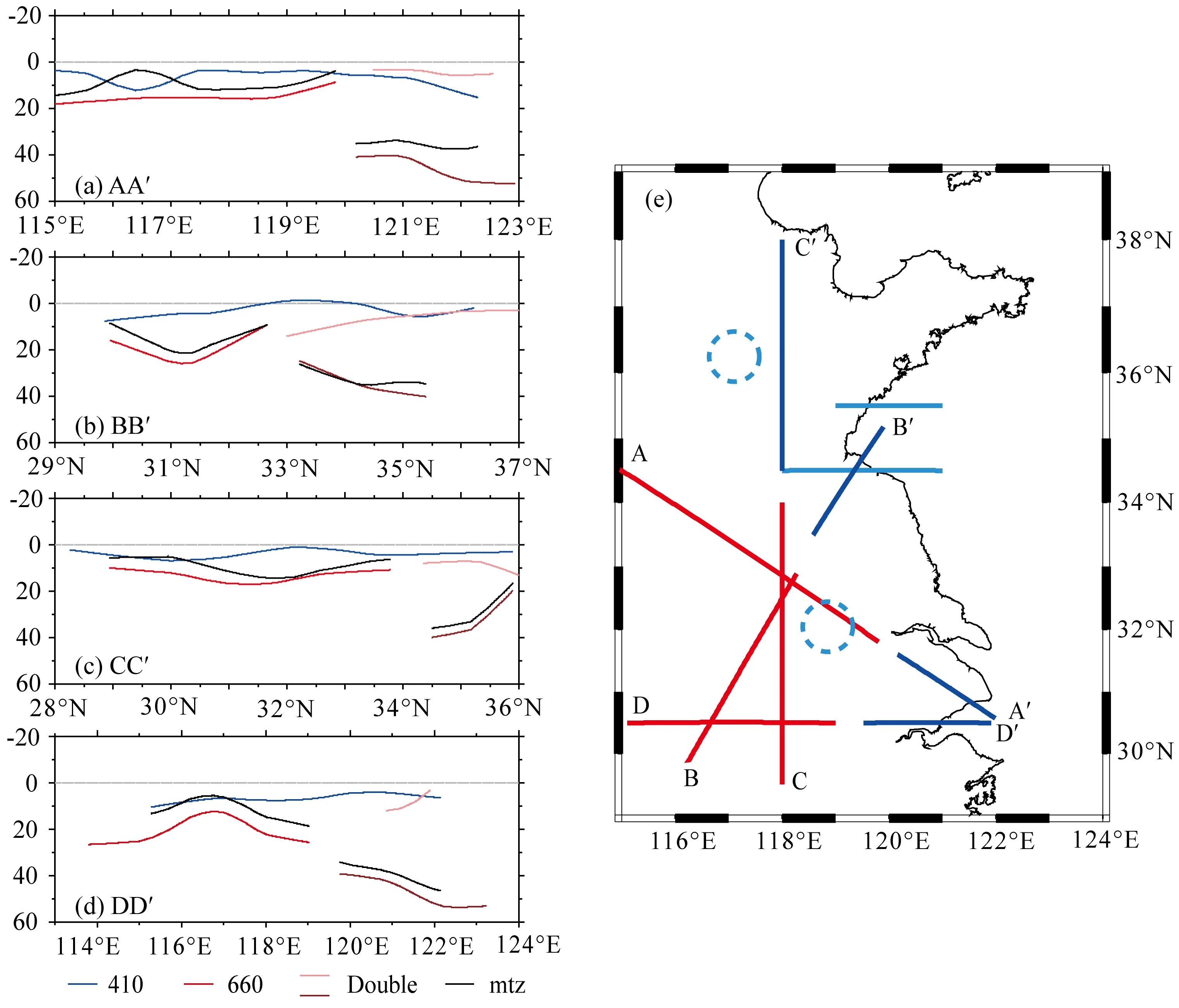
而本文的结果如图4所示:图4a—4d分别为四条剖面410 km间断面,660 km间断面和地幔过渡带厚度与理论值(410 km、660 km、250 km)之间的差异,地幔过渡带厚度为410 km间断面和660 km间断面之间的厚度,在出现双660 km间断面的区域,地幔过渡带厚度为下层660 km间断面与410 km间断面之间的区域厚度.410 km间断面实际深度在理论深度以下10 km的范围内起伏不大.660 km间断面深度在120°E以西以及33°N以南表现为单层,实际深度在670 km以下12 km范围内,地幔过渡带增厚不超过25 km;出现双层660 km间断面的区域,两个间断面分别位于660 km以下10 km范围内和690 km以下20 km范围内,地幔过渡带厚度明显增厚到30~50 km.地幔过渡带厚度分布如图4e所示:在120°E以东以及34°N以北地幔过渡带存在明显的增厚(图4e蓝线),增厚异常在30~50 km,研究区域的西南部,地幔过渡带增厚小于25 km(图4e红线);地幔过渡带增厚基本出现在双层的660 km间断面的地区.

图4 四条剖面的地幔过渡带厚度(a)—(d)分别表示四条剖面410 km界面、660 km界面和地幔过渡带厚度与理论值之差; (e) 红线表示地幔过渡带增厚异常较小(<25 km),蓝线表示地幔过渡带增厚较大(30~50 km)浅蓝色线(Ai and Zheng, 2003; Chen and Ai, 2009)和虚线区域(Gao et al., 2010)表示前人研究结果中发现双660间断面的区域.Fig.4 The thickness of the mantle transition zone of the four profiles(a)—(d) Show the abnormal of the depth of 410 km and 660 km distributions and the thickness of the mantle transition zone; (e) Red lines show the regions where the thickness of the mantle transition zone is thicker less than 25 km, blue lines show the regions where the thickness of the mantle transition zone is thicker between 30~50 km. the light blue lines show the result obtained by Ai and Zheng (2003) and Chen and Ai (2009), where they found the double 660 km distributions, the dash line is the result of Gao et al., (2010)
造成这种现象的原因可能是俯冲的大洋板片将低温(Fukao et al., 2001)和本来不存在于地幔过渡带的物质(比如石榴石)带到660 km间断面附近,使得在660 km附近出现两种不同的相变(Vacher et al., 1998),橄榄岩和钙钛矿被认为是地幔的主要成分,含橄榄岩相变具有负的克拉伯龙斜率,低温会使相变界面变深(Ringwood, 1975; Ito and Takahashi, 1989);不含橄榄岩相变(比如石榴石到钙钛矿的相变(Fukao et al., 2001))可能具有与410 km间断面相变相近的克拉伯龙斜率,所以我们的研究结果在发现地幔过渡带增厚的地区发现了一个几乎与410 km间断面平行的界面.双层的660 km界面分布在中国东部,并且向北向西延伸,这一分布与Ai 和Zheng(2003)、Chen和Ai(2009)(图4e浅蓝色线)的研究结果相符合;图4e浅蓝色虚线标出Gao 等(2010)发现双层660 km界面台站的位置,其用到的地震事件大多来自东南方向,穿透点位置与我们的结果位置相当.双层660 km间断面的分布前缘位于郯庐断裂带附近,这一分布与层析成像的结果大体吻合,所以,双层660 km间断面的位置可以作为是界定太平洋板块俯冲前缘位置的重要约束.
致谢感谢审稿专家和编辑部对本文的支持和帮助.
ReferencesAi Y S, Zheng T Y. 2003. The upper mantle discontinuity structure beneath eastern China.GeophysicalResearchLetters, 30(21): 2089.Anderson D L. 1989. Theory of the Earth. Boston: Blackwell Scientific Publication, 366.Bina C R, Helffrich G. 1994. Phase transitionClapeyronslopesand transition zone seismic discontinuity topography.JournalofGeophysicalResearch, 99(B8): 15853-15860.
Birch F. 1952. Elasticity and constitution of the Earth′s interior.JournalofGeophysicalResearch, 57(2): 227-286.
Chang L J, Wang C Y, Ding Z F. 2009. Seismic anisotropy of upper mantle in eastern China.ScienceinChinaSeriesD:EarthSciences, 52(6): 774-783.
Chen L, Ai Y S. 2009. Discontinuity structure of the mantle transition zone beneath the North China Craton from receiver function migration.JournalofGeophysicalResearch, 114(B6): B06307.
Chen L. 2010. Concordant structural variations from the surface to the base of the upper mantle in the North China Craton and its tectonic implications.Lithos, 120(1-2): 96-115.
Fukao Y, Widiyantoro S, Obayashi M. 2001. Stagnant slabs in the upper and lower mantle transition region.ReviewsofGeophysics, 39(3): 291-323.Gao Y, Suetsugu D, Fukao Y, et al. 2010. Seismic discontinuities in the mantle transition zone and at the top of the lower mantle beneath eastern China and Korea: Influence of the stagnant Pacific slab.PhysicsoftheEarthandPlanetaryInteriors, 183(1-2): 288-295.
Guo Z, Tang Y C, Chen J, et al. 2012. A study on crustal and upper mantle structures in east part of North China Craton using receiver functions.ChineseJournalofGeophysics(in Chinese), 55(11): 3591-3600, doi: 10.6038/j.issn.0001-5733.2012.11.008.
Helffrich G. 2000. Topography of the transition zone seismic discontinuities.ReviewsofGeophysics, 38(1): 141-158.
Hu J F, Su Y J, Zhu X G, et al. 2005. S-wave velocity and poisson′s ratio structure of the crust in Yunnan and its implication.ScienceinChinaSeriesD:EarthSciences, 48(2): 210-218.
Huang J L, Zhao D P. 2006. High-resolution mantle tomography of China and surrounding regions.JournalofGeophysicalResearch, 111(B9): B09305. Huang Z C, Zhao D P, Hasegawa A, et al. 2013. Aseismic deep subduction of the Philippine Sea plate and slab window.JournalofAsianEarthSciences, 75: 82-94.
Ito E, Takahashi E. 1989. Postspinel transformations in the system Mg2SiO4-Fe2SiO4and some geophysical implications.JournalofGeophysicalResearch, 94(B8): 10637-10646.
Katsura T, Ito E. 1989. The system Mg2SiO4-Fe2SiO4at high pressures and temperatures: Precise determination of stabilities of olivine, modified spinel, and spinel.JournalofGeophysicalResearch, 94(B11): 15663-15670. Kennett B L N, Engdahl E R. 1991. Traveltimes for global earthquake location and phase identification.GeophysicalJournalInternational, 105(2): 429-465. Koppers A A P, Morgan J P, Morgan J W, et al. 2001. Testing the fixed hotspot hypothesis using40Ar/39Ar age progressions along seamount trails.EarthandPlanetaryScienceLetters, 185(3-4): 237-252.
Koppers A A P, Staudigel H, Duncan R A. 2003. High-resolution40Ar/39Ar dating of the oldest oceanic basement basalts in the western Pacific Basin.Geochemistry,Geophysics,Geosystems, 4(11): 8914.
Li C, Van Der Hilst R D. 2010. Structure of the upper mantle and transition zone beneath Southeast Asia from traveltime tomography.JournalofGeophysicalResearch, 115(B7): B07308.Liu Q Y, Li S C, Shen C, et al. 1997. Broadband seismic array study of the crust and upper mantle velocity structure beneath Yanhuai basin and its neighbouring region.ActaGeophysicaSinica(in Chinese), 40(6): 763-772.
Niu S Y, Hu H B, Mao W J, et al. 2004. Structure in western Shandong and its genetic mechanism.GeologyinChina(in Chinese), 31(1): 34-39.
Qiu R Z, Deng J F, Zhou S, et al. 2005. Lithosphere types in North China: Evidence from geology and geophysics.ScienceinChinaSeriesD:EarthSciences, 48(11): 1809-1827.
Ringwood A E. 1975. Composition and Petrology of the Earth′s Mantle. New York: McGraw-Hill, 618.
Saul J, Kumar M R, Sarkar D. 2000. Lithospheric and upper mantle structure of the Indian Shield, from teleseismic receiver functions.GeophysicalResearchLetters, 27(16): 2357-2360.
Schimmel M, Paulssen H. 1997. Noise reduction and detection of weak, coherent signals through phase-weighted stacks.GeophysicalJournalInternational, 130(2): 497-505.Si S K, Tian X B, Zhang H S, et al. 2013. Prevalent thickening and local thinning of the mantle transition zone beneath the Baikal rift zone and its dynamic implications.ScienceChina:EarthSciences, 56(1): 31-42.
Si S K, Tian X B, Zhang H S, et al. 2014. Multiple sinusoidal tapers method to estimate receiver function.ChineseJournalofGeophysics(in Chinese), 57(3): 789-799, doi: 10.6038/cjg20140309. Song M C, Li H K. 2001. Study on regional geological structural evolution in Shandong Province.GeologyofShandong(in Chinese), 17(6): 12-21, 38.
Stixrude L. 1997. Structure and sharpness of phase transitions and mantle discontinuities.JournalofGeophysicalResearch, 102(B7): 14835-14852.
Tian X B, Zhao D P, Zhang H S, et al. 2010. Mantle transition zone topography and structure beneath the central Tien Shan orogenic belt.JournalofGeophysicalResearch:SolidEarth, 115(B10): B10308.
Tian X B, Teng J W, Zhang H S, et al. 2011. Structure of crust and upper mantle beneath the Ordos Block and the Yinshan Mountains revealed by receiver function analysis.PhysicsoftheEarthandPlanetaryInteriors, 184(3-4): 186-193.
Tian X B, Santosh M. 2015. Fossilized lithospheric deformation revealed by teleseismic shear wave splitting in eastern China.GSAToday, 25(2): 4-10.
Vacher P, Mocquet A, Sotin C. 1998. Computation of seismic profiles from mineral physics: The importance of the non-olivine components for explaining the 660 km depth discontinuity.PhysicsoftheEarthandPlanetaryInteriors, 106(3-4): 275-298.Wu F Y, Yang J H, Wilde S A, et al. 2005. Geochronology, petrogenesis and tectonic implications of Jurassic granites in the Liaodong Peninsula, NE China.ChemicalGeology, 221(1-2): 127-156.
Wu Q J, Zeng R S. 1998. The crustal structure of Qinghai-Xizang Plateau inferred from broadband teleseismic waveform.ActaGeophysicaSinica(in Chinese), 41(5): 669-679.
Xu W W, Zheng T Y, Zhao L. 2011. Mantle dynamics of the reactivating North China Craton: Constraints from the topographies of the 410 km and 660 km discontinuities.ScienceChina:EarthSciences, 54(6): 881-887.Xu Y G, Chuang S L, Ma J L, et al. 2004. Contrasting Cenozoic lithospheric evolution and architecture in the western and eastern Sino-Korean craton: Constraints from geochemistry of basalts and mantle xenoliths.TheJournalofGeology, 112(5): 593-605. Zang S X, Ning J Y. 1996. Study on the subduction zone in western pacific and its implication for the geodynamics.ActaGeophysicaSinica(in Chinese), 39(2): 188-202.
Zhao D P, Ohtani E. 2009. Deep slab subduction and dehydration and their geodynamic consequences: Evidence from seismology and mineral physics.GondwanaResearch, 16(3-4): 401-413. Zhao L, Zheng T Y, 2005. Using shear wave splitting measurements to investigate the upper mantle anisotropy beneath the North China Craton: distinct variation from east to west.GeophysicalResearchLetters, 32(10): L10309. Zhao L, Zheng T Y, Chen L, et al. 2007. Shear wave splitting in eastern and central China: implications for upper mantle deformation beneath continental margin.PhysicsoftheEarthandPlanetaryInteriors, 162(1-2): 73-84.
Zhu R X, Chen L, Wu F Y, et al. 2011. Timing, scale and mechanism of the destruction of the North China Craton.ScienceChina:EarthSciences, 54(6): 789-797.
Zhu R X, Xu Y G, Zhu G, et al. 2012. Destruction of the North China Craton.ScienceChina:EarthSciences, 55(10): 1565-1587.
附中文参考文献
常利军, 王椿镛, 丁志峰. 2009. 中国东部上地幔各向异性研究. 中国科学D辑: 地球科学, 39(9): 1169-1178.
郭震, 唐有彩, 陈永顺等. 2012. 华北克拉通东部地壳和上地幔结构的接收函数研究. 地球物理学报, 55(11): 3591-3600, doi: 10.6038/j.issn.0001-5733.2012.11.008.
胡家富, 苏有锦, 朱雄关等. 2003. 云南的地壳S波速度与泊松比结构及其意义. 中国科学D 辑: 地球科学, 33(8): 714-722.
刘启元, 李顺成, 沈杨, 等. 1997. 延怀盆地及其邻区地壳上地幔速度结构的宽频带地震台阵研究. 地球物理学报, 40(6): 763-772. 牛树银, 胡华斌, 毛景文等. 2004. 鲁西地区地质构造特征及其形成机制. 中国地质, 31(1): 34-39.
邱瑞照, 邓晋福, 周肃等. 2004. 华北地区岩石圈类型: 地质与地球物理证据. 中国科学D辑 地球科学, 34(8): 698-711.
司少坤, 田小波, 张洪双等. 2012. 贝加尔裂谷区地幔过渡带大范围增厚与局部减薄现象及其动力学意义. 中国科学: 地球科学, 42(11): 1647-1659.
司少坤, 田小波, 张洪双等. 2014. 接收函数提取的多正弦窗方法. 地球物理学报, 57(3): 789-799, doi: 10.6038/cjg20140309.
宋明春, 李洪奎. 2001. 山东省区域地质构造演化探讨. 山东地质, 17(6): 12-21, 38.
吴庆举, 曾融生. 1998. 用宽频带远震接收函数研究青藏高原的地壳结构. 地球物理学报, 41(5): 669-679.
许卫卫, 郑天愉, 赵亮. 2011. 华北地区410 km间断面和660 km间断面结构—克拉通活化的地幔动力学状态探测. 中国科学: 地球科学, 41(5): 678-685.
臧绍先, 宁杰远. 1996. 西太平洋俯冲带的研究及其动力学意义. 地球物理学报, 39(2): 188-202.
朱日祥, 陈凌, 吴福元等. 2011. 华北克拉通破坏的时间、范围与机制. 中国科学: 地球科学, 41(5): 583-592.
朱日祥, 徐义刚, 朱光等. 2012. 华北克拉通破坏. 中国科学: 地球科学, 42(8): 1135-1159.
(本文编辑刘少华)
基金项目中科院先导性专项(B)(XDB03010700)、国家自然科学基金项目(41274066) 和地震局行业科研专项(201408023)联合资助.
作者简介刘震,男,1985年生,中国科学院地质与地球物理研究所博士研究生,主要从事地球壳幔结构方面的研究. E-mail: liuzhen@mail.iggcas.ac.cn
doi:10.6038/cjg20160610 中图分类号P315
收稿日期2015-08-18,2016-03-19收修定稿
The complex 660 km discontinuity beneath eastern of North China
LIU Zhen1,2, TIAN Xiao-Bo1, NIE Shi-Tan1,2, DUAN Yao-Hui1,2, TENG Ji-Wen1
1InstituteofGeologyandGeophysics,ChineseAcademyofSciences,Beijing100029,China2UniversityofChineseAcademyofSciences,Beijing100049,China
AbstractThe P-wave receiver functions were obtained from the teleseismic waveform data recorded by the permanent stations in the east of north China. The mantle transition zone was imaged by migrating and common conversion point stacking of receiver functions. The results show that the 410 km discontinuity is flat and influenced slightly by Western Pacific subduction slabs. But two sharp discontinuities near the depth of 660 km are found in the east of the study region. It may derive from some other components transported by the subduction slabs into the mantle transition zone, and the Clapeyron slope of the immigrated components is different from the slope of olivine to perovskite. So the low temperature brought by the subduction slabs makes the discontinuities separate with each other. The front of double 660 km discontinuities shows a north-west trending and extends southward to the latitude of 30°N. Our results may be taken as an indication of the location of the Western Pacific subduction slabs beneath the north China.
KeywordsMantle transition zone; Double 660 km discontinuities; North China; Receiver funtion
刘震, 田小波, 聂仕潭等. 2016. 华北东部复杂的660 km相变界面. 地球物理学报,59(6):2039-2046,doi:10.6038/cjg20160610.
Liu Z, Tian X B, Nie S T, et al. 2016. The complex 660 km discontinuity beneath eastern of North China.ChineseJ.Geophys. (in Chinese),59(6):2039-2046,doi:10.6038/cjg20160610.

