
Elemental composition and its environmental significance for the varicolored hills in the northern foothills of the Qilian Mountains of Sunan Yugur Autonomous County,China
2015-12-19 08:40:02CaiXiaZhangXiaoZeLiZhongSunJinChangLi
CaiXia Zhang ,XiaoZe Li ,Zhong Sun ,JinChang Li
1.Cold and Arid Regions Environmental and Engineering Research Institute,Chinese Academy of Sciences,Lanzhou,Gansu 730000,China
2.Institute of Loess Plateau,Shanxi University,Taiyuan,Shanxi 030000,China
1 Introduction
Red beds are sedimentary deposits,often composed of sandstone,siltstone,or shale,that have a distinctive reddish color because of the presence of iron oxides.The sediments of episodically deposited oceanic and continental red beds have provided abundant information that can be used to trace variations in magnetostratigraphy(Kodama and Takeda,2002;Uno and Furukawa,2005;Tanet al.,2007;Oliva-Urciaet al.,2012),mineral compositions(Refaat and Imam,1999;Dillet al.,2007),petrography(Hofmannet al.,2000;Huet al.,2005),age and origin of deposits(Liet al.,2011),and in the formation mechanisms(Liet al.,2005;Li GBet al.,2009;Duet al.,2011).Thus,they can provide considerable information on a region's paleoenvironment(Wanget al.,2005,2011;Parcerisaet al.,2006;Huet al.,2012).Red bed deposits in China that have undergone weathering to produce cliffs have been named the "Danxia" Landform(Chen,1935).Although the most commonly accepted definition of this landform describes red strata in topography with steep slopes,different definitions have emphasized different attributes of the Danxia landform(Peng,2000).For example,Liu and Liu(2003)described reddish rock with steep slopes whereas Huang(2004)emphasized that the landform name should be limited only to terrestrial detrital deposits.Coexisting with the Danxia landform in northern China,the varicolored hills on the northern slopes of the Qilian Mountains of the Sunan Yugur Autonomous County of Gansu Province have a unique geomorphology that is distinct from two other varicolored hill landforms in Xinjiang Province:those at Wucaiwan Bay,in the Changji Hui Autonomous Prefecture,and those at Wucai Beach and in Wucai City,in the Aertai Mountains region.
Reddish sediments commonly have increased iron oxide content(Deaton and Balsam,1991;Eren and Kadir,1999).Under oxic conditions,ferric iron(Fe3+)produces stable iron oxides,whereas anoxic conditions lead to dominance of ferrous iron(Fe2+),which forms sulfides.Neuhuberet al.(2007)found that smectite,chlorite,and illite clays in the detrital fraction may serve as the source of the iron.Red colors in these deposits tend to result from the presence of hematite,whereas bright yellow colors tend to result from the presence of goethite(Li Xet al.,2009;Huet al.,2012),although calcite that contains Mn2+can give limestone a light-red tinge(Caiet al.,2008).Since hematite is either detritally derived from lateritic soils or forms autogenically after its deposition as a result of the alteration of iron-bearing detrital grains(Eren and Kadir,1999),the abundant red coloration in the northern foothills of the Qilian Mountains in Sunan Yugur Autonomous County appears to have resulted mainly from the original rock and secondary processes such as weathering,water erosion and collapse,because no vegetation-related dyeing would have occurred at the surface of these deposits.
Because of the importance of these deposits for interpreting the geological history of northern China,we set out to study the geochemical and lithological characteristics of the varicolored hill landform and its environmental significance.
2 Material and methods
2.1 Study area
The varicolored hills of the Sunan Yugur Autonomous County are zonally distributed in the region around Nantai Village;they are located 30 km west of Zhangye and 20 km south of Linze(Figure 1a).The mean elevation of the hills is 1,800 m above sea level,and they cover an area of 50 km2.The deposits are interbedded flaggy mudstone or sandy mudstone that can be broke into blocky pieces,and shale that becomes thin chips with roughly parallel tops and bottoms when it is struck with a hammer.The hill region developed as a result of erosion of mud rock,shale,and siltstone,leading to a mixture of yellow,yellow-green,blue-gray,off-white,and light-red sediments(Figures 1b,1c).The overall landscape is controlled by the Zhonggou Formation with a depth of 1,724 m,and has been dated back to the middle and lower Cretaceous(Zhang and Cui,2007).The topography is dominated by round,monoclinic hills produced by the interaction between tectonic movement and weathering.The deformation of the rock strata is largely due to the effects of crustal movement,and variations in the layers indicate that the region has undergone several climate changes since the Cretaceous(Zhang and Cui,2007).Under the interactions between these exogenetic forces and the rock,a varicolored surface crust has formed that has protected the grains from further weathering.
2.2 Sample collection and analysis
We investigated numerous regions of these hills,and sampled the stratigraphic sequence in one of the most typical regions of varicolored hills(at the location shown in Figure 1a).We also obtained an underground profile for the elemental characteristics of rock in this region in a flat area(Figure 2b).For the elemental and oxide analysis,we used a fully automated sequential-wavelength dispersive X-ray fluorescence spectrometer(AXIOS,PANalytical B.V.,Almelo,The Netherlands)with a Super Sharp Tube for the Rh-anode.Measurements were obtained using the recommended settings(Zhang and Sun,2012).The materials were crushed to a diameter of less than 75 µm using a multipurpose grinder,and were then dried in an oven at 105 °C for 8 hours.We pressed 4 g of the dry powdered materials into a 32-mm-diameter pellet using a 30-t pressure so that we could use the pressed-powder-pellet technique for analysis.
3 Results
3.1 Geochemistry of the major elements
Table 1 summarizes the abundance of major oxides in the samples from the varicolored hills(present study),in rock specimens collected from the Fangyan major rock group in the Jianglang Mountains Danxia landform(Zhanget al.,2010),and from red paleosols in the Yaojia Formation of the Songliao Basin(Duet al.,2011).Compared with the major oxide contents in the other red beds,sediments from the varicolored hills were higher in Fe2O3,MgO,CaO,and Na2O,but lower in SiO2,Al2O3,K2O,and TiO2.The silicon content represents inputs from quartz(Boulayet al.,2003)and is reflected in the high proportion(%)of the coarse fraction of the dust particles(Qianget al.,2010).The sediments of varicolored hills have lower silicon to aluminum ratio than those at the other sites:2.90(SD=0.07),versus 4.22(SD=0.94)for the red paleosols and 3.95(SD=0.76)for the Jianglang Danxia deposit.The low K2O content suggests a low content of potassium feldspar.The Al2O3/TiO2ratio is useful for identifying the provenance of various sediments(Sheldon and Tabor,2009),particularly when other oxide ratios provide support for this analysis.Figure 3 shows the relationships among several pairs of oxide ratios.Based on the differences in the relationships between the Al2O3/TiO2and SiO2/TiO2ratios,between the Na2O/TiO2and Fe2O3/TiO2ratios,between the MgO/K2O and Fe2O3/K2O ratios,and between the SiO2/Na2O and SiO2/MgO ratios,the varicolored hill samples could be clearly distinguished from the other two formations.Our results therefore suggest that these materials have different elemental compositions.
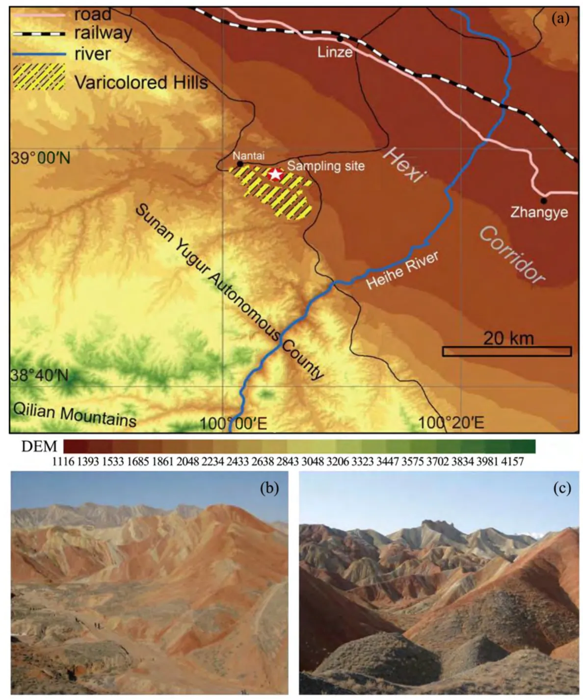
Figure 1 (a)The location of the varicolored hills in the northern foothills of the Qilian Mountains.The map was created by interpretation of Landsat TM images,and the digital elevation model(DEM)is based on the results of the Shuttle Radar Topography Mission(http://www2.jpl.nasa.gov/srtm/);(b,c)Views of the varicolored hills

Figure 2 The varicolored hills(a)and the underground profile(b)in the northern foothills of the Qilian Mountainsof Sunan Yugur Autonomous County in northern China

Table 1 Mean concentrations(µg/g)of major oxides in different kinds of red bed samples
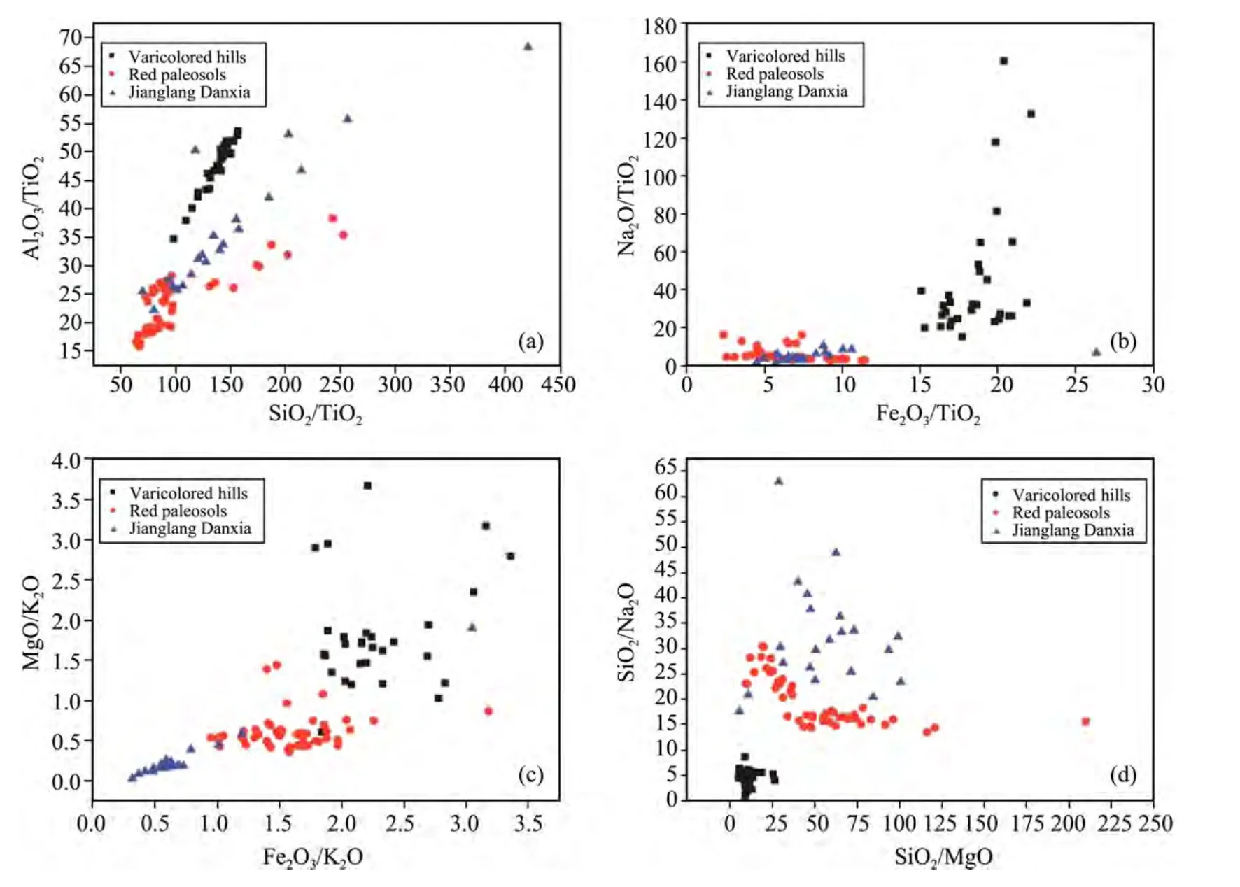
Figure 3 Graphs of the relationships between several combinations of oxide ratios at the study site and in two other red beds:the Jianglang Mountains Danxia landform(Zhang et al.,2010);and red paleosols of the Yaojia Formation(Du et al.,2011)
3.2 Geochemistry of minor elements
The concentrations of minor elements of the varicolored hills and the underground profile are included in Table 2.Compared with the underground profile data,the varicolored hills samples have significantly higher concentrations of Zn,Ga,Br,Rb,and Ce,and significantly lower concentrations of P,Cr,Mn,Co,Cu,As,Sr,Ba,and Nd(t-test,p<0.05).The concentrations of V,Ni,Y,Zr,Nb,La,and Pb did not differ significantly from the values in the underground profile values.
3.3 Changes in the oxide content in the varicolored hills and the underground profiles
To determine the relationship between color and the iron oxide content,we identified samples that had relatively pure coloration.The samples colors were defined according to the Pantone matching system(Figure 4).We found that the oxide content of the varicolored hills(Figure 4a)changes more frequently than that of the underground profile(Figure 4b),which means the oxide content of the sediments is closely related to the color variations.
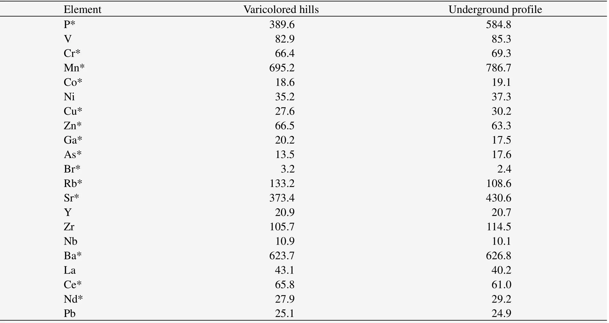
Table 2 The mean minor element contents(µg/g)in samples from the varicolored hills and the underground profile
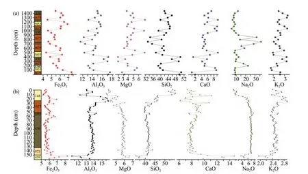
Figure 4 Distribution of the major oxides in(a)the varicolored hills profile and(b)the underground profile.Colors at the left side of the graph represent the color of the strata;number inside the color box represents the color name according to the Pantone matching system.All contents are percentage by weight
3.4 Correlations among the elements
To identify the relationships among the major elements in the samples,we performed a correlation analysis using Pearson's correlation coefficient(r;Table 3 for the varicolored hills;Table 4 for the underground profile).The strong positive correlation between Si and Al in the varicolored hills suggests that the varicolored hills are enriched in aluminosilicate minerals compared with the underground profile.Fe was positively correlated with Si and Al in the varicolored hills which indicates that the minerals in the varicolored hills are generally enriched in Fe.Ca and Sr were also significantly positively correlated in both profiles,but the correlation was stronger in the varicolored hills.

Table 3 Correlations between major elements in the profile from the varicolored hills

Table 4 Correlations between major elements in the underground profile
3.5 Principal-components analysis for the major elements
We performed principal-components analysis to identify the key elements and the corresponding factor loadings in the two profiles(Table 5).For the sample from the varicolored hills,we identified four significant principal components(PCs):PC1,PC2,PC3 and PC4 explained 47.8%,24.3%,10.8%,and 8.0% of the total variance,respectively,for a total of 90.9%.For the varicolored hills sediments,PC1 contained Si,Al,Mg,Ca,Rb,and Sr.PC2 contained Na and Ti.PC3 contained K and Zr and PC4 contained Ba.The value of the Kaiser–Meyer–Olkin(KMO)measure of sampling adequacy was 0.619,which indicates that the dataset can be used to perform factor analysis.
3.6 Source type of the varicolored hills
To determine whether the varicolored hills were of terrestrial or oceanic origin,we calculated three indices of the sedimentary environment in which the sediments formed(Table 6).The results suggest that the varicolored hill sediments and those of the underground profile both mainly originated authigenically after the deposition of terrestrial detritus.That's largely because the palaeocontinental crust in the Qilian Mountains area started to close since the middle Paleozic,and terrestrial sediments formed during the Cretaceous(Feng and Wu,1992;Penget al.,2011).
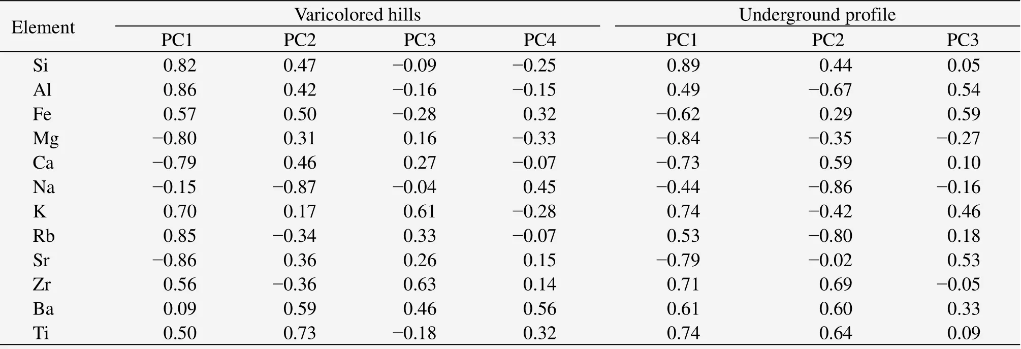
Table 5 Principal-components analysis for the samples from the varicolored hills and from the underground profile
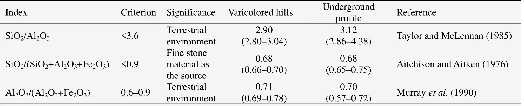
Table 6 Indices for the major oxides in the profiles that provide evidence for the environment in which the varicolored hills and the underground profile developed
4 Discussion and conclusions
In this study,we analyzed the material composition,lithological characteristics,and source material types of sediment samples from the varicolored hills formation in the northern foothills of the Qilian Mountains,in the Hexi Corridor of the Sunan Yugur Autonomous County,China.We found that the elemental composition of these sediments was distinct from those of the Jianglang Danxia landform and the red paleosols of the Yaojia Formation in the Songliao Basin,possibly because the varicolored hills developed from mudstone and sandstone instead of the harder conglomerates from which most other Danxia landforms developed(Huang and Chen,2003).We found that the samples were distinct from those of the other red bed samples based on our comparisons of four pairs of oxide ratios,suggesting that the varicolored hills represent a distinct type of red bed deposit.The correlations among elements identify the relationships among the major elements in the samples and in the principal-components results identify the key elements and the corresponding factor loadings in the varied colored hills.Our calculation of three indices based on oxide ratios suggests that the varicolored hills developed from authigenically terrestrial detritus rather than marine deposits.This conclusion agrees with the results of Zhang and Cui(2007).
The major oxides that make up the varicolored hills formation in the northern foothills of the Qilian Mountains in the Hexi Corridor of the Sunan Yugur Autonomous County are SiO2,Al2O3and Na2O.The different colors in the varicolored hills of this landform resulted from differences in oxidation-reduction reaction during and after their deposition.Calculating three indices for oxide ratios suggests that the varicolored hills developed from terrestrial detritus rather than from aquatic deposits.
This work was supported by the National Natural Science Foundation of China(41101006)and National Natural Science Foundation of China(41272191).
Aitchison J,Aitken CGG,1976.Multivariate binary discrimination by the kernel method.Biometrika,63(3):413–420.DOI:10.1093/biomet/63.3.413.
Boulay S,Colin C,Trentesaux A,et al.,2003.Mineralogy and Sedimentology of Pleistocene Sediment in the South China Sea(ODP Site 1144).In:Prell WL,Wang P,Blum P,et al.(eds.).Proceedings of the Ocean Drilling Program,Scientific Results,184:1–21.Available at:http://www-odp.tamu.edu/publications/184_SR/VOLUME/CHAPTERS/211.PDF.
Cai YF,Li X,Pan YG,et al.,2008.The color-causing mechanism of Mn2+and Fe3+:evidence from the Italian Cretaceous pelagic red limestones.Acta Geologica Sinica,82(1):133–138.
Chen GD,1935.Red rock series of Guangdong.Neo-confucianism Quarterly Journal of Guangzhou Sun Yat-sen University(Natural Science Edition),6(4):783–784.
Deaton BC,Balsam WL,1991.Visible spectroscopy—a rapid method for determining hematite and goethite concentration in geological materials.Journal of Sediment Research,61(4):628–632.DOI:10.1306/D4267794-2B26-11D7-8648000102C1865D.
Dill HG,Kadirov O,Tsoy Y,et al.,2007.Palaeogeography of Neogene red bed sequences along the Aksa-Ata River in the Parkent–Nurekata intermontane basin(Tien Shan Mountains,Uzbekistan):With special reference to the magnetic susceptibility of siliciclastic rocks.Journal of Asian Earth Sciences,29(5–6):960–977.DOI:10.1016/j.jseaes.2006.07.006.
Du XB,Xie XN,Lu YC,et al.,2011.Distribution of continental red paleosols and their forming mechanisms in the Late Cretaceous Yaojia Formation of the Songliao Basin,NE China.Cretaceous Research,32(2):244–257.DOI:10.1016/j.cretres.2010.12.010.
Eren M,Kadir S,1999.Colour origin of upper Cretaceous pelagic red sediments within the Eastern Pontides,northeast Turkey.International Journal of Earth Sciences,88(3):593–595.DOI:10.1007/s005310050287.
Feng YM,Wu HQ,1992.Tectonic evolution of North Qilian Mountains and its neighbourhood since Paleozoic.Northwest Geoscience,13(2):61–73.
Hofmann A,Tourani A,Gaupp R,2000.Cyclicity of Triassic to Lower Jurassic continental red beds of the Argana Valley,Morocco:implications for palaeoclimate and basin evolution.Palaeogeography,Palaeoclimatology,Palaeoecology,161(1):229–266.DOI:10.1016/S0031-0182(00)00125-5.
Hu XM,Jansa L,Wang CS,et al.,2005.Upper Cretaceous oceanic red beds(CORBs)in the Tethys:occurrences,lithofacies,age,and environments.Cretaceous Research,26(1):3–20.DOI:10.1016/j.cretres.2004.11.011.
Hu XM,Wagreich M,Yilmaz IO,2012.Marine rapid environmental/climatic change in the Cretaceous greenhouse world.Cretaceous Research,38:1–6.DOI:10.1016/j.cretres.2012.04.012.
Huang J,2004.Quantitative survey of several important issues concerning the formation of the Danxia landforms.Tropical Geography,24(2):127–130.
Huang J,Chen ZJ,2003.The discussion on the definition and classification to Danxia Landform.Economic Geography,23:6–11.
Kodama K,Takeda T,2002.Paleomagnetism of mid-Cretaceous red beds in west-central Kyushu Island,southwest Japan:paleoposition of Cretaceous sedimentary basins along the eastern margin of Asia.Earth and Planetary Science Letters,201(1):233–246.DOI:10.1016/S0012-821X(02)00691-X.
Li GB,Jiang GQ,Wan XQ,2011.The age of the Chuangde Formation in Kangmar,southern Tibet of China:Implications for the origin of Cretaceous oceanic red beds(CORBs)in the northern Tethyan Himalaya.Sedimentary Geology,235(1–2):111–121.DOI:10.1016/j.sedgeo.2010.04.011.
Li GB,Jiang GQ,Hu XM,et al.,2009.New biostratigraphic data from the Cretaceous Bolinxiala Formation in Zanda,southwestern Tibet of China,and their paleogeographic and paleoceanographic implications.Cretaceous Research,30(4):1005–1018.DOI:10.1016/j.cretres.2009.03.005.
Li XH,Wang CS,Hu XM,2005.Stratigraphy of deep-water Cretaceous deposits in Gyangze,southern Tibet,China.Cretaceous Research,26(1):33–41.DOI:10.1016/j.cretres.2004.11.004.
Li X,Cai YF,Xue JY,2009.Color genesis of red shales in Cretaceous marine red beds from Gyangze,Southern Tibet.Acta Mineralogica Sinica,29(3):283–290.
Liu SR,Liu RH,2003.On the conception of Danxia Landform.Journal of Moutain Science,21(6):669–674.
Murray RW,Ten Brink MRB,Jones DL,et al.,1990.Rare earth elements as indicators of different marine depositional environments in chert and shale.Geology,18(3):268–271.DOI:10.1130/0091-7613(1990)018<0268:REEAIO>2.3.CO;2.
Neuhuber S,Wagreich M,Wendler I,et al.,2007.Turonian oceanic red beds in the Eastern Alps:concepts for palaeoceanographic changes in the Mediterranean Tethys.Palaeogeography,Palaeoclimatology,Palaeoecology,251:222–238.DOI:10.1016/j.palaeo.2007.03.049.
Oliva-Urcia B,Pueyo EL,Larrasoaña JC,et al.,2012.New and revisited paleomagnetic data from Permian–Triassic red beds:two kinematic domains in the west-central Pyrenees.Tectonophysics,522–523:158–175.DOI:10.1016/j.tecto.2011.11.023.
Parcerisa D,Gómez-Gras D,Travé A,et al.,2006.Fe and Mn in calcites cementing red beds:a record of oxidation–reduction conditions:examples from the Catalan Coastal Ranges(NE Spain).Journal of Geochemical Exploration,89(1–2):318–321.DOI:10.1016/j.gexplo.2005.11.081.
Peng H,2000.A survey of the Danxia landform research in China.Scientia Geographica Sinica,20(3):203–211.
Peng N,Kuang HW,Liu YQ,2011.Sedimentary evolution and palaeogeography of the early Cretaceous basins from the northern Qilian Mountains to Jiuxi areas.Earth Science Frontiers,18(4):77–87.
Qiang M,Chen F,Wang Z,et al.,2010.Aeolian deposits at the southeastern margin of the Tengger Desert(China):implications for surface wind strength in the Asian dust source area over the past 20,000 years.Palaeogeography,Palaeoclimatology,Palaeoecology,286:66–80.
Refaat AA,Imam MM,1999.The Tayiba red beds:transitional marine-continental deposits in the precursor Suez Rift,Sinai,Egypt.Journal of Asian Earth Sciences,28(3):487–506.DOI:http://dx.doi.org/10.1016/S0899-5362(99)00029-9.
Sheldon ND,Tabor NJ,2009.Quantitative paleoenvironmental and paleoclimatic reconstruction using paleosols.Earth-Science Reviews,95(1–2):1–52.DOI:10.1016/j.earscirev.2009.03.004.
Tan XD,Kodama KP,Gilder S,et al.,2007.Rock magnetic evidence for inclination shallowing in the Passaic Formation red beds from the Newark basin and a systematic bias of the Late Triassic apparent polar wander path for North America.Earth and Planetary Science Letters,254(3–4):345–357.DOI:10.1016/j.epsl.2006.11.043.
Taylor SR,McLennan SM(eds.),1985.The Continental Crust:Its Composition and Evolution.Blackwell Scientific Pub.,Palo Alto,CA.
Uno K,Furukawa K,2005.Timing of remanent magnetization acquisition in red beds:a case study from a syn-folding sedimentary basin.Tectonophysics,406(1–2):67–80.DOI:10.1016/j.tecto.2005.06.003.
Wang CS,Hu XM,Sarti M,et al.,2005.Upper Cretaceous oceanic red beds in southern Tibet:a major change from anoxic to oxic,deep-sea environments.Cretaceous Research,26(1):21–32.DOI:10.1016/j.cretres.2004.11.010.
Wang CS,Hu XM,Huang YJ,et al.,2011.Cretaceous oceanic red beds as possible consequence of oceanic anoxic events.Sedimentary Geology,235(1–2):27–37.DOI:10.1016/j.sedgeo.2010.06.025.
Zhang C,Sun Z,2012.Determination of major and minor elements in limited samples measurement based on x-ray fluorescence spectrometry.Journal of Desert Research,32(5):1263–1267.
Zhang GS,Zhu C,Yu JB,et al.,2010.Experimental study on lithological characteristic with Danxia landform,Jianglang Mountain,Zhejiang Province.Journal of Mountain Science,28(3):301–312.DOI:10.16089/j.cnki.1008-2786.2010.03.003.
Zhang H,Cui Z,2007.Landscape character and forming of Danxia landform and color hill in Zhangye of Gansu Province.Journal of Desert Research,27(6):942–945.
 Sciences in Cold and Arid Regions2015年3期
- Sciences in Cold and Arid Regions的其它文章
- The characteristics of oasis urban expansion and drive mechanism analysis:a case study on Ganzhou District in Hexi Corridor,China
- Characterizing changes in ecosystem service values in China's eastern Loess Plateau
- Aesthetic evaluation of yardang landforms landscape:the Dunhuang Yardang National Geo-park example
- Characterizing stand structure in a spruce forests:effects of sampling protocols
- Biomass and water partitioning in two age-related Caragana korshinskii plantations in desert steppe,northern China
- Comparative studies on leaf epidermal micromorphology and mesophyll structure of Elaeagnus angustifoliaL.in two different regions of desert habitat