海水速度差异对中深层偏移成像的影响分析
2015-04-17 03:56:38韩复兴孙建国王坤刘嘉蕾
地球物理学报 2015年9期
韩复兴, 孙建国*, 王坤, 刘嘉蕾
1 吉林大学地球探测科学与技术学院波动理论与成像技术实验室, 长春 130026 2 吉林交通职业技术学院, 长春 130012
海水速度差异对中深层偏移成像的影响分析
韩复兴1, 孙建国1*, 王坤2, 刘嘉蕾1
1 吉林大学地球探测科学与技术学院波动理论与成像技术实验室, 长春 130026 2 吉林交通职业技术学院, 长春 130012
本文针对深水环境下中深层偏移成像质量差的问题,考虑海水速度变化对中深层偏移成像质量的影响,从在大水深中加入深海声道模型入手,分析在偏移成像当中海水速度的不同选取对水平层状介质、倾斜层介质以及较复杂介质模型偏移成像质量的影响,通过在同一模型上改变海水速度进行成像,分析中深层成像效果可以得出:在大水深反射资料数据处理当中应该考虑真实的海水速度进行成像处理,否则会由于海水速度的选取不当而造成偏移成像层位的空间位置和中深层层位几何形态的变化.
海水速度; 中深层; 偏移成像
1 引言
不管是陆地地震勘探还是海洋地震勘探,速度对反射资料叠前深度偏移来说都是一个重要的参数,速度模型的微小差异直接影响着偏移的最终效果( Herron,2000;杨俊等,2006;潘宏勋和方伍宝,2010).对于海洋地球物理勘探来说,在以往的反射地震资料处理当,不管是进行几何扩散校正还是偏移成像处理都是将海水的传播速度取为常数,这种处理方式对于海水深度比较浅的区域来说,不会带来很大的影响,但是对于海水深度在几千米的深海区域,由于地震波在海水层当中的传播速度受到温度、压力、盐度、季节、洋流等因素的影响,会造成声速分布的层状结构,从而形成海洋中的声速梯度(冯士筰,1999; Jones,1999),致使在偏移成像当中与选取常数的速度模型相比,海水部分的速度会发生相应的变化,从而影响速度模型的准确性,最终影响偏移成像质量.
关于海水速度变化对波场传播以及偏移像场的影响,Dyk和Swainson (1953)探讨深水区中声波的传播速度和射线传播路径的问题,得出深水中声波传播速度的变化对射线路径有着非常重要的影响,Nafe和Drake (1957)给出了纵波和横波速度在浅水区和深水区随深度的线性变化关系,证明海水中声波速度在浅水区和深水区存在不同的差异,Brian(1999)指出了海水速度变化是世界各地的深水问题中一直存在的一个问题,Mackay等(2003)在海水速度变化对地震数据处理的影响一文中讨论了海水速度变化对地震波同向轴的影响,得出海水速度随时间和季节而引起的速度差异很对不同时间采集得到的地震数据引起同向轴的错动,同年Alexandre(2003)从水声学的基本原理出发单一考虑温度、盐度以及海水深度的变化对地震波在海水中的传播速度的影响,通过深水勘探和实时油藏监测的模拟地震记录结果发现由于海水速度的变化,会对地震波走时和振幅带来很大的影响,且这种影响是不可忽略的,Jones等(2010)通过研究海水层速度变化对深水地震勘探成像的影响发现海水速度的自然变化会降低2D、3D以及4D 海底地震反射数据的成像品质,宋洋等(2010)和黄兴辉等(2011)分别利用海洋实测的地震数据反演出了海水的温盐结构,通过反演结果可以得出海水速度的变化受温度、盐度以及压强的影响呈现梯度变化,这种变化曲线同深海声道模型非常的近似,韩复兴等(2012)从物理海洋学中海水声波速度随温度、盐度和深度变化的经验公式出发,考虑其相对应数值的变化规律,建立相对应的海洋深水介质速度模型,并在此基础上讨论了海水速度变化对地震波走时、射线路径以及振幅的影响,得出在地震勘探数据处理当中,不能简单的将地震波速度取为常数进行处理.
中国海洋油气勘探的重点区域主要集中在南海北部琼东南盆地深水区,由于该区域地质构造相对复杂,存在大范围的水深突然加大,海水深度变化从几百米到几千米,由于海水深度的变化比较大,那么在数据处理当中如果不考虑海水速度的变化还将海水的传播速度取为常数进行处理,必然会造成地震波走时、射线路径和振幅值偏离真实的数值(韩复兴等,2012),并最终影响偏移剖面的成像结果.为了能对这种影响进行定性描述,本文将首先从理论的角度分析海水速度的选取对成像的影响,接着通过实际资料获取南海某区的水深资料,根据所获取的深水资料分别建立大水深环境下的层状介质模型、倾斜介质模型以及海底较复杂的介质模型,在这些介质模型的海水部分加入深海声道(Munk,1974),通过波场数值模拟获得加入深海声道的波场记录,然后改变不同的海水速度进行成像分析,说明海水速度差异对成像质量的影响.
2 地震波速度误差对成像的影响分析
地震资料叠前深度偏移是解决地下复杂构造精确成像的有效手段,而偏移成像的质量取决于速度模型的准确性.为了说明海水速度差异对偏移成像的影响,设在海水中地震波实际传播速度为v,偏移成像中应用的偏移速度为vm,设纵波在海水中的传播路径如图1所示,假设先不考虑偏移成像点位与真实反射点位在横向上的变化,地震波从震源点S出发经过地下层位反射点M到达偏移距为x的接收点R的真实走时可以表示为x2+4H2=(vt(x,z))2,即:
(1)
其中t0为地震波自激自收时双程走时,H为M点距离地表的垂直距离.设偏移距为x,偏移速度为vm对应的反射波时距曲线方程为
x2+4h(z)2=(vmt(x,z))2,
(2)
对于不同的炮检距x,(2)式可以表示为
(3)
其中h(z)为深度方向z的函数,是偏移速度vm所对应的成像点深度.
(4)

R.
(5)

图1 偏移成像射线路径走时计算Fig.1 Calculated travel time and ray path for migration imaging
从公式(4)可以看出,当偏移速度vm与实际速度v相同时,即(5)式中R=0时,h(z)=h(0,z)=H,此时的偏移结果没有误差,但由于对地震波在海水中传播的真实速度v无法准确描述,故在偏移成像中只能用偏移速度vm近似于实际速度v,这必然会引起成像点的位置和形状的变化.根据公式(5)假设海水层的传播速度v取均方根速度1500 m·s-1,偏移距x从0到3000 m,成像点M的深度H=1000 m,如果偏移速度取vm=1450 m·s-1,即偏移速度vm小于海水的真实速度v时,成像点的轨迹为一开口向上的双曲线(图2a),成像点深度小于真实深度;而当偏移速度取vm=1580 m·s-1,即偏移速度vm大于海水的真实速度v时,成像点的轨迹为一开口向下的双曲线 (图2b),成像点深度大于真实点深度.当偏移距x=1000 m固定时,在大水深里面加入声道时,实际的海水速度v从1450 m·s-1变化到1560 m·s-1,那么按照常规处理取偏移速度vm=1500 m·s-1进行成像处理对成像位置的影响如图2c所示.通过图2可见偏移速度的差异直接影响成像点位置的准确度.下面就以水平层状介质和倾斜层介质为例说明海水速度误差对偏移成像的影响.
3 海水速度变化对水平层状介质偏移的影响
在大水深环境下,地震波在海水中的传播速度受温度、压力、盐度等因素不均匀分布的影响,会造成声速分布的层状结构,从而形成海洋中的深海声道,它是由温度垂直分布的“三层结构”所形成(munk,1974).在声道上方,海水表面由于受到阳光照射水温较高,因此海水声速比较大;在声道下面的深海内部,水温度较低且稳定,但随着深度的增加海水静压力不断增大,造成海水声速v随海水深度增加,呈现洋海内部的声速正梯度(v随深度增加)变化.于是就形成海水速度随深度变化的深海声速剖面图.
为了说明海水速度差异对中深层偏移成像的影响,建立水平层状介质速度模型,模型大小为3200×3500,网格间距为2 m×2 m,海水深度为3800 m(海水深度通过南海某区原始采集数据的偏移剖面获得),海水下面加入4层地层,层速度为v2=2300 m·s-1,v3=2800 m·s-1,v4=3250 m·s-1,v5=4000 m·s-1,模型如图3a所示.在3800 m的海水里面加入声道进行波场数值模拟,数值模拟炮点位置位于(1600,4),每炮共640道接收,道间距为10 m,在海水速度变化的模型上获得的单炮模拟记录如图3b所示,通过与原始资料对比分析波场记录发现,加入深海声道的模型所获得波场记录与原始实测地震记录在时间样点上更加符合,说明对于深水勘探,海水声道的存在确实对波场有着重要的影响.
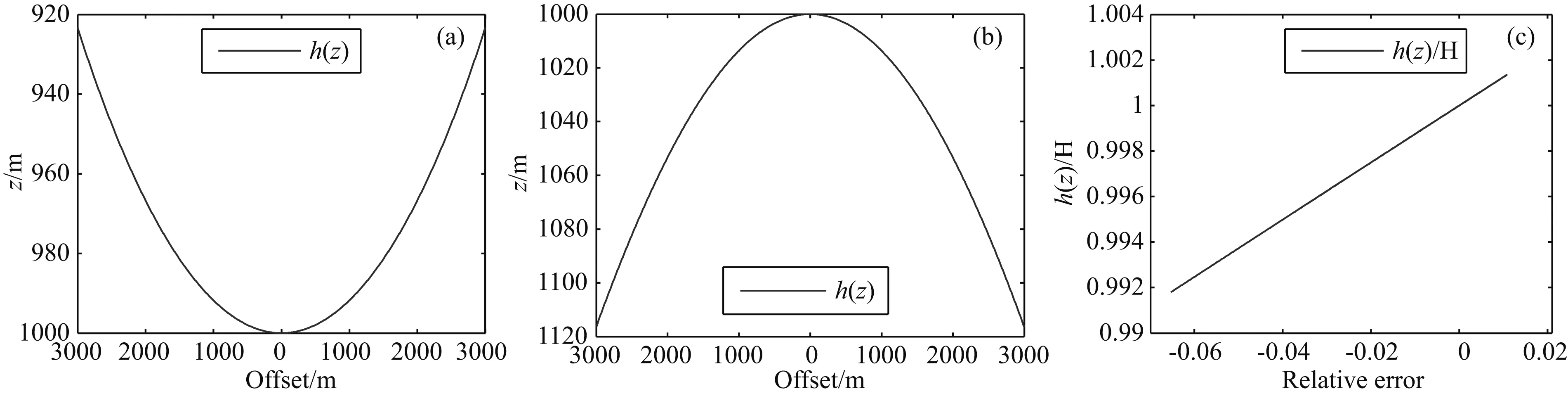
图2 偏移速度与真实速度差异对成像点位置的影响(a)偏移速度小于真实速度的成像点轨迹;(b)偏移速度大于真实速度的成像点轨迹;(c)偏移距固定时,速度差异引起的成像点位相对误差.Fig.2 Influence of differences between migration velocity and real velocity on imaging position(a) Imaging point trajectory of migration velocity less than the true velocity; (b) Imaging point trajectory of migration velocity is greater than the true velocity; (c) Relative error of the imaging position caused by velocity difference when offset fixed.

图3 水平层状介质速度模型(a)及波场模拟记录(b)Fig.3 Horizontal layered velocity model (a) and wave field simulation records (b)
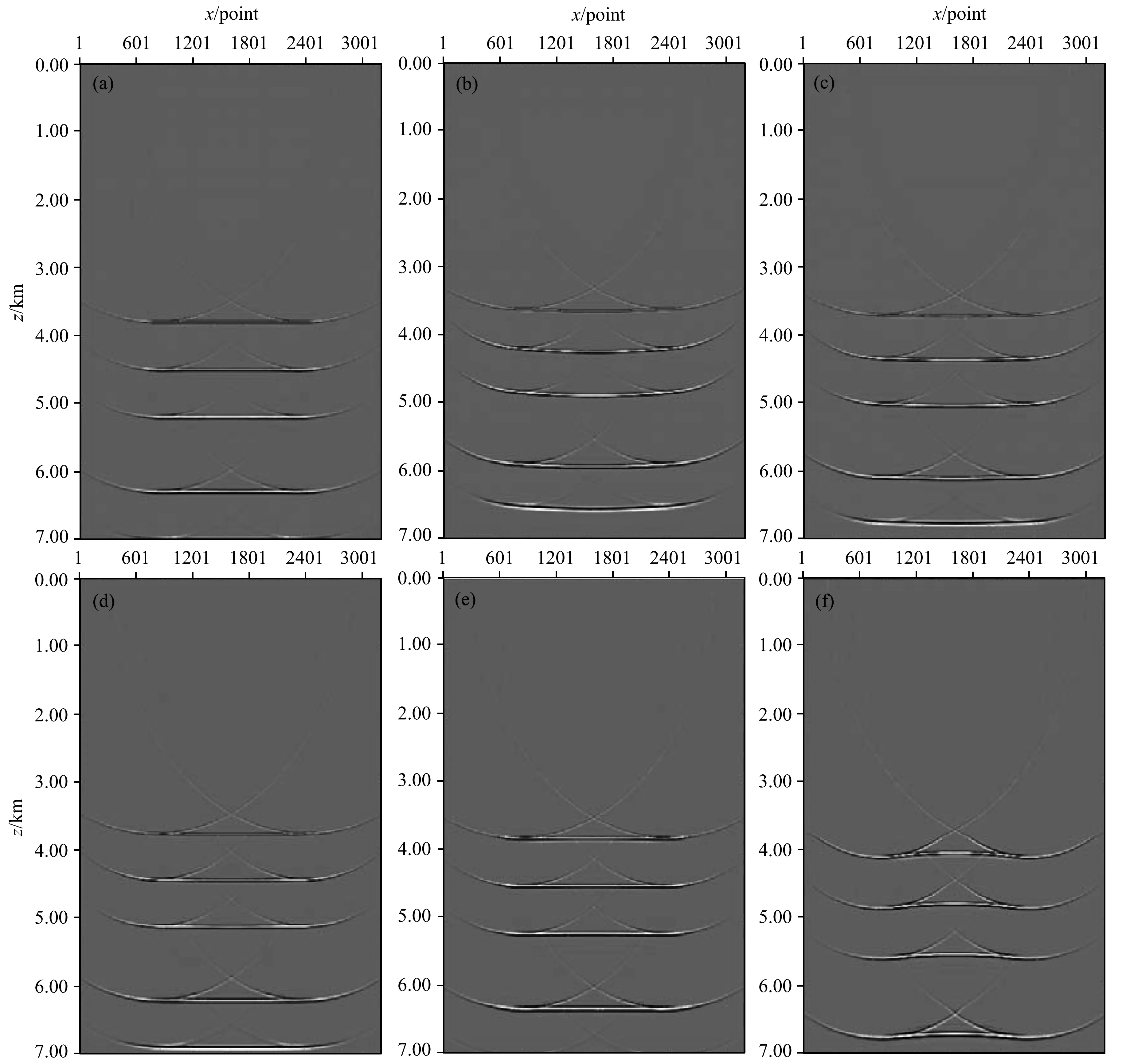
图4 水平层状介质海水速度取不同值时的偏移结果对比(a) 真实速度所得偏移结果; (b) v=1450 m·s-1所得偏移结果; (c) v=1480 m·s-1所得偏移结果; (d) v=1500 m·s-1所得偏移结果; (e) v=1520 m·s-1所得偏移结果; (f) v=1580 m·s-1所得偏移结果.Fig.4 The migration results when different values of the seawater velocity in horizontally layered medium(a) Migration results obtained by real velocity; (b) Migration results obtained by v=1450 m·s-1; (c) Migration results obtained by v=1480 m·s-1; (d) Migration results obtained by v=1500 m·s-1; (e) Migration results obtained by v=1520 m·s-1;(f) Migration results obtained by v=1580 m·s-1.
在加入深海声道速度模型通过波场数值模拟所获得的记录上,分别选海水速度为常速v=1450 m·s-1、v=1480 m·s-1、v=1500 m·s-1、v=1520 m·s-1、v=1580 m·s-1进行偏移成像分析,所获得偏移剖面与真实的海水速度变化模型上所得到的偏移结果对比如图4所示.通过对比发现,海水速度取v=1450 m·s-1时,偏移剖面与真实速度模型相比明显上移,且两端有向上弯曲的趋势,说明偏移速度较小,随着偏移速度的增大,上移现象逐渐减小,当海水速度取v=1520 m·s-1时与原模型对应最好,随着偏移速度的增大,当海水速度取常v=1580 m·s-1时,偏移剖面与真实速度模型相比明显向下移动,且两端向下弯曲趋势明显,不符合实际,说明偏移速度较大.通过以上分析可以发现,对于层状介质模型来说,较小或者较大的偏移速度选取对成像后的层位会带来上下的错动,因此对于深水勘探地震资料在偏移成像的处理当中,必须首先结合实际情况确认海水速度对波场传播的影响,然后通过数值模拟分析选取合适的偏移速度进行成像,这样才能取得好的成像效果.
4 海水速度变化对倾斜层介质偏移的影响
倾斜层模型大小为3200×3500,网格间距为2 m×2 m,海水深度从2000 m到3800 m,海水下面加入4层倾斜地层,倾斜层速度为v2=2300 m·s-1,v3=2800 m·s-1,v4=3250 m·s-1,v5=4000 m·s-1,模型如图5a所示.分别在2000~3800 m的海水里面加入声道和不加声道进行波场数值模拟,数值模拟炮点位置位于(1600,4),每炮共640道接收,道间距为10 m,在海水速度变化的模型上获得的单炮模拟记录如图5b所示.
在该模拟记录上,分别选海水的偏移速度为变化的和v=1450 m·s-1、v=1480 m·s-1、v=1500 m·s-1、v=1520 m·s-1、v=1580 m·s-1进行偏移成像,所获得偏移剖面对比如图6所示.通过对比发现,偏移速度取v=1450 m·s-1时,偏移剖面与真实速度模型相比明显上移,且成像质量不高,原底层水平层成像后向上切斜,成像失真,说明偏移速度较小,随着偏移速度的增大,上移现象逐渐减小,当偏移速度取v=1520 m·s-1时与原模型对应最好,随着偏移速度的增大,当取常v=1580 m·s-1时,偏移剖面与真实速度模型相比明显向下移动,且底层水平层成像后向下切斜,成像失真,不符合实际,说明偏移速度较大.通过以上分析可以发现,对于倾斜层来说,海水速度的变化不但影响成像层位的上下错动,而且影响层位的空间变化,较小或者较大的偏移速度都会对底层的成像带来影响.
5 实际资料分析
下面建立海底较为复杂的大水深速度模型说明海水速度差异对偏移成像中深层的影响.模型大小为3200×3000,网格间距为2.5 m×2.5 m,海水深度3750 m,海水下面地层起伏变化,速度变化从2900 m·s-1到4900 m·s-1,在海水里面加入声道进行波场数值模拟,数值模拟炮点位置位于(1600,4),每炮共640道接收,道间距为12.5 m,在海水速度变化的模型上获得的单炮模拟记录如图7所示.
在该模拟记录上,分别选海水的偏移速度为变化的和v=1450 m·s-1、v=1480 m·s-1、v=1500 m·s-1、v=1520 m·s-1、v=1580 m·s-1进行偏移成像,所获得偏移剖面对比如图8所示.通过对比发现,偏移速度取v=1450 m·s-1时,偏移剖面与真实速度模型相比明显上移,海水底下两层模糊不清且成像层与原速度模型相比发生严重畸变,成像失真,说明偏移速度较小,随着偏移速度的增大,上移现象逐渐减小,成像质量有所改观,当偏移速度取v=1520 m·s-1时与原模型对应最好,当选较大的偏移速度v=1580 m·s-1时,偏移剖面与真实速度模型相比明显向下移动,层位与真实速度模型相比严重失真,不符合实际.通过以上分析可以发现,对于复杂的大水深模型来说,海水速度的变化不但影响成像层位的上下错动,而且影响层位的空间变化,较小或者较大的偏移速度都会对底层的成像带来影响.

图5 倾斜层状介质速度模型(a)及波场模拟记录(b)Fig.5 Tilt layered medium velocity model (a) and wave field simulation records (b)
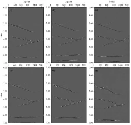
图6 倾斜层海水速度取不同值时的偏移结果对比(a) 真实速度所得偏移结果;(b) v=1450 m·s-1所得偏移结果;(c) v=1480 m·s-1所得偏移结果;(d) v=1500 m·s-1所得偏移结果;(e) v=1520 m·s-1所得偏移结果;(f) v=1580 m·s-1所得偏移结果.Fig.6 Migration results from different seawater velocities in tilt layered medium model(a) Migration results obtained by real velocity;(b) Migration results obtained by v=1450 m·s-1;(c) Migration results obtained by v=1480 m·s-1; (d) Migration results obtained by v=1500 m·s-1; (e) Migration results obtained by v=1520 m·s-1;(f) Migration results obtained by v=1580 m·s-1.

图7 海底较复杂介质速度模型(a)及波场模拟记录(b)Fig.7 Complex seabed Medium velocity model (a) and wave field simulation records (b)
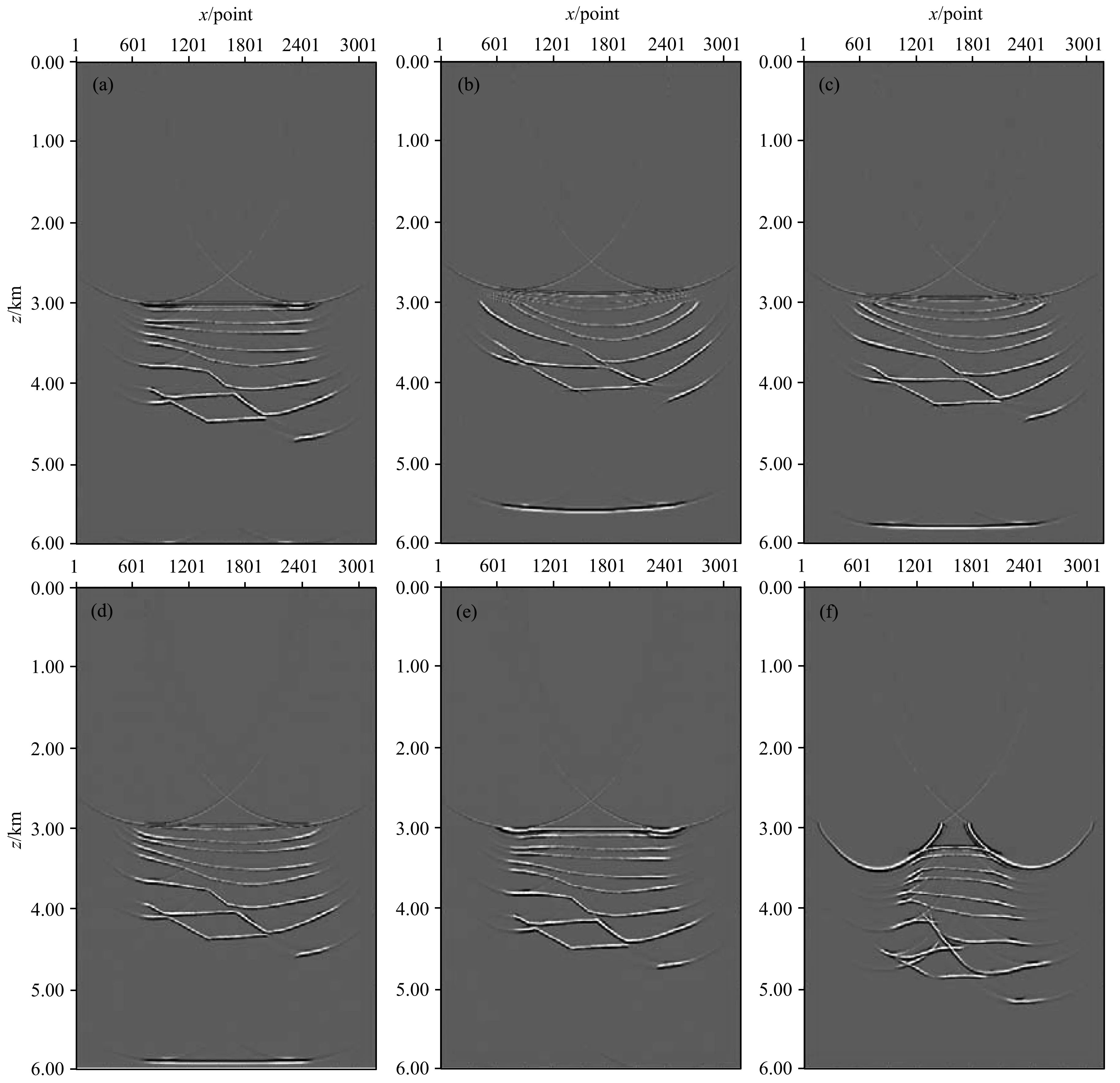
图8 海底较复杂模型海水速度取不同值时的偏移结果对比(a) 真实速度所得偏移结果;(b) v=1450 m·s-1所得偏移结果;(c) v=1480 m·s-1所得偏移结果;(d) v=1500 m·s-1所得偏移结果;(e) v=1520 m·s-1所得偏移结果;(f) v=1580 m·s-1所得偏移结果.Fig.8 Migration results from different seawater velocities in complex seabed medium model(a) Migration results obtained by real velocity;(b) Migration results obtained by v=1450 m·s-1;(c) Migration results obtained by v=1480 m·s-1; (d) Migration results obtained by v=1500 m·s-1; (e) Migration results obtained by v=1520 m·s-1;(f) Migration results obtained by v=1580 m·s-1.
6 结论
传统的海洋地震反射资料偏移成像处理当中都是将海水速度取为常数,然而在大水深环境下,海水的速度随温度、压力、盐度等因素不均匀分布会发生相应的变化,从而影响偏移成像中速度模型的准确度.速度模型的准确度对深度偏移成像质量有着至关重要的影响,本文针对南海大水深环境下中深层偏移成像质量差的问题,考虑海水速度变化对中深层成像质量的影响,从简单的层状介质模型、倾斜介质模型到海底较复杂介质模型分析当中可以发现,首先海水速度的选取对偏移成像层位的上下位置有着一定的影响,当偏移速度较小时,层位明显上移,当偏移速度较大时,层位明显下移;其次,海水速度的选取对层位的形态也有着重要的影响,通过分析对比可以看出,较小的偏移速度致使层位有向上弯曲的趋势,较大的偏移速度会使层位有向下弯曲的趋势;最后通过在海底较复杂的介质模型上海水速度选取不同的数值分析当中可以发现,偏移速度的选取直接影响到海水底层的成像质量,较小或者较大的偏移速度都使海水底层成像变得模糊不清,难以分辨.因此在以后海洋反射资料成像处理当中,不能简单的取海水速度为常数进行成像处理.
Alexandre B, Colin M. 2003. Seawater velocity variations and real-time reservoir monitoring.TheLeadingEdge, 22(4): 351-355.
Brian B. 1999. Deepwater problems around the world.TheLeadingEdge, 18(4): 488-494.
Dyk K, Swainson O W. 1953. The velocity and ray paths of sound waves in deep sea water.Geophysics, 18(1): 75-103.
Feng S Z, Li F Q, Li S Q. 1999. An Introduction to Marine Science (in Chinese). Beijing: Higher Education Press, 266-270.
Han F X, Sun J G, Wang K. 2012. The influence of sea water velocity variation on seismic traveltimes, ray paths, and amplitude.AppliedGeophysics, 9(3): 319-325.
Herron D A. 2000. Pitfalls in seismic interpretation: depth migration artifacts.TheLeadingEdge, 19(9): 1016-1017.
Huang X H, Song H B, Pinheiro L M, et al. 2011. Ocean temperature and salinity distributions inverted from combined reflection seismic and XBT data.ChineseJ.Geophys. (in Chinese), 54(5): 1293-1300. Jones E J W. 1999. Marine Geophysics. London: University College London, 67-68.
Jones S M, Sutton C, Hardy R J J, et al. 2010. Seismic imaging of variable water layer sound speed in Rockall Trough, NE Atlantic and implications for seismic surveying in deep water.PetroleumGeologyConferenceSeries, 7: 549-558.
MacKay S, Fried J, Carvill C. 2003. The impact of water-velocity variations on deepwater seismic data.TheLeadingEdge, 22(4): 344-350.
Munk M. 1974. Sound Channel in an exponentially Stratified Ocean, with application to sofar.J.Acoust.Soc.Am., 55(2): 220-227. Nafe J, Drake C. 1957. Variation with depth in shallow and deep water marine sediments of porosity, density and the velocities of compressional and shear waves.Geophysics, 22(3): 523-552.
Pan H X, Fang W B. 2010. Effect of inexact velocity model on prestack depth migration imaging.ComputingTechniquesforGeophysicalandGeochemicalExploration(in Chinese), 32(1): 66-72.
Song Y, Song H B, Chen L, et al. 2010. Sea water thermohaline structure inversion from seismic data.ChineseJ.Geophys. (in Chinese), 53(11): 2696-2702.
Yang J, He Z H, Huang D J. 2006. The influence of velocity model to seismic wavefield migration imaging.ComputingTechniquesforGeophysicalandGeochemicalExploration(in Chinese), 28 (2): 113-116.
附中文参考文献
冯士筰, 李凤岐, 李少菁. 1999. 海洋科学导论. 北京: 高等教育出版社, 266-270.
韩复兴, 孙建国, 王坤. 2012. 海水速度变化对地震波走时、射线路径及振幅的影响. 应用地球物理, 9(3): 319-325.
黄兴辉, 宋海斌, Pinheiro L M等. 2011. 利用反射地震数据和XBT数据联合反演海水的温盐分布. 地球物理学报, 54(5): 1293-1300.
潘宏勋, 方伍宝. 2010. 速度模型误差给叠前深度偏移成像带来的假象. 物探化探计算技术, 32(1): 66-72.
宋洋, 宋海斌, 陈林等. 2010. 利用地震数据反演海水温盐结构. 地球物理学报, 53(11): 2696-2702.
杨俊, 贺振华, 黄德济. 2006. 速度模型对地震波场偏移成像的影响. 物探化探计算技术, 28(2): 113-116.
(本文编辑 张正峰)
Analysis of the influence of sea velocity difference on migration imaging in middle and deep layers
HAN Fu-Xing1, SUN Jian-Guo1*, WANG Kun2, LIU Jia-Lei1
1TheoryofMinistryforLandandResources,CollegeforGeoexplorationScienceTechnology,JilinUniversity,Changchun130026,China2JilinCommunicationsPolytechnic,Changchun130012,China
In view of the problem of the poor quality of migration imaging in deep water environments, by analyzing the influence of water velocity change on wave propagation and migration imaging results, this work attempted to explain the effect of water velocity change on the geometry change of spatial location of migration imaging in middle and deep layers.We established a horizontal layered model, tilt-layer dielectric as well as more complex medium models. We added the deep channel model in the large-depth water (water depth 3800 m), and obtained the wave field recorded in the deep channel model by using wave field numerical simulation. We used the seismic records obtained as the input of the wave field, selected the seawater speeds as constantv=1450 m·s-1,v=1480 m·s-1,v=1500 m·s-1,v=1520 m·s-1,v=1580 m·s-1in migration imaging separately. Then we compared the imaging results with the migration results adding deep-sea channel to explain the effect of different sea water velocities on deep migration imaging quality.By comparing migration results from the combination of the deep channel model, the horizontally layered model, tilt-layer dielectric as well as more complex medium model, we found when the migration velocity is taken asv=1450 m·s-1, the offset profile obviously moves up compared with the true velocity model, the medium is vague beneath the ocean, and the imaging layer is distorted compared with the original velocity model, implying the smaller migration velocity can lead to imaging distortion. With the increasing of migration velocity, the phenomenon of moving up reduces gradually, and the imaging quality is improved. When the migration velocity isv=1520 m·s-1, the migration results are in best agreement with the original model. When selected larger migration velocity isv=1580 m·s-1, the offset profile obviously moves downward compared with the true velocity model, and migration imaging horizon is seriously distorted, not consistent with the actual one. Analysis also shows that the change of water speed not only influences the imaging layer in dislocation, but also influences spatial variation of the layer in the tilt-layer dielectric or more complex medium models. And smaller or larger migration velocity has a great impact on the bottom of the migration imaging.Seawater velocity change will affect the spatial location and geometry in the deep water environment, so the real velocity of sea water should be considered in a large depth of reflection seismic data processing, instead simply to select seawater velocity as a constant. Otherwise the improper selected sea water velocity will cause the geometry to change in spatial location of migration imaging layers and the middle and deep layers.
Sea velocity; Middle and deep layer; Migration imaging
韩复兴,孙建国,王坤等. 2015. 海水速度差异对中深层偏移成像的影响分析.地球物理学报,58(9):3439-3447,
10.6038/cjg20150935.
Han F X, Sun J G, Wang K, et al. 2015. Analysis of the influence of sea velocity difference on migration imaging in middle and deep layers.ChineseJ.Geophys. (in Chinese),58(9):3439-3447,doi:10.6038/cjg20150935.
10.6038/cjg20150935
P738,P631
2014-05-13,2015-05-16收修定稿
国家自然科学基金面上项目(41274120)资助.
韩复兴,男,1981年生,副教授,2009年吉林大学地球探测科学与技术学院应用地球物理系博士毕业,主要从事地震波传播与成像方面的学习与研究.E-mail:hanfx@jlu.edu.cn
*通讯作者 孙建国,男,1956年生,教授,博士生导师,长江学者,主要从事地下波动理论与成像技术、钻孔电磁波法、地球物理中的天线问题及岩石物理学等方面的研究.E-mail:sun_jg@jlu.edu.cn
猜你喜欢
家庭影院技术(2021年10期)2021-11-20 06:09:16
家庭影院技术(2020年7期)2020-08-24 08:18:10
趣味(数学)(2019年12期)2019-04-13 00:28:58
家庭影院技术(2018年10期)2018-11-02 05:35:24
石油地球物理勘探(2018年4期)2018-07-16 11:48:28
儿童故事画报·发现号趣味百科(2017年10期)2018-03-13 19:01:16
作文周刊·小学一年级版(2016年39期)2017-03-03 12:42:14
地震学报(2016年1期)2016-11-28 05:38:36
地球物理学报(2016年11期)2016-11-23 05:59:21
物探化探计算技术(2015年2期)2015-02-28 17:42:53