Model for Predicting Climatic Yield of Sugarcane in Nanning City
Zhanggui LAN,Guanghai LI,Yulian LIANG *,Yuhong YANG ,Xiaoping LI
1.Nanning Municipal Bureau of Meteorology,Nanning 530028,China;2.Bureau of Meteorology of Yongning District,Nanning 530200,China
1 Introduction
Guangxi Zhuang Autonomous Region is the largest sugarcane production area in China and also the key region for ensuring supply of sugarcane in China.Nanning City,situated in south of Guangxi,belongs to sub-tropical monsoon climate zone,has rich subtropical monsoon climate resources,and is one of major regions of sugarcane planting in Guangxi.Reasonably current situations of local distribution of sugarcane and climatic influence factors and predicting yield of sugarcane will be of great significance for planning supply and demand of sugarcane in China and stabilizing income of sugarcane farmers.Sugarcane growth is closely connected with climate.Climatic conditions are major factors restricting growth cycle of a certain crop.Especially,more than 90%sugarcane of China is planted in dry land,sloping fields and hilly areas without irrigation conditions.Thus,the influence of extreme climate is enormous.The interannual variation yield resulted from climatic factors is called climatic yield.We adopted remote sense monitoring,sampling survey and statistical regression simulation methods to obtain total planting area of sugarcane in the study area.According to remote sense monitoring of sugarcane growth,combining meteorological factor influencing sugarcane growth vigor and development[1-4]and their influence on sugarcane yield and spatial distribution[5],we determined proportion of sugarcane with different growth condition and built model for predicting climatic yield of sugarcane in Nanning City.This model breaks away from simulation of pure historic experience,and uses objective data to increase accuracy rate of prediction.Since the meteorological factors have been incorporated in the trend yield,meteorological yield only needs considering future climatic conditions.This prediction model features convenient data acquisition and low human resource cost,so it is highly operational.
2 Building model for predicting climatic yield of sugarcane in Nanning City
2.1Method for extracting distribution of sugarcane planting in Nanning City Using HJ-1 satellite remote sensing data of 2010,we analyzed spectrum character changes in many sugarcane sample training areas with different growth vigor and terrain,and built the sugarcane remote sensing interpretation model.Through extracting remote sensing data of sugarcane planting area in Nanning City,we obtained distribution of sugarcane planting area of Nanning City in 2010[6].
2.2Model for predicting climatic yield of sugarcane
Through remote sense monitoring,we obtained total planting area of sugarcane in the study area,and determined proportion of sugarcane with different growth vigor according to remote sense monitoring results.Through sampling survey,we obtained situations of levels of sugarcane growth, including effective stems, plant height,stalk cross-sectional area,stalk length,specific gravity factor,and single stalk weight,as well practical data about plant diseases and insect pests,droughts,and frost damage.We used data obtained from remote sense monitoring and sampling survey to predict the trend yield of study area by the prediction model.Getting rid of traditional model that considers pure historic experience,this model incorporates influence of meteorological disasters on the yield,and uses current objective data,so it increases rate of prediction accuracy.The prediction model for total climatic yield of raw sugarcane is as follows:

where Ywsignifies total yield of raw material,yideal refers to per unit area yield of sugarcane in ideal meteorological condition,Ssumis planting area of sugarcane,Distands for the rate of sugarcane growing to ideal state in certain meteorological disaster,and n is the type of meteorological disaster included in the calculation.
The per unit area yield is calculated by following formula:

Single stalk weight(kg) =Stalk cross-sectional area(cm2)×Stalk length(cm)×Specific gravity factor K

Through sampling measurement of sugarcane,we selected five 20 m ×20 m good,medium and bad sample lands respectively,surveyed number of sugarcane plants,plant height,stalk diameter and stalk length,established the regression equation,and reserved 10%as regression verification data.We obtained the equation of per unit area yield of raw sugarcanes in good,medium and bad lands(listed in Table 1),and took the equation for per unit area yield of sugarcane with good growth vigor as the equation for per unit area yield of sugarcane in ideal meteorological condition(i.e.yideal=y1):

Table 1 Equation for per unit area yield of raw sugarcane in different growth vigor
The value of Diis determined according to seriousness of meteorological disaster and its influencing area:

where Sjsignifies sugarcane planting area under light,medium and serious influence of meteorological disaster,yirefers to the per unit area equation corresponding to the disaster level,namely,the per unit area equation of sugarcane with good growth vigor.
2.3Determination of sugarcane distribution area at different levels of meteorological disasters Water and heat conditions are the most important meteorological factors restricting plant growth,and drought and frost are major meteorological disasters influencing growth and development of sugarcane in Nanning City[7].In this study,we incorporated these two meteorological disasters into calculation.
For drought data,we adopted continuous days without available precipitation(daily precipitation Pr<3mm),and took continuous drought days Dr≥10 d as a drought process.For the sequence composed of data of continuous drought days from 146 automatic stations and 9 national standard meteorological stations in 2006-2010,we calculated the critical drought days of the 98-th,the 95-th,the90-th,the 80-th and the 60-th percentile of this sequence by the percentile method(listed in Table2).According to different percentiles,we classified the drought into 5 categories.On the principle of higher level of drought leading to more seriousness of drought disasters,we determined weight of each drought category by the analytic hierarchy process(AHP).According to critical drought index preliminarily determined for each category,we counted times of droughts in each station separately.Then,multiplying the weight of respective category,we obtained the drought value of each station.

Table 2 Critical value and weight of critical drought days

Similarly,we adopted extreme minimum temperature Tmin<4℃of each station to form extreme minimum temperature sequence,and calculated the critical disaster minimum temperature of the 98-th,the 95-th,the 90-th,the 80-th and the 60-th percentile of this sequence by the percentile method(Table3).According to critical drought index preliminarily determined for each category,we counted times of frosts in each station separately,and finally obtained frost value of each station.In ArcGIS,combining remote sensing distribution map of sugarcane planting area,we obtained distribution results of sugarcane planting area suffered from light,medium and serious frost.


Table3 Critical value and weight of frost disaster
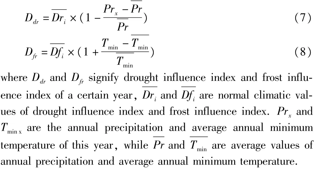
The calculated Dr and Fr values are normal average annual climatic values.To predict climatic yield of sugarcane in a certain yield,we should determine the difference between temperature and precipitation of current year and average annual value.This difference can be described by the anomaly of annual precipitation and average minimum temperature of current year:

3 Prediction results of climatic yield of sugarcane in Nanning City
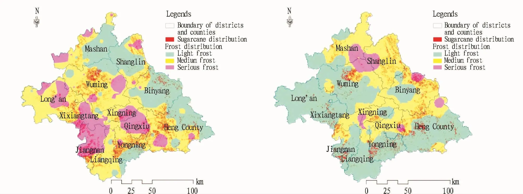
3.1Spatial distribution of sugarcane planting and meteorological disasters The distribution of sugarcanes is not only restricted by meteorological conditions,but also influenced by regional terrain and other non-natural factors.Through superposition analysis on total sugarcane planting area of Nanning City obtained from remote sensing classification and the sugarcane distribution(Table 4)determined by equations(5)and(6),we obtained superposition analysis results of sugarcane distribution and meteorological disasters in annual normal state of climate(Fig.1).From the distribution of entire sugarcane planting areas,it can be known that sugarcane planting of Nanning City is mainly centralized in Binyang County,Wuming County,Heng County,Yongning District and Jiangnan District,while in Shanglin County,Mashan County and Long'an County,there is little sugarcane planting.From the distribution of drought disasters(the left of Fig.1),it can be seen that serious droughts occur mainly in Jiangnan District,Xixiangtang District,Xingning District,Qingxiu District,Long'an County and Heng County.Except Jiangnan District having large area of sugarcane planting,other areas have little sugarcane planting.In regions suffered from serious drought,the total sugarcane planting area is346.20 km2,accounting for18.88%of total sugarcane area;most sugarcane areas of Wuming County,Heng County and Yongning District are situated in medium drought areas,and this level of sugarcane planting area takes up 55.76%of total sugarcane planting area.In Binyang and Shanglin counties,due to sufficient river irrigation and rich rainfall,sugarcane areas are situated in light drought areas and the sugarcane area influenced by light droughts takes up 25.36%of the total sugarcane area.From distribution of frost disaster(the right of Fig.2),it can be seen that most regions of Nanning City are situated to the south of Tropic of Cancer,so the frequency and influence of extreme minimum temperature are local;apart from Daming Mountain area situated in serious frost disaster area due to high elevation and low temperature,some sugarcane areas of Binyang County also suffer from serious frost.In Heng County and Qingxiu District,there are also serious frosts,but they are not main sugarcane planting areas,thus the influence on sugarcane planting is small,only 67.1 km2sugarcane planting area is influenced by serious frost,accounting for3.75%of total sugarcane planting area;most areas of the rest are slightly influenced by light frost disasters.

Fig.1 Drought(left)and frost(right)distribution and sugarcane distribution in Nanning City

Table 4 Distribution of sugarcane planting in Nanning City
3.2Prediction results and verification of climatic yield of sugarcane Substituting sugarcane areas influenced by various meteorological disasters to equation(2)and equation(4),we can obtain the value Di of drought and frost in normal climate is 0.82 and 0.94 respectively.Using average value of the minimum temperature and precipitation in 9 standard meteorological stations of Nanning City,we calculated the anomaly of precipitation and minimum temperature between 2010 and 2006-2010.According to equation(7)and(8),the Di value of drought and frost in 2010 is 0.87 and 0.91 separately.Finally,substituting Di to equation(1),we finally obtained the climatic yield of sugarcane of Nanning City in 2010 was8.8446million tons.In the study ar-ea,we selected sugarcane areas of Nanning Sugar Industry Company and compared the actual yield data in 2010/2011 season with out prediction value,and found that the prediction accuracy is up to 90.2%.This indicates that our prediction model for climatic yield can reach the prediction accuracy above 90%.
4 Conclusions
The prediction model of climatic yield of sugarcane is based on superposition and analysis of spatial distribution of climatic disasters and distribution of sugarcane planting areas.For the sugarcane yield of a certain year,it is feasible to make prediction according to current climatic prediction data provided by the meteorological authority and sugarcane growth vigor.Therefore,it is recommended to properly arrange grinding season according to distribution of rainfall in the same year,to facilitate increasing sugar content in the grinding season.Besides,it should make proper arrangement of sugarcane harvesting and transport works.For areas vulnerable to frost disasters annually,it is proposed to give priority to harvesting and transport,so as to reduce losses due to frost disasters.Finally,sugarcane farmers should make proper adjustment of sugarcane harvesting,transport and grinding season according to actual growth of sugarcane and prediction results of the yield.
[1]CHEN H,LIN TZ.Relationship between seasonal yield of sugacane colony growth and meteorological factors[J].Sugarcane,1994(4):12-15.(in Chinese).
[2]HE Y,TAN ZK,DINGMH,et al.Study on key meteorological factors restricting Guangxi sugarcane yields and sucrose content[J].Journal of Anhui Agricultural Sciences,2008,36(8):3181-3184.(in Chinese).
[3]JIANG JS,XIE GS,LIN LF,et al.Relationship between meteorological factors and sugarcane growth and the establishment of its prediction model[J].Sugarcane,1991(4):1-5.(in Chinese).
[4]OU ZR,TAN ZK,MO XH,etal.Study on the climate condition of sugarcane yield in Guangdong[J].Sugar Crops of China,2008(4):45-47,51.(in Chinese).
[5]SU YX,LIZ,SUN H.Climate division of sugarcane planting based on GIS in Guangxi[J].Chinese Journal of Agrometeorology,2006,27(3):252-255.(in Chinese).
[6]DINGMH,TAN ZK,LIH,et al.Survey methods of sugarcane plant area based on HJ-1 CCD data[J].Chinese Journal of Agrometeorology,2012,33(2):265-270.(in Chinese).
[7]TAN ZK,OU ZR,HE Y.Analysis of the major meteorological calamity and the research on optimum layout of cane sugar production in Guangxi[J].Sugarcane and Canesugar,2006(1):17-21,33.(in Chinese).
 Asian Agricultural Research2014年2期
- Asian Agricultural Research的其它文章
- Training and Recommendations on the Lower Limbs Exp losive Force of Juvenile Amateur M en Sprinters
- Efficiency Evaluation of Vegetable Specialized Cooperatives Based on Data of Chongqing Municipality
- Effects of Soil C/N Ratio on Apple Grow th and Nitrogen Utilization,Residue and Loss
- Drought and Waterlogging Characteristics during the Grow th Period of Summer Maize in Luxi Plain Areas
- Assessment of Cultivation M ethod for Energy Beet Based on LCA Method
- Incentives for the Quality and Safety Traceability System of Agricultural Products
