
Stable Isotope Composition of Rainfall, Surface Water and Groundwater along the Yellow River
2013-11-25 03:03:04YanZhangShuaiSongJingLiFadongLiGuangshuaiZhaoQiangLiu
地下水科学与工程(英文版) 2013年1期
Yan Zhang, Shuai Song, Jing Li, Fadong Li*, Guangshuai Zhao, Qiang Liu
Abstract: The intention of this work is to consider the stable isotopic compositions of oxygen and deuterium in rainfall, surface water and groundwater along the Yellow River in the North China Plain(NCP). This demonstrated that the δ18O values in groundwater varied from -10.17 to -6.85‰, with mean value of -8.76‰, and that the δD ranged from -68.7 to -58.0‰, with mean value of -63.4‰, respectively.The δ18O values in surface water varied from -8.36 to 1.32‰, with mean value of -6.8‰, and δD ranged from -64.4 to -35.1‰, with mean value of -57.6‰, respectively. Further, The range of Cl- values of groundwater varied from 5.9 to 340.5 mg/L and that values ranged from 30.1 to 81.9 mg/L in surface water samples and Na+ value changed from 27.4 to 321 mg/L in groundwater, while that in surface water varied from 24.8 to 50.5 mg/L. Most of the points fall below the GMWL, but are close to the LMWL. Therefore the results indicated that the groundwaters along the Yellow River were influenced by rainfall in heavy events and surface water.
Keywords: isotope; groundwater; North China Plain
Introduction
Knowledge of the stable isotopic composition of oxygen (δ18O) and hydrogen (δD) in atmospheric rainfall is an important tool for water research all over the world in hydrological studies(M. Bar-Matthews et al. 1999). Isotope hydrology is able to provide thisinformation because the spatial variations in the isotopic composition of rainfall are due to isotopic fractionation occurring during the evaporation of seawater and condensation during the advection of water vapour(E. Dotsika et al. 2010).Studies on several areas have established that natural spatial distributions of the δ18O and δD isotopic compositions of rainfall are primarily a function of the fraction of water remaining in the air mass as it moves inland over topographic features (C. Kendall and T. B. Coplen 2001) The δ18O and δD of rainfall are also influenced by temperature, altitude, distance inland along different stormtracks, environmental conditions at the source of the vapour, latitude, and humidity (J. R. Gat 1996). The δ18O and δD of rivers will reflect how the relative amounts of rainfall and groundwater vary with time, and how the isotopic compositions of the sources themselves change over time (C. Kendall and T. B.Coplen 2001).The dual nature of surface water and groundwater can be exploited for studying regional hydrology or climatology (M. G. Sklash et al.1976).Under favourable circumstances, knowledge of the isotopic compositions of the major water sources can be used to quantify the time-varying contributions of these sources to river water. Since many developing cities are located on the plain.There is an annual increase in the amount of water that needs to be pumped, this is concurrent with a decline in the potentiometric surface of the aquifers. Furthermore, ground water is also the source of much of the water used for irrigation (C.Zongyu et al. 2005). Alternatively, if the isotopic composition of base flow is thought to be a good representation of mean annual rainfall, then the δ18O and δD of riverside sampled from irrigation areas are useful for assessing regional patterns in rainfall. Consequently, a number of workers in the North China Plain (NCP) have investigated meteorological processes largely on the basis of samples from small streams and shallow groundwater (J. Chen et al. 2004; Z. Chen et al.2005; Z. Q. Zhang and H. P. Zhang 1987).
As one of Chinese most important social,economic, and agricultural regions, the NCP is facing an increase in water demands associated with rapid population increase, industrial development, and expansion of irrigated land which has led to overexploitation of surface and ground water resources with resultant water-shortage and poor water quality (F. Li et al.2008). Knowledge of the age of the NCP ground water has very important and practical implications for water resources management. The surface water and groundwater along the Yellow River represent important water resource in semi-arid and semi-humid areas in China and worldwide (J. Stimson et al. 2001; S. Foster et al.2004). Impacted by anthropogenic and natural factors, the route of the Yellow River has been changed up to 1,600 times since B.C. 602. In Xinxiang area, the hydrogeochemical characteristics of surface waters and groundwater have been a subject of several recent surveys (G.Pan 2006; XWSO 2000). In NCP hydrogeochemical and isotopic methods have been used to determine the chemical evolution of groundwater, to evaluate its past, current status and future, and to provide understanding for groundwater management (J. Chen et al. 2004; Z.Chen et al. 2005; G. Zhang et al. 2004). However,these works paid more attention to the spatial evolution, interconnection of individual aquifers,and vulnerability of surface water and groundwater from the piedmont, central plains, and littoral plain on a regional scale. Moreover, most of them were carried out in the central region of the NCP rather than along the Yellow River. They did not quantitatively evaluate the isotopic composition of the surface water and groundwater caused by irrigation. The isotopic composition of surface water and groundwater in Yellow Riverside area is determined both by its location within an irrigation area, of the NCP, and by the existence of Yellow River. This study utilizes river water to provide baseline data on the spatial distribution of δ18O and δD of meteoric waters for local hydrologic investigations and regional palaeoclimatic assessments, and it provides the foundation for future, more quantitative, evaluations of the relative contributions of recent rainfall, surface water and groundwater in the rivers.
In this study, we present the stable isotope composition of surface and groundwater along the Yellow River, aiming to describe stable isotope(δ18O and δD) composition of surface water and groundwater, evaluate its relationship to the isotopic composition of rainfall.
Background
The NCP is located in the eastern part of China between 36° and 40°N and between 114° and 118°E (Fig.1). The NCP is an important region of agriculture in China, with an area of about 13,600 km2and a population of around 112 million (J.Chen et al. 2004). Bounded by Taihang Mountain to the west, Yanshan Mountain to the north, the Bohai Sea to the east, and the Yellow River to the south, the plain is a fault subsidence basin with Quaternary sediment about 400-600 m thick. The River system include the Yellow River and the Haihe River and its main tributaries. Before B.C.602, the Yellow River flowed toward the northeast along the east of Taihang Mt. across the south of Xinxiang, east of Anyang, west of Hengshui, and then converged with Haihe River. The shallow groundwater table declined significantly, at a mean rate of approximately 1 m/year in this area over the past several decades, and the area of the groundwater cone of depression has expanded in Xinxiang in the NCP (Y. Yang et al. 2004). From 1974 to 2005, the water table in Xinxiang declined by 6 to 18 m with a depression cone area of 40 km2,associated with severe groundwater pollution (G.Pan 2006). Study area contains Fengqiu County,Wen County, Wuzhi County, Yuanyang County,Changyuan County, Zhengzhou City, Kaifeng City,Jiaozuo City, Boai County, Xiuwu County,Qinyang City, Hebi City, Xinxiang County, etc. A general overview of the study site showing the geology and the sampling locations is presented in Fig. 1.
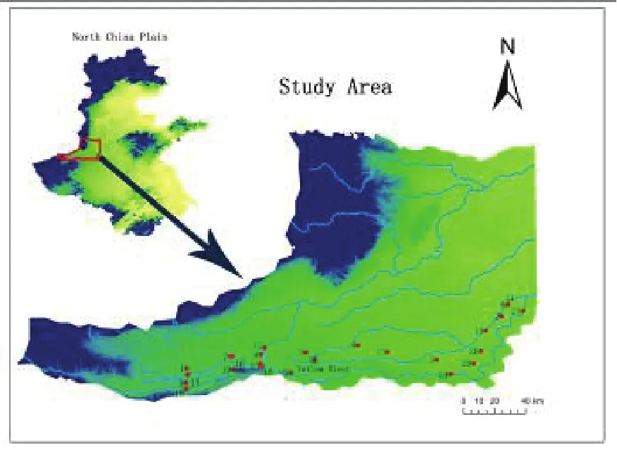
Fig.1 Location of the sample sites
Methods
To analyse the spatial variation of stable isotopes composition, 9 surface water samples and 17 groundwater samples were collected from private, factory, and observation wells of locations along the Yellow River in July 2007. The sampling was carried out during irrigation periods. All the water samples were collected using high-density HDPE bottles for isotopic analyses. Thirteen rainfall samples were taken for isotope analysis after storm events from July to September 2007.
The isotopic compositions of oxygen (18O) and deuterium (2H or D) in groundwater and surface water were examined by the Isotope Ratio Mass Spectrometer (Finnigan MAT-253) with TC/EA method at Institute of Geographic Sciences and Natural Resources Research laboratories, Chinese Academic of Science. The results of18O and D were expressed in per mil unit as d-notation relative to Vienna Standard Mean Ocean Water(VSMOW) standard, as shown in Eq. 1. The δ18O and δD measurements were reproducible to ±0.2‰and ±1.0‰, respectively.
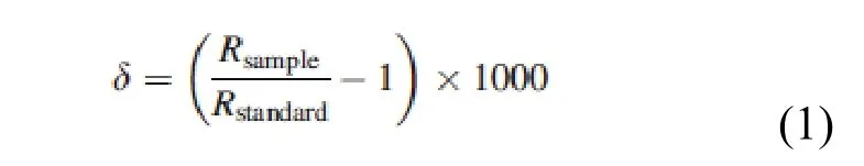
Where, Rsampleand Rstandardwere the measured isotopic ratio for sample and for standard,respectively.
EC and pH were measured by portable pH and EC meter (Compact meter, Horiba, Japan) in situ and verified in the laboratory using higher precision meter (D23, Horiba, Japan). All samples were filtered through 0.45 m cellulose acetate filter membrane before using ion chromatograph (Shimadzu, Japan) to analyze Cland Na+. The chemical results were only accepted when the charge balance error was within ±5%.
Results and discussion
Characters of δ18O, δD, pH, EC and Na/Cl
Table 1 shows the values of δ18O, δD, EC and pH for surface water and groundwater samples in the study area. pH in rainfall (6.62-7.45) is lower than both in surface water and in groundwater. All surface water samples were relatively similar in pH values (7.36-7.74), but slightly lower than those of groundwater sample (7.74-8.06) (Table 1). Mean value of EC in groundwater and surface water was 1195.33 and 742.73 S/cm, respectively. Low EC values in surface water were found in the Yellow River, whereas the groundwaters had higher EC because of lixiviation.
Stable isotopes (δ18O and δD) can provide useful information on the sources of water. δD values in rainfall varied from -78.5 to -58‰ with mean value of -65.7‰, and δ18O ranged from-9.19 to -4.49‰ with mean value of -7.38‰,respectively. δ18O values in groundwater varied from -10.17 (no. 14 in Wen country) to -6.85‰(no. 1 in Wen country ) with mean value of-8.76‰, and δD ranged from -68.7 (no. 7 in Wuzhi country) to -58.0‰ (no. 4 in Yuanyang country) with mean value of -63.4‰, respectively.δ18O values in surface water varied from -8.36 to 1.32‰ with mean value of -6.8‰, and δD ranged from -64.4 to -35.1‰ with mean value of -57.6‰,respectively. A few samples are enriched in δD(i.e., no.22, no 17, no.18 and no.21) in this study.Chemical processes, such as methanogenesis and sulfate reduction, can cause δD values to move up from the local meteoric water line without corresponding shifts in δ18O values. The δD values were enriched because those samples probably were related to methanogenesis (Z. Chen et al.2005).
Much of the deep confined groundwater in the NCP is probably thousands of years old. This paleo-groundwater is often characterized by depleted δ18O and δD with respect to modern recharge because it was recharged during a colder climate in the Pleistocene (Z. Chen et al. 2005).The values of both δD and δ18O from surface water to groundwater decrease by ~11.1‰ and 1.96‰, respectively.

Table 1 Stable isotope results of surface water and groundwater samples

Note: GW- groundwater; SW- surface water; R- Rainfall.

Fig. 2 Relationship between Na+ and Cl- for groundwater and surface water
The range of Cl-values of groundwater varied from 5.9 to 340.5 mg/L and that values ranged from 30.1 to 81.9 mg/L in surface water samples.Na+value changed from 27.4 to 321mg/L in groundwater, while that in surface water varied from 24.8 to 50.5 mg/L (Fig.2). Surface water of the Yellow River is featured by low ion molar ratio of sodium to chloride, whilst groundwater ratio of sodium to chloride is 0.7. The regression equation of groundwater shows that ratio of groundwater is larger than surface water, which indicated the ion exchanges between Ca and Na in the groundwater.
Relationship of δ18O and δD
The relationship of δ18O and δD composition of meteoric waters varied in a range that was close to the global meteoric water line (GMWL), termed as δD=8δ18O+10[17]., The relationship between δ18O and δD composition of rainfall is different from one region to the other and is dependant on the local climatic conditions (J. Hoefs 2009). δ18O and δD of rainfall data cited from the Global Network for Isotopes in rainfall dataset(IAEA/WMO 2004) were used as Local Meteoric Water Line (LMWL, δD=6.75δ18O - 3) shown in Fig. 3. LMWL data are calculated by monthly accumulated rainfall on Zhengzhou City from September 1985 to December 1992. Fig. 3 indicated that some isotopic data points fall close to the GMWL and most of the points fall below the GMWL, This usually suggests the effects of evaporation from different areas. A comparison of the ratio of δ18O and δD compositions with LMWL,indicates most points are close to the LMWL.
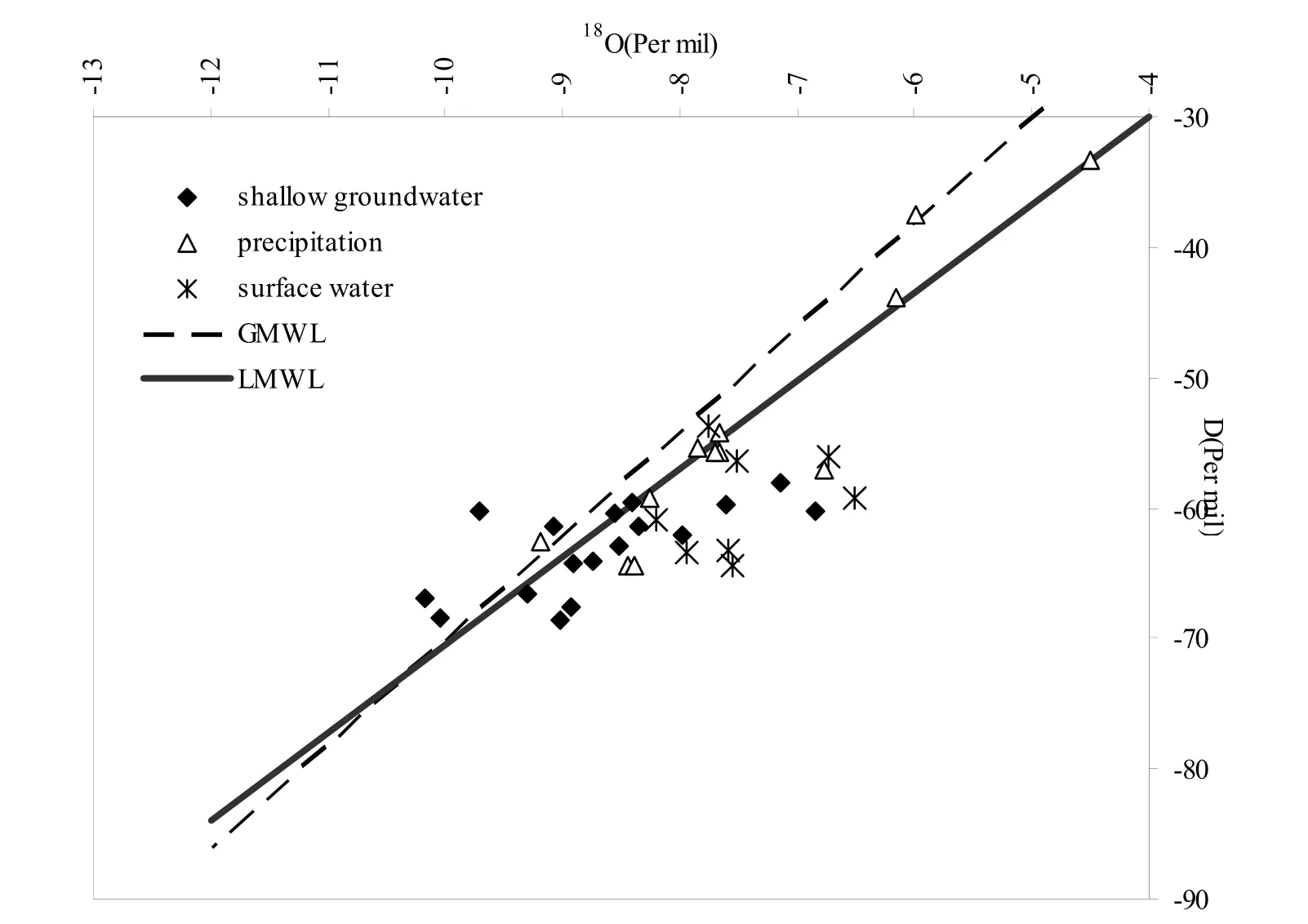
Fig.3 δ18O-δD plot of all groundwater and rainfall samples
The relationship between δ18O and δD of surface and groundwater in this area is also shown in Fig. 3. The majority of surface waters from the Yellow River fall below the LMWL, indicating the effect of evaporation. However, the isotopic composition of groundwater samples along the Yellow River close to the surface water indicate that the groundwater sources of the are affected by the seepage of the Yellow River, especially during the irrigation season. The majority of groundwater also falls below the LMWL, with average δ18O and δD of -8.7‰ and -63.1‰. The averaged values of δ18O and δD of shallow groundwater are significantly lower than the average values of the δ18O and δD of rainfall in this area. The low δ18O and δD values of the shallow groundwaters implies that they accepted the recharge from the rainfall with depleted stable isotopes in heavy rainfall events. The other groundwater samples which were close to the LMWL indicate the recharge sources derived from modern meteoric water.
Conclusions
Based on stable isotopic data of rainfall,surface water, and groundwater along the Yellow River, the main features observed in this study are:(1) δ18O values in groundwater ranged between-10.17 and -6.85‰, while that in surface water ranged between-8.36 and 1.32‰; (2) δ18O values in surface water varied from -68.7 to -58.0‰,while that in surface water varied from-64.4 to-35.1‰; (3) the values of both δD and δ18O from surface water to groundwater decrease by ~11.1‰and 1.96‰, respectively; (4) the range of Clvalues of groundwater varied from 5.9 to 340.5 mg/L and that values ranged from 30.1 to 81.9 mg/L in surface water samples. Na+values changed from 27.4 to 321 mg/L in groundwater,while that in surface water varied from 24.8 to 50.5 mg/L, (5) most isotopic data points both in surface water and groundwater fall below the GMWL, and are close to the LMWL. (6) The averaged values ofδ18O and δD of shallow groundwater are significantly lower than the average values of δ18O and δD of rainfall in this area.
- 地下水科学与工程(英文版)的其它文章
- Source and Formation of the Arsenic in Ground Water in Hanoi , Vietnam
- Study on Ecological Environment and Sustainable Land Use Based on Satellite Remote Sensing
- Organic Contamination of Soil and Goundwater in the Piedimont Plain of the Taihang Mountains
- Comparison of Three Brine Migration Models in Groudwater
- Effect of Farmyard Manure Application on Dissolution of Carbonate Rocks and Its Eco-environmental Impact
- Groundwater quality Management in China