鞠躬桥和滨水公园,成都,中国
2011-07-30 12:37:56MICHAEL,MALTZAN,ARCHITECTURE
世界建筑 2011年12期
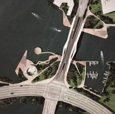
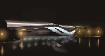
1 鸟瞰透视/Rendering, aerial view
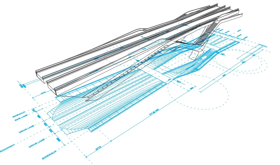
2 平面轴测图/Plan axonometric
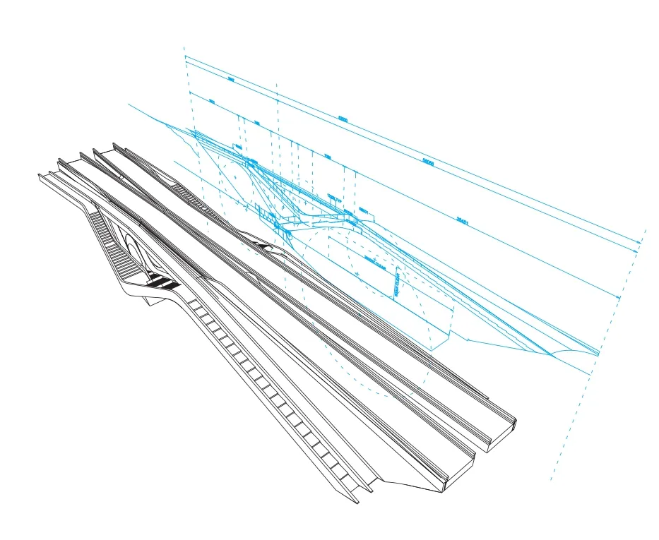
3 剖面轴测图/Section axonometric
豪美河小区新建于中国发展迅速的四川省,面积228.6hm2,鞠躬桥与滨水公园构成了该小区的一个重要纽带。小区内湖河交错,新居住社区位于中心,形成小区的特征与整体结构。桥与公园作为标志性建筑,将建筑、结构与景观无缝连接。
综合建筑与运动
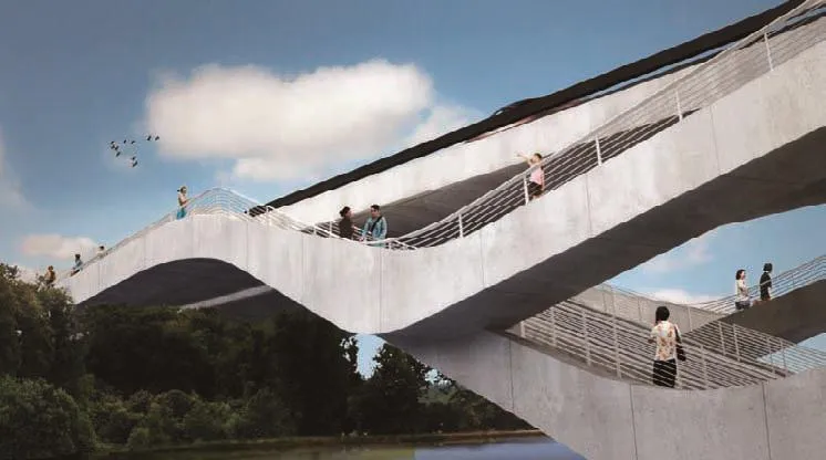
桥跨79m,包括双向车行道以及多条人行和自行车道,连接小区的住宅区与商业中心。各条道路在桥末端与滨水公园交汇,将桥梁与风景以及湖岸道路网络相连接。桥在中心下弯与水面相接,同时支持上面的结构并形成与下面河道的关键连接。
体验倒影
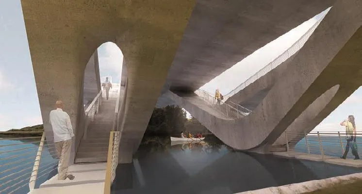
桥不仅仅用来连接两岸,其中部加宽,构成了更加亲密的空间供人聚会和休憩。采用复古的“美人靠”座椅,为赏水的看客提供片刻静谧小憩。人行巷道向下延伸至道路下方中部桥墩,锥形造型轻拂水面。双桥墩包含人行通道,从毗邻岸边攀升至桥中心,然后分开形成桥孔,区隔桥体结构与上方天空。夜晚,LED光带标识出这个弧形通路。
城市网络
内部交错的交通道路延伸至毗邻的滨水公园,连接桥梁、附近的散步道、咖啡厅以及新表演馆。人行道在水边蜿蜒,终点位于桥西侧的音乐圆亭。音乐圆亭的曲面造型超越公园高度,成为桥以及远处湖岸的新制高点。柳树直廊从圆亭向下延伸,与河相接,和树冠下蜿蜒曲径相映成趣。□
The Ju Gong Bridge and Waterfront Park form a vital link within the new 565-acre Luxe Lakes development in China's rapidly growing Sichuan Province. The new community is located at the center of an extensive network of lakes and rivers that define the identity and overall organization of the development. The Bridge and Park are iconic infrastructure features that seamlessly integrate architecture, structure and landscape.
Synthesizing Structure & Movement
Linking the development's residential areas and commercial center, the 260-foot span incorporates two-way vehicular traffic and multiple pedestrian and bicycle pathways. These routes connect to the waterfront park areas at the bridge's endpoints,linking the bridge with the landscape and an extensive network of waterfront routes. The bridge bows at its center to meet the water's surface,simultaneously supporting the structure above and creating a key connection to the river below.
An Experience of Ref ection
The bridge is more than a simple connection between one bank and another. At its center, the bridge widens to incorporate a more intimate space for gathering and rest. By incorporating seating which recalls the traditional mei ren kao,or “beautiful seat,” the bridge provides a moment of idyllic repose visitors with views looking out over the water. As the pathway descends to the central pier beneath the roadway, its tapered form grazes the water's surface. These twin piers incorporate pedestrian paths that climb from the adjacent bank to the bridge's center, parting to form an aperture framing the structure and sky above. At night, LED light ribbons trace these arched pathways.
An Urban Network
The interwoven traffic lanes extend to the adjacent waterfront park, linking the bridge,nearby marina, cafe and new performance pavilion.Pedestrian pathways curve along the water's edge, culminating at a circular pavilion for music immediately west of the bridge. This pavilion's curvilinear form rises above the park to create a new vantage point of the bridge and waterfront in the distance. Straight allees of willows descend from the pavilion to meet the river, creating a counterpoint to the meandering circulation paths beneath their canopy. □
4 夜景透视/Rendering, night view
5 从下部看透视/Rendering, from below
6 细部透视/Rendering, detail
类型/Type: 公共滨水公园,双车行和行人桥梁,码头和咖啡馆/Public waterfront park with two lane automobile and pedestrian bridge, marina, and café
面积/Size: 0.4hm2,跨度79m/1 Acre, 260’ span
造价/Cost: 客户要求保密/Withheld at client's request
状态/Status:将在2012年完成/To be completed 2012
猜你喜欢
房地产导刊(2020年9期)2020-10-28 08:37:24
山东交通科技(2020年1期)2020-07-24 08:28:46
上海公路(2018年1期)2018-06-26 08:37:36
知识经济·中国直销(2018年4期)2018-04-18 12:04:30
浙江工业大学学报(2017年5期)2018-01-22 02:03:36
现代园艺(2017年22期)2018-01-19 05:07:10
水利规划与设计(2017年8期)2017-12-20 08:23:58
工业设计(2016年11期)2016-04-16 02:45:51
设备管理与维修(2016年6期)2016-03-16 02:21:58
工程建设与设计(2016年8期)2016-03-11 15:57:34