
Identification of Dredgers in Changjiang River Using ASAR Images
2010-09-05 12:44CHENGXuejunWANYouchuanCAOBoSchoolofRemoteSensingandInformationEngineeringWuhanUniversityWuhan43007ChinaYangtzeRiverScientificResearchInstituteWuhan43000China
长江科学院院报 2010年1期
CHENG Xue-jun,WAN You-chuan,CAO Bo(.School of Remote Sensing and Information Engineering,Wuhan University,Wuhan 43007,China;.Yangtze River Scientific Research Institute,Wuhan 43000,China)
Identification of Dredgers in Changjiang River Using ASAR Images
CHENG Xue-jun1,2,WAN You-chuan1,CAO Bo2
(1.School of Remote Sensing and Information Engineering,Wuhan University,Wuhan 430072,China;2.Yangtze River Scientific Research Institute,Wuhan 430010,China)
This paper explores a key technique of identifying and locating the sand exploitation ships using ASAR(advanced synthetic aperture radar)images.Chenglingjiof Changjiang Riverwas selected as the research region.One softwaremodule is developed with the IDL(interactive data language)which is a facingmatrix,simple visual language.And the paper re-searches some key techniques based on ASAR images,such as filtration and noise reduction,the processing of image based onmorphology,boundary detection,region growth,extraction of ship’s shape feature and so on.In comparison with the field monitored results,thismethod can achieve 80%-90%accuracy.
ASAR;feature extraction;sand dredge;remote sensing;identification
1 INTRODUCTION
There is tremendous sand resource in Yangtze River which is one of the very important buildingmate-rials.In recent years,illegal sand excavation in Yan-gtze River becomesmore and more serious.It brings a potential risk to dike security and a tremendous eco-nomic loss to our country.The illegal sand exploiting criminals usually occur at night and the dredgers often change the exploitation place to escape law-enforce-ment and supervision.To adapt the new situation,new monitoring techniques and means must be adopted in order to enhance rapid response ability,expand the coverage of monitoring,as well as realize all-weather monitoring[1].The ASAR images have a short revisit period and have many advantages including covering large area and ignoring the effects of all-weather condi-tion.It is appropriate to enhance supervision as a sup-plementary mean of traditional law enforcement.
Boarded on the ENVISAT21 satellite,the ASAR is a most advanced space-borne synthetic aperture ra-dar image system,working in C-band,with active phased array antenna system,five kinds of imaging modes,seven kinds of imaging stripes and alternating polarization imaging function.It has some special char-acters such as multi-mode,multi-polarization and a significant width,multi-incident angle etc.According to echo strength,the goal can be divided into strong and weak reflective targets.Strong reflective targets such as bridges,ships,airports,and oil depots can be detected easily.Water body is weak reflective target which has a strong microwave absorption capacity and forms specular reflection tomicrowave[2].So the water body appears black in ASAR images because of weak back-scattering.Ships in the water have strong forward scattering capability.If an appropriate threshold is se-lected,ships can be separated easily from water re-gion.Based on different scattering characteristic be-tween water and ship,ASAR images can be used to i-dentify ships,especially large sand exploitation ships.
2 STUDY REGION AND IMAGE PROCESSING
2.1 Study region
Chenglingji reach of Yangtze River is selected as a study region in this paper.Chenglingji reach,which islocated at the junction of Hunan and Hubei provinces,is the mouth of Dongting Lake to Changjiang River.And its flood control situation is very serious.The phe-nomenon of illegal sand exploiting is prominent and threats to the levee security of Changjiang River.The studied ASAR images,which cover Chenglingji reach,were taken on April1,2007.Fig.1 shows the study re-gion.

Fig.1 Main interface
2.2 Image processing
In this paper,both image processing and corre-sponding feature extraction of the sand exploiting ships are developed by IDL language.As a simple grammar fourth generation visual language for the matrix,IDL can commit to conduct scientific data visualization and analysis,it is the best choice for image processing.Because it combines visualization,interactive analysis and development,it can meet the demand of sand ex-ploiting ships very well.Themain interface of software module is shown as Fig.1.
The ASAR data is processed by noise reduction,the statistical analysis uses a histogram.Then an ap-propriate threshold is used to separate water area and non-water area.Through the cluster processing,clear border information of the suspicious area can be got by using boundary detection technology.It is easy to con-duct statistics on the target’s length,width,area and other shape information,and calculate the regular pa-rameters.After determinating the objectives of suspec-ted large-scale sand exploiting ships,the further pro-cessing ofmorphology is to be carried on[3].Dredgers always have a tall and thin tower as a special construc-tion characteristic.However,this characteristic is not clear in ASAR images because the ASAR image resolu-tion is not high enough.And sometimes the thin tower seems not connected with the ship from the images.Meanwhile,the filter not only reduces noise,but also damages some useful frail boundary information.Tech-niques ofmorphology,such as erosion and dilatation,are used to solve this problem.The algorithms of ero-sion and dilatation can not only reduce noise,but also connect narrow part and fill holes.Finally,in combi-nation with GIS technique,relative information is ac-quired to quicken classification.All information inclu-ding forbidden exploitation sections,e.g.artificial ob-jects or islands in river and so on,altogether assist to identify dredgers.Fig.2 shows the process of target ex-traction.

Fig.2 The process of target extraction
3 EXTRACTING METHOD
After noise reduction,it can be found from ASAR images that water body is bleak and ships are bright.There is a typical bimodal pattern histogram and larger spacing peaks are on the image histogram.The pattern shows that the features have distinct comparison which shows with great values varying in gray.Many tests have been done to select an appropriate threshold to analyze the gray distribution ofwater bodies and ships.For example,the firstwave peak may be regarded as a typical gray value of water body,and by analyzing the waveform,the deviation valueΔλcan be got.The pix-els,whose gray value between±Δλis a typical gray value,are regarded as water bodies.Using the samemethod,the second wave peak is regarded as non-wa-ter feature typical gray value and prepared for cluste-ring processing[4].
3.1 Cluster
The shape parameters of target features such as perimeter and area are difficult to measure by eyes.However,accurate statistics of these parameters are the keys to shape parameter.The principle of regional growth is adapted to acquire precise region boundary and area.The basic idea of region growth is to have similar gray nature pixels together to constitute a re-gion.And this region can be seen as a feature.First of all,each partition of the region needs to find a seed pixel as start point of growth,then the seed pixel neighborhood whose gray is same or similar(the rule of same or similar pixels is defined before growing)is combined into seed pixel’s area and become new seed area.This process will continue until no more pixels satisfy the rule,and the region growth completes.This article has adopted two kinds of growth strategy,i.e.point-source and non-point source growth.The test re-sults show that the two kinds of growth strategy can meet the needs of cluster.
(1)The point source growth strategy selects the typical characteristic point as the seed(Fig.3(b)shows growing results of the water body).And the non-point growth strategy selects a certain region as the seed(Fig.3(c)shows growing results ofwater body).
(2)The pixel growing rule can be four neighbor-hoods or eight neighborhoods.
(3)The stopping condition of the point growth is that the gray value of the neighborhood exceeds±Δλ to water body typical gray value.The stopping condi-tion of the non-pointgrowth is that the gray value of the neighborhood exceeds standard deviation or gray value range of the seed area.
After a regional growth obtains some important re-gion factors such as area and perimeter,themaximum gray value,minimum gray value,mean and standard deviation and so on can be calculated precisely accord-ing to the number and distribution of the pixels in the new growth area.So it can greatly improve the auto-matic statistics of the target shape information such as length,width,area etc.,therefore regular parameter can be calculated from these statistics.

Fig.3 The results of water clustering based on two strategies
3.2 Regular Parameter
The definition of regular parameter is

where B is the region perimeter and A is area.To some extent the regular parameter is a compact index.It is dimensionless,and insensitive to the scale and rota-tion.It does not have a fixed range.The greater the value,the less the compact and regular shape.A rea-sonable choice of parameters can remove suspected ships whose regular parameters are different from dredgers.If a suitable F range is selected according to field survey experience and characteristics of sand dredging,it can be used as an index of shape to filter suspected region[5].
3.3 Erosion and Dilation
It is difficult to distinguish dredgers from large-scale transport ships only based on regular parameters and shape information because dredgers can be regard as special transport ships.Uniquemorphological char-acteristics of the sand dredging are needed.Field sur-vey results show thatevery dredges has a high tower for absorbing sand,which appears aГshape on images.However,noise reductionmakes images inevitably lose a part of useful information which will cause the fea-ture’s contour to be not clear.Therefore,it is necessa-ry to use erosion and dilation to refine image contours for extracting featuresmorphological characteristics ac-curately.
Mathematicalmorphology is amathematical image analysis tool based on shape.It is a non-linear filtering method for collection process.As the basis ofmathe-maticalmorphology,erosion and dilation are used to solve the feature extraction,edge detection and image segmentation problem of the binary image.Inmorphol-ogy,the structural element is the most important and basic conceptwhich is equivalent to"filter window"in signal processing.If A and B are two collections,cor-rosion and expansion can be defined as:

Where:B is the structured element;A represents the input image;AΘB indicates x points collection in-cluding in the A after shifting B wit x pixels;AB de-notes the x points collection after shifting B wit x pix-els,and the intersection point collection of B and A is not empty.As the basis for image processing,the structural elements’size and shape which are chosen appropriately or notwill impact on the results of image morphological operations directly.Hence,it is needed to choose appropriate structural elements for different applications[6].
In correspondence with the actual results of image processing,the erosion usually reduces the target size which can eliminate glitches and reduce noise.Dilation usually increases the target sizewhich can fill hole and disconnect regions.
4 APPLICATION RESULTS AND ANALYSIS
The statistics of length,width,area,perimeter and other parameters are done in the having ships’area by region growthmethod.In Figure4,five area’s aspect ratios of ship and regular parameters are calculated(Other ships are unlikely large-scale dredgers whose surface area are very small).Table 1 shows the results.
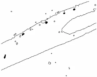
Fig.4 Ships in experiment

Table 1 Shape characteristics parameter
According to field survey on a large number of sand dredgers,the statistics shows the dredger’s shape parameters range.In comparison to the range,the ship No.1 and No.2 are confirmed as focused objectswhose dredger’sГshape is extracted usingmorphological pro-cessing.
From the circle region in Figure 5(a),it is shown that the region is regular long.Moreover,all factors,like length,width,area,perimeter and regular param-eters,match the dredgers standard.However,the in-formation is not enough,and more information are nee-ded through further processing and mining.In contrast with surrounding,environmentweakens the thin build-ings on board.In addition the human’s eyes are sensi-tive to color but not sensitive to changes in gray de-gree.So we can’t distinguish the structure details by eyes and ignore a lotof important information.After bi-nary according to histogram threshold,a tall building can be seen on one end of the ship in the circle region in Figure 5(b).The existence of a large number of noises in radar imagesmakes the results not satisfactory and needs further optimization.
After filtering and noise reduction,the image noise has been greatly restrained in Figure 5(c).However,some useful boundary information is lost and the buildings on the ship are undermined while the im-age is smoothed.Therefore,in order to supply ship characteristic shape information while noise reduction,morphological processing should be used.

Fig.5 Com parison of processing effect
The closing operation can reduce noise and retain the boundary information.Figure 5(d)shows the im-age after closing operation.From the image No.1 ship can be asserted as a dredger.And the field survey can also prove the assertion.But this method also makes ship No.2 connect with river shore wrongly.For the ships near bank,the traditional filtering processing works more effectively than the closing operation.Therefore,themethod should be used based on the re-search purpose[7].
5 CONCLUSIONS
An ASAR image processing strategy is developed in this article from the histogram analysis to threshold extraction and clustering,which includes noise reduc-tion,image morphology processing(including erosion and dilation),edge detection and region growth etc.From the test resultswe can see that images are divided into water body and holes(suspected ship region)comparatively successfully.Almostnoises in radar ima-ges are restrained effectively.Through region growth the statistics of the suspected ship’s shape parameter(including regular parameter and aspect ratio)is pre-cise while we retain the ship’s shape characteristics.
In recent years,to take its advantages of mac-rodomain,objectiveness,rapidity,dynamic,economy etc,remote sensing technology brings new vitality for the water conservancy cause and traditional water sci-entific research[8].It has played an important role in the water sector.On the basis of the study results,if the method improves more rapidly and effectively,it will provide powerful support for sand mining monito- ring.Itwill allow full play to sand miningmanagement departments in their administrative function and pro-mote the scientific decision-making upon information.
REFERENCES:
[1] DAIChang-da,JIANG Xiao-guang,TANG Lin-li.Remote Sensing Image Application Processing and Analysis[M].Beijing:Tsinghua University Press,2004.
[2] HEHui,PENGWang-lu,YU Xian-chuan,etal.Compre-hensive ASAR target bridge detection based on combined wavelet transformation and mathematical morphology[J].Computer Aided Engineering,2006,15(3):98-101.
[3] CHEN Ai-jun,LI Jin-zong.Automatic recognition method for quasi-circular oil depots in satellite remote sensing ima-ges[J].Opto-Electronic Engineering,2006,33(9):96-100.
[4] XU Gang-feng,WANG Ping,SHEN Zhen-kang.Recogni-tion ofmain-runway ofairportbased on skeleton[J].Infra-red and Laser Engineering,2006,35(6):717-721.
[5] PASTINAA D,LOMBARDOA P,FARINAB A,et al.Su-per-resolution of polarimetric SAR images of ship targets[J].Signal Processing,2003,83:1737-1748.
[6] DANIEL H,SIMON C R,RICHARD B.Target detection in SAR imagery by genetic programming[J].Advances in Engineering Software,1999,30:303-311.
[7] WANG Min,LUO Jian-cheng,MING Dong-ping.Extract ship targets from high spatial resolution remote sensed im-agery with shape feature[J].Geomatics and Information Science ofWuhan University,2005,30(8):685-688.
[8] FENG Rice,TRISTROM Cooke,DANNY Gibbins.Model based ISAR ship classification[J].Digital Signal Process-ing,2006,16: 628-637.
(Edited by LIU Yun-fei,YIXin-hua)
基于ASAR数据的采砂船只识别定位研究
程学军1,2,万幼川1,曹 波2
(1.武汉大学遥感信息工程学院,武汉 430072;2.长江科学院空间信息技术应用研究所,武汉 430010)
基于空间信息技术,选择长江城陵矶河段典型河道作为试验区域,探索基于ASAR的雷达卫星数据对长江河道采砂船只进行辨识与定位的关键技术。本项目的程序采用面向矩阵、语法简单的第四代可视化语言IDL(inter-active data language)交互式数据语言编制完成。项目中涉及了滤波去噪研究、图像形态学处理、边界检测、区域生长原理、船体形态特征提取等基于ASAR图像的主要关键技术研究。通过与陆面监测站点的实测监测结果相比较,辨识准确率较高。
ASAR;辨识;IDL;特征提取
P228 Document code:A
1001-5485(2010)01-0062-05
date:2009-06-10
CHENG Xue-jun(1975-),male,senior engineer,doctoral candidate.Hismain interests are involved in“3S”techniques ap-plication in water resourcemanagement.(Tel.)027-82826895(E-mail)frank7510@163.com
猜你喜欢
今日农业(2021年8期)2021-11-28
今日农业(2021年13期)2021-11-26
现代畜牧科技(2021年3期)2021-07-21
落叶果树(2021年6期)2021-02-12
电子制作(2018年19期)2018-11-14
自动化学报(2017年11期)2017-04-04
噪声与振动控制(2015年4期)2015-01-01
中国水利(2012年10期)2012-08-15
资源导刊(2010年9期)2010-08-15
轴承(2010年2期)2010-07-28
