The Research of 3D Intelligent Guidance System for the Underground Space
The Research of 3D Intelligent Guidance System for the Underground Space
ABSTRACT
This paper demonstrates a 3D intelligent system of urban underground space guidance.One critical problem of existing guidance systems for the underground space is that they mostly deal with two-dimensional images.Moreover,current systems are also not very intuitionist and thus bring troubles in understanding.On the other hand,the functions of current systems are insufficient,e.g.inconvenient for underprivileged group.In this paper,we design a novel underground space guidance system that can provide helpful information to guide people to travel in the underground intelligently and conveniently.The system can be easily deployed in underground space.Different from most previous systems,it adopts Three-dimensional(3D)simulation technology that cooperates with dynamic display technology,integrating of GPS,GIS,RS computing technology and communication networks.Through this approach,users can find and be guided to their destination quickly.Meanwhile,the system can also offer assistant functions,such as the potential to assist the mobility of the disabled with the application-embedded Voice and Touch prompt functions,internet accessibility etc.The results of simulation show this guidance system is not only feasible but also have effective performance.
KEY WORDS
3D Intelligent Guidance System;3S(GPS,GIS,RS)Dikjstra-algorithm;3D Viewpoint;Communication Networks;Underground Space
[Chinese Library Classfication]TU921;TP391.9 [Documeut Code]A [Article ID]1674-7461(2010)04-0026-08
INTRODUCTION
Owing to the development of the cubic construction of the modern cities the functions of underground space have become important in many cities.With the growth of population,the use of underground spaces has been increased.Especially the subway construction will increase the total scale of underground space development(Liguo et al.,1991).
In our daily life,there are many systems whith give us navigation.One is the car navigation system,which hascommon application in finding one's way in an unfamiliar public place.An automotive navigation system is a satellite navigation system designed for use in automobiles.It typically uses a GPS navigation device to acquire position data to locate the user on a road in the unit's map database.Using the road database,the unit can give directions to other locations along roads also in its database.Dead reckoning using distance data from sensors attached to the drivetrain,a gyroscope and an accelerometer can be used for greater reliability,as GPS signal loss and/or multipath can occur due to urban canyons or tunnels(James R.Akerman,2006;Nakayama,O,1989;Nowakowski;2003;Kim,2002).The other is pedestrian navigation system,such as uNavi(Bessho et al.,2008b),which assists users to freely navigate both indoor and outdoor along with the road map.uNavi utilizes landmark-based guidance by showing still photograph and text information of each landmark in addition to the traditional map based guidance.There are always limited numbers of available photographs in real situation.
Unlike the above system,the key issue of existing guidance systems of underground space is that they mostly deal with two-dimensional images and most current systems are confined to the underground without considering the situation on the ground.The current systems have troubles being understood due to lack of intuitionism On the other hand,the functions of current system are insufficient,e.g.incompatible for underprivileged group.To solve this problem,we have proposed to design a novel underground space guidance system-Three-Dimensional Guidance System(3DGS)that will provide helpful information to guide people travel in the underground intelligently and conveniently.The system can be easily deployed in underground space.Different from most previous systems,it adopts 3D simulation technology that cooperates with dynamic display technology.People can choose the hot points in 3D interface via the touch screen;It can enable users to search intuitively by specify key words and provide users many routes with the time duration,including the optimum one.Through this approach,users can find out the destination and be guided quickly.Meanwhile,the system can also offer assistant functions,such as the potential to assist the mobility of the disabled with the application-embedded Voice and Touch prompt functions,internet accessibility etc.
We will deploy our system in several underground sites.There are many valuable works about the navigation capability and they are already used as a tour guiding service in many countries.In this paper,we focus on its deployment on underground space guidance.This system provides all the space navigation including ground and underground interfaces using text,audio and 3D images in additional to the traditional map based guidance.In addition,the system also provides several advances for the disabled.
The remaining part of this paper is structured as follows.We outline the framework for our guidance system in Section 2.Then,its implementation is described in Section 3.Based on the simulation through 3D virtual technology,the feasibility and effectiveness of result is discussed in Section 4.The last section is the conclusion.
1 THREE-DIMENSIONAL GUIDANCE SYSTEM
1.1Overview
The Global Positioning System(GPS)is a space-based global navigation satellite system that provides reliable location and time information in all weather and at all times and anywhere on or near the Earth when and where there is an unobstructed line of sight to four or more GPS satellites.It is maintained by the United States government and is freely accessible by anyone with a GPS receiver(Agnew,2007;Massatt,2002;Michael Russell Rip,2002).Because of the limitation of GPS veracity for underground space,the 3DGS requires more precise services for the common public facilities underground space.There is no single technology that can offer and overcome the accuracy problem.Besides using GPS,GIS technology also has been used in guidance system.Geographic information systems(GIS)or geospatial information systems are sets of tools that captures,stores,analyzes,manages,andpresents data that are linked to location(s).In the simplest terms,GIS is the merging of cartography,statistical analysis,and database technology.GIS systems are used in cartography,remote sensing,land surveying,public utility management,natural resource management,photogrammetry,geography,urban planning,emergency management,navigation,aerial video,and localized search engines(Chang.1989 and 2008;Clarke,1986;Michael,2010).In addition,some other technologies also have been proposed,such as RFIDs(Liu et al.,2006),the multiple space-identifying devices(Bessho et al.,2008a,Bessho et al.,2007)are some of them.Radio-frequency identification(RFID)is the use of an object(typically referred to as an RFID tag)applied to or incorporated into a product,animal,or person for the purpose of identification and tracking using radio waves.Some tags can be read from several meters away and beyond the line of sight of the reader.On the other hand,the multiple space-identifying approach integrates ubiquitously-deployed multiple space-identifying devices including active and passive RFIDs,and infrared beacons to realize accurate navigation.The main advantage of this approach is the abstraction of space-identifying devices provided by the unique identifier framework,which realizes flexible and extensible device integration.
The 3DGS based on a large amount of data,and the main one is the real world data including timetable data,road network data,subway data,transportation information and the other is on location information data.GPS,Indoor GIS location service help to associate precise information service to the underground space.In this infrastructure,each place is assigned as its own unique coordinate identifier and is attached with device transmitting the identifier.Figure1 is The space information dynamic service system model.Associated with these data,the system can automatically analyze on the basis of Dijstra-algorithm and display the appropriate guidance for users from the underground space to destination.The interface of 3DGS will display 3D viewpoint to users and more visualized than 2D video mode.In order to provide assistance and convenience to disabled users,the system also adds some devices for them.
1.2Implementation
(1)Algorithm(computing)
There are many algorithms that can compute the shortest path problem.But the main central Concept comes from Dikjstra-algorithm(Dijkstra,1959)which is based on point-to-point search strategy.
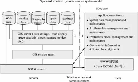
Figure1 The space information dynamic service system model

Figure2 The shortest path diagram
The data information is considered as the foundation for 3DGS and then according to Dijstra-algorithm many routes and required time have been computed and displayed on the system.Meanwhile,the user can choose the optimal one.Guidance for the user is generated to the destination.
Figure2 indicates the entire path from a place to E place.The green color places are the underground space place and the Just B&W show the ground places.Now we can compute the shortest route between A-E through the Dijstra-algorithm(shown in algorithm 1).
As shown in algorithm 1,the shortest path is:0→2→7→13→19,that is,A→B2→C1→D1→E
(2)3D viewpoint vision
Web GIS experiences the development from 2D system to 3D system,and the web GIS based on VRML is the most popular from of the 3D web GIS.3D web GISUses virtual reality technology and visualization technology to construct interactive 3D virtual scene on the Internet,meanwhile also can store,manage,analyze and display the geography information in the virtual environment.At present most of three dimensional Web GIS is based on VRML.Figure 3 is amodel of 3D web GIS(Wang,2008).
Based on the application of Web GIS and VR-based technology,using real three-dimensional simulation of underground space information systems,through the 3D panoramic imaging technology,Graphics Animation System Based on Object Modeling Technique,instant messaging SM interactive technology,shows a three-dimensional guidance through three-dimensional simulation performance of real world with diagrams.It displays3D viewpoint to users and more visualized than 2D video mode.
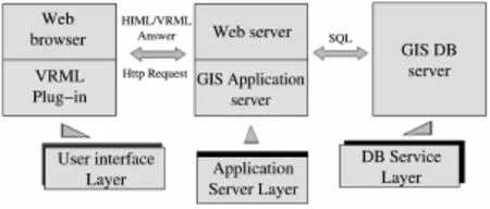
Figure 3 The model of 3D web G IS

Figure 4 The interface of 3DGS
1.3User inter face
The 3DGS can be set in underground space as a production.It can hang up on column and easily show the guidance data in 3D view information.
The system enables users to browse all the information by treating each viewpoint map and corresponding explanation in order.Figure 4 show the interface of a viewpoint generated using 3DGS.
The users can input or search the name of destination on the block of interface,or use the microphone on application-embedded Voice device aside for disabled people.From menu,you can use any searching way you liked.Besides,you can get the information of latest news and hot issues including weather.The system prepares guiding contents with several links which guide user to walk along it,and the nearest one defined on the calculated routs is presented according to user current place.The guiding contents include text,photograph and audios,so that the user can understand the direction easily.
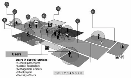
Figure5 A Subway station underground exits plan
2 SIMULATION
Using the method of 3DGS,we have performed a simulation in a part of a city with 3D MAX,NAVISWORKS V3.6,and Vrcontext Walkinside3.5 software.They simulate all the scenes on ground and underground and get all the routes.According to the average walk speed,it computes the different times.
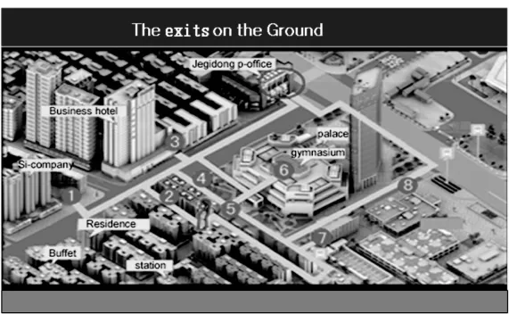
Figure6 A Sunway station ground exits plan
In this section,through the case analysis,the performance of3DGS is shown.Figure5.and Figure6.Shows the plan of layout about a Sunway station including Exits underground and ground;Figure7.(a),(b),(c),show an example of the computing process simulation.We have assumed a user in the underground space and want to go to post office.
Firstly,the users search the destination Jegidon Post office on the searching block.After computing,the 3DGS displays the underground subway line by scheme and many exits to the ground.Secondly,the ground and underground way are figured out.Lastly,all the routes distance and needed time which are calculated by the average walk speed have been displayed from short to long.And finally you have option to choose the optimal one.Schedule and photograph about the whole 3D routes of the journey are also displayed for selection options.
3 DISCUSSION
The simulation results indicate that 3DGS can provide a useful guidance service in underground space.An obvious feature is its capability to compute and display the intelligent routes for user anywhere they want to go.Users can travel to unfamiliar place as well as familiar place using the 3DGS.The system might be beyond human capability to compute the real time and provides the optimal routes even though there are unexpected changes depending on the traffic congestion or other unexpected schedules changed.Figure 3 shows the route guidance interface for interactive route selection,showing the automatic route recommendation after computing.Another feature is3D viewpointon vision.Different from existing 2D map in underground space,it provides a significant advantage.
The device application-embedded Voice and Touch prompt functions assist the mobility and convenience for the disabled people with very simple setting.Sometimes limited by the true environment,further modification is needed for the perfection of the system.On the whole,even though it is just a simulation result,we can still get higher efficiency by using the 3DGS.
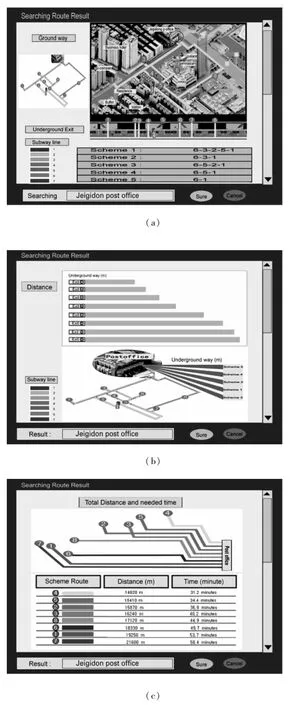
Figure 7:(a),(b),(c)show an example of the computing process
4 CONCLUSION
In this paper,an intelligent guidance system 3DGS have been proposed,integrating GPS,GIS,3D visual technology etc.Through the case simulation of its implementation,feasibility and effectiveness are discussed.3DGS,considers the data route underground and ground information,and thus can guide users to destination quickly with the 3D viewpoint vision.At the same time,the application embedded voice and touch prompt system to support the service for disabled people.It is expected to achieve a significant effect and to play an important role on guidance system in underground space.
A future work of 3DGS is to build basic prototype and text between different audiences.This system has some problems on technology and other issues,so it needs further improvement for its perfect use.It would provide other various services for underground space besides guidance system.There is still a long way to go in the future study to explore the potential for urban underground development.
REFERENCES
[1]Agnew,D.C.and Larson,K.M.(2007).“Finding the repeat times of the GPS constellation”.GPS Solutions(Springer)11(1):71-76.
[2]Bessho,M,Kobayashi,S,Koshizuka,N.&Sakamura,K.(2007)A Pedestrian Navigation System using Multiple Space-Identifying Devices based on a Unique Identifier Framework.ICMLC.
[3]Bessho,M,Kobayashi,S,Koshizuka,N.&Sakamura,K.(2008a)A Space-identifying Ubiquitous Infrastructure and its Application for Tour-guiding Service.ACM New York,NY,USA.
[4]Bessho,M,Kobayashi,S,Koshizuka,N.&Sakamura,K.(2008b)uNavi:Implementation and Deployment of a Place-Based Pedestrian Navigation System.Computer Software and Applications,2008.COMPSAC'08.32nd Annual IEEE International,1254-1259.
[5]Chang,K.T.(1989).“A comparison of techniques for calculating gradient and aspect from a gridded digital elevation model”.Bulleted list item International Journal of Geographical Information Science 3(4):323-334.
[6]Chang,K.T.(2008).Introduction to Geographical Information Systems.New York:McGraw Hill.p.184.
[7]Clarke,K.C.,(1986).Advances in Geographic Information Systems,Computers,Environment and Urban Systems,Vol.10,pp.175-184.
[8]Dijkstra,E.W.(1959)A Note on Two Problems in Connection with Graphs.Numerische Mathematik,1,269-271.
[9]Li Guo,C,You Min,Z.,Zhengru,Y.&You Shan,Y.(1991)Urban Underground Space Development and Civil Defence Construction-A Specia Problem's S.D.Model.System Dynamics,294-303.
[10]Liu,X.,Corner,M.&Shenoy,P.(2006)Ferret:Rfid Localization for Pervasive Multimedia.Lecture Notes in Computer Science,4206,422-440.
[11]James R.Akerman(2006)Cartographies of Travel and Navigation,The university of Chicago press.
[12]Massatt,Paul;Wayne Brady(2002).“Optim izing performance through constellation management”.Crosslink:17-21.
[13]Michael F.,(2010).Twenty years of progress:GIScience in 2010.Journal Of Spatial Information Science Number 1 pp.3-20.
[14]Michael Russell Rip,James M.Hasik(2002).The Precision Revolution:GPS and the Future of Aerial Warfare.Naval Institute Press.p.65.
[15]Nakayama,O.T Itoh,H Ueno(1989)Navigation system for automotive vehicle with automatic navigation start and navigation end point search and automatic route selection,US Patent.
[16]Nowakowski C,P Green,O Tsimhoni(2003)Common automotive navigation system usability problems and a standard test protocol to identify them,Intelligent Transportation Society.
[17]SKim,JH Kim(2002)Adaptive fuzzy-network-based C-measure map-matching algorithm for car navigation system,Industrial Electronics,IEEE Transactions.
[18]Wang,M.(2008)A 3DWeb GIS System Based on VRML and X3D.Genetic and Evolutionary Computing,2008.WGEC'08.Second International Conference on.
【Acknowledgement】 This research was supported by a grant(07KLSG04)from Cutting-edge Urban Development-Korean Land Spatialization Research Project funded by Ministry of Land,Transport and Maritime Affairs.
【作者简介】吕淑贤(1981-),女,博士研究生。主要研究方向:以BIM信息为基础的建筑室内外空间设计,数字化城市设计等计算机辅助建筑设计方法。E-mail:sara_icerose@hotmail.com
【Corresponding Author】Lu ShuXian(1981-),Female,PhD Candidate.The main research direction:computer-aided design methods about architecture cyberspace and digital urban space based on BIM.E-mail:sara_icerose@hotmail.com
Lu Shuxian1,Huang Menggang2,Jin Jin3
(1.Dept.of Housing and Interior Design,Yonsei University,Korea;2.School of Civil and Envionmental Enginerring,Yonsei University,Seoul,Korea;3.Architecture Dept.Kyunghee University,Seoul,Korea)
基于空间信息技术的地下空间三维导示系统的研究
吕淑贤1黄锰钢2靳金3
(1.韩国延世大学生活学院居住环境专业;2.韩国延世大学土木环境工程学院;3.韩国庆熙大学土木系)
【摘 要】本文简述了城市地下空间三维智能导示系统。该系统结合GPS、GIS、RS以及网络通信等技术,对整个地下空间信息道路进行三维模拟仿真和最短路径的查询。通过该系统,用户可以自由选择二维或者三维显示界面,快速查找出到达目的地的所有路线以及乘车方法和所需时间,并指示出最优路线。系统还可以提供专门为残疾人设置的嵌入式语音和触摸提示功能。通过仿真结果,证明该系统是可行的并且能够给人们带来方便、提高效率。
【关键词】地下空间;3S技术(GPS,GIS,RS);三维智能导示系统;Dikjstra算法;网络通信技术;三维显示

