An Extreme Drought over South China in 2020/21 Concurrent with an Unprecedented Warm Northwest Pacific and La Niña
Weijie FENG, Marco Y.-T. LEUNG*,, Dongxiao WANG,, Wen ZHOU, and Oscar Y. W. ZHANG
1School of Marine Sciences, Sun Yat-Sen University, Zhuhai 519082, China
2Southern Marine Science and Engineering Guangdong Laboratory (Zhuhai), Zhuhai 519082, China
3Department of Atmospheric and Oceanic Sciences & Institute of Atmospheric Sciences,Fudan University, Shanghai 200433, China
4Guy Carpenter Asia-Pacific Climate Impact Centre, School of Energy and Environment,City University of Hong Kong, Hong Kong, China
ABSTRACT
Key words: drought in South China, ENSO, northwest Pacific warming
1. Introduction
Precipitation from late autumn to early spring, the period for harvesting and sowing in South China, can strongly influence water resources and agricultural production, with remarkable socioeconomic consequences. In the context of global warming, the frequency of regional autumn droughts has increased over subtropical East Asia in recent decades (Wang et al., 2015). In association with urbanization and population growth, water resources have become a crucial factor in the sustainable development of South China (Jiang et al., 2012). Unfortunately, this region is regularly stricken by droughts (Niu and Li, 2008; Zhang et al., 2021). South China suffered from an extraordinarily long-lasting severe drought from October 2020 to March 2021, which resulted in water scarcity and huge agricultural losses.
El Niño/Southern Oscillation (ENSO) is the dominant tropical interannual climate phenomenon on interannual timescales (Rasmusson and Carpenter, 1982) and is a major factor modulating precipitation variations over East Asia(Zhou et al. 2012; Li et al., 2015, 2019b; Yang et al., 2018;Wang et al., 2019). In winter, El Niño usually induces more precipitation over South China and the middle to lower reaches of the Yangtze River, consistent with a weaker-thannormal East Asian winter monsoon (Wang et al., 2008;Zhou et al., 2010). The influence of El Niño can persist into the following summer (Zhang et al., 2007). The situation reverses during La Niña events (Qiu et al., 2017). Apart from the canonical El Niño (eastern Pacific El Niño; EP El Niño), the central Pacific (CP) El Niño exerts distinctly different impacts on precipitation over East Asia (Ashok et al.,2007; Li et al., 2019a; Ma et al., 2020; Xu et al., 2020). A significant reduction in winter precipitation in South China is noted along with a CP El Niño. However, for La Niña events, sea surface temperature anomaly patterns are not distinct, in contrast to El Niño diversity (Ren and Jin, 2011;Ashok et al., 2017; Timmermann et al., 2018). Zhang et al.(2014) showed that the impact of La Niña on autumn precipitation over South China has been relatively stable over the past few decades, leading to significant precipitation deficits over South China. In short, the influence of ENSO on South China precipitation varies depending on its phase and type.
Accompanied by global warming, anomalous circulations and rainfall are expected to persist, amplifying rainfall intensity during mature boreal winter and late summer for both EP and CP El Niño events. Amplification of rainfall related to a CP El Niño seems stronger than that for an EP El Niño, but both are influenced by a moister atmosphere(Wang et al., 2021). Owing to the combined effects of increasing frequency of CP ENSO events concurrent with changes in greenhouse gases (Cai et al., 2015) and the ENSO-like interdecadal climate shift (Zhang et al., 2014; Zhao and Wang, 2016), it is expected that autumn drought frequency over South China will increase (Zhang and Sumi, 2002; Hu et al., 2018). This is mainly attributed to changes in atmospheric circulations and water vapor flux activities (Zhang and Sumi, 2002; Hu et al., 2018).
According to previous studies, sea surface temperature variation in the different oceans may induce anomalous atmospheric circulation and influence the South China climate(Leung et al., 2017; Chen et al., 2018). In addition, a recent study by Li et al. (2018) demonstrates remote influences from the North Atlantic and the equatorial Indian Ocean on early summer precipitation in South China. Chen et al.(2018) showed that cold sea surface temperature anomalies in the tropical western Indian Ocean and the tropical North Atlantic could induce an anomalous anticyclone in the western North Pacific, leading to a positive precipitation anomaly in South China. In addition, the intensity of the western North Pacific subtropical high, which is controlled by the sea surface temperature gradient between the tropical Indian Ocean and the tropical western Pacific, enhances the intensity and frequency of summer precipitation events in South China (He and Zhou, 2015; Fu et al., 2016). Therefore, the precipitation variation in South China is also linked to sea surface temperature variations in other oceans apart from the tropical Pacific Ocean. On the other hand, a large portion of anomalous heating accompanied by anthropogenic warming is stored in the ocean, leading to significant and inequivalent ocean warming (Lee et al., 2015; Volkov et al., 2017). Hence, this study will further examine the contribution of sea surface temperature anomalies to the extremely low precipitation in South China from late autumn to early spring 2020/21.
The remainder of this paper is organized as follows. Section 2 outlines the data and methods applied in this study. Subsequently, section 3.1 shows the impact of water vapor flux on precipitation in South China; section 3.2 illustrates the influence of anomalous sea surface temperature based on statistical analysis; section 3.3 elucidates the results of a simplified atmospheric general circulation model. Finally, section 4 discusses and summarizes the results of this study.
2. Data and methods
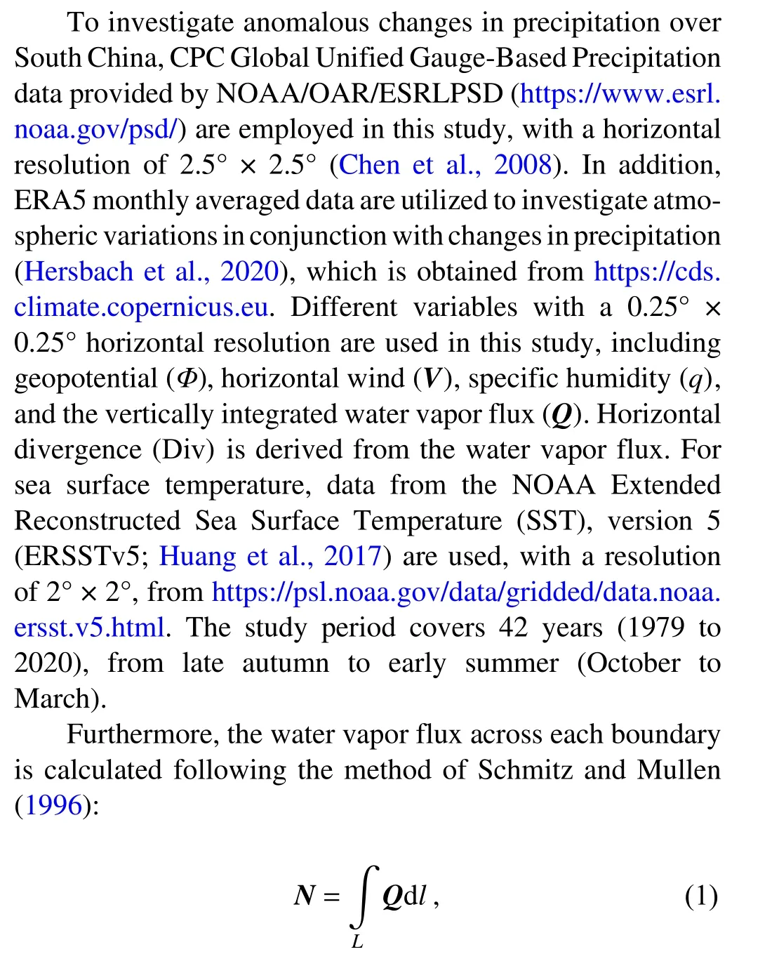
where L represents the length of the boundary.
Linear regression is applied to analyze the influence of sea surface temperature change in the two regions on different atmospheric variables. Linear regression is also employed to remove the ENSO signal and the NWP signal from the variable, with the equations as follows:

whereMXis the linear regression coefficient of specific variableYonto the time series X. In the two equations, the Niño-3.4 index (5°N-5°S, 170°-120°W) is the seasonal average from December to February. The specific variableYand the NWP time series (SST average over 10°-50°N and 120°E-170°W) are relative to a monthly timescale. In addition, the z-test is employed to examine the significance level of the linear trend and the difference between the two samples.
3. Results
Figure 1a shows a precipitation anomaly over South China from October 2020 to March 2021. It is noted that the strongest negative anomaly is centered over northeastern Guangdong Province. According to the distribution of the negative precipitation anomaly, South China is hereafter defined as the region from 23.5°N to 27°N and from 112°E to 118°E (dotted box in Fig. 1a). For the climatological mean, the total precipitation from late autumn to early spring in South China is about 468.42 mm, accounting for only 33.36% of the annual precipitation. Further, robustly low precipitation of 232.26 mm occurs over South China from October 2020 to March 2021 (representing the minimum precipitation dating back to 1979), about half of the climatological mean (Fig. 1b). As shown in Fig. 1c, the precipitation anomaly is primarily due to the negative anomaly in early spring, particularly in March 2021. Therefore, the extremely low precipitation over South China supports the occurrence of the extreme drought event from late autumn to early spring. Hence, we will focus mainly on the cause of this extremely low precipitation in the following subsections.
3.1. The contribution of water vapor flux to the extremely low precipitation over South China
Water vapor flux is a determining factor affecting regional precipitation, as it provides a much greater moisture supply than local evaporation (Trenberth, 1999). Previous studies have indicated that variations in precipitation over East Asia are highly affected by variations in water vapor flux (Wang and Chen, 2012; Leung and Zhou, 2018; Leung et al., 2018). To determine the main causes of the anomalous precipitation in South China, the variation of water vapor divergence is calculated and shown in Fig. 1b. Anomalous low-level water vapor flux divergence is compared with anomalous precipitation, as illustrated in Fig. 1b. A significant negative correlation is apparent between the anomalous water vapor divergence and precipitation, with a Pearson correlation coefficient of -0.89. More importantly, the anomalous water vapor divergence from October 2020 to March 2021 was the greatest since 1979 (Fig. 1b). Therefore, it is necessary to investigate the water vapor flux as it pertains to the anomalous precipitation of this region.
Figure 2 illustrates the vertically integrated water vapor flux and its horizontal divergence. For the climatological mean, the western boundary of South China is the boundary for water vapor input, followed by the southern boundary.The main output boundary is the eastern boundary (Fig. 2a).However, from October 2020 to March 2021, the western boundary was the only water vapor input boundary, as anomalous water vapor output occurred at the southern boundary(Fig. 2b). In addition, we investigated the contribution of the zonal and meridional components of water vapor flux.There is zonal convergence (-1.07 × 10⁷kg s-1) and meridional divergence (0.56 × 10⁷kg s-1) of water vapor from October 2020 to March 2021 over South China (Fig. 2g). Therefore, it is clear that the horizontal divergence of water vapor flux plays an important role in forming extreme drought over South China.
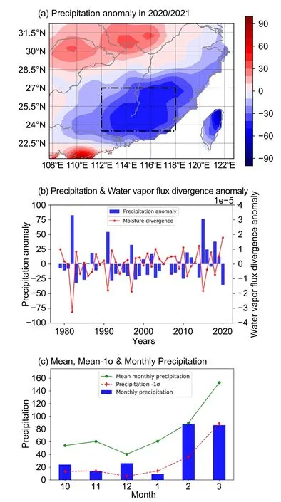
Fig. 1. (a) Monthly average of the precipitation anomaly(shading; mm month-1) in South China from October 2020 to March 2021, with the black box indicating the region defined as South China in this study; (b) monthly average precipitation anomaly (blue bars; mm month-1) and the water vapor flux divergence anomaly (red line; 10-5 kg m-2 s-1) in South China for 1979-2020 (October to March); (c) monthly climatological mean precipitation from October to March (green line; mm),mean precipitation minus one standard deviation (red line; mm)and monthly precipitation (blue bars; mm).
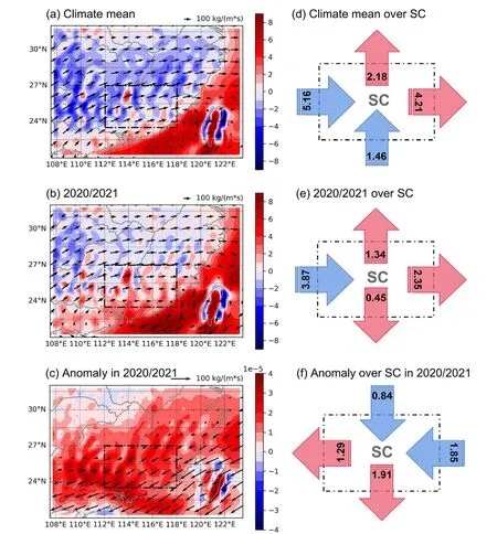
Fig. 2. Composites of water vapor flux (vectors; kg m-1 s-1) and water vapor flux divergence (shading; 10-5 kg m-2 s-1)for (a) the climatological mean and the (b) average and (c) anomaly from October 2020 to March 2021. The water vapor budget for each boundary of South China for (d) the climatological mean and (e) the average and (f) anomaly from October 2020 to March 2021. The numbers in black represent the amount of water vapor (107 kg s-1)transported across each boundary. The arrows in red and blue represent water vapor output and input, respectively,the black box indicating the region defined as South China in this study.
The contribution of horizontal winds and specific humidity is examined to investigate the underlying causes of the changes in water vapor flux (Fig. 3). For the climatological mean, southwesterly winds in the lower troposphere (850 hPa) transfer moisture from the South China Sea into South China (Fig. 3a). From October 2020 to March 2021, the horizontal wind direction in the lower troposphere notably changes, concurrent with anomalous easterly winds west of Taiwan (Fig. 3b). Figure 3c shows anomalous northeasterly wind flow in South China, which generally parallels the contours of anomalous geopotential height at 850 hPa, which implies the geostrophic balance,fk×V≈-∇Φ. Hence the change in northeasterly wind flow is associated with the nature of the geopotential height gradient. In addition, the specific humidity from October 2020 to March 2021 is enhanced compared with its climatological mean (Figs. 3df). Therefore, the change in specific humidity is unlikely to have caused the extremely low precipitation.
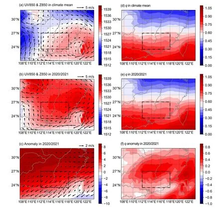
Fig. 3. (a) Climatological mean of UV850 (vectors in m s-1) and geopotential height (shading; m); (b) and (c) similar to (a),but for the average and anomaly from October 2020 to March 2021, respectively; panels (d)-(f) are similar to (a)-(c), but for specific humidity in (d) and (e) (10-2 kg kg-1) and (f) (10-3 kg kg-1), the black box indicating the region defined as South China in this study.
3.2. The influence of La Niña and NWP SST on anomalous water vapor flux divergence
As mentioned above, the anomalous northeasterly winds along with the horizontal gradient of geopotential height at 850 hPa, implies a geostrophic balance between the Coriolis force and pressure gradient force,fk×V≈-∇Φ. This means that the relative intensity of the northeasterly wind in this region is related to the anomalous geopotential height in South China from October to March(Fig. 3c).
To identify the anomalous circulation from October 2020 to March 2021, the geopotential height (Z850) and 850 hPa wind (UV850) anomalies in a larger domain are delineated in Fig. 4a. It is noted that the steeper gradient of geopotential height is attributed to an anomalous positive center along mid-latitude East Asia and the northwest Pacific and a negative center in the South China Sea and surrounding regions.
Since ENSO is an important feature that can cause variations in atmospheric circulation, it is necessary to clarify the contribution of ENSO to the anomalous geopotential height over South China from October 2020 to March 2021. According to the Niño-3.4 index (Fig. 1b), a moderate La Niña event occurred during this period. To investigate its forcing,the ENSO geopotential height signal is removed by linear regression in Fig. 4b, and linear regression of the geopotential height and wind at 850 hPa onto the Niño-3.4 index is delineated for different periods in Figs. 5a-d. The geopotential height and horizontal winds over the northwest Pacific and South China from late autumn to early spring are significantly related to ENSO. This means that the anomalously cold sea surface temperature in Niño-3.4 will be concurrent with the low geopotential height and anomalous northeasterly wind in East Asia and the northwest Pacific. Remarkably, the change in the anomalous wind concurrent with ENSO is more pronounced in autumn to early winter (Figs. 5b-c).According to Wang et al. (2000), ENSO could induce anomalous winds over the western North Pacific that develops rapidly in late fall when a strong cold event matures. The anomalies persist until the following spring or early summer,causing anomalously dry conditions in South China. Hence,La Niña supports a steeper horizontal geopotential height gradient over South China, which exists in tandem with anomalous northeasterly winds.

Fig. 4. (a) Composites of UV850 (vectors; m s-1) and geopotential height (shading; m) anomaly from October 2020 to March 2021 in EA-WP; panels (b) and (c) are similar to (a),but for the ENSO-removed and NWP-removed UV850 and geopotential height, respectively, the black box indicating the region defined as South China in this study.
Nonetheless, the moderate La Niña from October 2020 to March 2021 only partly explains the extreme drought in South China. Should the ENSO geopotential height signal be removed by linear regression, we find that the negative center of geopotential height in the South China Sea is weakened substantially, and the anomalous northeasterly winds over South China are still controlled by a steeper gradient of geopotential height (Fig. 4b). Notably, the positive geopotential height anomalies along mid-latitude East Asia cannot be explained by La Niña (Figs. 5a-d). In addition, the average geopotential height along mid-latitude East Asia (30°-40°N and 108°-120°W) reached a historical peak (Fig. 6b; blue line). Consequently, the positive geopotential anomaly is the other factor that contributed to the steeper gradient of geopotential height over South China from October 2020 to March 2021, which resulted in horizontal wind anomalies.
Figure 6a shows an anomalously warm sea surface temperature signal found over the northwest Pacific (NWP;10°-50°N and 120°E-170°W). The time series of the average sea surface temperature over the NWP is indicated by the red line in Fig. 6b. It shows a significant increasing trend and consistent decadal variation. It is also noted that the NWP sea surface temperature from October 2020 to March 2021 is the highest since 1979. Additionally, the regression of geopotential height and wind at 850 hPa onto NWP sea surface temperature is delineated during different periods in Figs. 5e-h. A positive signal of geopotential height is found over mid-latitude East Asia, and the anomalous horizontal winds occur along the southern boundary of South China in early spring (Fig. 5e; The anomalous northeasterly wind is noted at the southern boundary of South China). In addition,the change in geopotential height concurrent with warm NWP SST anomaly is more pronounced in early spring,which is different from that of ENSO (Fig. 5h). As shown in Fig. 5, ENSO and NWP SST both play a role, yet with different seasonalities. ENSO contributes to the wind anomalies in autumn to early winter, while the NWP SST plays a more important role in early spring.

Fig. 5. (a) Linear regression of UV850 (vectors; m s-1 K-1) and geopotential height (shading; m K-1) onto the Niño-3.4 index; panels (b), (c), and (d) are similar to (a), but for late autumn, winter and early spring, respectively. The right panels are similar to the left panels but for the NWP-SST index. In this figure, only values that are significant at the 0.05 level or better are plotted, the black box indicating the region defined as South China in this study.
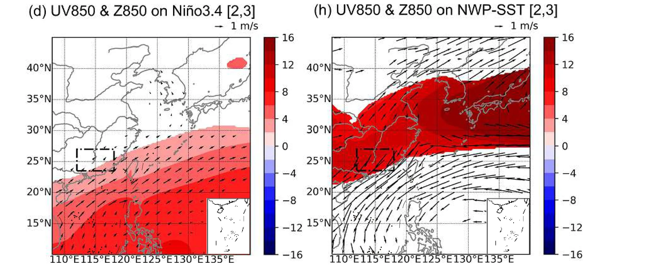
Fig. 5. (Continued).
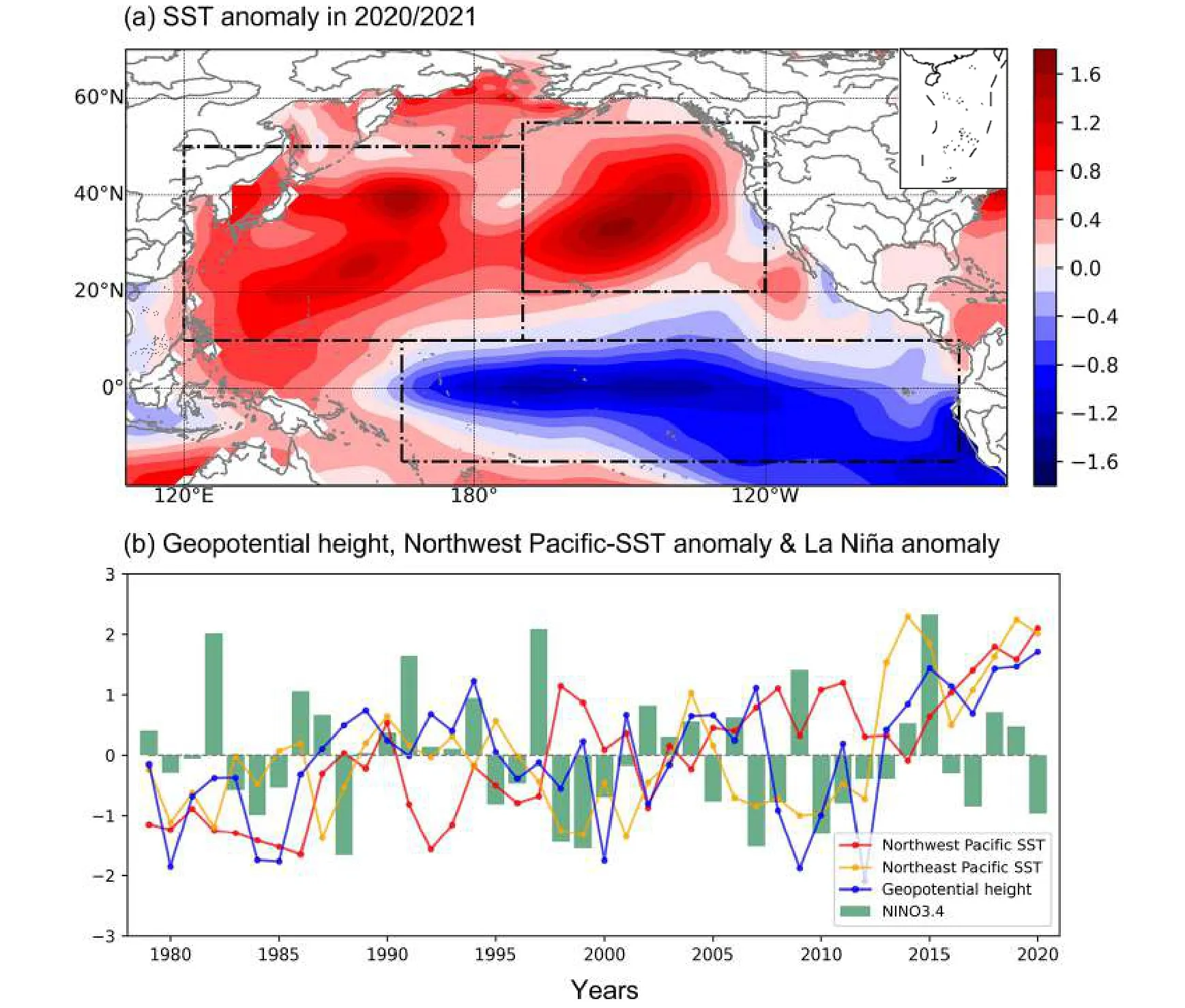
Fig. 6. (a) The average monthly Pacific Ocean sea surface temperature anomalies (shading; K) from October 2020 to March 2021, with black boxes indicating the NWP, NEP, and TEP sea surface temperature regions; (b) Standardized NWP sea surface temperature (red line), NEP sea surface temperature (orange line), geopotential height along mid-latitude East Asia (blue line) and Niño-3.4(green bar) indices for 1979-2020 (October to March).
If the NWP geopotential height signal is removed by linear regression, we find that the positive geopotential heights over mid-latitude East Asia are weakened substantially, and the anomalous northeasterly winds over South China also weaken (Fig. 4c). Hence, the warm anomaly in the NWP could potentially lead to steeper geopotential height gradients and anomalous winds over South China from October 2020 to March 2021.
3.3. Numerical simulation of the geopotential height anomaly induced by an anomalously warm NWP
A simplified atmospheric general circulation model from the International Center for Theoretical Physics is utilized to clarify the causal relationship between the NWP warm anomaly and the positive height anomaly in East Asia(Molteni, 2003; Kucharski et al., 2006, 2013). This model has been used to investigate the atmospheric response to anomalous sea surface temperature in previous studies (Jian et al., 2020, 2021; Leung et al., 2020; Gore et al., 2020).The model is configured with T30 spectral truncation resolution and eight vertical levels in σ-coordinates. The climatological mean sea surface temperature initially drives the model for 140 years. The first 10 years are used for model spin-up;the remaining years are taken as the control simulation (Control_Run) and the initial condition for the sensitivity simulation. A paired Z-test is employed to examine the difference between the Control_Run and the sensitivity simulations.
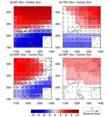
Fig. 7. (a) Difference in 850 hPa geopotential height (m) and wind (m s-1) between the NP_Run and Control_Run simulations; (b), (c), and (d) are similar to (a), but for the TEP_Run, NWP_Run, and NEP_Run,respectively. In this figure, only differences that are significant at the 0.05 significance level or better according to a paired t-test are plotted, the black box indicating the region defined as South China in this study.
A sensitivity simulation (NP_Run) is driven by the anomalous SST in the North Pacific, whose domain is illustrated in Fig. 6. As presented in Fig. 7a, the NP_Run reveals a significant positive geopotential height difference in midlatitude East Asia and a negative difference in the South China Sea and surrounding regions. The change in the geopotential height gradient is concurrent with significant northeasterly winds in South China. This implies that the anomalous North Pacific SSTs could drive the anomalous atmospheric circulation in East Asia and West Pacific from October 2020 to March 2021.
Furthermore, the other three simulations are carried out to investigate the contribution of different parts of the Pacific to the anomalous northeasterly wind in South China from October 2020 to March 2021. As shown in Figs. 7b-d,the anomalous sea surface temperature added to tropical eastern Pacific (TEP; 15°S to 10°N and 165°E to 80°W), NWP(10°N to 50°N and 120°E to 170°W) and Northeast Pacific(NEP; 20°N to 55°N and 170°W to 120°W) from October to March are prescribed to the sensitivity simulations(TEP_Run, NWP_Run, and NEP_Run), respectively.
As illustrated in the TEP_Run (Fig.7b), the cold anomaly in the tropical eastern Pacific cannot directly induce the northeasterly wind in South China because the model lacks the atmospheric forcing on the ocean, which suggests that the air-sea interaction is important for connecting the tropical eastern Pacific SST anomaly and South China precipitation. In the NWP_Run (Fig. 7c), anomalous northeasterly winds are noted over South China and are induced by the anomalously warm NWP. Hence, the results of numerical simulations emphasize that the NWP could be a crucial factor that transfers the La Niña signal to the anomalous northeasterly winds in South China. This also points out the importance of an unprecedented warm NWP during the extreme drought from October 2020 to March 2021 in South China.In addition, the sea surface temperature average over the NEP reaches a high value (Fig. 6b; orange line). The sensitivity simulation (NEP_Run), driven by the warm anomaly in the Northeast Pacific, is employed to explore its influence on the extreme drought event in South China. As shown in Fig. 7d, a warm NEP SST anomaly exerts a negligible contribution to the atmospheric circulation anomaly in South China.

Fig. 8. Schematic diagram presenting the air-sea interaction in the western North Pacific, red (blue) shading indicates positive (negative) SST anomalies. Thick green arrows and contours show anomalous horizontal wind and geopotential height at 850 hPa in 2020/21.
4. Summary and discussion
This study suggests a possible physical mechanism to explain the extreme drought from late autumn to early spring over South China from October 2020 to March 2021.The extremely low precipitation is attributed not only to a moderate La Niña, which contributes significantly in autumn to early winter, but also to the NWP warm anomaly that plays a more important role in early spring. The result is summarized in a schematic diagram (Fig. 8). In La Niña,the cooling in the central Pacific could induce a warm anomaly in the NWP SST (Wang et al., 2000). This conjecture supports the unprecedented warm anomaly in the NWP,which causes a positive geopotential height anomaly over mid-latitude East Asia and a negative height anomaly over the South China Sea and surrounding regions. The resulting steeper geopotential height gradient that formed over South China was oriented from the northwest to the southeast and contributed to anomalous northeasterly winds. Therefore,owing to the combined effect of the anomalously warm NWP and the moderate La Niña, water vapor flux input was suppressed from October 2020 to March 2021 over South China.
Furthermore, we also confirmed the contribution of the anomalous winds and water vapor flux to the maximum water vapor flux divergence from October 2020 to March 2021 (Figs. 2c and 3c). Previous studies have illustrated the formation of anomalous northeasterly winds due to La Niña(Zhang et al., 2019a, b; Wang et al., 2000). Nonetheless, we emphasize the NWP sea surface temperature’s forcing on the anomalous geopotential height and horizontal wind in the lower troposphere over South China, particularly on decadal timescales. A simplified atmospheric general circulation model also confirmed this result. Therefore, it is important to consider the synergistic effect of an NWP warm anomaly and La Niña on drought intensity and frequency over South China. Apart from an NWP warm anomaly and La Niña, winter droughts in South China could also be induced by the Eurasian teleconnection (Geng et al., 2021),which may have also influenced the extremely low precipitation in South China from October 2020 to March 2021.
Our study demonstrates a corresponding role of anomalous NWP sea surface temperature in modulating water vapor transport and drought risk over South China. The lowfrequency variation in NWP sea surface temperature could be periodically controlled by the Pacific Decadal Oscillation on decadal timescales (Mantua and Hare, 2002; Wang and Liu, 2016), which may lead to decadal variations in precipitation and drought occurrence over South China. In addition,there is significant background warming in the NWP (Watson et al., 2001; Hansen et al., 2006), which may lead to a decrease in precipitation over South China and more extreme drought events from late autumn to early spring in the future. According to the future projections of CMIP5 simulations (Zhou et al., 2019), the precipitation in South China will decrease when global temperatures rise to 1.5°C above pre-industrial levels but will increase with warming above 2°C. These results suggest that the trend in South China precipitation may be altered when global temperature increases by 2°C relative to the pre-industrial period.
Acknowledgements. This study was jointly supported by the National Natural Science Foundation of China (Grant No.41805042) and the Science and Technology Program of Guangzhou, China (Grant No. 202102020939).
 Advances in Atmospheric Sciences2022年10期
- Advances in Atmospheric Sciences的其它文章
- An Unprecedented Record Low Antarctic Sea-ice Extent during Austral Summer 2022
- 2021: A Year of Unprecedented Climate Extremes in Eastern Asia,North America, and Europe
- Transport Patterns and Potential Sources of Atmospheric Pollution during the XXIV Olympic Winter Games Period
- Observational Subseasonal Variability of the PM2.5 Concentration in the Beijing-Tianjin-Hebei Area during the January 2021 Sudden Stratospheric Warming
- How Well Do CMIP6 and CMIP5 Models Simulate the Climatological Seasonal Variations in Ocean Salinity?
- How Frequently Will the Persistent Heavy Rainfall over the Middle and Lower Yangtze River Basin in Summer 2020 Happen under Global Warming?
