Lightning Nowcasting with an Algorithm of Thunderstorm Tracking Based on Lightning Location Data over the Beijing Area
Abhay SRIVASTAVA, Dongxia LIU, Chen XU, Shanfeng YUAN, Dongfang WANG,Ogunsua BABALOLA, Zhuling SUN, Zhixiong CHEN, and Hongbo ZHANG
1Key Laboratory of Middle Atmosphere and Global Environment Observation (LAGEO),Institute of Atmospheric Physics, Chinese Academy of Sciences, Beijing 100029, China
2Space and Atmospheric Science Division, North Eastern Space Applications Centre,Department of Space, Meghalaya 793103, India
(Received 6 December 2020; revised 13 August 2021; accepted 17 August 2021)
ABSTRACT A thunderstorm tracking algorithm is proposed to nowcast the possibility of lightning activity over an area of concern by using the total lightning data and neighborhood technique. The lightning radiation sources observed from the Beijing Lightning Network (BLNET) were used to obtain information about the thunderstorm cells, which are significantly valuable in real-time. The boundaries of thunderstorm cells were obtained through the neighborhood technique. After smoothing, these boundaries were used to track the movement of thunderstorms and then extrapolated to nowcast the lightning approaching in an area of concern. The algorithm can deliver creditable results prior to a thunderstorm arriving at the area of concern, with accuracies of 63%, 80%, and 91% for lead times of 30, 15, and 5 minutes, respectively. The realtime observations of total lightning appear to be significant for thunderstorm tracking and lightning nowcasting, as total lightning tracking could help to fill the observational gaps in radar reflectivity due to the attenuation by hills or other obstacles. The lightning data used in the algorithm performs well in tracking the active thunderstorm cells associated with lightning activities.
Key words: neighborhood technique, lightning nowcasting, thunderstorm tracking, lightning location data
1. Introduction
Lightning can damage properties and increase the risk of human injury. Holle (2008) reported a worldwide annual fatality rate that could be as high as 24 000 per year or, equivalently, six deaths per million people. In some regions, lightning shows a significant increasing trend (Romps et al.,2014; Qie et al., 2020a, 2021), and may lead to increased fatalities and future economic losses. Therefore, to reduce the risk of injury, wildfire, and damage caused by lightning in densely populated areas, the development of an early warning system for lightning activity in an area of concern(AOC) has become essential. Residents of communities or users of public areas, such as farms, airports, stadiums,schools, recreational facilities, and other similar areas, usually benefit by knowing the occurrence of thunderstorms and lightning in advance. For example, airport operations are affected by disruptions in ground maintenance, and flight takeoff and landing and may not proceed efficiently due to frequent lightning strikes.
A lightning warning should be initiated at the beginning of a thunderstorm and earlier than the first lightning flash over a selected larger Warning Area (WA) and another warning should be given before the thunderstorm reaches over the AOC (Aranguren et al., 2009; Yair et al., 2010;Murphy et al., 2016). These lightning warnings can be implemented in a fixed-point or continuous storm tracking method within a few minutes to hours of lead time (Betz et al., 2008; Srivastava et al., 2015). Various data and instruments like electric field mills, lightning location systems, Meteosat infrared imagery, and single-site meteorological observations have been applied to lightning warnings in an AOC up to hours of lead-time (Karagiannidis et al., 2016; Bennett, 2018). These types of forecasting have been improved using stochastic methods and artificial intelligence (Németh and Kiss, 2009; Srivastava et al., 2015). Recently, machine learning has been proposed to predict the occurrence of lightning within a selected location and time interval by using weather data (Moon and Kim, 2020).
Lightning is closely associated with the vigor of the updraft in convective cells, but typically, the forward pathway of convective cells cannot be perfectly predicted due to stochastic changes in speed and direction (Murphy and Holle, 2006). Nevertheless, the use of total lightning data alone [in consideration of both the intra-cloud (IC) and cloud-to-ground (CG) lightning] can play a vital role in thunderstorm tracking and lightning warning (Betz et al., 2008).Other than this, EarthNetwork (a commercial network)shows dangerous thunderstorm alerts (DTAs) using lightning data around the WA (Stock et al., 2018). However, lightning location network tracking references do not give a detailed methodology, and observers can only make assumptions based on real-time observations and experience. Apart from lightning data, other thunderstorm tracking methods such as radar data are widely used (e.g., Dixon and Wiener,1993; Johnson et al., 1998; del Moral et al., 2018). Based on radar data, thunderstorm tracking has approached reasonable goals. We believe that the full detailed methodology and tracking will open a new direction for research and applications regarding improvements in thunderstorm tracking with lightning location networks used in combination with radar- and satellite-based observations. Thus, a comprehensive thunderstorm tracking methodology can benefit by using total lightning data in addition to radar data.
Once thunderstorm tracking issues a lightning warning over the AOC, an associated concern is to forecast the possibility of severe weather (hail, strong winds, flash floods, and other associated events). As we know, a lightning warning and severe weather can coexist over an AOC simultaneously. Based on lightning location network data, several methods have been introduced to initiate a severe weather warning, including the lightning jump algorithm and the changes in the dominant positive CG (Schultz et al., 2009,2011; Chronis et al., 2015; Miller et al., 2015; Farnell et al.,2017). Williams et al. (1999) suggested that short-term increases of IC flash rate are correlated with rapidly developing strong convection, which can often be followed by severe weather. A severe weather identification method has been implemented separately without considering thunderstorm tracking or AOCs over Beijing (Tian et al., 2019).This study mainly focuses on thunderstorm tracking and lightning warnings over an AOC, and is separate from the issuance of a severe weather warning.
In this work, we will introduce a thunderstorm tracking algorithm using a lightning location network, track the moving path of a thunderstorm, and predict thunderstorms and lightning with a suitable lead time. The total lightning (CG strokes and IC pulses) data are employed to identify the suspect convective cells and to warn of possible lightning in an AOC. In addition, neighborhood and smoothing techniques are utilized to distinguish the boundaries of convective cells. Furthermore, radar reflectivity is used to validate the identified cells with the total lightning data. Thunderstorms with total lightning data are used to examine the forecast accuracy in the AOC. Here, only lightning location data is used in the proposed algorithm, which is the simplest to implement. Thus, only the convective cells with active lightning activities can be tracked.
The remainder of this paper is organized as follows: Section 2 outlines the lightning and radar data, section 3 discusses the approach and methodology of the algorithm, section 4 reviews the observational results from three case studies, and section 5 provides a summary and conclusion.
The algorithm discussed in this paper could be extended to severe weather warnings in an AOC, but this paper provides only an outline for implementing a severe weather warning over an AOC and does not focus explicitly on severe weather.
2. Data
2.1. Lightning data
The analyzed lightning dataset is acquired from the summer campaigns of the “Dynamic-microphysical-electrical processes in severe thunderstorms and lightning hazards(Storm973)” Program (Chen et al., 2019; Liu et al., 2020;Lu et al., 2021; Qie et al., 2020b). A lightning location network developed in Beijing, China, named the Beijing Lightning Network (BLNET), includes 16 stations. These stations are distributed in various locations in Beijing with a range of 110 km from east to west and of 120 km from north to south, and each station has multi-frequency band(VHF, LF, VLF) sensors (see Fig. 1). The real-time lightning locations are obtained by a LF sensor network with a frequency bandwidth from 1.5 kHz to 2 MHz (Wang et al.,2016). The BLNET can detect total lightning (CG and IC)with high detection efficiency (DE) and good location accuracy (LA) (Srivastava et al., 2017). Cloud to ground (CG)strokes and IC pulses are differentiated based on a sensor waveform. The BLNET performance, as evaluated by Srivastava et al. (2017), disclosed a DE of 93.2% and a LA of 52 meters achieved in three dimensions. The total lightning activities are consistent with the radar reflectivity, which helps to validate the identified thunderstorm.
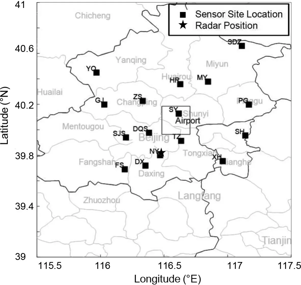
Fig. 1. All 16 sites of BLNET are shown as black squares distributed in the range of around 110 km from east to west and 120 km from north to south.The gray box is near the Capital Airport area, which represents a warning area. The radar is located near the NY sensor and is marked with a star.
2.2. Radar data
The radar reflectivity used in this study is obtained from the Chinese meteorological administration's S-band Doppler radar, which is located in the southern part of Beijing (39.814°N, 116.472°E). It covers a 230 km radius and conducts nine-level elevation scans (0.5°-3.4°) with 6-minute intervals. The composite radar reflectivity is used in this study.
3. Methodology for forecasting and warning
In this section, the thunderstorm tracking and the lightning forecasting algorithms are described in five basic steps.To explain the methodology, we assumed some parameters,as shown in Fig 2. At the instant time TO2 that is equal to TF1,the assumptions are: (i) Cell A is at X02 and cell B is at XF1.(ii) Cell B started from X01 at time TO1 further back than cell A. (iii) In the next step after time TF1, the corresponding positions of cell A and cell B will be XN2 and XN1, respectively. (iv) The ellipse is the forecasted cell over XN at the time TN that is the same as TN1 or TN2.Based on the nature of these assumptions, the tracking and forecasting details will be given in the following subsections.
3.1. Cell identification
The lightning pulses (lightning radiation sources)obtained by BLNET are converted into a density map in real-time. In the cell identification process; first, the area of observation is converted to grids with the size of 4 km by 4 km. The total numbers of pulses located in each grid are counted in 10-minute intervals, which are updated every two minutes according to the latest observations. The 10-minute selection could vary for different networks based on the available data sets. However, the 2-minute update is fixed to observe the sudden changes earlier and to reduce the blackout time. It is assumed that if the total number of pulses occurring in the grids exceeds a certain threshold then those grids are considered active. Here, we considered the threshold to be five, which is an arbitrary number and is dependent on the performance of a particular network. By the observation of BLNET, more than 400 pulses could be located for a single flash (Srivastava et al., 2019; Yuan et al., 2020). During the initial stage of development, we overlapped radar and lightning data to choose the grid size and found that most grids of cells exceed the threshold. Although few of the cells have less than five pulses, and sometimes even one or two pulses, that did not overlap with the radar, we assume that there could be detection errors in the lightning location system. Excluding those grids below the threshold,the confidence of the density map is enhanced. Thenceforth,all the active grids were used to obtain the boundaries of thunderstorm cells using the neighborhood technique. The neighborhood technique suggests that all grids connected in any of the eight directions are from the same cell (Gonzalez et al., 2004). An example is shown in Fig. 2; all the active grids marked in gray are divided into two cells. These cells are denoted as cell A and cell B, and their boundaries are identified, which are symbolized by black polygons. To facilitate easy understanding of the pictures and in the interest of being user-friendly, the density map will not be shown inthe results section.
3.2. Cell tracking
As the identified boundaries of thunderstorm cells are not precise enough for tracking, we smooth the boundaries by using the moving average method. Two different approaches were considered in locating the centroid of the cell for tracking the thunderstorm path. The first approach took each active grid with a number of pulses below a given threshold (a threshold value of 25 was considered for the cases consider in this paper, the selection of threshold depends on the performance of the lightning location network). By doing this, the centroid is directly acquired from the mean of the obtained points from the polygon boundaries. In the second approach, for a cell of grids with their numbers of pulses larger than that of the threshold pulses, the grid with the highest number of pulses was considered the centroid of that particular cell. The obtained centroid is considered as the initial position of the cell, thereafter, the same procedure is used to identify the following positions in a 2-minute interval. The 10-minute density maps with cell identification were updated every two minutes by following the new observations, as explained in the previous section.Based on these centroids, the direction and displacement of a thunderstorm were obtained.
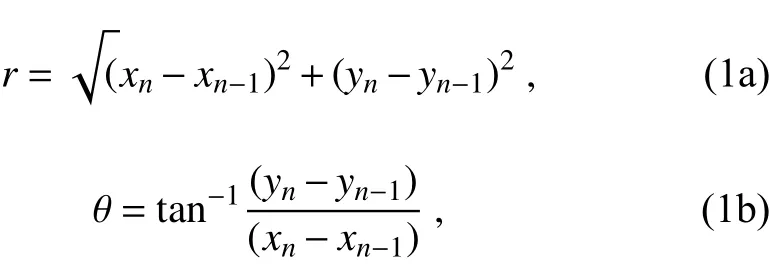
Here we took the centroid position at (xn,yn) and the previous centroid position at (xn-1,yn-1). Then the displacement and direction of a thunderstorm are obtained using Eqs. (1a) and (1b):In Fig. 2, the path of a thunderstorm is shown in black arrows. Here, TO1 represents the initial time at the starting location of the thunderstorm, and TF1 shows the present position of the identified cell.
3.3. Cell merging and splitting
Over the course of the lifecycle, it is commonly observed that it could merge into a strong extensive convective system, or split into smaller cells, which might go on to be identified as more than one cell. The single-cell, multicell, and squall lines are the usual classifications of thunderstorms, and splitting or merging could happen more than once with a multi-cell or in a squall line. A single cell indicates that no merging or splitting occurred in the system. The merging process considered in this article is simulated by converting two or more adjoining cells into a single cell considering the mutual direction of all the convective cells. This direction is obtained using Eq. (2) and an example is shown in Fig. 2.

Here, TNi(whereiindicates the number of the cell)shows the position of each cell, and TN is the average position. The merging process usually happens between the developing and mature stages of a thunderstorm. Conversely, splitting is a process in which a single cell or squall line divides into multi-cells. To obtain this, we consider the discontinuity due to voided grids in the primary cell to split the primary cell into multi cells. The splitting process may occur during any stage of thunderstorm development. Consequently, during the process of splitting and merging, this algorithm tracks the direction of a thunderstorm instead of a single cell.
3.4. Extrapolation
Based on the above section, updated direction and displacement of thunderstorm cells are determined, and the possible forecast positions of the cells can then be acquired.The algorithm now considers only the first 10 minutes as the initial condition, which is updated every two minutes,and the direction and displacement are determined for each new position. The 2-minute interval was selected to avoid the sudden changes in the possible moving direction that results due to a higher sampling rate. Here, the displacement of the thunderstorm is obtained via Eq. (3).

whereCrepresents the displacement at every updated instance,jrepresents the forecast instance, andIirepresents the displacement and direction at theith instance.
In Eq. (3), the averaging is performed to improve the accuracy of the thunderstorm movement in case of a sudden increase in total lightning at any grid. Further, it also reduces the errors from a large pulse density which can accompany long-duration flashes. As shown in Fig. 2, XF1 is the present position and XN is the forecasted position of the thunderstorm. The new position of the cell needs to be determined in the time needed to issue a lightning warning in the AOC. Another benefit of the 2-minute sampling output would also allow for the lightning data to be fed into a severe weather warning algorithm, which is beyond the scope of this work.
3.5. Nowcasting and warning
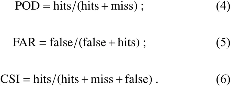
Based on the thunderstorm tracking methodology, the thunderstorm is nowcasted at the AOC at various lead times. The performances of the forecasting methods are evaluated in terms of the probability of detection (POD), the false alarm rate (FAR), and the critical success index (CSI), as shown in Table 1. In this work, we propose that a warning would be generated if any cell reaches the AOC (the graycolored square in Fig. 3), within the expected time. The warning system is tested based on the available data and the warning capability is discussed according to the POD and FAR.The criteria for testing the algorithm included the number of hits determined correctly (Hits), false alarms (False), and missed cases (Misses). The “Hits” are defined when the current observed position overlaps with the corresponding previous forecast position. The “False” is defined when none of the current observed positions overlap with the corresponding previous forecasted positions. The “Miss” is defined when the current observed positions are available but none of them correspond with the previous forecast positions.The evaluations of the forecasting methods are done based on the above rules and are shown in Fig. 3, which can be formulated as:
4. Results
We have selected a small area within the range of BLNET (refer to Fig. 1) to test the warning algorithm by using the thunderstorm tracking procedure. Based on the above methodology, 1159 cases from 57 thunderstorm days were tested around the AOC, and they were selected for testing the prediction performance according to the types of thunderstorms. We randomly chose this AOC in a densely populated area that is larger than the airport. The different performances with lead times of 5, 15, and 30 minutes are shown in Table 1. It shows that the capability of the algorithm for nowcasting decreased with increase thunderstorm prediction lead time. For the 5-minute lead time, the POD reaches 91.0% and the FAR is 2.1%. As the FAR could be influenced by the downtime of the lightning location network,the nominal FAR is obtained after excluding this downtime.For 15-minute and 30-minute lead times, the PODs are 80.0% and 62.8%, in which the FARs are 21.8% and 33.3%, respectively. Table 1 clearly shows that the CSI decreases with increasing lead time, and it is 47.8% for 30-minute intervals. It should be noted that the prediction capability can be influenced by the size of the selected AOC, i.e. an average prediction will be obtained for a smaller size of AOC.
Different colors were designated to show the distinctaspects of the developed warning system (Fig. 5). The nowcasting starts red and fades to light red (forecasted thunderstorm) as time elapses from 5 to 30 minutes. In the last section of the process, an AOC is shown in a green rectangle.For the validation of thunderstorm tracking, three observed cases of thunderstorms are discussed, of which two cases occurred in 2017, and one occurred in 2018. In addition, the lightning events and the corresponding composite radar echo of a thunderstorm are presented.
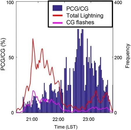
Fig. 4. The lightning flash rate on 7 July 2017. The left-hand axis shows the percentage of PCG/CG and the right-hand axis shows the number of flashes per two minutes.
4.1. Case 1
On 7 July 2017, a thunderstorm developed and moved to the southeast, affecting most of the Beijing area. Figure 4 shows the variation of lightning flash rate and percentage of positive CG (PCG) and CG lightning, based on the BLNET data. The lightning flash rate exceeded 260 flashes per two minutes around 2100 LST (Local Standard Time, LST =UTC + 8). Figure 5a shows an example at 2130 LST with all the nowcasted lead-time predictors in the AOC. Figure 5b shows that at 2148 LST, few grids of the convective cell overlapped with the active grids of the identified cell. During this period, the storm was in a mature stage, and the centroid moved from northwest of the Airport to Tongzhou(an approximate distance of 22 km) with a speed of 73 km h-1. At 2100 LST, the pathway of the convective cell was overlapped with a few grids of the AOC. Ten minutes later, the thunderstorm arrived at the northeast corner of the AOC marked in a yellow color (thunderstorm cell of a polygon) in Fig. 5a. After the first warning, the algorithm was continuously nowcasting every five minutes until the thunderstorm passed over the selected region at 2145 LST. Furthermore, the second phase of cell tracking started at 2305 LST.The thunderstorm was nowcasted in the next possible 15 minutes, although another warning was generated within 5 minutes. Then the thunderstorm arrived over the AOC from the southeast corner at the expected time of 2320 LST, and the continuous warning was generated until the thunderstorm passed over the AOC. The algorithm initially predicted that the thunderstorm would pass the selected area at 2335 LST, but it actually left the AOC after 2345 LST as another warning was generated at 2340 LST. The possible reason for this was that the speed of the thunderstorm was slowing down as it went through the AOC. Later, the thunderstorm was too weak to continue the warning before it passed over the AOC. The corresponding radar reflectivity is shown in Figs. 5c and 5d. The strong radar echo ( > 45 dBZ)is approximately in the same place as the identified cell(using total lightning data), which indicated that the radar echo of the thunderstorm is in good agreement with the total lightning observation.

Fig. 5. The real-time prediction and warning on 7 July 2017. The dark red cell shows a presently identified cell. The thunderstorm’s movement is forecasted in five-minute intervals displayed with the fading red cells. The blue line shows the historical positions of the initial thunderstorm when it reached within the range of BLNET. The color bar in panels (a) and(b) shows the time of the one-hour historical cells identified using total lightning. (a) The thunderstorm cell from lightning data at 2130 LST, (b) thunderstorm cell from lightning data at 2148 LST, (c) thunderstorm cell from radar echo at 2130 LST,(d) thunderstorm cell from radar echo at 2148 LST.
4.2. Case 2
On 13 July 2017, a squall line lasted for six hours and was associated with hail and heavy rainfall. A forecasted convective cell overlapped with the warning area at 2058 LST,and the nowcast indicated that the thunderstorm would arrive over the warning area within 30 minutes. Due to the vigorous intensity of the thunderstorm, another warning was started for the next 15 minutes, at 2110 LST. From 2058 LST to 2110 LST, the 30-minute nowcast continued to indicate the warning. All the warnings were stopped at 2206 LST, which means it is a missed case. After this missed case, another warning was restarted at 2210 LST for an approaching thunderstorm over the selected area within 15 minutes. At 2220 LST, a new active grid was detected in the AOC, and a continuous warning was generated for all time categories (5, 15, 30 minutes) until 2304 LST. Moreover,the 5-minute warning was generated until 2340 LST. The squall line weakened at 0006 LST as shown in Fig. 6a and it finally moved out of the area at 0042 LST as shown in Fig.6b. During this period, the thunderstorm centroid was near the Shunyi district and it reached the Pinggu district (around 25 km) with an average speed of 41 km h-1. The corresponding radar echoes of the thunderstorm are shown in Figs. 6c and 6d. The radar reflectivity above 45 dBZis in good agreement with the places of the lightning density. Figure 7 shows the flash rate every two minutes, the flash ratio of positive CG with CG, and total lightning. The flash rate reached 500 flashes per two minutes at 2300 LST on 13 July 2017,indicating a dense flash rate during this period.
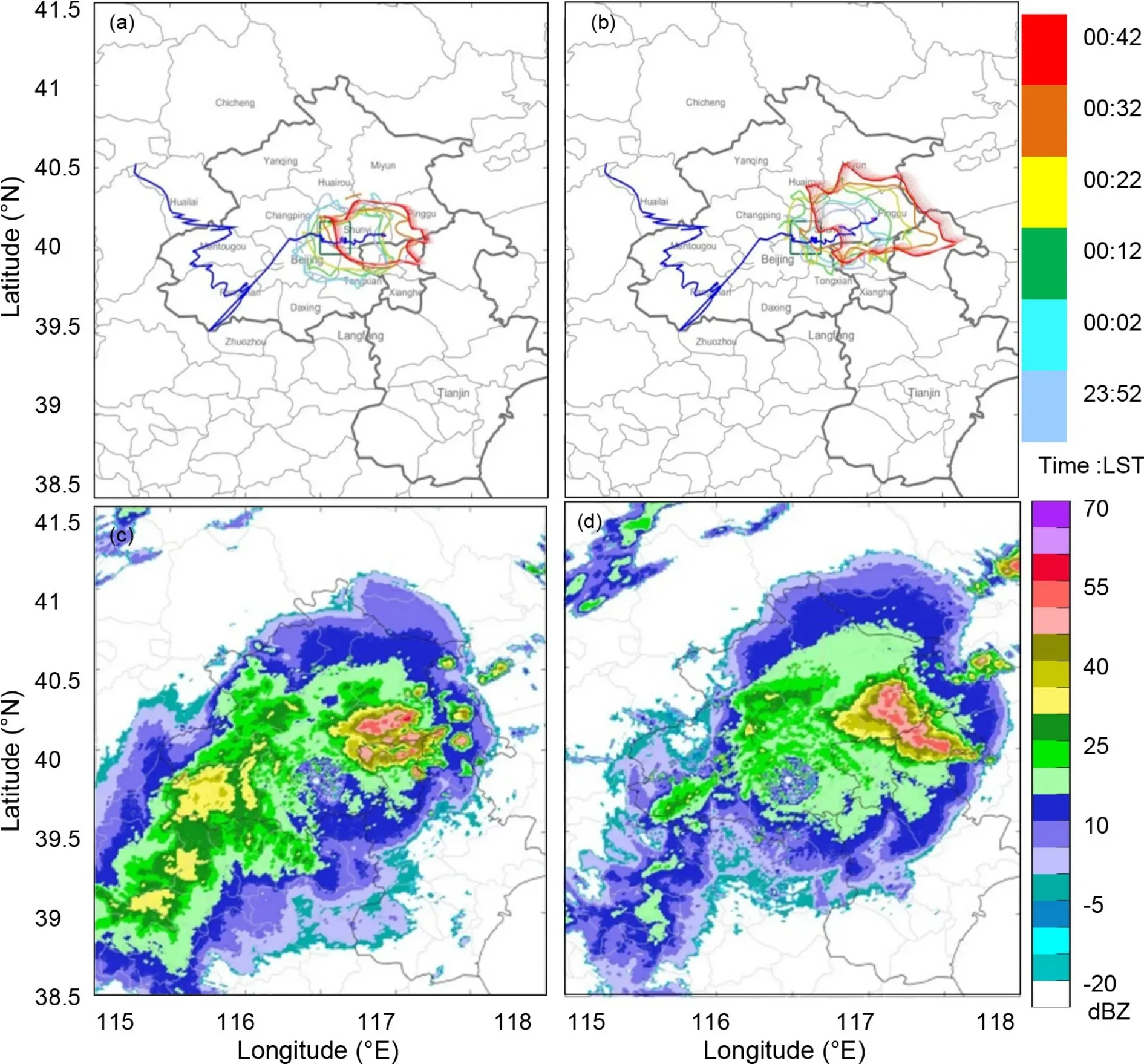
Fig. 6. The real-time prediction and warning on 14 July 2017. (a) The thunderstorm cell from lightning data at 0006 LST, (b)thunderstorm cell from lightning data at 0042 LST, (c) thunderstorm cell from radar echo at 0006 LST, (d) the thunderstorm cell from radar echo at 0042 LST.
4.3. Case 3
A thunderstorm, consisting of two isolated convective cells, occurred on 16 July 2018, which was different from the other two cases. One cell moved from southwest to northeast, and the other cell remained in almost at the same place and the nowcasting algorithm tested both of them. At 0304 LST two convective cells were identified as cell A near the AOC which was accompanied by significantly high lightning frequency, and cell B was far from the AOC (see Fig. 8a).According to the prediction, cell A, would reach the AOC after 30 minutes, as the faded red (forecasted polygons)cells overlapped with the AOC at 0304 LST. Later, the faded red polygon converted to dark red (identified polygon) and it started to overlap with the AOC in every twominute interval. This was a clear indication that the thunderstorm cell with active lightning activity was moving toward the AOC until 0332 LST. At 0334 LST, a few grids of the thunderstorm cell overlapped with the AOC, as shown in Fig. 8b. This is an example of a real-time prediction that successfully nowcasted the lightning activity over the AOC.The warning continued after the thunderstorm passed over the AOC.
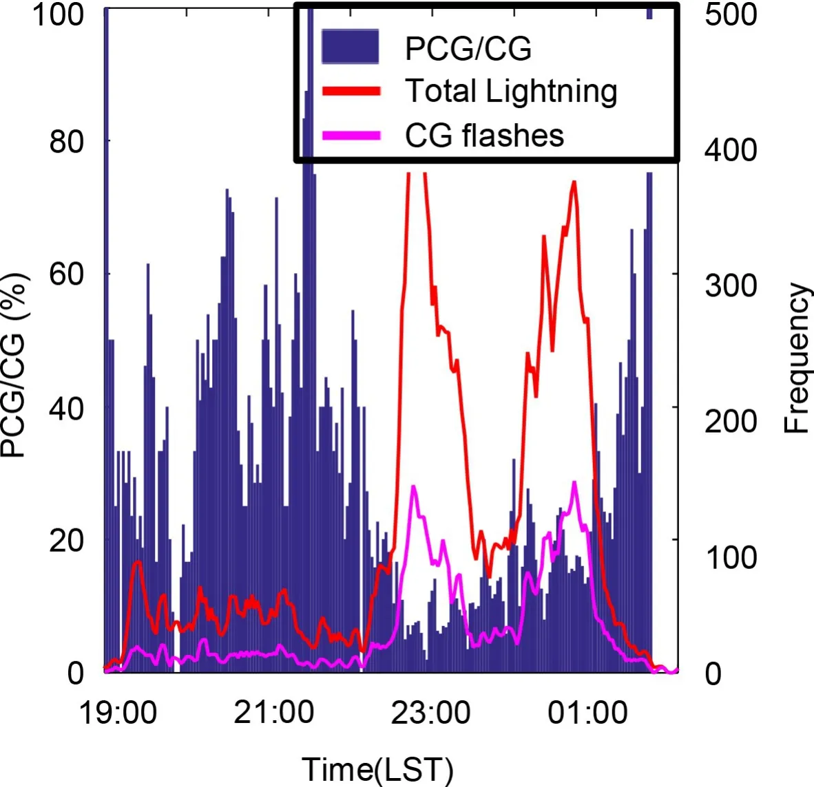
Fig. 7. The lightning flash rate on 13 July 2017. The left-hand axis shows the percentage of PCG/CG and the right-hand axis shows the number of flashes per two minutes.
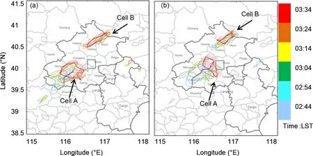
Fig. 8. The real-time prediction and warning on 16 July 2018. (a) The thunderstorm cells from lightning data at 0304 LST.(b) Thunderstorm cells from lightning data at 0334 LST with the direction towards cell A.
5. Discussions and conclusion
A lightning nowcasting technique is proposed by using a thunderstorm tracking algorithm and lightning location data over Beijing area. Neighborhood techniques are applied to BLNET lightning location data to identify the boundaries of the thunderstorm cells. By using lightning data, the proposed algorithm provides a thunderstorm warning on a designated AOC before the thunderstorm reaches the AOC. Although convective cells of thunderstorms could be predicted in this way, their complete shape or size could not, thus a similar shape of an observed cell is taken for forecasting purposes. Compared with the radar echo, the identified convective cells are shrinking more than the corresponding radar echo, and composite reflectivity larger than 45 dBZcorresponds to a lightning data cell. Moreover, the locations of thunderstorms are the same when detected through the use of either total lightning data or radar echo. As total lightning data identified thunderstorm cells, the algorithm presented in this work can be used as a lightning warning system. This result implies that the electrical behavior of thunderstorms is distributed from the convective core to the nearouter region of radar echos above 45 dBZin the Beijing area. In addition, the electrical behavior was negligible around or outside the outer region of the radar echo. It is well documented that the total lightning flash rate and electrification tend to rapidly increase and intensify within the deep convective region. Similar to our results, Makowski et al. (2013) reported that the total flash rate associated with deep convection was concentrated near the stronger reflectivity regions. Nevertheless, the few lightning occurrences that are located outside of the storm cores are not negligible, similar to the more dangerous + CG lightning flashes which frequently occur in the trailing stratiform region (Yuan et al.,2017). This work shows that the total lightning algorithm approach is sufficient for a quality alert system. The orographic terrain around Beijing can be an obstacle for radar signals, so the lightning data can fill this gap to some extent.
Although the radar scans thunderstorms every six minutes, the total lightning is measured instantaneously.This fact could provide sufficient data and provide for additional lead time. The total lightning could offer a sufficiently long lead time, especially for the rapid development of convection. Furthermore, combining radar with lightning data would be worthwhile. This method could be one of the future attempts to develop a thunderstorm tracking system and a warning system.
As, a thunderstorm may develop far away from the AOC, which may consist of communities, farms, airports, stadiums, residential areas, and other densely populated areas,it is beneficial to know the characteristics of the approaching thunderstorm in advance. The thunderstorm tracking and lightning forecasting over the AOC in actionable lead times are advantageous to the public interest. This algorithm can be used to track a thunderstorm, to forecast lightning,and to forecast severe weather occurrence (hail, high winds)in the AOC. Moreover, a different technique is needed to explicitly identify severe weather.
In summary, the algorithm developed in this study can track the thunderstorm path and generate a warning in a selected area with a sufficient lead time. The neighborhood technique was applied to obtain the boundaries, and smoothing was applied to improve the accuracy of these boundaries. In addition, the warning is more appropriate when the flash rate is higher. Fifty-seven thunderstorm days with 1159 cases were used for the thunderstorm tracking. The algorithm identification results revealed the entirety of the identified cell associated with the strong radar echo. The total lightning data was particularly valuable in giving a sufficiently long lead time. This algorithm provides a good result for forecasting the thunderstorms approaching 30 minutes earlier and it is highly effective for a five minute lead time before a thunderstorm arrived over an AOC.
Acknowledgements. The National Natural Science Foundation of China (Grant Nos. 41630425, 41761144074 and 41875007)supported the research. We are thankful to anonymous reviewers for their valuable suggestions to improve the quality of the manuscript. The first author also would like to thank the Chinese Academy of Sciences for the CAS-PIFI fellowship grant.
 Advances in Atmospheric Sciences2022年1期
- Advances in Atmospheric Sciences的其它文章
- FY-3E: The First Operational Meteorological Satellite Mission in an Early Morning Orbit
- Satellite All-sky Infrared Radiance Assimilation: Recent Progress and Future Perspectives
- Impacts of Oceanic Fronts and Eddies in the Kuroshio-Oyashio Extension Region on the Atmospheric General Circulation and Storm Track
- Ocean Response to a Climate Change Heat-Flux Perturbation in an Ocean Model and Its Corresponding Coupled Model
- Dissimilarity among Ocean Reanalyses in Equatorial Pacific Upper-Ocean Heat Content and Its Relationship with ENSO
- Comparison of the Anthropogenic Emission Inventory for CMIP6 Models with a Country-Level Inventory over China and the Simulations of the Aerosol Properties
