Dynamics of NDVI and its influencing factors in the Chinese Loess Plateau during 2002–2018
Peng He,Lishuai Xu,Zhengchun Liu,Yaodong Jing,Wenbo Zhu
College of Resources and Environment,Shanxi Agricultural University,Taigu,030801,China
ABSTRACT
Understanding the spatio-temporal changes of vegetation and its climatic control factors can provide an important theoretical basis for the protection and restoration of eco-environments.In this study,we analyzed the normalized difference vegetation index(NDVI)in the Chinese Loess Plateau(CLP)from 2002 to 2018 via trend analysis,stability analysis,and Mann-Kendall mutation test to investigate the change of vegetation.In addition,we also used the skewness analysis and correlation analysis to explore the contribution of climate change and human activities on regional vegetation changes.The results indicated that the overall increasing trend of NDVI from 2002 to 2018 was significant.The areas showing increased NDVI were mainly distributed in the southeastern CLP and the irrigation districts of the Yellow River to the north and west of the CLP,while the areas showing decreased NDVI were concentrated in the desert of the western Ordos Plateau,Longzhong Loess Plateau,and the built-up and adjacent areas.Precipitation was the dominant factor contributing to vegetation growth in the CLP,while vegetation was less dependent on precipitation in the irrigation districts.The increasement of NDVI has led to a prolonged response time of vegetation to water stress and a lag effect of less than two months in the CLP.The effect of temperature on NDVI was not significant;significant negative correlations between NDVI and temperature were found only in the desert,the Guanzhong Plain,the southern Liupan Mountains,and the southeastern Taihang Mountains,owing to high temperatures,urban heat islands,and large cloud cover in mountainous areas.Affected by the“Grain for Green Program”(GGP),NDVI in the CLP increased from 2002 to 2018;however,the increasing trends of NDVI for different vegetation cover types were significantly different owing to the difference in background status.The increasing contribution rate of NDVI in the CLP mainly came from crops and steppes.Urban not only led to the destruction of vegetation but also had radiation effect causing negative impact of NDVI around the cities.This resulted in the aggravation of the negative bias of NDVI with time in the CLP.The results provide a long-term perspective for regional vegetation protection and utilization in the CLP.
ARTICLEINFO
Keywords:
Chinese Loess Plateau
NDVI
Vegetation cover types
Temperature
Precipitation
Human activities
1.Introduction
The normalized difference vegetation index(NDVI)can accurately reflect metabolic intensity and annual variation in vegetation and indicate vegetation growth and changes in temperature,precipitation,and other climate factors in the absence of human activities and natural disasters(Piao et al.,2006;Wu et al.,2015).However,the ways in which climate factors drive NDVI and how it varies at different spatial and temporal scales are still debated. In arid and semi-arid areas, researchers studied the effects of precipitation changes on vegetation productivity and resilience based on the Global Inventory Modeling and Mapping Studies(GIMMS3g)NDVI,concluding that precipitation was the main influencing factor for vegetation(Liu et al.,2018).In Asia,the correlations of the seasonal variation of NDVI with temperature,precipitation,evapotranspiration,and other factors from 1982 to 2014 were calculated,concluding that temperature was the main influencing factor for variation in vegetation(Lamchin et al.,2018).Moreover,findings of studies on the relationship between vegetation and climate factors in the Chinese Loess Plateau(CLP)were significantly different.Due to the implementation of Grain for Green Program(GGP),NDVI increased significantly in the CLP from 2001 to 2010,and the spatial distributions of correlations between NDVI and precipitation and between NDVI and temperature were significantly different(Sun et al.,2015).Based on the Syst′eme Pour Observation Terre Vegetation(SPOT VGT)NDVI from 1999 to 2013,NDVI was not significantly correlated with precipitation and temperature on the seasonal,growing season,or annual time scale,while it was significantly positively correlated with monthly precipitation(Zhang et al.,2016).These studies indicated that the response of NDVI to climate was complex,and the reasons might be attributed to the application of different research scales(Zhang et al.,2020a,b),human activities(Zheng et al.,2019),or the heterogeneity of the landscape environments(Zhou et al.,2020).Thus,studying the differences in response of NDVI to variations in climate and human activities is important.
The CLP is well known for its intensive soil erosion and fragile ecological environment;it is a key area for ecological civilization construction in China(Gao et al.,2020;Shi et al.,2020).The GGP was launched to convert agricultural land located on steep slopes to forests and grasslands in the CLP,and remarkable progresses have been achieved(Lu et al.,2012;Xiao,2014).According to the statistical data,improved vegetation in the CLP accounted for 67.08% of the total area,and the vegetation cover has increased by more than 50.00%(Gao et al.,2017).However,studies have shown that thermal and moisture conditions in the CLP are critical because of the unique geological and topographic conditions,and the influence of global climate change and human activities(Zhang et al.,2020a,b).Whether vegetation can maintain its current status or show degradation is widely disputed(Feng et al.,2016).Thus,studying the real-time evolution of NDVI and its response to climate change and human activities in the CLP is of great significance for predicting dynamic vegetation changes.
Many scholars have found that NDVI showed an overall increasing trend from 1981 to 2016 in the CLP(Xin et al.,2007;Wang et al.,2011);NDVI in the southeast was larger than that in the northwest,and NDVI in the northwest of Gobi desert had an insignificant reduction trend(Li et al.,2016;Sun et al.,2020).The increasement of NDVI in forestland and grassland was the most significant,while the areas showing a decreased NDVI were concentrated in cultivated land(Deng et al.,2017;Li et al.,2017).However,there were significant differences in conclusions with regards to NDVI variation trend at different time stages,owing to the use of different data sources and analysis methods(Dong et al.,2020).Moreover,there are few studies on the variation trends of NDVI of improved vegetation cover types,and the variation trend of NDVI in the CLP after 2016.
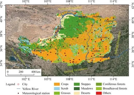
Fig.1.Location of Chinese Loess Plateau(CLP)and spatial patterns of main vegetation cover types.
In this study,we analyzed NDVI in the CLP by trend analysis,stability analysis,and Mann-Kendall mutation test(M-K test),and explored the impacts of climate and human activities on the variation of vegetation in the CLP.Thus,the objectives of this study were to(1)analyze the spatial distribution characteristics and temporal variation trends of NDVI in the CLP from 2002 to 2018;(2)compare correlations between NDVI and precipitation and between NDVI and temperature;(3)study the effects of human activities on NDVI;and(4)explain the reasons behind the different relationships.
2.Materials and methods
2.1.Study area
The CLP(33°41′–41°16′N,100°52′–114°33′E)is located in the east of the Riyue Mountains,west of the Taihang Mountains,north of the Qinling Mountains,and south of the Yinshan Mountains.It consists of one province(Shanxi Province),one autonomous region(Ningxia Hui Autonomous Region),and portions of five provinces and autonomous regions,namely Shaanxi Province,Henan Province,Inner Mongolia Autonomous Region,Gansu Province,and Qinghai Province(Fig.1).The CLP occupies 6.4×10⁵km2of land in the middle reaches of the Yellow River,and extends approximately 1000 km from east to west and 750 km from north to south(Yu et al.,2020).The CLP is characterized by a temperate continental monsoon climate with mean annual temperature ranging from 9°C to 12°C,and annual precipitation ranging from 100 to 800 mm(Li et al.,2010;Guo et al.,2011).The spatial difference in mean annual temperature and annual precipitation is significant,decreasing from southeast to northwest.Mean annual temperature increased by 1.2°C,and annual precipitation decreased by 29.1 mm in the CLP from 1961 to 2010,which indicates an obvious fluctuation in climate over time(Wang et al.,2012).The main vegetation cover types in the CLP include crops,steppes,scrub,broadleaved forests,deserts,meadows,grasses,and coniferous forests.Drought and soil erosion are the main challenges in the CLP,resulting the CLP as the most fragile ecological environment in the world(Zhang and Liu,2005).
2.2.Data sources
MOD09A1(spatial resolution 500 m)is formatted in Hierarchical Data Format-Earth Observing System(HDF-EOS)with a Sinusoidal projection(https://ladsweb.modaps.eosdis.nasa.gov). The CLP is represented by the H26V05,H27V05,H27V06,and H28V06 tiles.The projection was redefined into the Universal Transverse Mercator(UTM).We used the maximum value composite(MVC)to process NDVI calculated by the near red and red bands,to eliminate the interference of clouds,atmosphere,and solar height angle and to obtain monthly NDVI from 2002 to 2018 and further synthesize annual NDVI.
The monthly precipitation and temperature data from 2002 to 2018 for Shanxi,Henan,Shaanxi,Gansu,Qinghai,Ningxia,and Inner Mongolia were obtained from the China Meteorological Data Service Centre(https://www.nmic.cn), and the annual precipitation and mean annual temperature were calculated.The monthly precipitation and temperature data with a spatial resolution of 500 m from 2002 to 2018 were calculated by inverse distance weighted interpolation and ordinary kriging interpolation,respectively,through resampling and clipping.Annual precipitation and mean annual temperature with a spatial resolution of 500 m were synthesized.
The vegetation cover data of the CLP obtained from the atlas of vegetation in China provided by the Resource and Environmental Data Cloud Platform(http://www.resdc.cn),were classified into nine categories,including crops,steppes,scrub,broadleaved forest,deserts,meadows,grasses,coniferous forests,and others(0.5%).The built-up areas of Xi’an City,Taiyuan City,Luoyang City,Yinchuan City,Lanzhou City,Baotou City,Hohhot City,Xining City,Datong City,and Linfen City extracted from the MCD12Q1 were used to analyze the impacts of urban size on NDVI.
2.3.Methods
2.3.1.Trend analysis
The NDVI trends in the CLP were calculated using slope value.The essence of slope is that unary linear opportunity is used to simulate the changing trend of each grid,and the temporal changing characteristics of a single pixel are used to reflect the changing of the whole space(Koju et al.,2020).The formula is as follows:

where Slope represents the slope of NDVI regression equation; n is the span of years; i is the time series; and NDVIiis NDVI value at time i.A positive slope value indicates the increase of NDVI,whereas a negative slope value indicates the decrease of NDVI.
2.3.2.Stability analysis
The coefficient of variation(CV)can be used to describe the relative fluctuation in geographical data.Thus,we adopted the CV to reflect the stability of NDVI change.The formula is as follows:

where CV is the coefficient of variation of NDVI;n is the span of years;i is the time series;xiis NDVI value at time i;anddenotes the average NDVI during the study period.A higher CV value indicates a large fluctuation in the time series and a lower CV value indicates a small fluctuation in the time series.
2.3.3.Mann-Kendall mutation test(M-K test)
The M-K test is a nonparametric statistical test that is used to evaluate the significance of changes in a time series.The advantage of the M-K test is that the method does not require a specific sample distribution and is free from interference from outliers.The M-K test has been widely used to elucidate trends in hydrological,climatic,and environmental factors(Ma et al.,2019).The formulas are as follows:

where Xiand Xjrepresent NDVI values at times i and j,respectively.Skis the cumulative number when Xi>Xj.E(Sk)and Var(Sk)are the mean and variance of Sk.UFk>0 indicates that the sequence of NDVI has an upward trend,and UFk<0 indicates that the sequence of NDVI has a downward trend.Repeat the process in reverse order of the time series(Xk,Xk–1,…,X1)and UBkis set to –UFk.UF and UB represent critical values at the 5% significance level(±1.96).The intersection point of UFkand UBkis the beginning time of mutation.If the intersection point is between the UF and UB,the mutation reaches a significant level.
3.Results
3.1.Spatial distribution characteristics of the normalized difference vegetation index(NDVI)
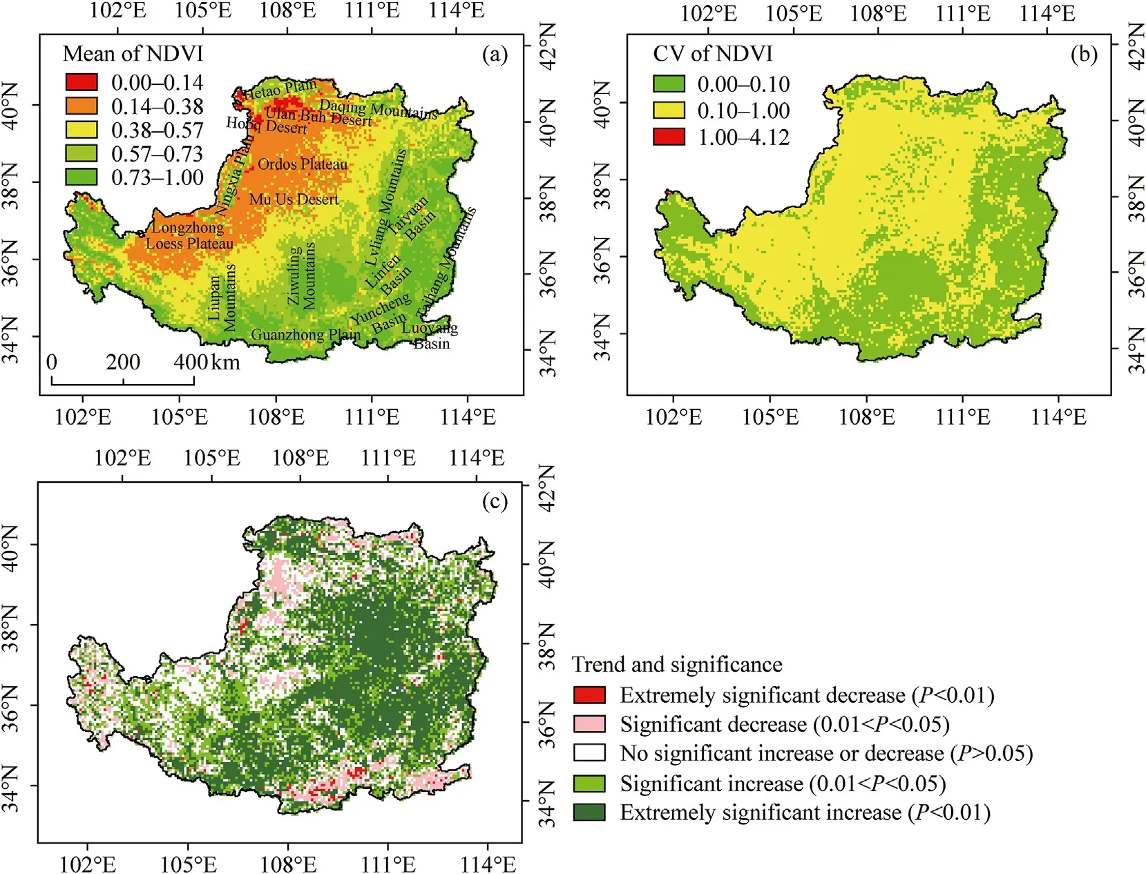
Fig.2.Spatial distribution characteristics of mean normalized difference vegetation index(NDVI)(a),coefficient of variation(CV)of NDVI(b),and trend and significance of NDVI(c)in the CLP from 2002 to 2018.
Fig.2a shows the mean NDVI in the CLP from 2002 to 2018,which increased from northwest to southeast.The NDVI was generally lower than 0.38 in the northwest of the CLP and between 0.14 and 0.38 in the Ordos Plateau,Mu Us Desert,northern Ningxia,and regions near the Tengger Desert. The NDVI in the Hobq and Ulan Buh deserts was lower than 0.14, where vegetation cover types weredeserts and steppes with bare ground and low vegetation coverage. The NDVI in the Hetao Plain, Daqing Mountains, and Ningxia Plainwas high, including the irrigation districts of the Yellow River and the areas with multiple water systems. The region with NDVI between0.38 and 0.57 was from Northwest Shanxi to Dingxi in Gansu, where vegetation cover types were crops, steppes, and some scrubs,meadows, and grasses, and NDVI reached to 0.57 in the southeast of the region. The NDVI was the highest in the eastern and southernCLP at more than 0.73. There are many mountains in the eastern and southern CLP, such as Lvliang, Taihang, Ziwuling, Qinling, andLiupanshan mountains, which are also important nature reserves. However, NDVI was relatively low (between 0.14 and 0.57) in thedensely populated areas (Guanzhong Plain, Luoyang, Taiyuan, Linfen, and Yuncheng).
As shown in Fig.2b,areas with the weak variation(0.00–0.10)and moderate variation(0.10–1.00)in NDVI accounted for 44.92% and 55.07% of total area in the CLP,respectively,while strong variation(>1.00)only accounted for 0.01%.Compared with Fig.2a,the weak variation in NDVI was distributed in the areas with NDVI higher than 0.73,while the moderate variation was mainly distributed in the areas with NDVI lower than 0.57.
To further analyze the spatial variation of NDVI in the CLP,we established five categories of NDVI:extremely significant increase,significant increase,no significant increase or decrease,significant decrease,and extremely significant decrease(Fig.2c).The NDVI decreased extremely significantly when the slope was negative and P value was lower than 0.01.The NDVI decreased significantly when the slope was negative and P value was lower than 0.05 but higher than 0.01. The NDVI increased extremely significantly when the slope was positive and P value was lower than 0.01.The NDVI increased significantly when the slope was positive and P value was lower than 0.05 but higher than 0.01.The P value higher than 0.05 was considered as no significant increase or decrease in NDVI.The NDVI of the CLP showed an increasing trend from 2002 to 2018,and the proportion with an increasing trend was 64.72%.The areas where NDVI increased extremely significantly and increased significantly occupied 24.85% and 39.87%,respectively.The increasement of NDVI was mainly distributed in the southeastern CLP and irrigation districts of the Yellow River in the northern and western parts of the CLP,where vegetation cover types were crops,scrubs,grasses,and broadleaved forests.The proportion with a decreasing trend of NDVI was 11.83%,and the areas where NDVI decreased extremely significantly and decreased significantly occupied 1.04% and 10.79%,respectively.The decrease of NDVI occupied mainly in the densely populated areas,and NDVI decreased significantly in the desert of the western Ordos Plateau and the Longzhong Loess Plateau,due to poor natural conditions.
3.2.Time series variation in NDVI
As shown in Fig.3,skewness and kurtosis of NDVI from 2002 to 2018 were calculated to analyze the time variation trend of NDVI in the CLP.The distribution of NDVI in the CLP was negatively skewed and was between-0.6 and-0.1.The absolute value of skewness increased from 2002 to 2018,which indicated that the bias degree of NDVI tending to the low value range increased and the bias degree of NDVI tending to the high value range decreased,while the high NDVI number increased.This implied that NDVI showed an increasing trend in the CLP overall,but the decrease degree of NDVI in decreasing areas was higher than the increase degree of NDVI in increasing areas.Kurtosis of NDVI was between-1.0 and-0.6,which indicated that the concentration degree of NDVI in the CLP was lower than the normal distribution,and the high value interval of NDVI occupied a large proportion in the CLP,combined with the skewness coefficient.This was consistent with the results shown in Fig.2a.
As shown in Fig.4,NDVI in the CLP showed a short-term decreasing trend from 2002 to 2006,an increasing trend from 2006 to 2010,and a significant increasing trend from 2010 to 2018.The NDVI in crops and coniferous forests showed a short-term increasing trend from 2002 to 2006,which was not significant.After 2006,the UFkwas higher than 1.96,indicating that NDVI began to increase significantly with no abrupt change.The NDVI in scrub and broadleaved forests showed a non-significant short-term decreasing trend from 2002 to 2004,and a significant increasing trend with no abrupt change from 2006 to 2018.The NDVI in meadows and grasses showed a decreasing trend from 2002 to 2004, an increasing trend after 2004, and further a significantly increasing trend with no abruptchange after 2009 and 2007, respectively. The NDVI in steppes and deserts decreased non-significantly from 2002 to 2006, respectivelyincreased from 2008 to 2013 and from 2010 to 2015, and respectively increased significantly from 2013 to 2018 and from 2015 to 2018.The abrupt change in NDVI in steppes and deserts occurred in 2010 and 2011,respectively.
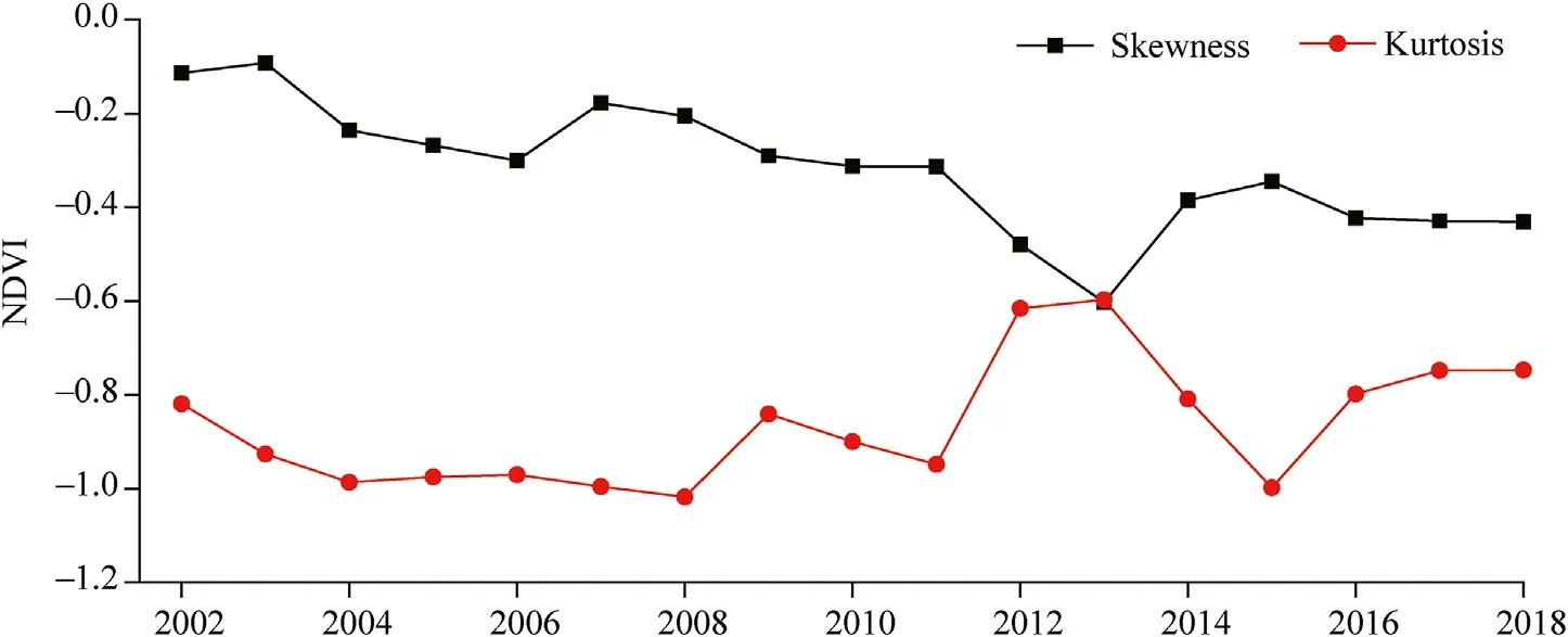
Fig.3.Skewness and kurtosis of NDVI in the CLP from 2002 to 2018.
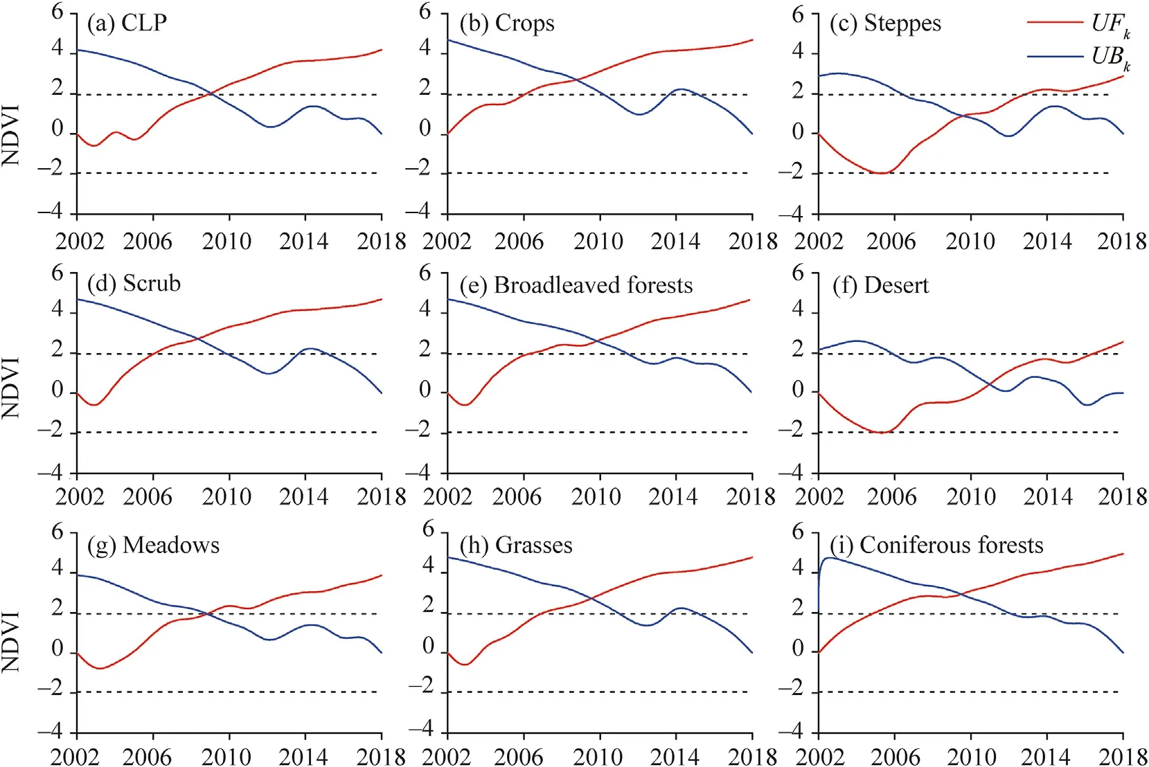
Fig.4.Mann-Kendall mutation test of NDVI in the CLP(a),as well as in different vegetation cover types(crops(b),steppes(c),scrub(d),broadleaved forests(e),desert(f),meadows(g),grasses(h),and coniferous forests(i))from 2002 to 2018.The black dotted line represents the critical value at the 5% significance level(±1.96).UFkand UBkrepresent forward sample sequence statistics and reverse sample sequence statistics,respectively.
3.3.Correlations of NDVI with temperature and precipitation
The correlation coefficient between NDVI and temperature and the correlation coefficients between NDVI delayed from one to three months and temperature were calculated(Fig.5).The correlation between NDVI delayed from one to three months and temperature wasnot significant, indicating that the response of NDVI in the CLP to temperature was not delayed. Moreover, the proportion of the areawith a non-significant correlation between NDVI and temperature was 93.43% in the CLP. The proportion of the area with a significantnegative correlation between NDVI and temperature was 6.57% in the CLP, and was mainly located in the Hobq Desert, Ulan Buh Desert,the desert in the northern Ordos Plateau, Guanzhong Plain, southern Liupan Mountains, and southeastern Taihang Mountains.
The correlation coefficients between NDVI and precipitation were also calculated(Fig.6).There was a significant positive correlation between NDVI and precipitation,accounting for 90.12% of the study area.Areas with non-significant correlation between NDVI and precipitation accounted for 9.88% of the study area;these areas were mainly concentrated in the irrigation districts of the Yellow River in the Ningxia Plain,including irrigation districts in the Tumochuan Plain,the Datong River,and the Weihe River.The positive correlations between NDVI delayed one month and precipitation and between NDVI delayed two months and precipitation were still strong,accounting for 88.07% and 81.26% of the area in the CLP,respectively.The positive correlation between NDVI delayed three months and precipitation decreased significantly,but the significant positive correlation remained in some areas,especially the main channel of the Yellow River.In general,the correlation between NDVI and precipitation was stronger than the correlation between NDVI and temperature.
As shown in Fig.7,the mean and median NDVI in the CLP showed a significant increasing trend,with increase rates of 0.0057/a and 0.0077/a,respectively.There was no significant increase or decrease in temperature and precipitation from 2002 to 2018,except for 2003 and 2013,and the correlation coefficients between the mean NDVI and temperature and between the mean NDVI and precipitation were 0.035 and 0.501,respectively,which failed the significance test.This indicated that the correlations of annual NDVI with annual temperature and precipitation were not significant.However,NDVI corresponding to the maximum precipitation in 2013 was also the maximum;precipitation increased since 2011,while NDVI entered a period of high fluctuation from 2012 to 2018.This further indicated that NDVI in the CLP was influenced more by precipitation than by temperature.
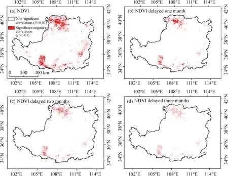
Fig.5.Spatial patterns of the correlations between NDVI and temperature(a),between NDVI delayed one month and temperature(b),between NDVI delayed two months and temperature(c),and between NDVI delayed three months and temperature(d)in the CLP.
4.Discussion
4.1.Effects of temperature and precipitation on NDVI
Temperature and precipitation are widely regarded as the main factors affecting vegetation pattern changes in the CLP(Li and Zhang,2003).Temperature is not the limiting main factor of vegetation growth in the CLP;however,the increasing temperature accelerated the process of surface evapotranspiration,which indirectly leads to a lack of soil moisture and the development of a dried soil layer.This exhibits an obvious inhibitory effect on vegetation growth(Liu et al.,2020).Thus,we conclude that the correlation between NDVI and temperature is only a reflection of vegetation change in the CLP(Xin et al.,2007).This finding differs from a previous conclusion by Zhang et al.(2016)that the average NDVI is negatively correlated with temperature at a monthly scale in the CLP,which may be due to the differences in study periods and spatial scales.There is less vegetation cover and little precipitation in the Hobq Desert,Ulan Buh Desert,and the desert in the northern Ordos Plateau.High temperature will accelerate evaporation and further inhibit NDVI(Zhuang et al.,2020).The Guanzhong Plain in the southern CLP is the most densely populated area.High temperatures and the urban heat island effect will inhibit vegetation growth,leading to a significant negative correlation between NDVI and temperature(Chakraborty et al.,2020).In the southern Liupan Mountains and southeastern Taihang Mountains,high precipitation and high elevation lead to the high cloud cover,compared with other surrounding areas.This,in turn,leads to a reduction in solar radiation reception and weakening of vegetation photosynthesis(Timilsena et al.,2009).Meanwhile,the enhancement of ground radiation leads to an increase in temperature,which results in a negative correlation between NDVI and temperature.
Because the CLP is located in arid and semi-arid regions,where precipitation is the main limiting factor for NDVI(Xin et al.,2007);there is a significant positive correlation between NDVI and precipitation in the CLP.Due to irrigation,the vegetation was less dependent on precipitation in the irrigation districts,which led to the insensitivity of vegetation response to precipitation(Yu and Shang,2017).The lag time of vegetation response to climate change is consistent with the time of the biogeochemical cycle,and precipitation affects vegetation growth by affecting moisture availability.The lagging response of vegetation to precipitation reflects the time interval between precipitation and precipitation reaching plant roots and affecting plant growth(Wu et al.,2019).Compared with the conclusions of Xin et al.(2009)and Zhang et al.(2016),the response of NDVI to precipitation in the CLP had a lag effect of one month before 2013;the increasement of NDVI improves the ability of the soil to hold moisture(Wang et al.,2003;Cui et al.,2009),which leads to a prolonged response time of vegetation to water stress and a lag effect of less than two months after 2013. The humid and warm local climate formed near the main channel of the Yellow River can improve the problem caused by the lack of precipitation during the vegetative growth period(Cao et al.,2007),which leads to a significant positive correlation between NDVI delayed three months and precipitation.
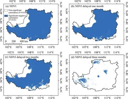
Fig.6.Spatial patterns of the correlations between NDVI and precipitation(a),between NDVI delayed one month and precipitation(b),between NDVI delayed two months and precipitation(c),and between NDVI delayed three months and precipitation(d)in the CLP.

Fig.7.Changes of mean and median NDVI(a)and mean temperature and precipitation(b)in the CLP from 2002 to 2018.
4.2.Effects of underlying surfaces on NDVI
The CLP spans a vast area and includes diverse vegetation cover types.Owing to the difference in plant physiological characteristics,variations in NDVI among different vegetation cover types with time are different,indicating that the background status of vegetation in the CLP determines the time series change of NDVI(Javed et al.,2020).As shown in Table 1,there was a significant positive correlation between NDVI in different vegetation cover types and time series,and the maximum increasing rate was for grasses(0.007/a),followed by crops,steppes,scrub,broadleaved forest,deserts,and coniferous forests.The minimum increasing rate was for meadows(0.003/a).The increasing contribution rates of different vegetation cover types in the CLP were calculated by weighting the increasing rate of different vegetation cover types according to the area ratio,which showed that the increasing contribution rates were distributed from large to small in the order of crops>steppes>scrub>grasses>broadleaved forests>deserts>meadows>coniferous forests>others.The increasing contribution rate of crops and steppes exceeded 74.00%.A large area of crops was converted to grasslands and forests from 2002 to 2006,affected by the GGP aimed at alleviating soil erosion and improving the ecological environment.The NDVI in crops increased insignificantly at this stage and was affected by the original underlying surface(Fan et al.,2015).The GGP was aimed at creating forest areas through scaled afforestation,leading to an obvious ecological effect during the consolidation stages since 2006,namely a weakening of NDVI variability and volatility in the time series,due to the increase in NDVI.Moreover,the regional vegetation conditions under the influence of the GGP improved significantly,which produced a positive role for different vegetation cover types in adjacent areas and resulted in a significant increase in NDVI after 2006.The NDVI in steppes was low and vulnerable to external environmental influences,making it difficult to recover.The degradation of permafrost in the northwestern CLP has led to the decrease of soil moisture and the aggravation of grassland destruction before 2008(Sun et al.,2015).After 2018,the quantity of vegetation and vegetation coverage in the steppes increased due to the influence of the GGP.The regional climate characteristics of steppes are low temperature,low humidity,and long sunshine hours, which affect precipitation response(Jun et al.,2009).Precipitation in the CLP after 2010 showed a modest increase compared with that in the previous years,which resulted in a transformation of NDVI in steppes,and NDVI in steppes increased significantly after 2013.

Table 1Linear regression between NDVI and time series for different vegetation cover types.
The extent of variation trends of NDVI in buffer zones of 0–1, 1–3, 3–5, 5–7, and 7–10 km outside the built-up areas of Xi’an, Taiyuan,Luoyang, Yinchuan, Lanzhou, Baotou, Hohhot, Xining, Datong, and Linfen were calculated (Fig. 8). The results indicated that thevariation trend in NDVI was considerably affected by the built-up areas; specifically, the extent of the decreasing trend of NDVI declinedwhen the distance to a built-up area increased. Both Xi’an and Luoyang are located in a plain and are closely connected to adjacent cities,resulting in a large proportion of the decreasing trend of NDVI falling within the buffer zones of 7–10 km outside the built-up areas. Theextent of the decreasing trend of NDVI in buffer zones of 7–10 km outside the built-up areas in other cities was less than 40%. Affected byterrain, the built-up areas of Taiyuan, Datong, Linfen, and Lanzhou developed only in the north–south or east–west direction, whiledevelopment in other directions was restricted, which resulted in the impact of the built-up areas on NDVI being mitigated, and a highproportion of the increasing trends in NDVI occurring in buffer zones of 0–1 km outside the built-up areas. Affected by the accelerationin urbanization and industrialization, the urban built-up areas and adjacent areas still negatively impact the ecological environment.Moreover, for cities that not affected by terrain, the larger the city size, the greater the decline of NDVI, indicating that the negativeimpact on NDVI was stronger when the urban size was larger. The decreasing trend of NDVI in buffer zones of 3–5 km outside the built up areas was still dominant, implying that urban expansion not only changed the land cover types, but also had a radiation effect causinga negative impact on NDVI around the cities. This further indicates that the destruction of vegetation caused by urban has a far greaterimpact than that of direct occupation, despite urban expansion being limited ((Al-husban, 2019)). This is also the reason why the biasdegree of NDVI tends to be low in the CLP.
5.Conclusions
Precipitation is the main limiting factor for vegetation growth in the CLP.The overall NDVI in the CLP increased from 2002 to 2018,which leads to a prolonged response time of vegetation to precipitation.The correlation between NDVI and temperature is only a reflection of vegetation change.The demand of different vegetation types for water and heat conditions is different.Thus,vegetation restoration should be carried out by rational utilization of water and heat resources according to local conditions.
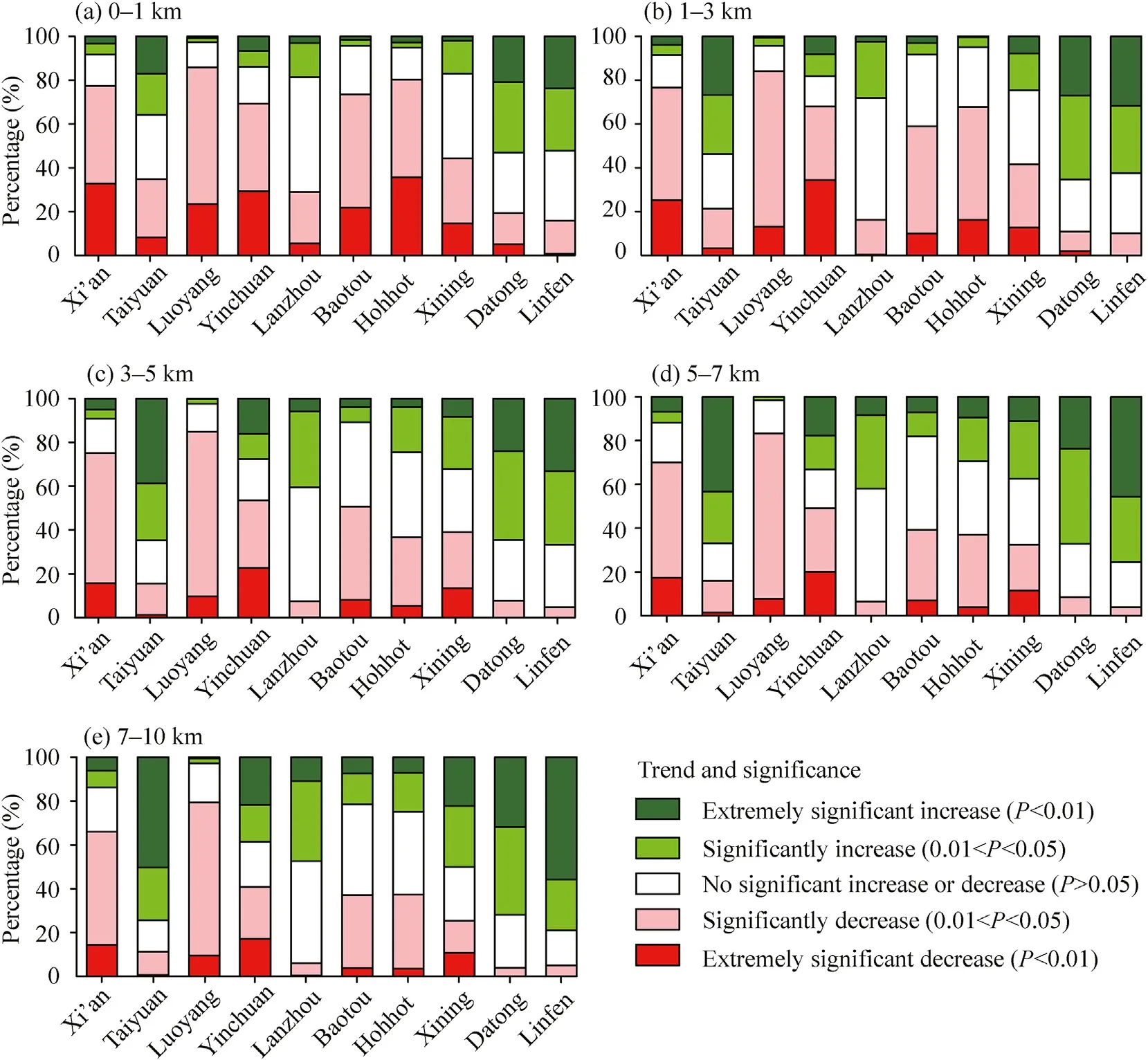
Fig.8.Extent of variation trends of NDVI in buffer zones of 0–1 km(a),1–3 km(b),3–5 km(c),5–7 km(d),and 7–10 km(e)outside the built-up areas of Xi’an,Taiyuan,Luoyang,Yinchuan,Lanzhou,Baotou,Hohhot,Xining,Datong,and Linfen cities.
Under the influence of the GGP,NDVI of different vegetation types showed significant differences in increasing contribution rate.The increasing contribution rate to NDVI in the CLP mainly came from crops and steppes.The negative impact on NDVI was significant when the urban size was large due to the radiation effect,and the impact of vegetation destruction caused by urban was far greater than that caused by direct occupation.We should pay more attention to the vegetation degradation caused by urban radiation effects in the future.
Declaration of competing interest
The authors declare that they have no known competing financial interests or personal relationships that could have appeared to influence the work reported in this paper.
Acknowledgements
This work was jointly supported by the Natural Science Foundation for Young Scientists of Shanxi Province of China(201801D221043),and the Science and Technology Innovation Fund of Shanxi Agricultural University(2016YJ16,2017022).We thank Ms.Huifei Han for her assistance in interpreting the significance of the result of this study.
- 区域可持续发展(英文)的其它文章
- Purchase willingness of new energy vehicles:A case study in Jinan City of China
- Assessing the adequacy and sustainability performance of multi-family residential buildings in Anambra State,Nigeria
- Impact of high-speed railway construction on spatial relationships in the Guanzhong Plain urban agglomeration
- Effect of future climate change on the water footprint of major crops in southern Tajikistan
- Exploration of the dynamic water resource carrying capacity of the Keriya River Basin on the southern margin of the Taklimakan Desert,China
- Spatial pattern and drivers of urbanization in China’s mid-level developing urban agglomeration:A case study of Chang-Zhu-Tan

