基于Sentinel多源数据的农田地表土壤水分反演模型构建与验证
郭 交,刘 健,宁纪锋,韩文霆
基于Sentinel多源数据的农田地表土壤水分反演模型构建与验证
郭 交1,2,刘 健1,2,宁纪锋3,韩文霆4
(1.西北农林科技大学机械与电子工程学院,杨凌 712100;2. 陕西省农业信息感知与智能服务重点实验室,杨凌 712100;3. 西北农林科技大学信息工程学院,杨凌 712100;4. 西北农林科技大学水土保持研究所,杨凌 712100)
土壤水分是影响水文、生态和气候等环境过程的重要参数,而微波遥感是农田地表土壤水分测量的重要手段之一。针对微波遥感反演农田地表土壤水分受植被覆盖影响较大的问题,该文基于Sentinel-1和Sentinel-2多源遥感数据,利用Oh模型、支持向量回归(support vector regression,SVR)和广义神经网络(generalized regression neural Network,GRNN)模型对土壤水分进行定量反演,以减小植被影响,提高反演精度。结果表明:通过水云模型去除植被影响后的Oh模型反演精度有所提高。加入不同植被指数的SVR和GRNN模型的反演效果总体优于Oh模型,基于SVR模型的多特征参数组合(双极化雷达后向散射系数、海拔高度、局部入射角、修改型土壤调整植被指数)反演效果最优,其测试集相关系数和均方根误差分别达到了0.903和0.015 cm3/cm3,为利用多源遥感数据反演农田地表土壤水分提供了参考。
土壤水分;模型;遥感;反演;多源数据;Sentinel
0 引 言
土壤水分是地球生态系统中非常重要的组成部分,在全球水循环中发挥着积极作用[1],其直接影响着地表和大气界面的水分和能量交换,在全球气候变化和水循环的研究中扮演着重要的角色[2-3]。在农业应用中,土壤水分监测在农作物长势监测、作物估产和变量灌溉等应用中具有重要意义[4-5]。
在现有土壤水分监测方法中,合成孔径雷达(synthetic aperture radar,SAR)遥感是一种常用方式,其具有全天时、全天候工作的优势,适合定量反演农田地表土壤水分。为了反演土壤水分,需要建立雷达后向散射系数与介电常数之间的关系,而土壤的介电常数与土壤水分之间存在密切的联系[6-9]。何连等[10]利用多时相Sentinel-1雷达数据,实现了农田地表土壤水分的反演,验证结果表明土壤水分反演结果精度较好。尹楠等[11]基于RADARSAT-2全极化数据,通过修正Oh模型对研究区的土壤水分进行反演,验证表明预测结果较好。虽然利用雷达数据可以有效地反演裸土水分,但农田中土壤表层常有植被覆盖,所以在实际中单纯利用雷达数据有着极大的局限性。为克服这一缺点,张钧泳等[12]以Sentinel-1雷达数据和Landsat-8光学数据为数据源,利用水云模型去除植被影响后反演了土壤表层水分以及地下水埋深;蔡庆空等[13]利用RADARSAT-2雷达数据和Landsat-8光学数据基于水云模型去除植被影响后反演了农田土壤水分,为大面积反演土壤水分提供了研究思路。
虽然理论上利用水云模型可去除植被影响,但对不同植被类型,该模型参数需重新计算,模型的普适性不足。所以有学者直接通过植被指数来考虑植被覆盖影响,如Holtgrave等[14]利用Landsat-8数据计算归一化植被指数NDVI补偿植被对SAR的反向散射影响,基于SVR模型反演洪涝区的土壤水分,取得了较好的结果。虽然NDVI可以有效减小植被覆盖影响,但缺乏与其它植被指数的对比分析。另外,Landsat-8卫星的空间分辨率为30 m,重访周期为16天[15],其分辨率和重访周期无法满足及时准确的监测需求。而Sentinel-2的空间分辨率为10 m,重访周期为5天,且Sentinel-1与Sentinel-2同属于欧空局的Sentinel系列卫星(以下简称S1、S2),在空间、时间和数据配准方面,更适合监测土壤水分。
本文基于S1和S2多源遥感数据,以陕西省杨凌示范区周边农田区域为研究区,针对Oh模型利用S1雷达数据反演土壤水分受植被覆盖影响较大的问题,通过S2光学遥感数据计算植被指数,分别利用传统的水云模型、SVR和GRNN模型减小植被覆盖对土壤水分反演精度的影响,并在此基础上分析了不同特征参数组合下SVR和GRNN模型反演土壤水分的精度,为应用雷达和光学多源数据反演土壤水分提供研究思路,本文具体技术路线如图1所示。
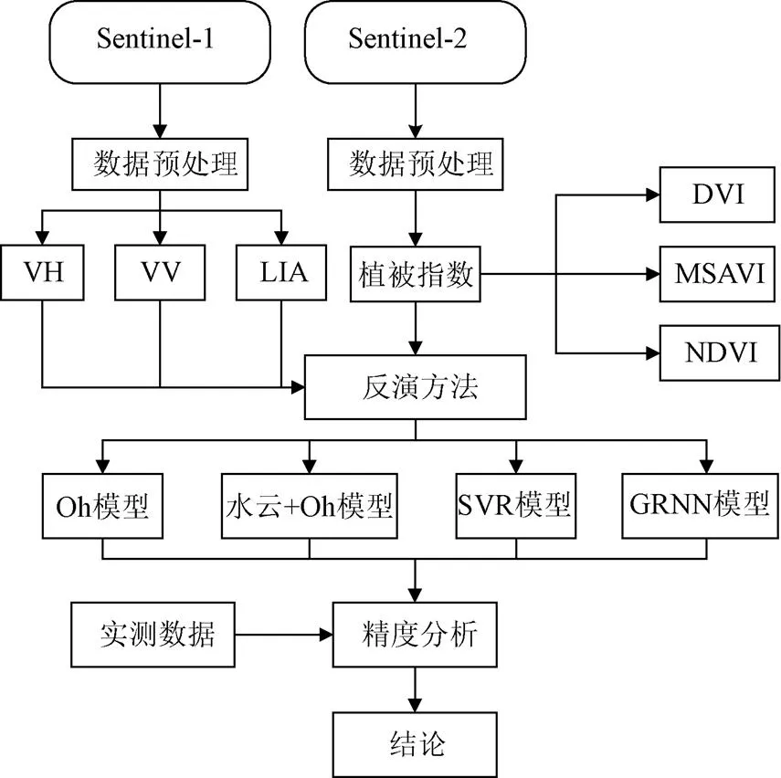
图1 技术路线图
1 研究区与数据源
1.1 研究区概况
研究区为陕西省杨凌示范区周边,该区域土壤肥沃,位于107°55′20″E-108°15′40″E,34°15′15″N-34°50′28″N,地势相对比较平坦,北部较南部略高,海拔高度介于560~790 m之间,属于东亚暖温带半湿润半干旱气候,具有春暖多风,夏热多雨、冬寒干燥等明显的大陆性季风气候特征,年均气温约12 ℃,无霜期211天,年均日照时数约2163 h,年均降水量635 mm。研究区主要作物为冬小麦,数据采集时小麦处于生长初期。
研究区面积为20 km×20 km,地面数据采集时间为2018年3月12日,S1卫星当天从研究区过境,S2卫星于2018年3月10日过境,以保证实测时间与卫星过境时间尽量一致。在研究区选取45个点作为采样点,实地采集土壤水分值、土壤粗糙度、经纬度坐标等地面参数,采样点分布如图2a所示。土壤水分利用TDR300型土壤水分计进行测量,测量时采用的探针长度为7.5 cm,用于获取表层土壤的体积含水量。在以采样点为中心半径5 m的范围内布置5个测量点,测量点呈“+”字形分布,每个测量点测5次。每个采样点的土壤水分是5个测量点的平均值。土壤粗糙度采用针式粗糙度仪进行测量,剖面板长度为1 m,相邻探针间隔1 cm,测量时沿同一方向连续测量5次,构成5 m的剖面用于求取粗糙度。采样点的经纬度坐标通过双频GPS(global positioning system)接收机进行定位测量,测量精度为厘米级,远小于遥感影像分辨率。
1.2 数据源及预处理


图2 遥感影像及采样点分布
2 研究方法
2.1 Oh模型分析


式中为入射角,rad;m为土壤体积含水量,cm3/cm3;为均方根高度,cm;为自由空间波数(=2p/,为频率,为波速),cm-1。尽管理论上Oh模型的适用范围较宽,但实际上,对粗糙或干燥的土壤,Oh模型的适用性并不好[11]。
对本文研究区地表参数的实测数据分析发现,土壤体积含水量实测值分布在0.081~0.284 cm3/cm3,平均值为0.182 cm3/cm3;均方根高度的实测值为0.452~1.453 cm,平均值为0.862 cm,均处于模型适用范围。因此,Oh模型适用于本研究区。
2.2 水云模型分析
Oh模型适用于反演裸土水分,但在实际应用中,通过雷达图像提取的后向散射系数中包含土壤表层植被的影响,直接利用Oh模型反演精度较低,故有学者通过水云模型分离植被的后向散射系数,以提高反演精度[20-22]。水云模型如式(4)-(6)所示


本研究区的植被类型主要为冬小麦,根据文献[23],式(5)、(6)中和分别取0.0018和0.138。植被含水量VWC是水云模型的重要输入参数,本文利用与S1过境时间相近的S2光学数据来计算NDVI。根据NDVI和VWC的关系[24-25],VWC可表示如下:


2.3 SVR模型分析
SVR就是支持向量机(support vector machine,SVM)在函数拟合上的应用,其基于VC维的统计理论和最小化结构风险理论,可以利用有限的样本数量选择合适的核函数实现高维空间的线性回归,根据泛函数的相关理论,当核函数(x,)满足Mercer定理时,对应的预测函数为[26]。


在本文的土壤水分反演中,利用SVR构建模型主要步骤如下:(1)构建数据集,输入特征参数包括双极化雷达后向散射系数、海拔高度和局部入射角以及3种植被指数(NDVI、MSAVI、DVI);(2)划分训练集和测试集,本文选择36个样本作为模型的训练集,9个样本作为模型的测试集;(3)SVR模型的核函数选择高斯径向基函数,通过网格参数寻优法确定惩罚因子和参数;(4)模型预测效果通过测试集的均方根误差和相关系数来评价。
2.4 GRNN模型分析
广义神经网络(GRNN)是一种以径向基函数为核函数的一种局部逼近网络,研究表明该网络对小样本预测有一定优势[27]。该网络由输入层、模式层、求和层和输出层构成,网络输入为各特征参数,网络输出为土壤水分预测值。GRNN的基本原理是非线性回归分析[28],其预测函数可表示为:

式中为训练样本数,为光滑因子,()是所有样本观测值的加权平均值,每个观测值y的权重因子通过对应样本x和网络输入的欧氏距离平方确定。在土壤水分反演过程中,GRNN构建模型时通过交叉验证法确定光滑因子,其它步骤和SVR模型构建过程相同。
3 结果与分析
3.1 Oh模型反演结果分析
利用水云模型去除植被影响前后Oh模型的反演结果验证如图3所示。从图3a和3b中可以看出,去除植被影响前测试集相关系数R和均方根误差RMSE分别为0.628和0.028 cm3/cm3,利用水云模型去除植被影响后测试集2和RMSE分别为0.650和0.025 cm3/cm3。利用水云模型去除植被影响后,2提高了0.022,RMSE减小了0.003 cm3/cm3,可知去除植被影响后反演的效果更好。
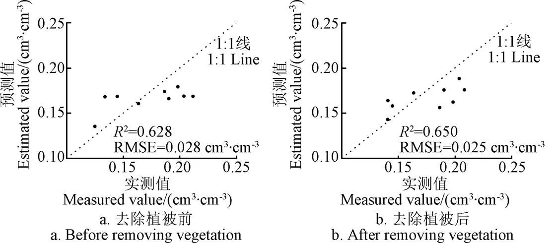
图3 去除植被影响前后Oh模型反演结果验证
3.2 SVR反演结果分析
对比4a、4d、4g,4b、4e、4h,4c、4f、4i这3组结果可以看出,基于3种植被指数NDVI、MSAVI和DVI的反演结果中MSAVI和NDVI的2均大于DVI,RMSE均小于DVI。由此可知,SVR模型反演土壤水分时,3种植被指数中DVI与土壤水分的相关性最弱。
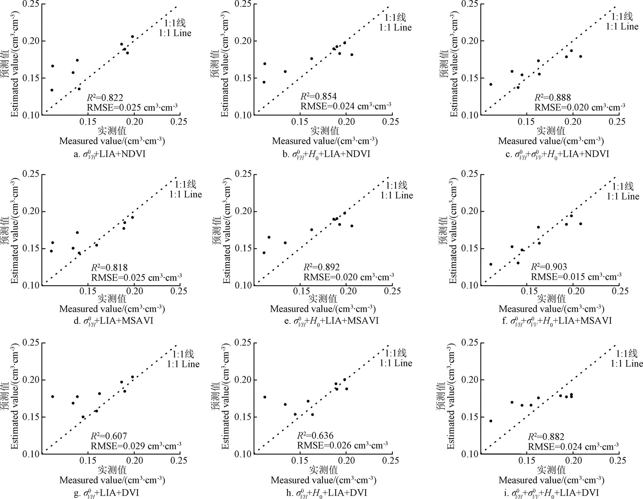
图4 基于不同特征参数组合的SVR模型土壤水分反演结果验证
3.3 GRNN反演结果分析
对比5a、5d、5g,5b、5e、5h,5c、5f、5i这3组结果可以看出,基于3种植被指数NDVI、MSAVI和DVI的反演结果中MSAVI和NDVI的2均大于DVI,RMSE均小于DVI。由此可知,GRNN模型反演土壤水分时,3种植被指数中DVI与土壤水分的相关性最弱。
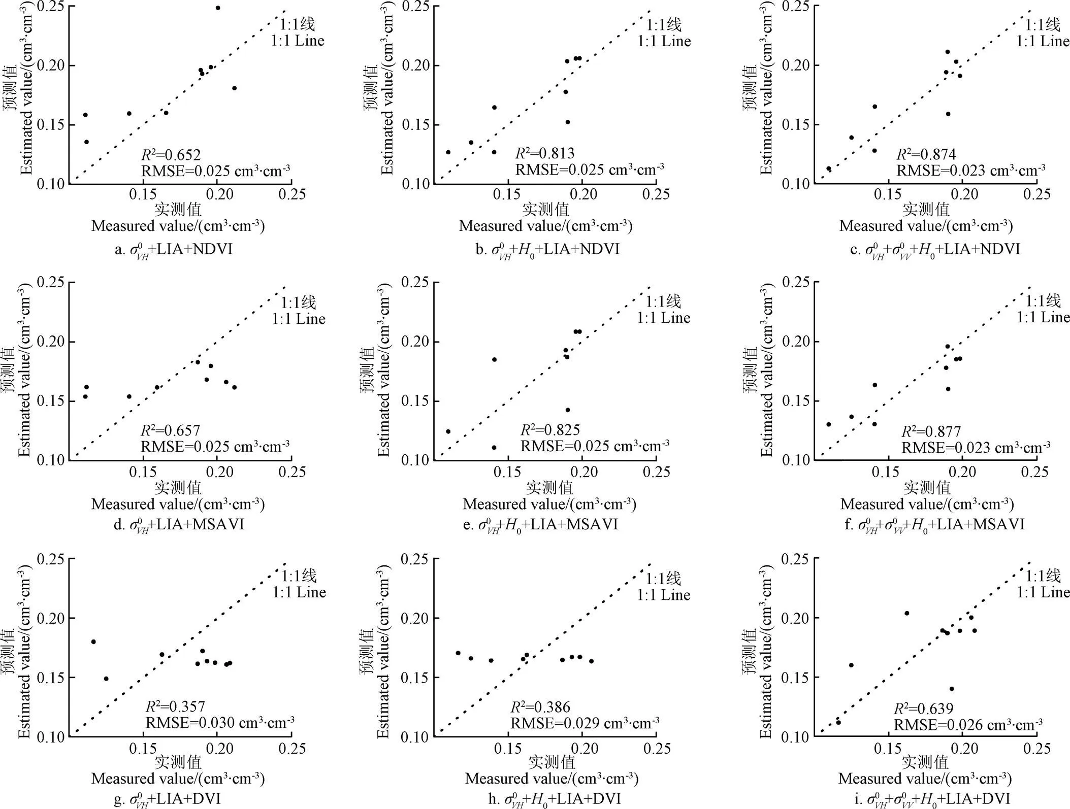
图5 基于不同特征参数组合的GRNN模型土壤水分反演结果验证

利用前文所构建的SVR最优模型和3个时相的数据对整个试验区进行土壤水分反演,结果如图6所示。2月28日土壤水分反演结果整体较高,试验区土壤水分均值为0.307 cm3/cm3,这是由于在卫星过境前两日试验区有持续降雨,所以土壤比较湿润。3月12日反演的试验区土壤水分均值为0.245 cm3/cm3,卫星过境前试验区域仅有少量降雨,故土壤水分值相比于2月28日略有降低。3月24日反演的土壤水分值最低,均值为0.186 cm3/cm3,这是因为前一周天气晴朗无降雨过程。由此可知,3个时间的土壤水分反演结果与降雨情况比较吻合,该模型在试验区具有较强的适用性。
3.4 特征参数重要性分析


图6 试验区不同时期地表土壤水分反演结果
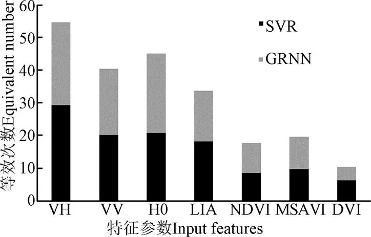
图7 特征参数等效出现次数

4 结 论
本文利用S1和S2多源遥感数据作为数据源进行土壤水分定量反演,通过水云模型去除植被影响,利用Oh模型、SVR和GRNN模型反演土壤水分,探讨了雷达后向散射系数、海拔高度、局部入射角、3种植被指数等参数对土壤水分反演精度的影响,主要结论包括:
1)对于Oh模型而言,通过水云模型去除植被影响后其反演效果更好;对于SVR和GRNN模型而言,植被指数为MSAVI和NDVI时反演效果优于Oh模型。基于SVR模型的最佳组合测试集2和RMSE分别为0.903和0.015 cm3/cm3,相比于GRNN最优组合,SVR最优组合的2提高了0.026,RMSE减小了0.008 cm3/cm3,相比于去除植被影响后Oh模型的反演结果,SVR最优组合的2提高了0.253,RMSE减小了0.010 cm3/cm3。
2)通过分析各特征参数对土壤水分反演结果的影响,验证了雷达后向散射系数、海拔高度、局部入射角、植被指数对农田地表土壤水分反演的重要影响,同时发现3种植被指数对土壤水分的相关性由大到小为:MSAVI、NDVI、DVI。
本研究区的植被类型主要为冬小麦,后续的研究中将进一步探讨模型在其它农田地表类型的适用性。S1雷达与S2光学卫星同属欧空局的Sentinel系列卫星,在多源影像配准和融合方面具有较大优势,在农田土壤水分反演等应用中具有巨大潜力。
[1] Anagnostopoulos V, Petropoulos G P, Ireland G, et al. A modernized version of a 1D soil vegetation atmosphere transfer model for improving its future use in land surface interactions studies[J]. Environmental Modelling and Software, 2017, 90: 147-156.
[2] Leng Pei, Song Xiaoning, Duan Sibo, et al. A practical algorithm for estimating surface soil moisture using combined optical and thermal infrared data[J]. International Journal of Applied Earth Observation and Geoinformation, 2016, 52: 338-348.
[3] Rahimzadeh-Bajgiran P, Berg A A, Champagne C, et al. Estimation of soil moisture using optical/thermal infrared remote sensing in the Canadian Prairies[J]. ISPRS Journal of Photogrammetry and Remote Sensing, 2013, 83(3): 94-103.
[4] Wang Hongquan, Magagi R, Goita K. Potential of a two-component polarimetric decomposition at C-band for soil moisture retrieval over agricultural fields[J]. Remote Sensing of Environment, 2018, 217: 38-51.
[5] Stamenkovic J, Guerriero L, Ferrazzoli P, et al. Soil moisture estimation by SAR in alpine fields using Gaussian Process Regressor trained by model simulations[J]. IEEE Transactions on Geoscience and Remote Sensing, 2017, 55(9): 4899-4912.
[6] Nelson D G A, Shariati M, Glena R, et al. Application of the Dubois-model using experimental synthetic aperture radar data for the determination of soil moisture and surface roughness[J]. ISPRS Journal of Photogrammetry and Remote Sensing, 1999, 54(4): 273-278.
[7] Hosseini M, Mcnairn H. Using multi-polarization C- and L-band synthetic aperture radar to estimate biomass and soil moisture of wheat fields[J]. International Journal of Applied Earth Observation and Geoinformation, 2017, 58: 50-64.
[8] Xu Xiaoyong, Tolson B A, Li J, et al. Comparison of X-band and L-Band soil moisture retrievals for land data assimilation[J]. IEEE Journal of Selected Topics in Applied Earth Observations and Remote Sensing, 2017, 10(9): 3850-3860.
[9] Pasolli L, Notarnicola C, Bruzzone L. Estimating soil moisture with the Support Vector Regression technique[J]. IEEE Geoscience and Remote Sensing Letters, 2011, 8(6): 1080-1084.
[10] 何连,秦其明,任华忠,等. 利用多时相Sentinel-1 SAR数据反演农田地表土壤水分[J]. 农业工程学报,2016,32(3):142-148.
He Lian, Qin Qiming, Ren Huazhong, et al. Soil moisture retrieval using multi-temporal Sentinel-1 SAR data in agricultural areas[J]. Transactions of the Chinese Society of Agricultural Engineering (Transactions of the CSAE), 2016, 32(3): 142-148. (in Chinese with English abstract)
[11] 尹楠,姜琦刚,孟治国,等. 基于RADARSAT-2全极化数据反演周期性地表土壤湿度[J]. 农业工程学报,2013,29(17):72-79.
Yin Nan, Jiang Qigang, Meng Zhiguo, et al. Use of fully polarimetric RADARSAT-2 data to retrieve soil moisture of periodic surfaces[J]. Transactions of the Chinese Society of Agricultural Engineering (Transactions of the CSAE), 2013, 29(17): 72-79. (in Chinese with English abstract)
[12] 张钧泳,丁建丽,谭娇. 基于SVM 的绿洲荒漠交错带土壤水分与浅层地下水埋深反演[J]. 农业机械学报,2019,50(3):221-230.
Zhang Junyong, Ding Jianli, Tan Jiao. Quatitative estimation of soil moisture and shallow groundwater level using SVM in arid oasis-desert[J]. Transactions of the Chinese Society for Agricultural Machinery, 2019, 50(3): 221-230. (in Chinese with English abstract)
[13] 蔡庆空,李二俊,陶亮亮,等. PROSAIL 模型和水云模型耦合反演农田土壤水分[J]. 农业工程学报,2018,34(20):117-123.
Cai Qingkong, Li Erjun, Tao Liangliang, et al. Farmland soil moisture retrieval using PROSAIL and water cloud model[J]. Transactions of the Chinese Society of Agricultural Engineering (Transactions of the CSAE), 2018, 34(20): 117-123. (in Chinese with English abstract)
[14] Holtgrave A K, Foerster M, Greifeneder F, et al. Estimation of soil moisture in vegetation-covered floodplains with Sentinel-1 SAR data using Support Vector Regression[J]. PFG-Journal of Photogrammetry, Remote Sensing and Geoinformation Science, 2018, 86(2): 85-101.
[15] Bao Yansong, Lin Libin, Wu Shanyu, et al. Surface soil moisture retrievals over partially vegetated areas from the synergy of Sentinel-1 and Landsat 8 data using a modified water-cloud model[J]. International Journal of Applied Earth Observation and Geoinformation, 2018, 72: 76-85.
[16] Lee J S, Grunes M R, Grandi G De. Polarimetric SAR speckle filtering and its implication for classification[J]. IEEE Transactions on Geoscience and Remote Sensing, 1999, 37(5): 2363-2373
[17] Oh Y, Sarabandi K, Ulaby F T. An empirical model and an inversion technique for radar scattering from bare soil surface[J]. IEEE Transaction on Geoscience and Remote Sensing, 1992, 30(2): 370-381.
[18] Oh Y, Sarabandi K, Ulaby F T. Semi-empirical model of the ensemble averaged differential Mueller matrix for microwave backscattering from bare soil surfaces[J]. IEEE Transactions on Geoscience and Remote Sensing, 2002, 40(6): 1348-1355.
[19] Oh Y. Quantitative retrieval of soil moisture content and surface roughness from multipolarized radar observations of bare soil surfaces[J]. IEEE Transactions on Geoscience and Remote Sensing, 2004, 42(3): 596-601.
[20] Emilie B, FranOis W, FranOis C, et al. Maize leaf area index retrieval from synthetic quad Pol SAR time series using the water cloud model[J]. Remote Sensing, 2015, 7(12): 16204-16225.
[21] Kumar K, Suryanarayana Rao H P, Arora M K. Study of water cloud model vegetation descriptors in estimating soil moisture in Solani catchment[J]. Hydrological Processes, 2015, 29(9): 2137-2148.
[22] Liu Chenzhou, Shi Jiancheng. Estimation of vegetation parameters of water cloud model for global soil moisture retrieval using time-series L-band aquarius observations[J]. IEEE Journal of Selected Topics in Applied Earth Observations and Remote Sensing, 2016, 9(12): 5621-5633.
[23] Bindlish R, Barros A P. Parameterization of vegetation backscatter in radar-based, soil moisture estimation[J]. Remote Sensing of Environment, 2001, 76(1): 130-137.
[24] Jackson T J, Vine D M L, Hsu A Y, et al. Soil moisture mapping at regional scales using microwave radiometry: the Southern Great Plains Hydrology Experiment[J]. IEEE Transactions on Geoscience and Remote Sensing, 1999, 37(5): 2136-2151.
[25] Kong Jinling, Yang Jing, Zhen Peipei, et al. A coupling model for soil moisture retrieval in sparse vegetation covered areas based on microwave and optical remote sensing data[J]. IEEE Transactions on Geoscience and Remote Sensing, 2018, 56(12): 7162-7173.
[26] Brereton R G, Lloyd G R. Support Vector Machines for classification and regression[J]. Analyst, 2010, 135(2): 230-267.
[27] Li Weide, Yang Xuan, Li Hao, et al. Hybrid forecasting approach based on GRNN neural network and SVR machine for electricity demand forecasting[J]. Energies, 2017, 10: 44.
[28] Naguib R N G, Hamdy F C. A general regression neural network analysis of prognostic markers in prostate cancer[J]. Neurocomputing, 1998, 19: 145-150.
Construction and validation of soil moisture retrieval model in farmland based on Sentinel multi-source data
Guo Jiao1,2, Liu Jian1,2, Ning Jifeng3, Han Wenting4
(1.712100; 2.712100,;3.712100,4.712100,)
As an important component of the earth ecosystem, soil moisture is of great significance in the fields of crop growth monitoring, crop yield estimation, variable irrigation and other related agricultural applications. With the rapid development of the technology and theory of microwave remote sensing, soil moisture retrieval with remote sensing data has been widely used at home and abroad.The multi-source remote sensing data used in this study was acquired from Sentinel-1 radar and Sentinel-2 optical satellites which belong to ESA's Sentinel series and there are great advantages in space, time and data registration in monitoring soil moisture. The study area is located in Yangling Demonstration Zone, Shanxi Province and 45 sampling sites were selected and measured to validate the soil moisture retrieval model. Firstly, to deal with the problem that soil moisture retrieval was greatly affected by surface vegetation covers, this study applied Oh model to retrieve soil moisture after removing the influence of vegetation by water cloud model. Secondly, taking the great advantages of machine learning algorithms into account, the study selected support vector regression (SVR) and generalized regression neural network (GRNN) models to retrieve soil moisture, and the models were constructed with different combinations of characteristic parameters including VH polarization radar backward scattering coefficient and VV polarization radar backward scattering coefficient altitude (0), local incident angle (LIA) which were calculated out with Sentinel-1 radar remote sensing data and vegetation indexes (normalized difference vegetation index, NDVI; modified soil adjusted vegetation index, MSAVI and difference vegetation index, DVI) which were calculated out with Sentinel-2 optical remote sensing data. Finally, this study defined the equivalent number of occurrences to evaluate the quantitative influence of each characteristic parameter because different parameters had different effect on farmland soil moisture retrieval. The results showed that the soil moisture retrieval accuracy of Oh model was increased after removing vegetation influence by water cloud model. The retrieval accuracies of SVR and GRNN models with MSAVI and NDVI were higher than that of Oh model. The optimal input combination of SVR model composed of five characteristic parameters, including VH polarization radar backward scattering coefficient, VV polarization radar backward scattering coefficient,0, LIA, and MSAVI had the best retrieval accuracy with correlation coefficient of 0.903 and root mean square error of 0.014cm3/cm3respectively. The optimal SVR model was used to retrieve the soil moisture in study area and the results were consistent with local rainfall events. The equivalent numbers of occurrences of characteristic parameters from high to low were VH polarization radar backward scattering coefficient,0, VV polarization radar backward scattering coefficient, LIA, MSAVI, NDVI, DVI. For radar backward scattering coefficients from different polarized channel, VH polarization radar backward scattering coefficient is more sensitive to soil moisture than VV polarization radar backward scattering coefficient. Among the three vegetation indexes, the counting results indicated MSAVI had the strongest correlation with soil moisture content, followed by NDVI and DVI was the weakest. The experimental results showed that the fusion of radar and optical data had great potential in soil moisture retrieval in farmlands. The performances of the constructed model in other farmland types would be further investigated in the future.
soil moisture; models; remote sensing; retrieval; multi-source data; Sentinel
2019-01-23
2019-06-30
国家自然科学基金资助项目(41301450)、“十三五”国家重点研发计划课题(2017YFC0403203)、杨凌示范区产学研用协同创新重大项目(2018CXY-23)和中央高校基本科研业务费专项资金资助项目(2452019180)
郭 交,副教授,博士,研究方向为农业遥感和精准农业。Email:jiao.g@163.com
10.11975/j.issn.1002-6819.2019.14.009
S24
A
1002-6819(2019)-14-0071-08
郭 交,刘 健,宁纪锋,韩文霆. 基于Sentinel多源数据的农田地表土壤水分反演模型构建与验证[J]. 农业工程学报,2019,35(14):71-78. doi:10.11975/j.issn.1002-6819.2019.14.009 http://www.tcsae.org
Guo Jiao, Liu Jian, Ning Jifeng, Han Wenting. Construction and validation of soil moisture retrieval model in farmland based on Sentinel multi-source data[J]. Transactions of the Chinese Society of Agricultural Engineering (Transactions of the CSAE), 2019, 35(14): 71-78. (in Chinese with English abstract) doi:10.11975/j.issn.1002-6819.2019.14.009 http://www.tcsae.org

