
The Preliminary Research and Analysis of Ecological Environment Construction in the Small River Basin
2019-09-10 07:22:44HaifanWANGYuanjunXU
农业生物技术(英文版) 2019年6期
Haifan WANG Yuanjun XU
Abstract Through nearly seven months of investigation and research, detailed information and data on vegetation resources, land resources and other ecological resources in the Taojia small river basin were obtained, and the data were analyzed and processed. The results show that due to the destruction of forest vegetation, the steep slope reclamation and water channel leakage in the Taojia small river basin, well fields and forest land at multiple sites in the basin have been buried by mud and rock, and abundant forest vegetation distributed in the middle and upper reaches has reduced to the situation of a forest coverage rate of only 15.5%. As a result, a vicious circle of "ecological destruction, soil erosion, farmland reduction, poverty, steep slope cultivation, ecological destruction" has been formed. Based on the analysis of the basic ecological background of the basin, six ecological restoration proposals such as planting soil and water conservation forests and fruit trees and blockading protection were proposed, in order to provide support for restoring the ecological environment of the basin and achieving sustainable development of the ecological environment within the basin.
Key words Dongchuan, Yunnan; River basin; Ecological resources; Soil erosion; Sustainable development
Received date: May 27, 2019Accepted: August 29, 2019
Supported by National Technology R&D Program (0BAC06B02).
Haifan Wang (1987-), male, assistant docent, master, mainly engaged in teaching and studying of forestry.
*Corresponding author. Email: haifanwang@hotmail.com.
The small river basin is a comprehensive natural regional system with natural water supply as the main link, closely connected with natural support systems such as vegetation coverage, land use, water cycle and ecosystem. As an important measure in the strategic deployment of Chinas western development, the ecological environment construction of the small river basin has always been an important part of Chinas sustainable development strategy[1]. After longterm research and summary by researchers, the destruction of ecological environment is divided into two categories: first, the occurrence of soil erosion, which has been aggravated by increasing human activities, which is due to the rapid growth of Chinas population, and second, seriously damaged forests, which are because of the extensive resource development of steelmaking, the "threeline construction" and the change of forest rights after land contracting.
In this study, taking the Taojia small river basin in Dongchuan District of Yunnan Province as an example, the "3S" technology was used to conduct a comprehensive survey of the basin during the period from February to August 2013, and the current situation of land use, the status of soil erosion, the status of ecological environment and social and economic conditions in the basin were systematically analyzed based on the 1∶10 000 topographic map and soil census data. According to the ecological environment of the Taojia small river basin and the needs of economic, social and ecological construction, on the basis of the guiding ideology of "prevention first, integrated planning, comprehensive control, adjusting measures to local conditions, giving prominence to the key points and embodying benefits" and "combining water and soil erosion control and ecological resources development and utilization", the measures and suggestions for the ecological construction of the basin were discussed, with a view to providing support for restoring the ecological environment of the basin and realizing the sustainable development of the ecological environment within the basin, and also providing reference for the ecological restoration of small watersheds with similar ecological environment in China.
General Situation of the Research Area
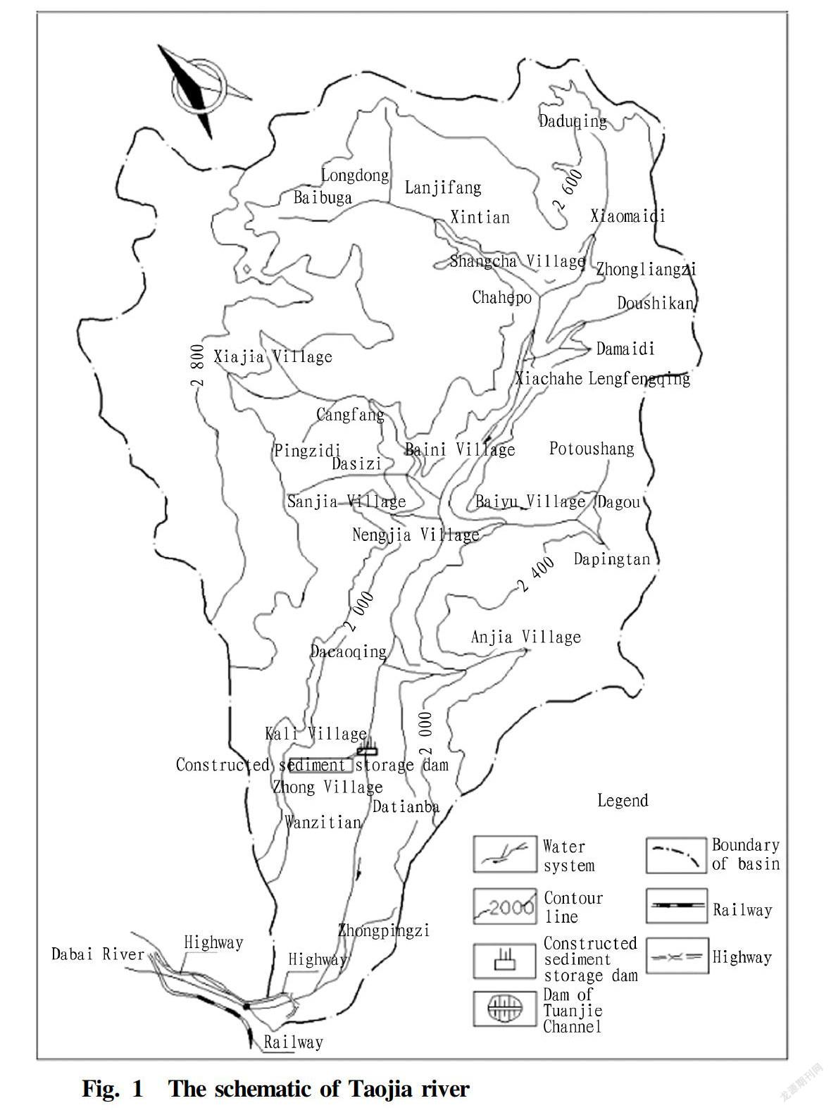
The Taojia small river basin is located in the southern part of Dongchuan District, Yunnan Province, with a longitude of 103°14′24″-103°21′36″ and a latitude of 25°57′22″-26°01′35″. The Taojia small river basin covers an area of 7 116 hm2, and the main channel is 16.6 km long. It originated from the Jiache Village, Huize County, Yunnan Province. It belongs to the Xiaojiang water basin of the Jinsha River water system and flows from the east to the west into the Dabai River, a tributary of the eastern Xiaojiang River[2]. Goukou is about 20 km away from Dongchuan City, and the highway from Kunming to Dongchuan passes through Goukou. The railway branch line from Kunming to Dongchuan passes through the west bank of the intersection of Taojia small river and Dabai River. The Dongchuan District farmland irrigation lifeline project, i.e., the intake dam of Tuanjie Channel, is located on the main channel of the Dabai River, 300 m north of Goukou (Fig. 1).
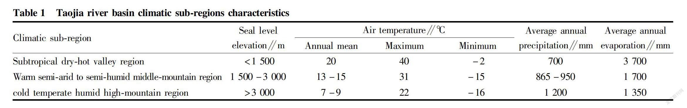
The basin belongs to the subtropical monsoon climate zone. Due to the influences of atmospheric circulation, solar radiation and topography, it has the characteristics of obvious vertical zoning climate, distinct dry and wet seasons and strong local heavy rainfall. With the increase of altitude, the temperature, precipita
tion, evaporation and humidity in the basin are obviously changed, and the region can be divided into three climate subregions: the subtropical dryhot valley region, warm semiarid to semihumid middlemountain region and cold temperate humid highmountain region. The characteristics of various subregions are shown in Table 1. The dry and wet seasons in the basin are obvious. The rainy season is from May to October every year, during which the precipitation accounts for 88% of the total annual precipitation; the precipitation from June to August is more concentrated, and the multisite heavy rain accounts for more than 50% of the annual precipitation; and the dry season is from November to April of the following year, during which the precipitation is only 12% of the total annual precipitation.
Background Analysis of the Ecological Environment
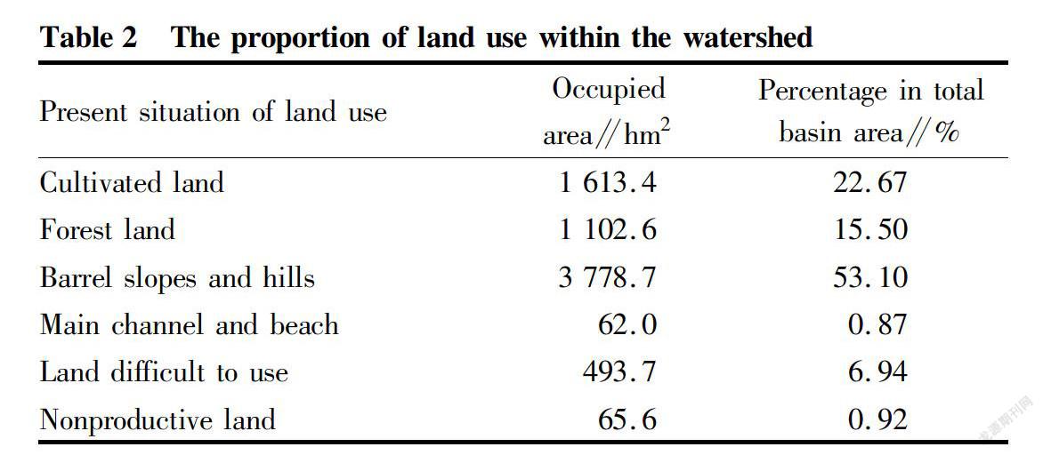
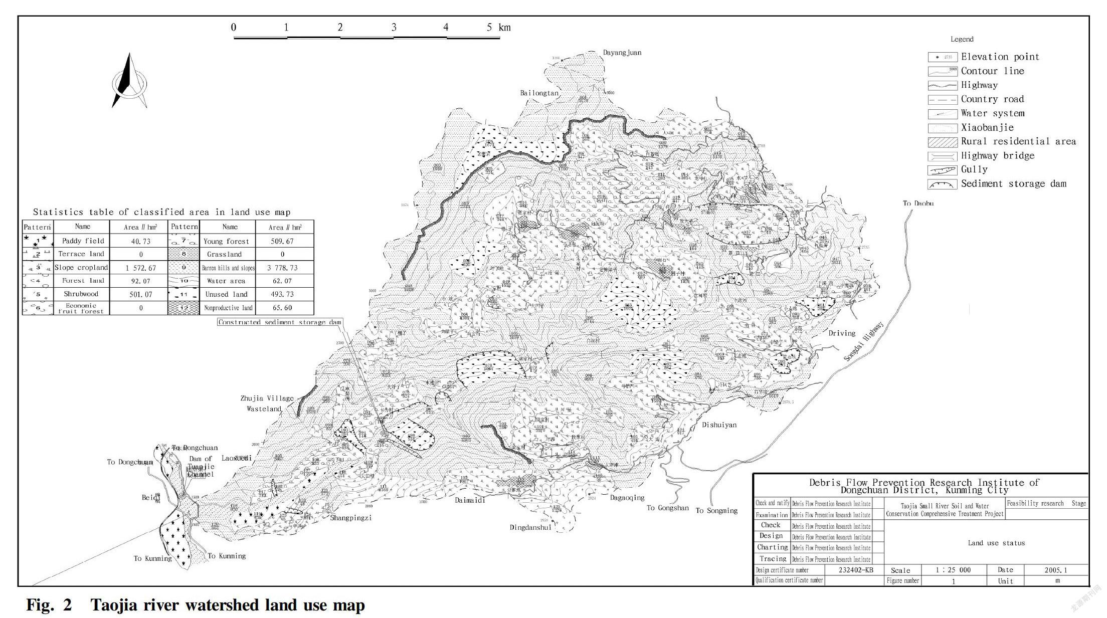
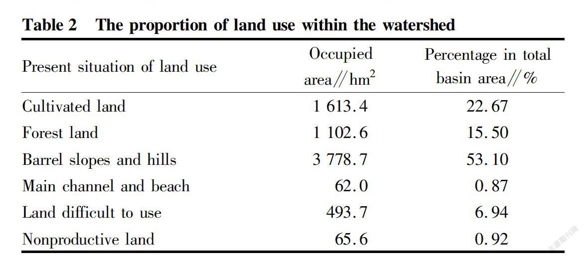
The total area of the Taojia small river basin is about 7 116 hm2, of which the slope cropland and the barren hills have the largest areas of 1 613.4 hm2 and 3 778.7 hm2, respectively. In addition, the forest land has an area of 1 102.6 hm2, of which the open forest land, shrub forest and forested land have areas of 509.7, 501 and 92 hm2, respectively (Fig. 2). The total area of cultivated land in the basin is 1 613.4 hm2, accounting for 22.67% of the total area of the basin (Table 2). The cultivated land per capita is 0.82 hm2, and the reclamation rate is over 95%. In the cultivated land, paddy field is 40.7 hm2, accounting for 2.5% of the total cultivated area; and the slope cropland has an area of 1 572.7 hm2, accounting for 97.5% of the total cultivated area. The paddy fields are all distributed on both banks of the downstream main channel. The per capita paddy field is less than 0.05 hm2, and the slope cropland is less, some of which is the steep slope cropland with a slope over 25°. It is necessary to develop new farmland to solve the problem of insufficient land resources[3]. The middle and upper reaches are all slope cropland, and the cultivated land per capita reaches 1.35 hm2.
According to site investigations, the vegetation coverage rate of the Taojia small river basin is extremely low. Most of the various regions are barren hills and slopes due to serious human disturbance, arid and poor soil and less forested land, and there are only a small number of forested trees around villages. The arbor forest land in the basin is only 92 hm2, and almost all of it is in the upper reaches. The forests are mainly small secondary forests of Pinus yunnanensis, P. armandii and Populus yunnanensis Dode which developed after the 1980s and in which the trees are useful timber. The young forests have an area of 509.6 hm2, which are artificially afforested since 2000. They grow slowly, and most of them are distributed in the gentle hillside area west of the upstream Jiache Township Government. The tree species are mainly P. yunnanensis and P. armandii. There are also a small number of trees distributed on the local slopes on the downstream banks, and the tree species are dominated by Leucaena leucocephala (Table 3)[4]. The shrub forests have an area of 501 hm2, mainly including Rhododendron simsii Planch., Quercus acutissima, Fargesia spathacea Franch, Coriaria nepalensis Wall., Salix myrtillacea, Campylotropis polyantha (Franch.) Schindl., Dodonaea viscosa (L.) Jacq., Solanum deflexicarpum C. Y. Wu et S. C. Huang, etc. They are distributed in small pieces and can only serve as a basic forest for soil and water conservation and provide farmers with fuel. There are no economic fruit forests. Only walnuts, chestnuts, peaches, plums, and flowers are scattered around villages, which have not formed forests.
Haifan WANG et al. The Preliminary Research and Analysis of Ecological Environment Construction in the Small River Basin
Causes and Effects of Destruction of the Ecological Environment
The main causes of destruction of the ecological environment
The forests in the lower reaches of the Taojia small river basin have been continuously destroyed due to the extensive resource development (cropper smelting by charking) in the history of Dongchuan. Before the 1950s, only small amounts of forests in the middle and upper reaches were left. With the expansion of steelmaking and population growth in the Great Leap Forward, the demand for cultivated land and fuel has increased, and poverty has caused local farmers to destroy forests and reclaim land. The current forest coverage rate is 15.5%[5]. Barren hills and slope farmland are most wide in the basin because the forests are cut down to a certain extent, the shrubs and grasses are used as fuel, livestock tramples on the grassland, the topography is steep and the soil is thin, and the secondary forests and artificial forests are developing slowly.
The upper reachesThere are Pinus yunnanensis, P. armandii, Alnus nepalensis, Quercus, and Populus yunnanensis Dode. The shrubs are scattered with Rhododendron simsii Planch., Quercus acutissima, Pyrus calleryana Decne., Vaccinium bracteatum Thunb., Fargesia spathacea Franch, Coriaria nepalensis Wall., et al.
The lower reachesThe trees include Heteropogon contortus, Eupatorium adenophora Spreng., Artemisia carvifolia Buch.Ham. ex Roxb. Hort. Beng., Ficus tikoua Bur., Eucalyptus robusta Smith, Ailanthus altissima, bamboo, Acacia confusa, et al. The shrubs are small amounts of Firmiana platanifolia, Quercus acutissima Carruth., Canarium album (Lour.) Raeusch. and Solanum deflexicarpum C. Y. Wu et S. C. Huang.
Regions with altitudesbelow 2 000 mThe trees are Quercus, willows, E. robusta, A.altissima, etc. The shrubs include Salix myrtillacea, Canarium album (Lour.) Raeusch., P. calleryana, Myrica rubra, Campylotropis polyantha (Franch.) Schindl., Dodonaea viscosa (L.) Jacq. The grasses are mainly E. adenophorum, A. carvifolia, Heteropogon contortus, Imperata cylindrica (L.) Beauv., Arundinella anomala, and Ficus tikoua Bur.
Although 1 572.7 hm2 of slope cropland is widely distributed in the basin and most of it is located in the middle and upper reaches, no slopes have been changed to terraces, and no land has been improved. Moreover, the cultivation methods have also not been improved. Due to factors such as backward productivity, low yield of cultivated land and population growth, poverty has been plaguing local farmers. In addition to working outside the country to earn money, farmers mainly improve their living conditions by increasing the area of cultivated land, resulting in an everexpanding area of slope cropland with a slope over 25°, even reclamation and farming on landslide body[6]. When the steep slope farmland encounters heavy rain, the soil and nutrient loss is very serious, providing a large amount of fine particulate matter for the formation of debris flow[7].
For a basin such as Taojia small river, which relies mainly on agricultural production, the destruction of the ecological environment causes soil erosion and landslide and debris flow disasters destroying farmland, resulting in a rapid reduction of cultivated land in local areas. Farmers lose basic production information and accelerate steep slope cultivation, and postpone the returning of slope cropland on landslide body to forests, leading to a vicious circle of "ecological destruction, soil erosion, reduced farmland, poverty, reclamation of steep slopes, ecological destruction".
Impact of destruction of ecological environment
In the 6 km riverway of the Taojia small river from Goukou to the lower part of Kali Village, before 1990, the nearby farmers had reclaimed about 120 hm2 of paddy field, but with the destruction of ecological environment and the intensification of landslide and debris flow, there is only 40.7 hm2 left[8]. More than 10 hm2 of paddy field had been scattered in Shangchahe Village, and all of it have been buried by mud and rock. The original 50 hm2 of farmland along the Dabai River on the west bank of Goukou has also become wasteland due to sedimentation[9]. About 150 hm2 of slope cropland in areas including Kali Village, Shuicaoqing, Shuijie, Lanjifang, Xintian and other places have been damaged due to landslide and collapse, and 32 hm2 of slope cropland was directly destroyed slope.
Suggestions for Ecological Environment Construction and Restoration
According to the needs of economic, social and ecological construction of the Taojia small river basin, on the basis of the guiding ideology of "prevention first, integrated planning, comprehensive control, adjusting measures to local conditions, giving prominence to the key points and embodying benefits" and "combining water and soil erosion control and ecological resources development and utilization", this paper suggests that the following ecological construction contents should be actively carried out:
Constructing forests for soil and water conservation
In the upstream Shuijie, Xiaomaidi and areas with good water source conditions and thick soil layers, 187.7 hm2 of forest for timber can be constructed. The forest type can be mixed arbor forest. Tree species such as P. armandii and P. yunnanensis can be chosen for the upstream part, and the downstream tree species can be Eucalyptus robusta, bamboo, Leucaena leucocephala (Lam.) de Wit, A. confusa Merr., etc.[10]. The land preparation method is levelterrace site preparation, and the terrace width is 0.7 m; and the afforestation method is planting seedlings with a ground diameter of 0.6 cm at a density of 4 995 plants/hm2. In the vast barren hills in the middle and upper reaches, a firewood forest of 1 374.5 hm2 can be constructed, and the forest type is shrub mixed forest. According to the altitude and soil conditions, the tree species can be selected as follows: R. simsii, Q. acutissima, F. spathacea, C. nepalensis, S. myrtillacea, P. arillata, D. viscosa, S. deflexicarpum, F. platanifolia and C. album. The land preparation method is pitlike site preparation, and the diameter of the digged pond is 0.4 m; and the afforestation method is directseeding afforestation at a density of 6 660 ponds/hm2[11].
Planting fruit trees
In the sections with good water and fertilizer conditions close to villages in the middle and lower reaches, such as Shuijie, 46.8 hm2 of fruit forest can be constructed. Following tree species can be selected: Chinese birthday peach, walnut, Chinese chestnut, etc. The land preparation method is large pond site preparation (diameter×pit depth=0.8×0.8 m), and the afforestation method is planting seedlings with a ground diameter of 1.0 cm at a density of 750 plants/hm2.
Blockading protection
The barren hills and the land difficult to use remaining after afforestation for water and soil conservation and some sparse young forests in the basin can be artificially closed and protected, and the area is 3 418 hm2. Deforestation and grazing should be prevented, to ensure the normal growth of forests and young grasses and the restoration of shrubs and grass vegetations, and reduce the soil erosion of manmade wasteland and land difficult to use[12].
The whole years blockading management and protection can be adopted, and blockading signs can be set up. The blockaded area can be opened orderly in late autumn, allowing the villagers to cut grass and perform prunning on forests under the effective supervision and management of the forest rangers. After three years, according to the vegetation restoration situation, blockading and grazing can be properly rotated.
Implementing soil conservation measures
There is abundant slope cropland in the middle and upper reaches of the basin, which is the main grainproducing base of farmers. The soilconservation cultivation measure can be implemented in 528.8 hm2 of gentleslope arable land, and the measure of planting plants on ridges can be implemented on 51.6 hm2 of steep slope farmland. These measures can achieve water storage, soil conservation and fertilizer conservation, and can also increase the grain yield of slope cropland[13]. The soilconservation tillage measure mainly adopt contour strip cropping, building ridge, intercropping, interplanting and planting methods, and the measure of planting plants on ridges is mainly to plant grasses on ridges to retain soil water.
Planting fastgrowing herbaceous plants on slope cropland in spring and summer not only can green border areas and ridges, but also can retain water and soil, and the plants can be cut to serve as livestock drinks and organic fertilizers, such as Securigera varia (L.) Lassen, Trifolium repens L., Fagopyrum esculentum, green manure, etc. The areas with good water source conditions can also be grown with vegetables, such as beans, soybeans, Amaranthus paniculatus L., etc.; and in local sections with a large slope, we can grown highstem Rudbeckia laciniata L., which not only can serve as a fuel, but also can prevent collapse.
Increasing vegetation coverage and improving greening degree
After implementing water and soil conservation afforestation and blockading protection in the basin, we will strive to increase the forest area by 1 609 hm2 and gradually restore 3 418 hm2 of slopes with sparse shrubs and grasses, so that the total forest area in the basin will reach 2 711.6 hm2. With the increase of forest area and the area of restored slopes with sparse shrubs and grasses after the blockading protection, deforestation should be forbidden, and fires should be prevented. By such, wild animals such as pheasants, hares, squirrels, snakes and birds can get their habitat and breeding environment. The number will increase, and finally, the harmonious biological structure in which animals and plants depend on each other can be constructed.
Enhancing the soil and fertilizer retaining capacities conservation and developing ecological agriculture
Among the farming measures, the soilconservation cultivation will be implemented in the 528.8 hm2 of slope cropland, and the measure of planting plants on ridges will be implemented in the 51.6 hm2 of steep slope cropland, so as to protect the surface soil and organic matter, increase precipitation infiltration, and reduce the erosion of slopes by heavy rain. Meanwhile, the grasses planted on ridges and the blockading protection can provide forage, feed and green manure, grazing can be changed to rearing in pens and developing biogas fuel, and the amount of organic fertilizer applied by farmers on slope cropland can be increased, so as to increase grain yield and raised livestock. Extensive and predatory farming methods and backward energyadoption methods in the past will be changed, and scientific and sustainable ecological agriculture economy will thus be realized.
Conclusions
Due to serious disasters, the primary goal of the ecological environment construction in the Taojia small river basin is to control the extreme disasters of soil erosiondebris flow and landslide, to significantly reduce soil erosion and effectively protect the safety of villages, water conservancy, transportation and farmland. On the basis of the cultivation conditions of slope farmland and the water conservancy facilities of farmland, it is necessary to develop and utilize ecological resources and develop the economy to improve the living standards of the local people.
References
[1] ZHANG WY. Exacerbated by human activities cause soil erosion and its manifestations[J]. Soil and Water Conservation Science and Technology In Shanxi, 1999(1): 26-27. (in Chinese)
[2] GU JZ. Dongchuan old landslide gangou comprehensive treatment[J].Subtropical Soll and Water Conservation, 2006, 18(2): 55-57. (in Chinese)
[3] ZHOU QK, XU LL, WEI ZY, et al. Zhijin County analysis of soil erosion in sloping land [J]. Modern Agricultural Science and Technology, 2010(17): 315-316. (in Chinese)
[4] SHENG WT. Chinese fir plantation soil erosion and nutrient loss study[J]. Forest Research, 2000, 13(6): 589-597. (in Chinese)
[5] XIAO N. History of the region cutting pay Dongchuan copper charcoal consumption of forest resources[J]. Forest Inventory and Planning, 1988(3). (in Chinese)
[6] JIA SW, WEI FQ, CUI P. Analysis of land use change and its changing trend in Xiaojiang Basin[J]. Journal of Soil and Water Conservation, 2006, 20(5): 154-157. (in Chinese)
[7] CHEN SB, HUA L. Effect of soil erosion on soil properties in deep cultivated hill slope in Loess Plateau[J]. AgroEnvironmental Protection, 2002, 21(4): 289-292. (in Chinese).
[8] ZHANG GX, WANG SG. Probe into ecological environment and measures for protection of Xiaojiang River[J]. Research of Soil and Water Conservation, 2006, 13(5): 50-52. (in Chinese).
[9] KUANG WJ, MENG TY, YANG XC. Functions of silt arresters and check dams in soil and water conservation protection system of Hezhang County[J].Soil and Water Conservation In China, 2007(8): 44-45. (in Chinese)
[10] SHENG YX, LIU WY, ZHANG YD. The effect of rehabilitation on vegetation species composition and soil seed bank at a degraded dry valley in Dongchuan,Yunnan Province[J]. Acta Ecologica Sinica, 2003, 23(7): 1454-1460. (in Chinese)
[11] ZHAO Y, LI SR, WANG N, et al. Japanese larch different land preparation methods of soil hydrological effects[J]. Journal of Henan Forestry Science and Technology, 1995(3). (in Chinese)
[12] TAO Y, JIANG Y, GU W, et al. Competition between growth of herb and shrub in slope protection with plant community[J]. Journal of Northeast Normal University (Natural Science Edition), 2011, 43(2): 140-144. (in Chinese)
[13] HE L, DUAN YT, SHA YC, et al. Study on ecology and economy benefit of ecoeconomic forestry composite planting mode in Jinsha river hot and dry valley[J]. Journal of Soil and Water Conservation, 2006, 20(5): 16-19. (in Chinese)

- 农业生物技术(英文版)的其它文章
- Observation on Cardiac Opening of the Inferior Vena Cava in Goat Fetuses
- Evaluation on Application and Spraying Effect of AirAssisted Sprayer in Apple Orchard with Dwarfing Rootstocks
- Problems in the Development of Traditional Chinese Medicinal Materials Planting Industry in Shiyan City and Countermeasures
- Study on Practical Mature Age of Individual Pinus thunbergii×P. densiflora
- Effects of Different Densityreducing Methods on Canopy Microenvironment, Tree Growth and Fruit Quality in Closed Apple Orchard
- Development of Whole Potato Flour Fish Noodles