
Impact of and adaptation strategiesfor sea-level rise on Yangtze River Delta
2018-07-26 09:47:16WANGQiuShunPANCunHongZHANGGuangZhi
WANG Qiu-Shun,PAN Cun-Hong,*,ZHANG Guang-Zhi
a Zhejiang Institute of Hydraulics and Estuary,Hangzhou 310020,China
b Zhejiang Institute of Marine Planning and Design,Hangzhou 310020,China
Abstract The Yangtze River Delta characterized by a dense population and a rapidly developing economy is highly vulnerable to sea-level rise.The data from the China Oceanic Information Network and the Zhejiang Provincial Hydrology Bureau are used to analyze sea-level rise.The rate of sea-level rise in the delta was 2.4 mm per year in 1981-2015.The annual sea-level at Daishan,Dinghai,and Dongtou stations in the south wing of the delta were 4.3,3.1,and 5 mm per year respectively over the same period.The 10-year averaged results at each station also indicate a perceptible trend of sea-level rise.Sea-level rise is contributed to a larger proportion of intensified erosion,ranging from 3%to 14%in the delta.Meanwhile,the 100-year return period of tidal level has decreased to the 50-year rank at Dongtou and Dinghai stations.Moreover,the arrival time of tidal boresat Yanguan is4 min earlier under sea-level rise of 0.145 m than that of 0 m.The height of tidal boresand thevelocitiesat the surface and bottom layers have an increase under sea-level rise.The maximum increases of high and low tide levels are 0.122 m and 0.016 m while the maximum increases of the velocities at the surface and bottom layers are 0.07 m s-1 and 0.05 m s-1,respectively.Sea-level rise will bring about the damageof seawall,thusthe design standard of constructing seawallsshould adopt ahigher level to minimizetheassociated risks in the Yangtze River Delta and its south wing.
Keywords:Coastal erosion;Sea-level rise;Saltwater intrusion;Tidal bore;Yangtze River Delta;Zhejiang province
1.Introduction
Sea levels remained nearly stable or about 3000 years,but havebeen rising throughout the 20th century,which isa direct outcome of global climate change.The IPCC(2013)reported that the global mean sea-level would continue to rise during the 21st century,and the rate of this rise would likely exceed that observed during 1971-2010.A relatively higher sea-level rise in the range of 28-98 cm is predicted for the year 2100(IPCC,2013).Historical tide records show that the sea-level around China has increased 90 mm over the past 30 years(www.coi.gov.cn).Continued sea-level rises will threaten people in low-lying zones and will increase damage risks,particularly in densely populated deltas.
The Yangtze River Deltaisvulnerableto sea-level riseasa low-lying coastal plain.Population in the delta increased by 58%from 1996 to 2013(Cheng and Chen,2016).The threats associated with sea-level rise were involved to estuarine ecosystem and city safety in the delta(Cheng and Chen,2016).Zhou et al.(2013)indicated that sea level rise induced severe beach erosion along the northern coastsof the Yangtze River Estuary.Researchers revealed that sea-level rise intensifi es saltwater intrusion in the delta(Yang and Zhu,1993;Chen et al.,2016;Qiu and Zhu,2015).Consequently,the combined effects of sea-level rise and fl ood have increased the risk levels in the delta.Kuang et al.(2017)indicated that the increase in sea-level caused by river dischargewas6.8%-8.9%of thetotal rise.Sea-level risewas predicted to result in a relatively larger terrestrial area becoming inundated at Chongming Island(Tian et al.,2010).Cui et al.(2015)indicated that sea-level rise caused losses of coastal wetlands in the Yangtze River Estuary.Additionally,sea-level rise has an effect on tides.Kuang et al.(2014)indicated that sea-level rise had the potential to advance the tidal limit and the tidal current limit in the Yangtze River Estuary.Gong et al.(2012)found that the tidal range and the duration of fl ood and ebb tides would change in response to sea-level rise.Meanwhile,Shi et al.(2000)studied the effect of sea-level rise on Yangtze River Delta and adjacent areas,and indicated that the most seriously affected area was Shanghaiand then wasthenorth of Hangzhou Bay.Theeffect of sea-level rise on Shanghai(Deng and Fan,2002;Cheng et al.,2015)indicated that the safety of Shanghai would be threatened by sea-level rise.Sea-level rise is affecting levee breaches and overtopping along the Shanghai coast,and possible storm surge fl ooding at the maximum tide level could cause nearly total inundation of the landscape(Yin et al.,2011).In recent years,the Yangtze River Delta has suffered more frequent disturbances associated with sea-level rise.However,minimum research involves the impacts on the south wing of thedelta.Theoverall infl uence of sea-level rise may be greatly underestimated in the region.
Currently,the infl uences have been intensifi ed in the delta,which will signifi cantly affect human activities.At the south wing of the delta,fl ood disasters occur frequently and show greater destructive power in Zhejiang province.In addition,tidal bores are popular scenic spots here as well as worldwide.With sea-level rising,the estuarine resources will be affected.Although some response strategies were proposed to accommodate sea-level rise in Yangtze River Delta(Shi et al.,2000;Yang et al.,2003),it is necessary to employ strategies for dealing with the current situation.Therefore,official databases for sea-level rise are being analyzed to determine the current sea-level changes in the region and to consider the likely impacts from sea-level rises.Additionally,adaptation strategies have also been proposed for managing the potential impacts on the Yangtze River Delta.
2.Materials and methods
The offi cial database for sea-level rise released by China's State Oceanic Administration(www.coi.gov.cn)was employed.Here we use annual sea-level data in 1981-2015 from the China Oceanic Information Network.On the basis of annual sea-level data,the 10-year averages were to illustrate the trend of sea-level rise over the long-term.Three representative stations (Daishan, Dinghai, and Dongtou)in Zhejiang province were chosen to demonstrate the sea-level rise trends in the south wing of the delta(Fig.1).Since these stations are located on islands,their long-term data are more precise and less affected by anthropogenic factors.Additionally,the stations are more sensitive to sea-level change due to low tidal levels.Therefore,we use the tidal level data of the Zhejiang Provincial Hydrology Bureau from 1981 to 2015 for these three stations.With respect to saltwater intrusion,we use data from the China's Marine Disaster Bulletin.To determine the sea-level change in the delta,a multi-sites average from nearby stations from the Yangtze River Estuary to the Taiwan Strait was employed,which was reconstructed from data of the Chinese Sea-Level Bulletin.1http://www.coi.gov.cn/gongbao/nrhaipingmian/nr2015/201603/t20160328_33810.html.
We statistically analyzed these data using SPSS(Statistics Package for Social Sciences)software and used a pairedsamples t-test to determine the reliability of these trends.To demonstrate the effect of sea-level rise on tidal bores,a threedimensional model based on FVCOM(Finite Volume Coastal and Ocean Model)was employed to simulate the evolution of tidal bores.It was validated in the literature of Wang and Pan(2017).The tidal level at open boundary was elevated by sea-level rise on the basis of the measured data and then was exerted to demonstrate the variation of tidal level at Yanguan.
3.Sea-level changes
Fig.2 shows the annual variation of sea-level change and the 10-year averaged change.The base level is the average of 1975-1993,as determined by the global sea-level monitoring system.From Fig.2,we can see the sea-level in the delta gradually increased to a relatively higher level despite fl uctuations.The average rate of sea-level rise in 1981-2015 was 2.4 mm per year,which exceeds the global mean rise rate(Church and White,2006).Moreover,sea-level appears to be higher in 2000-2015.High sea levels occurred in 2002 and 2015,whereas there were relatively lower sea levels in 2001,2005,and 2013.The result of the paired-samples t-test indicated that there was no significant difference between the 10-year averaged change and the annual variation.It reveals the reliability of the trend between the 10-year average change and the annual variation.
Since sea-level rise are non-uniform around the delta,we used data from three local stations in Zhejiang province,i.e.,Daishan,Dinghai,and Dongtou to determine the change in the south wing of the delta.
Fig.3 shows the sea-level change of the three stations in Zhejiang province for 1985-2012.The base level is the average of 1952-1979,as determined by National Vertical Datum 1985.From Fig.3c,we can see that sea-level gradually increased with some fl uctuations,and the sudden decrease in 1999 was probably associated with the year of El Ni~no.In recent years,high sea levels have occurred frequently and indicate a relatively higher rise.Moreover,the annual rise rates at Daishan,Dinghai and Dongtou were 4.3,3.1,and 5.0 mm per year,which are greater than the global mean level(Church and White,2006;Hay et al.,2015).The resultsof the paired-samples t-test were no signifi cant differences at the three stations.From these results,we can deduce that the local variations of sea-level rise in Zhejiang province were greater than the overall results in the delta.Fig.4 shows the 10-year mean sea-level changes at the three stations,which indicates that the sea-level at Dongtou has increased more than that of the other two stations since 2000.In recent years,the trend of sea-level rise has been perceptible at each station.Sea-level rise is expected to range from 70 to 145 mm over the next 30 years(www.coi.gov.cn).
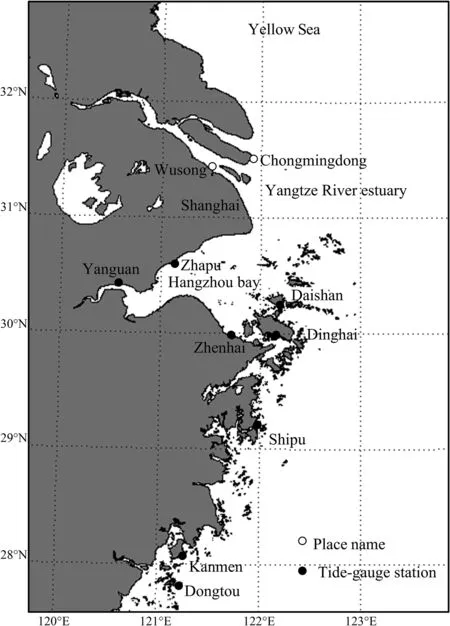
Fig.1.Locations of stations of the Yangtze River Delta.
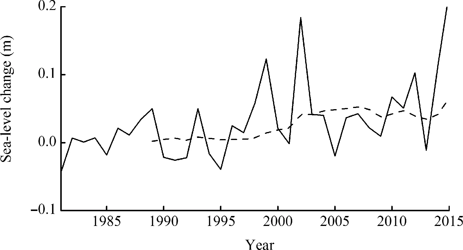
Fig.2.Sea-level change(relative to 1975-1993)on the north coast from the Yangtze River estuary to the Taiwan Strait from 1981 to 2015(dashed line illustrates the 10-year average).
4.Impacts of sea-level rise
4.1.Intensified erosion
The direct impact from sea-level rise includes accelerated erosion in the Yangtze River Delta.Based on the Bruun Rule,Shiet al.(2000)show thecoast would recede2.8 m with asealevel riseof 1 cm.Asaconsequence,for arateof sea-level rise of 1.5 mm per year,the average coastal recession would be 0.4 m per year.Compared with the measured result,the contribution of sea-level rise to coastal erosion was only 1%.If sea levels rise 30 cm by 2050,that contribution would increase to 8.6%(Shi et al.,2000).Since the potential sea-level rise is great in the delta,its contribution to erosion will increase correspondingly.If we take the Chongmingdong beach as an example,which is located at the front of the Yangtze River Delta,data records for a distance of 48 km show that extensive erosion has occurred during 2012-2015.The minimum length of coastal erosion observed was 2.5 km at the beach,and severe erosion occurred in 2012 over a distance of 3.2 km.During 2012-2015,the annual erosion rate has been greater than 5 m per year,and the maximum increase relative to 2011 was22.4 m in 2012.Since theerosion rate is0.7 m per year for a sea-level rise of 2.4 mm per year in the delta,the proportion it contributes to annual erosion will correspondingly increase to 3%-14%compared with the result of the Bruun Rule and monitoring erosion.Additionally,the Three Gorges Dam has impact on the river hydrology and sedimentology in the deltaic regions(Dai and Liu,2013).The sharp reduction of sediment supply due to the Three Gorges Dam is a major factor contributing to the erosion.
In the estuary,sea-level rise slowed sedimentary accretion and caused erosion along the south coast(Chen and Zong,1999).In the south of the delta,the area north of Hangzhou Bay has experienced signifi cant erosion(Cao et al.,2009;Shi et al.,2011),and the beach suffered a larger magnitude scour from 1998 to 2008 in this region.The 0-m depth contour retreated 5.7 m per year during 1998-2008(Shi et al.,2011).Theunderwater sloperetreated landwardsdueto theerosion in the north of the bay.Based on sea-level rises at Daishan and Dinghaiof 4.3 and 3.1 mm per year,thecorresponding erosion would be 1.2 and 0.9 m per year according to the Bruun Rule.Thus,sea-level rise will contribute 15%-21%to the total erosion,which is a noticeable increase compared to the previous result in Hangzhou Bay(Shi et al.,2011).The enhanced erosion rate in the delta is closely associated with the effect of sea-level rise,and larger rise will contribute to the greater proportion of coastal erosion.
4.2.Aggravation of saltwater intrusion
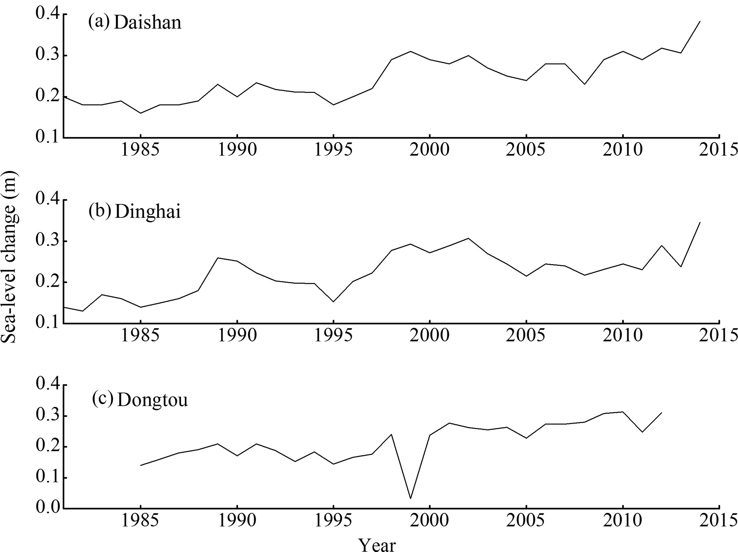
Fig.3.Sea-level anomaly during 1981-2015 at(a)Daishan,(b)Dinghai,and(c)Dongtou(relative to 1952-1979).
The aggravation of saltwater intrusion isalso an outcomeof sea-level rise,as rising sea levels increase the strength of the longitudinal salinity.Table 1 shows statistics for saltwater intrusion in the Yangtze River Estuary.It isseen that saltwater intrusion processes were recorded on three occasions during 2012.Two of thesewere recorded by the Yangtze Hydropower Station.A long-lasting intrusion occurred on 7 January,2012 and was the severest,with a duration of 7 d and a maximum salinity of 9.06 psu.Saltwater intrusion intensities and stratifi cations both increased with sea-level rise,and their increments were quite distinct in the delta(Qiu and Zhu,2015).The 1,2,and 5 psu isohalines near the north bank of the estuary intruded farther upstream than thosenear thesouth bank,and the upstream advancement distance of the 0.45 psu isohaline was much greater than those of the 1,2,and 5 psu isohalinesunder sea-level rise(Chen et al.,2016).In 2013,the frequency of saltwater intrusion increased to nine times.A saltwater intrusion of long duration occurred in the early winter months of November and December.The number of saltwater intrusions increased to six on 20 November,compared with the corresponding period in 2012.For saltwater intrusions in 2013,seven were recorded at the Baogang Reservoir.The most serious and longest duration intrusion started on 6 December and lasted for ten days.The highest salinity of 1.59 psu was recorded on 10 December.The intrusion distance of the 1.5 psu isohaline under sea-level rise increased to the upstream of the estuary(Luo et al.,2011).During 2015,saltwater intrusions were recorded on three occasions in January and February.The one with the longest duration began on 23 February and lasted seven days.The highest salinity of 1.29 psu was recorded at the Baogang Reservoir on 25 February.High salinity levels from the saltwater intrusion started on 31 January and lasted for fi ve days.At the Qingcaosha Reservoir,the highest salinity of 2.18 psu was recorded on 2 February.As the sea-level has increased,high salinity levels have extended into a larger zone.At Wusong station,chlorinity signifi cantly increased under a relatively higher sea-level,and the increase in the spring tide wasreported to be significantly higher than that in the low tide(Yang and Zhu,1993).
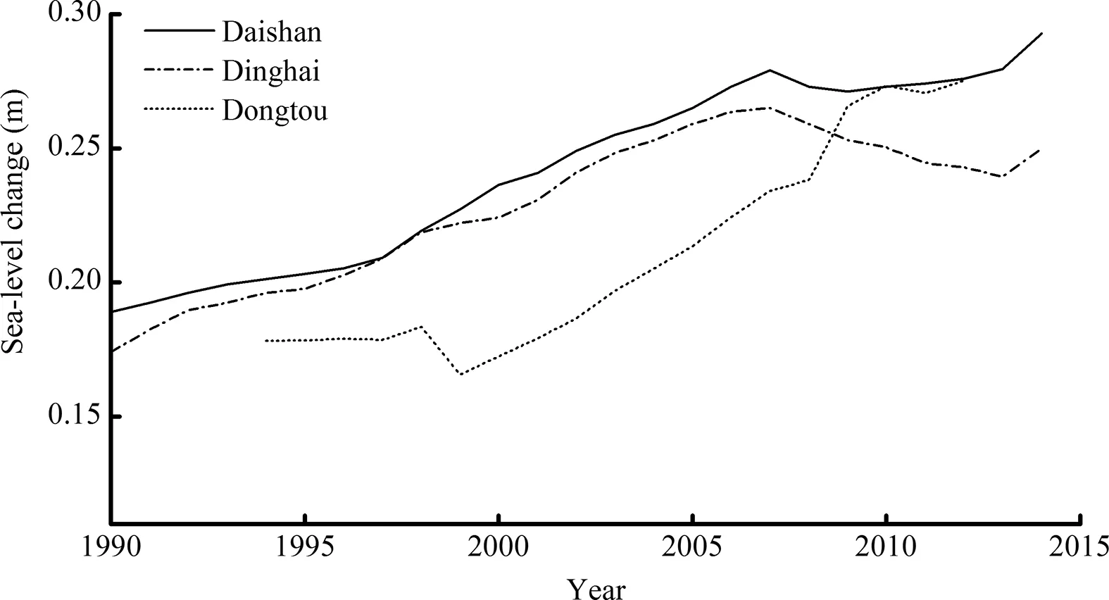
Fig.4.Ten-year averaged sea-level at Daishan,Dinghai,and Dongtou stations during 1990-2015(relative to 1952-1979).
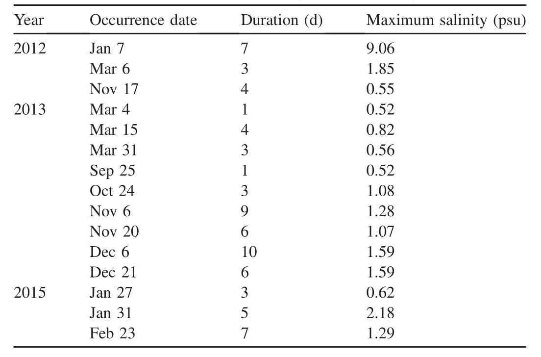
Table 1 Statistics on saltwater intrusion in the Yangtze River Estuary.
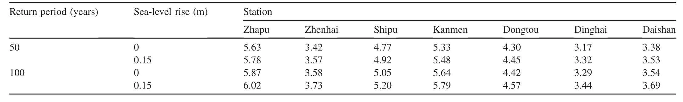
Table 2 Highest tidal level with different return periods under sea-level rise.
Additionally,many occurrences of saltwater intrusion were recorded at theupstream of Hangzhou Bay.Saltwater intrusion in Hangzhou Bay was aggravated by sea-level rise in September 2010,and the saltwater intrusion distances increased to 19 km and 19.5 km by sea-level risesof 0.5 m and 1.0 m,respectively(Lu et al.,2013).During dry seasons,saline water had dominated the deltaic area for much longer periodsand threatened suppliesof freshwater(Chen and Zong,1999).Meanwhile,the quantity of freshwater will decrease and the unfavorable intake time will increase with sea-level rise.Consequently,it is urgent to take action to deal with the intensified saltwater intrusion.
4.3.Exacerbation of storm surge
Thecombination of sea-level riseand storm surgeincreases thevulnerability to fl ooding.Millions of people in many areas of Zhejiang suffer storm surges.In 2014,coastal engineering works were destroyed in the storm surge over a distance of 6.74 km.Meanwhile,the maximum storm surge level at the Ganpu station was 312 cm during Typhoon Chan-hom in July 2015.The tidal level exceeded the warning threshold in the coastal zone.The strong Typhoon Fitow caused economic losses of about CN¥44.9 billion in October 2013,and affected nearly 6.66 million people in coastal cities.Sea-level rise increased the frequency of storm surges and enhanced their destructive forces(Sun et al.,1997).Additionally,the strength of storm surgeisaffected by sea-level rise.Asthewater depth increases,the celerity and height of breaking waves are enhanced.With higher sea levels,storm surges will significantly impact seawall in the delta,and the area north of Hangzhou Bay may be less able to adapt to a higher sea-level.Under sea-level rise,the return period of the highest tidal level will decrease.In Table 2,it is seen that the 100-year return period of the highest tidal level decreases at every station with a sea-level rise of 0.15 m,and especially at Dongtou and Dinghai stations.The exacerbation of storm surge led to the delta suffering more disasters(Wang et al.,1995).Taking the seawall in the Yangtze River Estuary as an example,strengthening the seawall required an investment of about CN¥100 million(Yang and Wang,1998).It is known that making seawall enhancements to diminish the effects of sealevel rise will mean high costs.Therefore,rising sea levels make seawall suffering from greater destructive forces under the exacerbation of storm surges.
4.4.Effects on tidal bores
To illustrate the effect of sea-level rise on tidal bores,numerical model was used to reveal the difference at Yanguan.Since the maximum rise in sea-level is expected to be 145 mm in the next 30 years(www.coi.gov.cn),Fig.5 gives the comparison of surface elevations at the arrival of tidal bores.It is seen that high tidelevelsaresignifi cantly elevated by sea-level rise of 0.145 m.The maximum increase of high tide level is 0.122 m whiletheriseof low tidelevel is0.016 m.Thepattern of tidal bores has no remarkable deformation,but indicates a larger height of tidal bores in response to sea-level rise.Moreover,the arrival time of tidal bores is 4 min earlier under sea-level rise of 0.145 m than that of 0 m.As a consequence,the occurrence of tidal bores will be in advance.
Fig.6 presents the corresponding comparisons of velocities at the surface and bottom layers.It is noted that the velocities show an increase by sea-level rise of 0.145 m during the passage of tidal bores.The maximum increases of the velocities at the surface and bottom layers are 0.07 m s-1and 0.05 m s-1,respectively.It is known that the propagation speed of tidal bores is enhanced with greater water depths,thus signifi cantly strengthening the tidal bores under sea-level rise.The large rise in sea-level will notably affect the evolution of tidal bores.Consequently,it will cause greater destructive forces due to the enhanced tidal bores.
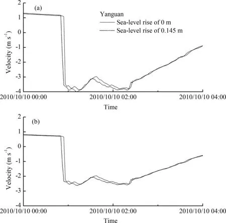
Fig.6.Comparisons of velocities at the arrival of tidal bores at(a)the surface layer,and(b)the bottom layer.
5.Adaptation strategies
Sincetherearedensepopulationand developed economy in the delta,embankments should be built to protect these resources.Seawall isaneffectivetool for eliminatingtheimpacts of sea-level rise on the delta.The length and height of the current seawall are far from enough in dealing with the disasters due to sea-level rise.As sea-level rises,the original safety standard of seawall will be less adequate.To maintain the original safety level,seawall must be widened and heightened.The design criteria for seawall should also be strengthened and a higher protection standard will be necessary in light of the trends of sea-level rise in the delta.The designstandard of constructingseawallsshould adopt ahigher level at Dongtou and Dinghai.Theconstruction of seawall not only prevents coastline recession,but also reduces the effects of storm surge and tidal bores.It isimportant to maintain both the safety of the delta and the integrity of the landscape.
Recently,many coastal useprojectshavebeenimplemented in thedelta,whichhaveserved toacceleratesea-levelriseinthelocal region.Therefore,coastal use should be controlled to decrease intensified erosion.Asthereduction of sediment suppliescauses the erosion in the delta,the exploitation of sediment in the nearshore should be forbidden.Additionally,beach supplementation should beestablished to deal with intensified erosion.
In view of the aggravation of saltwater intrusion,it is necessary to schedule water resource at the upstream of the delta.Additionally,a comprehensive understanding of the situation will help planners to make rational decisions for managing the delta's natural resources.As yet,decisionmakers have little knowledge about sea-level rise since this issue has not been given high priority(Jin and Francisco,2013).Water resources managers should take action to reduce the effects of saltwater intrusion,and relevant information should be readily provided to increase public awareness of the need for water resources management.
6.Conclusions
Therearesignificantvariationsinsea-levelriseinthe Yangtze River Deltaand theaveragevalueishigher inrecentyearsthanin precedingtimes.Therateof sea-levelrisewas2.4mmperyear in 1981-2015 in the delta,while the annual sea-level rise at Daishan,Dinghai and Dongtou were 4.3,3.1,and 5.0 mm per year.Therateof sea-level risein thesurrounding region appears to be higher and exceedsthat in the delta.
Coastal erosion,saltwater intrusion,and storm surge intensity in the delta are all aggravated by sea-level rise.The contribution of sea-level rise to coastal erosion is 3%-14%in the delta,which has gradually increased under sea-level rise.Additionally,the 100-year return period of tidal level would decrease to a low rank under sea-level rise at Dongtou and Dinghai stations.Moreover,the arrival time of tidal bores at Yanguan becomes earlier under sea-level rise.The height of tidal bores and the velocities at the surface and bottom layers have an increase under sea-level rise.The maximum increase is 0.122 m in tide levels and 0.07 m s-1in the velocities.
A diversity of possible adaptation strategies can be adopted in response to sea-level rise.Seawall design criteria should be developed and a higher protection standard will be necessary in light of the trend of sea-level rise.Additionally,beach supplementation should be established and coastal use should be controlled to avoid potential risk induced by sea-level rise.Meanwhile,the issue of sea-level rise must be given high priority in public policy,and relevant information should be promptly provided to facilitate water resources management.The current study is based on the analysis of the dataset in 1981-2015,which might not becompletely accurate to reveal the long-term sea-level change.Since the delta is selfadjusting in the long-term evolution,the impacts of sea-level rise might be overestimated.However,it is alert to prepare for the very real threats to the delta.
Acknowledgements
This work wassupported by theprojects of National Science Foundation of China (41706099,51779228,51379190,41676085),and the Science and Technology Plans of Zhejiang province(2015F50011,2016F50017).The authors acknowledgedtheanonymousreviewers'commentstoimprovethispaper.
 Advances in Climate Change Research2018年2期
- Advances in Climate Change Research的其它文章
- 1.5°C target:Not a hopeless imagination
- Development path of Chinese low-carbon cities based on index evaluation
- China's nuclear power under the global 1.5°Ctarget:Preliminary feasibility study and prospects
- Analysis on the synergistic effect of sustainable development of coal industry under 1.5°C scenario
- Changes in temperature extremes over China under 1.5 °C and 2 °C global warming targets
- Changes in surface air temperature over China under the 1.5 and 2.0°C global warming targets