Comprehensive quality evaluation on arable land allocated for basic vegetable production in metropolitan suburb
Liu Yu, Pan Yuchun, Ren Yanmin, Hu Yueming
Comprehensive quality evaluation on arable land allocated for basic vegetable production in metropolitan suburb
Liu Yu1,2, Pan Yuchun1,2※, Ren Yanmin1,2, Hu Yueming3
(1.100097,; 2.100097,;3.,,510642,)
Designation of basic vegetable land aims to improve production capacity and ensure a balanced supply of vegetables in urban areas. This research built a comprehensive evaluation model of arable land selected for basic vegetable production in the Pinggu District of Beijing in order to provide a scientific basis for allocating basic vegetable land in metropolitan suburb. The results showed that: 1) the primary needs of arable land quality for vegetable production and the policy requirement of the state and the Ministry of Agriculture for basic vegetable production were the fully considered in the comprehensive quality evaluation of arable land allocated. This focused on four aspects: land quality, ecological adaptability, space stability, road accessibility and planting habit, including the supply and need of water resource, main water source protection zone and other indexes; 2) based on the results of the above evaluation, the possible areas of arable land in Pinggu District were divided into the most suitable areas (>82), suitable areas (>75-82), sub-suitable areas (>67-75) and unsuitable areas (≤67). Among which the most suitable area was the initial choice for basic vegetable production, an area of 3 472.33 hm2, which was mainly located in Donggaocun Town, Xiagezhuang Town, Shandongzhuang Town and Daxingzhuang Town around the Pinggu new town. Suitable area and sub-suitable areas were potential reserve areas for basic vegetable production. 3) It is suggested that by focusing on the construction of a “Non-Staple Food Project” in Beijing, the hierarchical construction and protection of basic vegetable land should be enhanced to form a vegetable production pattern with outdoor vegetable, facility vegetable and vegetable park mutually complementing with each other.
land use;evaluation; models; basic vegetable land; spatial pattern; Pinggu District
0 Introduction
Vegetable is one of the most important basic foods for people’s nutrition balance and daily diet[1]. With the growth of population in metropolitan areas and the upgrade of consumption structure, the demand for vegetable will continue to increase[2]. In recent years, low self-sufficiency for vegetables in large and medium-sized cities, among a series of other problems existing in the production, circulation and sale[3-4], has aroused extensive attention in the government and educational circles[5-7]. Especially in suburb of metropolis with a strained man-land relationship as well as rapid decrease of arable land, the extension of urban center to suburb results in a constant reduction and transfer of vegetable field in suburb, which not only influences urban vegetable supply, but also causes the loss of agricultural infrastructure investment. The “National Vegetable Industry Development Plan (2011-2020)” clarifies that vegetable production bases in metropolitan cities shall be rationally laid out to improve self-sufficiency and emergency supply capacity. It states that a multi-level layout for commercial vegetable production at short, intermediate and long distance areas for large, medium and small sized cities, and a complete systematic network for multi-direction flow for vegetable delivery and distribution are an effective approach to ensure balanced vegetable supply around the year[8]. Therefore, it is necessary to determine the minimum required conservation of perennial vegetable land and designate it to ensure the stable and balanced supply of vegetables in metropolitan cities by improving vegetable production capacity.
The rational arrangement of basic vegetable land involves the local natural resources, society, economy, technology and so on. It can lead to area reconstruction and is also a process of industrial optimization[9]. In recent years, domestic research on vegetable production focused on the spatial distribution, evolution characteristics, formation mechanism and policy response at macro level. The organization of vegetable production base at micro level is obviously insufficient[2,9-11]. Tianjin, Hohhot, Baotou and other cities have successively issued and implemented “Regulations on Protection and Management of Basic vegetable land” to further regulate their management and protection, but there is insufficient quantitative research on their designation. However, much research has been carried out in China centering on the standard, designation, construction, management and protection of basic farmland[12-14], and the technical methodology of designation is relatively mature. Considering that the requirements of vegetable production for land resource, water resource, labor skill, road access and ecological environment are apparently higher than for the production of general agricultural products[15-19], which means that vegetable planting faces greater restriction[20], there are some differences in the evaluation criteria of basic vegetable land. Moreover, some scholars study the designation of basic vegetable production from the aspects of resources and farmers' decision-making behavior[15,21]. Hence, establishing systematic designation method referring to relevant assessment is an important task to be urgently studied.
In accordance with the “Comments on Integrating Development of‘Non-Staple Food Project’ Construction in Beijing to Ensure Market Supply and Basically Stable Price” and the “Comments on Structure Adjustment and Mode Transformation to Develop Efficient and Water-saving Agriculture (J.F. No. [2014]16)”, the minimum conservation of basic vegetable land in Beijing is 46 667 hm2,giving an average annual self-sufficiency ratio of vegetable production at around 35%. Centering on this objective, Beijing is aiming to create a main vegetable producing region, focusing on the “Wanmu Town, Qianmu Village and Baimu Park” regional integration and promotion project for vegetable industry, directing vegetable planting to suitable producing areas. Considering this, and combined with the requirements of current relevant policies, a systematic comprehensive quality evaluation method of basic vegetable land in suburbs of metropolitan areas is designed on the basis of defining the characteristics of basic vegetable land, in the hope of providing a scientific basis for the designation of basic vegetable land and enriching the quality evaluation research of arable land.
1 Data sources and research methods
1.1 General conditions of the study area and data resources
Pinggu District is located at the intersection of the south foot of Yanshan mountain and the north of the Huang-Huai-Hai Plain. It is surrounded by mountain in the north, east and south, and embraces a plain valley in the middle, covering an area of 948.35 km2. Pinggu District is an ecological conservation area, with 62.7% forest coverage in 2012, and 68.1% woody plant cover. The area of arable land is 12 293 hm2, mainly distributed in Donggaocun Town, Mafang Town, Yukou Town, Xiagezhuang Town and Machangying Town. It belongs to a warm temperate continental monsoon climate, having abundant sunshine, clear seasons and suitable climate condition to plant various vegetable. The district has a long history of vegetable planting, and the planting area and gross output have been remarkably increased in recent years (Fig.1). Vegetable production gradually transfers from the past “family garden” to urban agriculture business and it has become a significant cause of farmers’ income growth.
Main data resources: arable land data from “Land Use Status Database of Pinggu District in 2012”; regulation zone and basic geographic information from database of(2006-2020); topsoil surface, soil organic matter, drainage condition, irrigation condition, profile pattern and arable land quality indicators data from “Achievement of Agricultural Land Appraisal in Pinggu District”; water resource situation in Pinggu District from distribution diagram of groundwater overdraft areas and emergency water source distribution diagram in Pinggu District; extract gradient information from the DEM data; vegetable planting area and other social economic data from “Statistic Yearbook of Pinggu District in 2013” and “Beijing Regional Statistical Yearbook 2013”
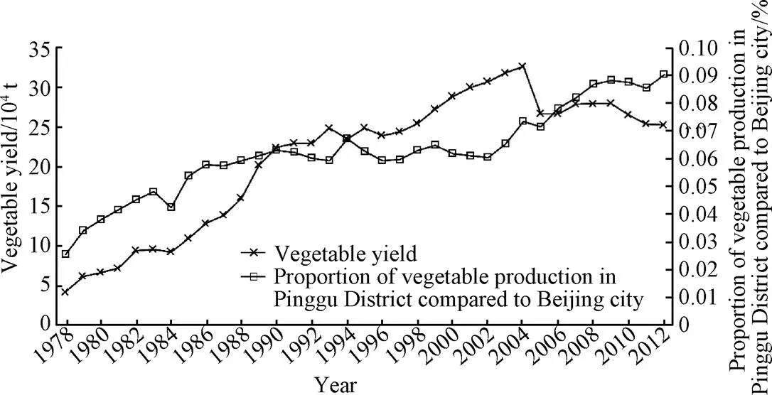
Fig.1 Vegetable yield and its proportion in Pinggu District compared to Beijing City
1.2 Comprehensive quality evaluation indexes of basic vegetable land
Referring to the “Regulations of Tianjin Municipality on Protection and Management of Basic vegetable land”, “Regulations of Hohhot City on Protection and Management of Basic vegetable land”, “Regulations of Baotou City on Protection and Management of Basic vegetable land”, and combined the definition of basic farmland, basic vegetable land is defined as: existing vegetable field engaged in vegetable production in the long term and reserve vegetable land planned for development approved and determined by people’s government based on urban and rural people’s demand for vegetable and prediction of the development tendency of construction land. Protected area of basic vegetable land includes the commercial vegetable land already cultivated, newly-cultivated perennial vegetable- specific land and land for vegetable scientific research, teaching, demonstration and selective breeding. Generally, basic vegetable land shall meet the following conditions: high soil quality and ideal farmland infrastructure; near to the vegetable consumer market and with convenient transportation; favorable ecological environment, fewer natural hazards and without pollution sources that may influence vegetable quality. Basic vegetable land in metropolitan suburbs is a special type of arable land, so it must pay more attention to the inheritance and difference in the construction of index system. On the one hand, the index system must absorb and draw lessons from the existing research on delineation of permanent basic farmland; on the other hand, it also reflects the differentiation requirements of basic vegetable land location. Abiding by the criteria selection principle of “dominance, comparability and feasibility”, designation index system of basic vegetable land is established from 4 aspects, such as land quality, ecological adaptability, space stability, and road accessibility and planting habits.
1.2.1 Land quality
Favorable land quality and ideal farmland infrastructure form the basis of sustainable high and stable yield of vegetables. The soil bulk density, irrigation and drainage, pH value and other soil physicochemical indices have important effects on the growth of vegetable. Compared with general agricultural products planting, water demand during the growth of vegetable is larger and the requirements of irrigation and drainage is higher[22-23], so the completion of irrigation facilities is the paramount consideration when basic vegetable land are laid out. Referring to the, and in combination of the requirements of vegetable planting for arable land quality, this research selected indexes such as topsoil surface, soil organic matter, drainage condition, irrigation condition and profile pattern. Limited by the data, the index of soil bulk density was not selected; the soil pH value in Pinggu changed little and it was not bound to the traditional vegetable production, so this index was not selected.
1.2.2 Ecological adaptability
Generally, ecological adaptability includes two aspects: first, the ability of vegetable land to maintain ecological balance and to resist natural disasters, i.e. seen from the influence of external environment on vegetable planting, vegetable bases shall be in the areas with favorable ecological condition and strong sustainable production capacity (this research employed gradient and sensitivity of geological disasters as two indexes); second, the influence of vegetable production on the surrounding ecological environment, i.e. the rational layout of basic vegetable land shall ensure that long-term vegetable planting have no or little adverse impact on the surrounding environment. In the process of vegetable growth, the management of vegetable land is much more exquisite than grain land and the input of fertilizer and pesticide are apparently higher than grain land, and the risk of environment pollution thereby is higher[24-25], so the areas such as potable water source regions and backup water source regions shall not be designated as basic vegetable land if possible, and arable land far away from potable water source protection areas are designated as preferred basic vegetable land. In addition, the “Comments on Structure Adjustment and Mode Transformation to Develop Efficient and Water-saving Agriculture and the Implementation Plan of Agricultural Structure Adjustment in Groundwater Overdraft Areas of Beijing Municipality” clarifies that in severe groundwater overdraft areas and important water source reserves, agricultural structure is adjusted to facilitate agricultural water-saving and maintain groundwater. Therefore, on equal condition, arable land in non-overdraft area of water resource is designated as preferred basic vegetable land.
1.2.3 Space stability
The construction cost of basic vegetable land, especially greenhouse vegetable land, is relatively high. Therefore, the stability of basic vegetable field should be emphasized in field arrangement so as to avoid infrastructure losses caused by the transferring of vegetable land[20]. Moreover, basic vegetable land is dedicated land for commercial vegetable planting, and mainly provides products to residents outside the planting areas. So the continuity and scale of vegetable land shall be carefully analyzed, which is not only favorable for the large-scale production of vegetables, but also may avoid non-agriculture occupation of vegetable land with the urban expansion. This paper selects 4 factors to indicate the space stability of arable land, including continuity level, neighboring land use type, land regularity and planting constraint.
1) The higher the continuity level of the same type land is, the more stable the land is. The paper uses planning methods based on GIS and mathematical morphology[26]and calculates the level of field continuity. 2) The neighboring land use type can reflect the continuity of land use to some extent. More neighboring arable land indicates the higher suitability of their use type[12,27]. The paper usesratio to reflect neighboring land use type.stands for the ratio of common length of neighboring land to the whole land’s perimeter. The bigger theis, the more suitable it is to be arranged as vegetable land. 3) Land regularity is important for the large-scale, high-efficiency and standard planting. The paper employs fractal dimension of landscape ecology[28]to reflect the regularity of one land. The theoretical range of this index is from 1.0 to 2.0. The smaller the index is, the more regular the field becomes, and more suitable it is as vegetable land. 4) The site selection of one vegetable base must meet the regulation requirement of land use. It must be located outside the planning area for urban construction.
1.2.4 Road accessibility and planting habits
Favorable road accessibility is important for farmers to buy production materials and sell products. Moreover, fresh vegetable is easy to decay, not suitable for long distance transportation, and has high natural risks and market risks[29]. These features require a deep consideration on the road accessibility of basic vegetable land[29]. This paper employs two indicators to reflect the location condition of arable land. They are the influence level of central town (the distance between arable land patch and the central town) and the farming convenience (the distance between arable land patch and the main road). On equal condition, the arable land closer to central towns and main roads is preferential to be chosen as basic vegetable land. As to the arable land patch that is influenced by different towns and country roads, conduct value assignment to the one being influenced most by referring to the attenuation method stipulated in “Regulations for classification on agriculture land”[30].
The planting decision of farmers is a process required continuous learning and lots of experience[31-32]. Farmers’ communication and demonstration on planting technology as well as the government’s instruction and guidance on planting and selling skills are helpful to improve farmers’ motivation and to enhance the comprehensive benefits of planting vegetable[15]. Therefore, the current vegetable planting scale will significantly influence future vegetable planting. The paper selected planting area proportion (regional vegetable planting area/total regional crop sown area) and available vegetable land proportion (regional available vegetable land/ total regional arable land area) indirectly reflect farmers’ planting habits. In some regions, field with higher proportion of vegetable planting area and available vegetable land is chosen as preferred basic vegetable land.
1.3 Quantitative method of basic vegetable land
We determined the standardized score and weight of the land quality indicator according to the “Regulation for gradation on agriculture land quality”[33]and existing research results. And we adopt expert scoring method to grade and quantize the rest indicators (Table 1). The paper used Delphi method to determine the weight of indicators, and used weight-point method to calculate scores of every criterion layer of potential basic vegetable land. In order to reduce the influence of every criterion layer to arable land quality by weight, it applied geometric method to calculate the comprehensive quality evaluation scoreAQof every potential vegetable land
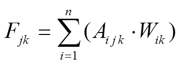
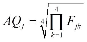
In the formula,Fis the comprehensive evaluation score of No. kcriterion layer of evaluation unit j;Ais the standardized score for No. i valuation indicator of No. k criterion layer;Wis the weight for No. i valuation indicator of No. k criterion layer, andis the valuation indicator of No. k criterion layer.
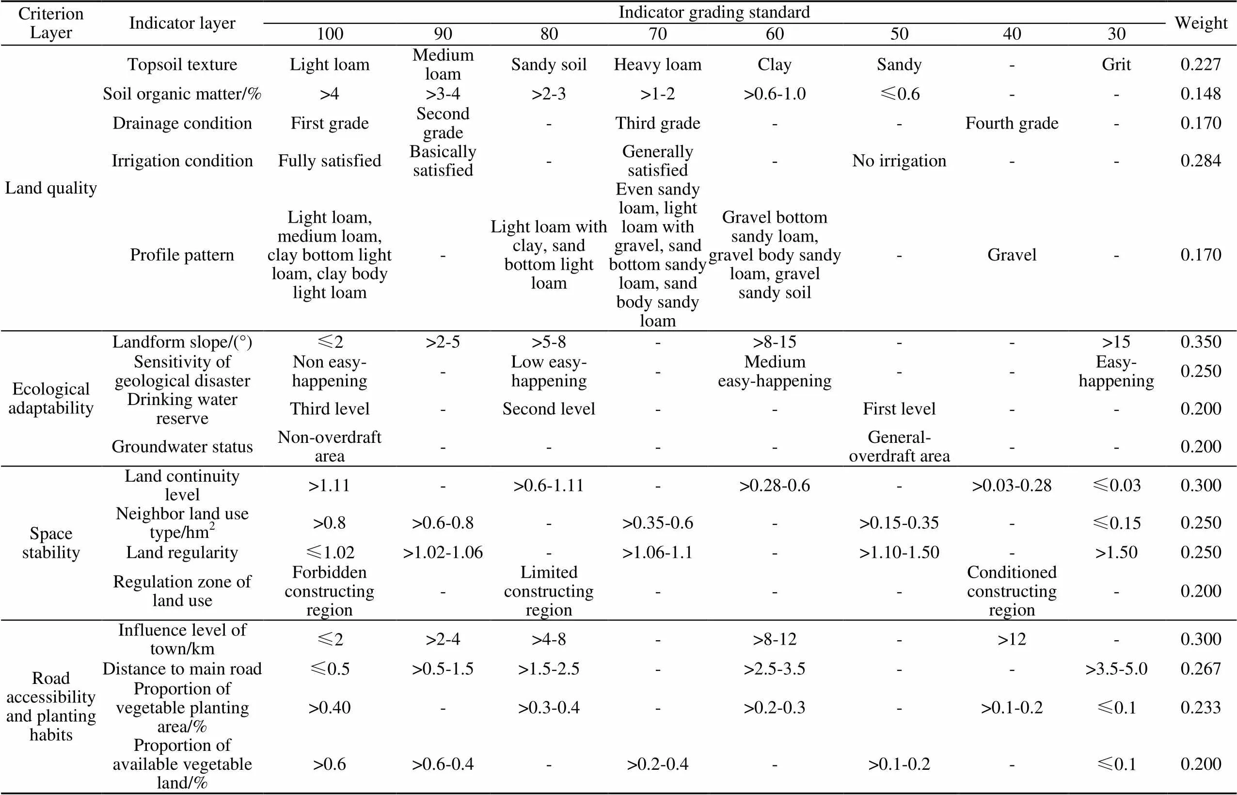
Table 1 Index weights, classification standardizations and scores in basic vegetable land quality evaluation
2 Results and analysis
2.1 Evaluation results of criterion layer
The quality score of land in Pinggu District is between 62 and 97 points (Fig.2a). Among them, the land with 86 points and above are mainly distributed in the south and north of Jinhaihu Town and Machangying Town featuring with flat land, deep effective soil layer, moderate soil texture of plowed layer, ideal farmland facilities, high-quality land, which are suitable for vegetable cultivation.
The score of ecological adaptability is between 55 and 100 points (Fig.2b), and land with higher points are mainly distributed in the west, northwest and south of Pinggu new town and concentrated in the third-grade drinking water conservation district and underground water non-overdraft area, featured with flat land and fewer geological disasters. The arable land patches that are scattered in mountain area with high incidence of geological hazards in Pinggu District and plain area with large slope gets very low score and some are even below 65, possessing weaker ecological suitability.
The score of space stability is from 29 to 96 points (Fig.2c), presenting a distribution pattern of “high in the south and west, low in the north and east”. Most land in Xiagezhuang Town and Donggaocun Town is of high regularity and connect with each other closely, located in the construction forbidden area of land use and governance zoning, so their space stability is higher than that in other areas.
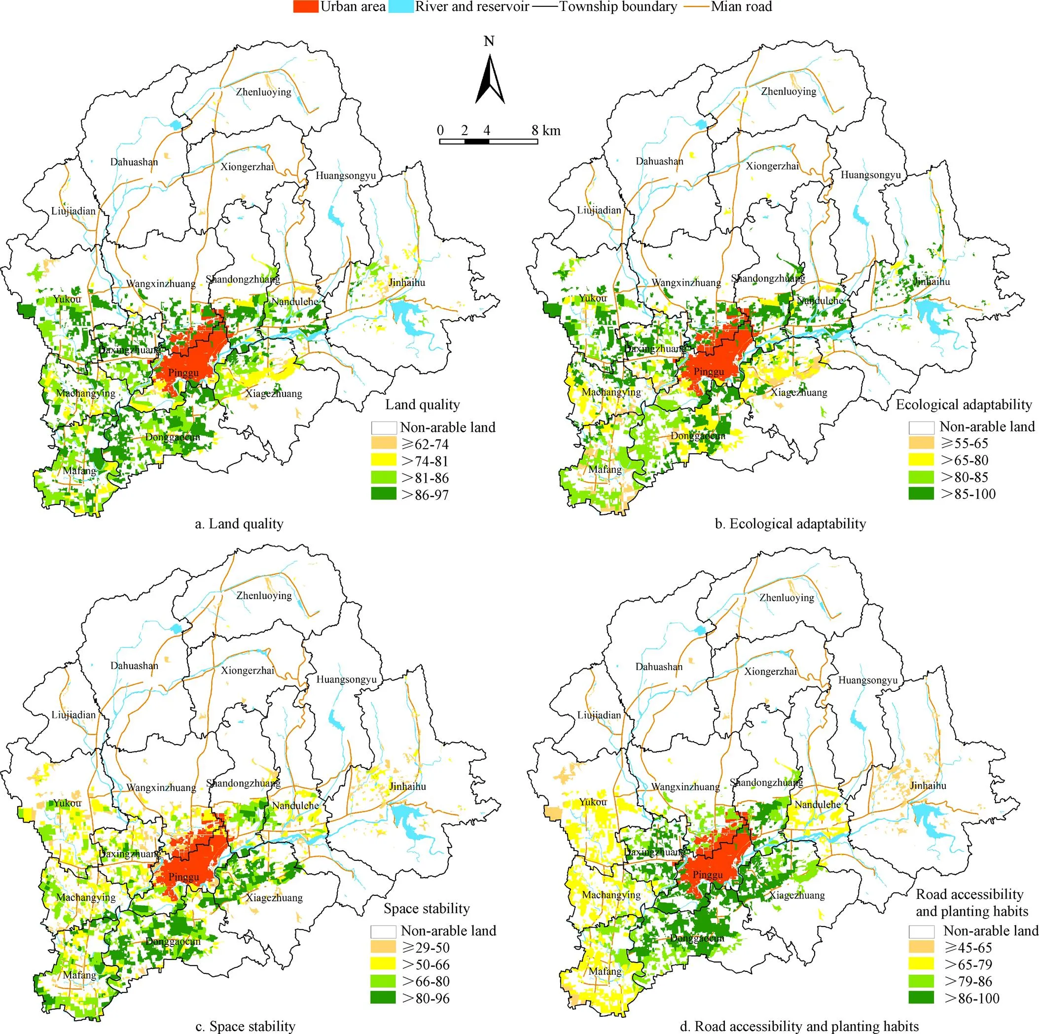
Fig.2 Results of criteria layer indicators in Pinggu District
The score of road accessibility and planting habit is from 45 to 100 points (Fig.2d), and fields with 86 points and above are mainly distributed in villages and towns around Pinggu Town that are closed to the Pinggu new town, featuring with convenient transportation and habit of vegetable cultivation; yet fields in Yukou Town, Machangying Town and Mafang Town get lower points. Above all, Donggaocun Town and Xiagezhuang Town enjoy abundant agricultural resource and long vegetable cultivation history, and show obvious advantages driven by large-scale vegetable-specialized villages and agricultural park with high-level facilities.
2.2 Comprehensive quality evaluation of vegetable land
The comprehensive valuation scores of arable land patches in Pinggu District were calculated based on equation (2), and then the arable land patches were divide into 4 types of areas (Fig.3) by Natural Breaks (Jenks) method in ArcGIS10.2 based on the calculation results.
2.2.1 Most suitable area
This area has comprehensive evaluation scores above 82, covering an area of 3 472.33 hm2, which accounts for 28.25% of total arable area in Pinggu District; the average area of arable land patches is 6.19 hm2, which has the largest average area of arable land patch. This type of arable land is mainly distributed in the south and east of Pinggu new town, especially in Donggaocun Town and Xiagezhuang Town. Considering the soil texture of plowed layer in arable land, the thickness of effective soil layer and soil profile construct, they are suitable for vegetable planting, and the irrigation infrastructures are favorable as well; for the gentle slope of arable land, extremely low incidence of geological hazards, concentrated distribution and regular shape, the land is suitable for large-scale cultivation. In addition, this area has obvious location advantages such as that the arable land is close to Pinggu new town and major roads, and far away from emergency water source region. Moreover, the land also belongs to the third-grade region of Pinggu drinking water conservation district, which are the firstly assigned area of basic vegetable land.
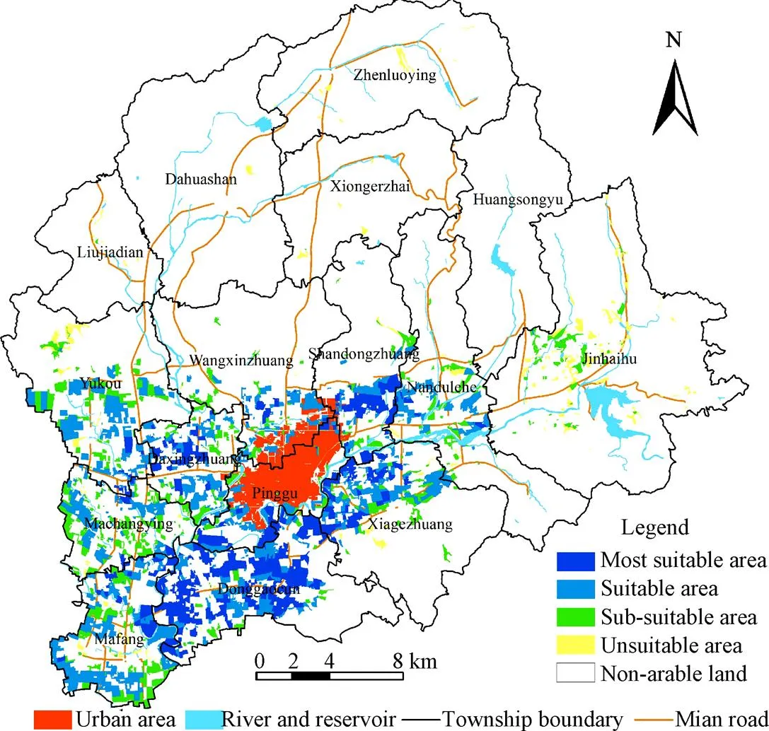
Fig.3 Classification of basic vegetable land in Pinggu District
2.2.2 Suitable area
This type of arable land has comprehensive evaluation scores between 75 and 82, covering an area of 5 186.28 hm2, which accounts for 42.19% of total arable land area in Pinggu District; the average area of arable land patch is 5.93 hm2, ranking only second to that in the most suitable area. This type of arable land is generally distributed in northeast of new Pinggu District and some villages in southwest, mainly including Yukou Town, Machangying Town, Mafang Town and Xiagezhuang Town. The arable land is featured with parcels in high quality and fine regularity, low incidence of geological hazards and convenient transportation, and also close to second-grade water reservation region. Compared with the most suitable area, this type of area has less grouped parcel and is further away from Pinggu urban area, which could be taken as the second choice of basic vegetable land.
2.2.3 Sub-suitable area
This type of arable land has comprehensive evaluation scores between 67 and 75, covering an area of 2 860.86 hm2; the average area of arable land patches is small, only 5.12 hm2. This type of arable land is distributed around the suitable area, but more scattered, which mainly includes Jinhaihu Town, Wangxinzhuang Town, Yukou Town, Machangying Town and other towns. This area possesses larger gradients that requires more work for land-leveling, poor access and land regularity, which goes against large-scale cultivation. Plus the inconvenient transportation and distance from Pinggu new town and Beijing urban areas, receiving a lower comprehensive evaluation score, which could only be used as the back-up area for basic vegetable land.
2.2.4 Unsuitable area
This type of arable land has comprehensive evaluation score of less than 67, covering an area of 773.91 hm2, and the average area of arable land patch is much less than that in other type areas, distributing mainly in Jinhaihu Town, Xiong’erzhai Town, Zhenluoying Town, Dahuashan Town and other towns with higher terrain, which is highly scattered in spatial distribution. These areas possess high incidence of geological hazards, poor topsoil texture, low organic content, far distance from Pinggu new town, inconvenient transportation and other unfavorable factors, which should not be used as basic vegetable land.
The grading result of the comprehensive quality evaluation is consistent with the plans for the vegetable industry described in the “Development Program of Modern Agriculture in Pinggu District in the ‘Twelfth Five-year Plan’ Period”. Moreover, this research is conducted based on the arable land patches in the “Land Use Status Database of Pinggu District in 2012”, which is more beneficial to the division of the basic vegetable land.
2.3 Differentiated construction of the basic vegetable land
Basic vegetable land in metropolitan suburbs has the dual function of guaranteeing vegetable supply for the local region and supplying commercial vegetable for urban residents[11,13]. Therefore, basic vegetable land in Pinggu District is designated based on the evaluation results of the comprehensive quality of land as well as the existing layout of greenhouse vegetable and the development orientation of the social economy, and the basic vegetable land in Pinggu District shall be divided into 3 levels: city-level basic vegetable land mainly supplies fresh vegetables for Beijing city; district-level basic vegetable land mainly guarantees vegetable supply for Pinggu new town and Pinggu development zone, and town-level basic vegetable land mainly ensures local vegetable supply.
As for the city-level and district-level basic vegetable land, with the construction of “Non-Staple Food Project”, efforts should be made to improve the emergency reserve base construction of vegetable for the city through such comprehensive measures as optimizing the seed quality and enhancing the scientific management of vegetable farmers; with the objective of high production, high quality, high efficiency, ecology and safety, accelerate the modernization and restructuring of low-efficiency vegetable land by new management entities, to build high-quality vegetable industry with good structure, complete functionality, safety and reliability. There also needs to mechanize greenhouse vegetable production, popularize new vegetable breeds and new planting modes suitable to mechanized operation so as to create a modern production base for vegetables. It is also important to collect vegetable production information to enable integrated management of vegetable production, supply and marketing.
In the town-level basic vegetable land, effort should be exerted to increase the scale production of vegetables in major villages and to cultivate a regional vegetable production base with high-quality characteristics. Meanwhile, construct a batch of high-standard, high-level, high-grade and ecological urban vegetable gardens that integrate the functions of tourism, sightseeing, relaxation, experience and picking, so as to supplement local tourist attractions and famous scenic spots, as well as to increase the additional value of products.
3 Conclusion and discussion
This research provides a comprehensive quality evaluation method of the basic vegetable land in the metropolitan suburbs under a new background. The method has been demonstrated in the Pinggu District, and the main conclusions are as follows:
1) The evaluation model for the designation of basic vegetable land in Pinggu has 17 indicators from 4 aspects, which fully takes the basic need of vegetable production for arable land quality into account, reflecting the requirements of the country and Ministry of Agriculture on the basic vegetable land.
2) The arable land patches in Pinggu district are divided into 4 types based on the evaluation result of the comprehensive quality of arable land. Most suitable area is 3 472.33 hm2, accounting for 28.25% of total arable area in Pinggu District, and is the prior choice of the basic vegetable land in Pinggu. The relatively suitable area ranks the second, covering an area of 5 186.28 hm2, accounting for 42.19% of the total arable area. The arable land in the sub-suitable area can be used as the reserved area for basic vegetable land. For the high incidence of geological hazards, poor topsoil texture, low organic content, far distance from Pinggu new town, inconvenient transportation and other unfavorable criteria, the arable land in unsuitable area should not be used as basic vegetable land.
3) It is suggested that by focusing on the construction of a “Non-Staple Food Project” in Beijing, the government’s construction and protection of basic vegetable production forms a coordinated policy with outdoor vegetable production, availability of fresh vegetables and a green environment complementing each other.
As most metropolitan suburbs are close to industrial areas and trunk roads, they are vulnerable to the “three pollutants” generated by plants and mines, daily-life waste in city, pesticide and chemical fertilizer, etc. Pollution problems faced by soil and the groundwater system it is closely related to may affect the safe production of vegetables greatly. This research does not include the environmental quality index of arable land because of limited data information. Furthermore, long-term excessive use of chemical fertilizer speeds up the deterioration of soil, while applying organic fertilizer can improve soil structure and vegetable quality, thus the availability of organic fertilizer is an important index that should also be considered during the arrangement of basic vegetable field. Hence, as data resource increases, research deepens and technical means improves, establishing a more comprehensive and systematic evaluation index system for the designation of basic vegetable land is the key point for the further research. Moreover, how to balance the centralized layout and dispersed production of vegetable, in other words, how to balance vegetable supply from outside the region and self-supply inside the region, also remains to be further considered.
[1] McClintock N, Cooper J, Khandeshi S. Assessing the potential contribution of vacant land to urban vegetable production and consumption in Oakland, California[J]. Landscape and Urban Planning, 2013, 111(1): 46-58.
[2] Fan Longji, Mu Yueying, Fu Wenge, et al. Vegetable growers’ willingness to give up and its influencing factors: A survey from five northern provinces in China[J]. On Economic Problem, 2015(4): 98-104.
[3] Zhao Xia, Mu Yueying, Li Xiaolin. Development trend of vegetable industry in Beijing since 2000[J]. Chinese Vegetable, 2011, 5: 7-10.
[4] Guo Hua, Cai Jianming, Wang Degen. Analysis of tempo-spatial patterns of Beijing external vegetable supply and its effects under massive logistical system[J]. Economic Geography, 2012, 32(3): 96-101.
[5] Erenstein O, Sumberg J, Oswald A, et al. What future for integrated rice-vegetable production systems in West African lowlands?[J]. Agricultural Systems, 2006, 88(2/3): 376-394.
[6] Francisco S R, Ali M. Resource allocation tradeoffs in Manila’s peri-urban vegetable production systems: An application of multiple objective programming[J]. Agricultural Systems, 2006, 87: 147-168.
[7] Rego L F G. Urban vegetable production for sustainability: The Riortas project in the city of Rio de Janeiro, Brazil[J]. Habitat International, 2014(44): 510-516.
[8] Zhao Depei, Zhong Xiaobo, Zhang Jizeng. On the vegetable production layout in China[J]. Scientia Agricultura Sinica, 1993, 26(6): 17-23.
[9] Wu JianZhai, Shen Chen, Wang Shengwei, et al. Spatial evolution, mechanism, effect and policies of vegetable production agglomeration in china[J]. Scientia Agricultura Sinica, 2015, 48(8): 1641-1649.
[10] Ji Long, Li Chongguang, Zhang Shengyong. The spatial distribution of vegetable production in China and its impact on vegetable price volatility[J]. Economic Geography, 2016, 36(1): 148-155.
[11] Xie Ruiwu. Practical exploration on promoting ‘Shopping Basket Program’ in central megacities: A case study of Chengdu City[J]. Issues in Agricultural Economy, 2015(7): 97-101.
[12] Dong Xiuru, You Mingying, Wang Qiubing. Demarcating method of prime farmland based on land evaluation[J]. Transactions of the Chinese Society of Agricultural Engineering (Transactions of the CSAE), 2011, 27(4): 336-339.
[13] Ren Yanmin, Tang Xiumei, Liu Yu, et al. Demarcating method of prime farmland considering ecological quality of cultivated land[J]. Transactions of the Chinese Society of Agricultural Engineering (Transactions of the CSAE), 2014, 30(24): 298-307.
[14] Feng Ting, Zhang Fengrong, Li Can, et al. Spatial distribution of prime farmland based on cultivated land quality comprehensive evaluation at county scale[J]. Transactions of the Chinese Society of Agricultural Engineering (Transactions of the CSAE), 2014, 30(1): 200-210.
[15] Zhou Yingheng, Lv Chao, Zhou De. Analysis of the influencing factors of the formation of main vegetable production areas in China: A case study of Shouguang in Shandong Province[J]. Geographical Research, 2012, 31(4): 687-700.
[16] Huong P T T, Everaarts A P, Neeteson J J, et al. Vegetable production in the Red River Delta of Vietnam. II. Profitability, labour requirement and pesticide use[J]. NJAS-Wageningen Journal of Life Sciences, 2013, 67(51): 37-46.
[17] Midmore D. Supplying vegetables to Asian cities: Is there a case for peri-urban production?[J]. Food Policy, 2003, 28(1): 13-27.
[18] Jiang Guanghui, Zhang Ruijuan, Zhang Cuiyu, et al. Approach of land use zone for capital farmland protection based on spatial agglomeration pattern and boundaries modification[J]. Transactions of the Chinese Society of Agricultural Engineering (Transactions of the CSAE), 2015, 31(23): 222-229.
[19] Ren Yanmin, Sun Jiulin, Liu Yu, et al. Delineation method of permanent basic farmland on county scale[J]. Transactions of the Chinese Society for Agricultural Machinery, 2017, 48(4): 135-141.
[20] Lv Meiye, Wang Kai. Effect of vegetable resources on planting and planting scale selection behavior: Based on the empirical analysis of Jiangsu Province farmers[J]. Journal of Agrotechnical Economics, 2008, 2: 64-71.
[21] Fan Longji, Mu Yueying, Fu Wenge. Analysis of influencing factors of vegetable production in big cities: Based on the survey of 196 vegetable growers in Beijing[J]. The World of Survey and Research, 2012(12): 17-20.
[22] Qi Yuanjing, Tang Chong. Effect of labor migration on cultivated land planting structure in rural China[J]. Transactions of the Chinese Society of Agricultural Engineering (Transactions of the CSAE), 2017, 33(3): 233-240.
[23] Tan Jianguo, Lu Xian, Yang Xingwei. Application of GIS to the evaluation of vegetable production resources and its rational arrangement in shanghai[J]. Quarterly Journal of Applied Meteorlolgy, 1999, 10(1): 112-117.
[24] Rashti M R, Wang W, Moody P, et al. Fertiliser-induced nitrous oxide emissions from vegetable production in the world and the regulating factors: A review[J]. Atmospheric Environment, 2015: 225-233.
[25] Li C, Chen J, Wang J, et al. Occurrence of antibiotics in soils and manures from greenhouse vegetable production bases of Beijing, China and an associated risk assessment[J]. Science of the Total Environment, 2015, 521/522: 101-107.
[26] Ren Y M, Yang Y X, Pan Y C, et al. Study on cultivated land concentrated areas delineation based on GIS and mathematical morphology: A case of Miyun county and Pinggu district in Beijing[M]// Computer and Computing Technologies in Agriculture VI. Springer Berlin Heidelberg, 2013: 376-383.
[27] Ren yanmin, Tang Xiumei, Liu Yu, et al. Layout method of cereal field based on production-ecology-location in Metropolitan Area[J]. Transactions of the Chinese Society for Agricultural Machinery, 2016, 47(5): 321-327.
[28] Marquez L O, Smith N C. A framework for linking urban form and air quality[J]. Environmental Modelling & Software, 1999, 14(6): 541-548.
[29] Huong P T T, Everaarts A P, Neeteson J J, et al. Vegetable production in the Red River Delta of Vietnam. I. Opportunities and constraints[J]. NJAS Wageningen Journal of Life Sciences, 2013, 67(51): 27-36.
[30] General Administration of Quality Supervision, Inspection and Quarantine, Standardization Administration of the People’s Republic of China. Regulations for classification on agriculture land: GB/T28405-2012[S]. Beijing: China Standard Press, 2012.
[31] Wang Shiyao, Wang Shujin. Empirical analysis of farmers’ decision-making behavioral factors in the change of vegetable planting area in Chinese Provinces[J]. Economic Geography, 2013, 33(9): 128-134.
[32] Lv Chao, Zhou Yingheng. The analysis of influencing factors of vegetables’ sown area in China[J] Economic Geography, 2011, 31(1): 118-122.
[33] General Administration of Quality Supervision, Inspection and Quarantine, Standardization Administration of the People’s Republic of China. Regulation for gradation on agriculture land quality: GB/T28407-2012[S]. Beijing: China Standard Press, 2012.
城市郊区耕地入选基本菜田的综合质量评价
刘 玉1,2,潘瑜春1,2※,任艳敏1,2,胡月明3
(1. 北京农业信息技术研究中心,北京 100097; 2. 国家农业信息化工程技术研究中心,北京 100097;3. 华南农业大学信息学院,广州 510642)
合理划定基本菜田是提升蔬菜生产能力、保障城市蔬菜均衡供应的基础。该研究在界定基本菜田内涵的基础上,构建平谷区耕地入选基本菜田的综合质量评价模型,以期为大城市郊区基本菜田布局提供科学依据。结果表明:1)从田块质量、生态适宜性、空间稳定性、交通区位与蔬菜种植习惯等4方面构建耕地入选基本菜田的综合质量评价指标体系,充分考虑了蔬菜生产对耕地质量的基本需求以及国家和农业部对基本菜田的政策要求,包含了水资源供需状况和重要水源保护区等指标,使得该研究的评价方法更合理;2)平谷区耕地的田块质量、生态适宜性、空间稳定性、交通区位与蔬菜种植习惯等评价结果呈现差异性分布。基于综合质量评价结果,将平谷区耕地图斑划分为最适宜区、较适宜区、一般适宜区和不适宜区。其中,最适宜区是基本菜田的首选区域,主要分布在平谷新城周边的东高村镇、夏各庄镇、山东庄镇和大兴庄镇,面积为3 472.33 hm2,占平谷区耕地总面积的28.25%;其次是较适宜区,面积为5 186.28 hm2;一般适宜区的面积为2 860.86 hm2,可作为基本菜田储备区域;不适宜区的土壤表土质地差、有机质含量低,加之远离平谷新城、交通不便等因素,不适宜划为基本菜田。3)建议围绕首都“菜篮子工程”建设,强化基本菜田的分级建设与保护,形成露地蔬菜、设施蔬菜和蔬菜园区相互补充的蔬菜生产格局。
土地利用;评价;模型;基本菜田;空间布局;平谷区
10.11975/j.issn.1002-6819.2017.17.036
F323.211
A
1002-6819(2017)-17-0271-09
2017-05-19
2017-08-24
The Science and Technology Innovation Capacity Building Project of Beijing Academy of Agriculture and Forestry Sciences (KJCX20170503); National Natural Science Foundation of China (41201173)
Liu Yu, Ph. D, associate professor, majoring in land use, regional agriculture and rural development. Email: Liuyu@nercita.org.cn
Pan Yuchun, researcher, majoring in spatial analysis and distributed geographic information system (GIS). Email: Panyc@nercita.org.cn

