Application of an Artificial Neural Network for a Direct Estimation of Atmospheric Instability from a Next-Generation Imager
Su Jeong LEE,Myoung-Hwan AHN,and Yeonjin LEE
Department of Atmospheric Science and Engineering,Ewha Women's University, 52 Ewhayeodae-gil,Seodaemun-gu,Seoul 120-750,Republic of Korea
Application of an Artificial Neural Network for a Direct Estimation of Atmospheric Instability from a Next-Generation Imager
Su Jeong LEE,Myoung-Hwan AHN∗,and Yeonjin LEE
Department of Atmospheric Science and Engineering,Ewha Women's University, 52 Ewhayeodae-gil,Seodaemun-gu,Seoul 120-750,Republic of Korea
Atmospheric instability information derived from satellites plays an important role in short-term weather forecasting, especially the forecasting of severe convective storms.For the next generation of weather satellites for Korea's multi-purpose geostationary satellite program,a new imaging instrument has been developed.Although this imaging instrument is not designed to perform full sounding missions and its capability is limited,its multi-spectral infrared channels provide information on vertical sounding.To take full advantage of the observation data from the much improved spatiotemporal resolution of the imager,the feasibility of an artificial neural network approach for the derivation of the atmospheric instability is investigated. The multi-layer perceptron model with a feed-forward and back-propagation training algorithm shows quite a sensitive response to the selection of the training dataset and model architecture.Through an extensive performance test with a carefully selected training dataset of 7197 independent profiles,the model architectures are selected to be 12,5000,and 0.3 for the number of hidden nodes,number of epochs,and learning rate,respectively.The selected model gives a mean absolute error, RMSE,and correlation coefficient of 330 J kg-1,420 J kg-1,and 0.9,respectively.The feasibility is further demonstrated via application of the model to real observation data from a similar instrument that has comparable observation channels with the planned imager.
CAPE,artificial neural network,instability,geostationary imager
1.Introduction
The prediction of severe weather phenomena,such as tornado-producingthunderstorms,withasufficientlead-time, is one of the most important tasks for operational weather forecasting.Theobjectiveanalysisofthepre-convectivestate of the atmosphere is quite an important task for that purpose.Several indices representing atmospheric instability, such as“Lifted index”,“K-index”,“Showalter index”,“Total Totals”,and CAPE,have long been used(Koenig and de Coning,2009;Botes et al.,2012).These indices are usually derived using the vertical profiles of temperature(T)and humidity(q)obtained from radiosonde observations or the outputs from a numerical weather prediction(NWP)model. However,as radiosonde data are obtained only twice a day at a limited number of observation stations,their spatial and temporal resolutions are limited.Such limitations are severe for a large portion of the globe,including the vast area of the ocean and even over large areas of land.To supplement these limitations,high resolution atmospheric instability indicesderived from satellite observations have long been utilized (Kitzmiller and McGovern,1989;Menzel et al.,1998;Li et al.,2012).
Satellite-derivedinstability indices are normally obtained from the vertical T and q profiles derived from the radiances measuredbysoundinginstrumentsonboardeithergeostationary or polar orbiting satellites(Menzel et al.,1998;Botes et al.,2012;Li et al.,2012),or by pseudo-sounders onboard geostationary satellites(EUMETSAT,2013),using statistical (Seemann et al.,2003),physical iterative(Ma et al.,1999), or variational(Koenig and de Coning,2009)methods.Each observation platform and derivation method has its own advantages and disadvantages.For example,the data from the hyper-spectral sounding instruments onboard the polar orbiters provide the most accurate vertical profiles,although their spatial and temporal resolutions are limited to about 30 km and only twice a day,respectively.On the other hand,the geostationary platform provides a limited accuracy of vertical profiles but with much better spatial and temporal resolutions.For example,the 12-channel Spinning Enhanced Visible and Infrared Imager(SEVIRI)onboard the Meteosat Second Generation(MSG)satellite provides the global instability index(GII)every 15 minutes with spatial resolutions of15×15 pixels(corresponding to about 50 km×50 km)for operation,or 3×3 pixels for the rapid scan service(Koenig and de Coning,2009).In terms of retrieval,the physical iteration or variational approach is known to outperform the statistical approach,althoughits processingtimeis muchlonger.
©Institute of Atmospheric Physics/Chinese Academy of Sciences,and Science Press and Springer-Verlag Berlin Heidelberg 2016
Here,we introduce a new approach to obtain an instability index,which is developed for a planned series of high performance imagers onboard geostationary satellites,expected to be available as early as in 2015.One of the imagers,the Advanced Meteorological Imager(AMI)will be onboardGK-2A(GeostationaryKoreaMultipurposeSatellite 2A),the follow-on mission of the current COMS(communication,ocean,and meteorological satellite)program(Kim and Ahn,2014),and is scheduled to launch in 2018.With the significant improvement of spectral coverage(from the current five channels to sixteen channels,including ten infrared channels),a host of new value-added products,including instability indices,are expected to be produced.Furthermore, as the spatial resolution of the infrared channels will be improvedtwofold(from 4 km to 2 km),along with the temporal resolution(from 30 minutes to about 10 minutes for the full disk coverage),the available information will increase dramatically.On the other hand,with these improvements,the data volume and burdens for prompt data processing are expected to be significantly increased.
The new approach is geared toward dealing with this issue,by applying an artificial neural network(ANN)algorithm to derive the instability index directly from the measured radiance(or the brightness temperature,Tb),instead of using the retrieved T and q profiles(Koenig and de Coning, 2009;EUMETSAT,2013).The current algorithm for geostationarysatellites,suchas GeostationaryOperationalEnvironmentalSatellite(GOES)Sounders(Jin et al.,2008),produces products with acceptable accuracy by combining observed radiances with NWP forecasts.Furthermore,it is known that most physical iteration or variational approaches converge to a solution within a few iterations,which increases the feasibility for operational applications.However,these approaches require appreciable computation time,which in turn requires certain compromises,such as reduced spatial or temporal resolution of the original observation data(Menzel et al.,1998;KoeniganddeConing,2009).On theotherhand, arecentstudybyLietal.(2012)assertedthatsatellite-derived stability index is much more useful if the spatial resolution is improved.Also,the improved temporal resolution on the geostationary platform could be better utilized if the derived information is available as soon as the observation data are available.Thus,our choice of the ANN algorithm is to derive the instability index with minimum time delay,and without compromising spatiotemporal resolution.Furthermore,the ANN algorithm could be utilized for cases when high performance NWP data are not available,and has high potential for application to hyperspectral sounding instruments(Liu et al., 2014).However,it should be mentioned here that the sounding informationcontainedwithin the measuredradiancefrom the geostationaryimager is limited,and thus the feasibility of the derived instability index should be carefully validated before real-time application(Martinez et al.,2007).
Thepaperis organizedas follows:Section2describesthe specification of the new imaging instrument,along with the preparation of training datasets for the ANN algorithm,including a radiative transfer model(RTM)used for the derivation of the theoretical radiance data with the inputted atmospheric information(i.e.,T and q profiles).Section 3 describes the ANN algorithm with the adopted training process andresultantalgorithmperformancewiththetraining.Insection 4,the application results with the actual observationdata and its validation are described.The paper concludes in section 5 with some suggestions for future improvements.
2.Data and methods
A feed-forward multi-layer perceptron(MLP)algorithm with the back-propagation training approach(Blackwell and Chen,2009)is adopted for the current study.To properly train the ANN algorithm,it is important to prepare a training dataset with the proper characteristics,such as accuracy, completeness,and comprehensiveness(Blackwell and Chen, 2009).Indeed,a previous study using the pre-sorted limited number of atmospheric profiles from TIGR(Thermodynamic Initial Guess Retrieval)has demonstrated the importance of the comprehensiveness of the training dataset(Lee et al.,2013).Thus,for the current study,the dataset has been augmented with the additional vertical profiles of T and q obtained from the satellite observation,to strengthen the representativeness.
The training dataset,consisting of input variables such as the measured radiance and viewing conditions,and the corresponding output variable(here,the CAPE value),is prepared by a theoretical approach.For example,the channel radiances are obtained by the convolution of the spectral radiances,[LIASI;see Eq.(1)],obtained from the RTM simulation with the appropriate T and q profiles from the IASI(Infrared Atmospheric Sounding Interferometer)Level 2(L2) data,with the appropriate boundary and viewing conditions. Here,we use the spectral response function[SRF,ϕGEO(ν)] of the geostationary(GEO)imager,i.e.,SEVIRI of MSG,for the latter application.

Here,we use the simulated LIASIinstead of the measured IASI Level 1B radiance to simulate the geostationary conditions,including various viewing angles,cloud-free radiances,and boundary conditions that the GEO imager would encounter.
Once the ANN algorithm is prepared,the optimal way to demonstrate the feasibility would be through the application of the algorithm to the real data.However,as the high performance imager data are not available over the AMI coverage area,we use data from SEVIRI onboard the MSG satellite as a surrogate.Also,as CAPE is the integration over a number of vertical layers and would not be very sensitive to thesounding accuracy of a specific level,as other instability indices would,we focus on CAPE with the expectation that it will properly represent the instability information contained in the planned observational channels.
2.1.AMI specification
The next generation imaging instrument for GK-2A is known to have much-improved overall capabilities in terms ofspatial,temporal,andspectralresolutions,comparedto the current five-channel imaging spectrometer onboard COMS (Kim and Ahn,2014).As summarized in Table 1,its spatial resolutionat the sub-satellite pointis 0.5km,1 km,and 2 km, for the high resolution visible,visible,and infrared channels, respectively,which is at least twofold better than the current imager.Furthermore,the time required to cover a full disk will be much shorter than the current capability of about 30 minutes,by at least threefold,requiring less than 10 minutes for the full disk imaging.Overall,the combined capability is estimated to be more than 30 times better(twofold in spatial, threefold in temporal,and fivefold in spectral terms)than the current instrument.
There are more interesting and important improvements in view of the atmospheric sounding in the increase of the number of infrared channels with the improved radiometric performance.For example,the water vapor channel will be increased from one channel to three channels,which contain the water vapor information for the lower,middle,and upper troposphere.Furthermore,there will be one new channel in the carbon dioxide absorption band of 13.3 μm,to obtain better temperature information in the upper to middle troposphere.With the combination of these absorption channelsand the infraredwindowchannelsand a prioriinformation from the NWP model,the instrument is expected to have equivalent or similar vertical pseudo-soundingproducts compared to the current sounding instruments onboard the U.S.GOES satellite(Schmit et al.,2008;Lee et al.,2014b). However,it should be noted here that the legacy sounding products could be generated with reduced spatial and temporal resolution to limit the computation time and to increase the signal-to-noise ratio(SNR)(Schmit et al.,2008)
2.2.Collection of T and q profiles and data filtering
With 8461 channels covering the infrared spectral range between 3.62 and 15.5 μm,the accuracies of T and q profiles derived from the IASI data(1 K for tropospheric temperature and 10%for humidity)are known to be comparable with those of radiosonde data(Hilton et al.,2012).Thus, IASI L2 T and q profiles in clear-sky conditions in our study domain,(35◦-75◦N,75◦W-75◦E),which corresponds to the rapid scan domain of Meteosat-8,are collected for the training dataset.
The CAPE values,which are the target products from the ANN algorithm,are calculated using the obtained IASI L2 profiles by integrating the potential temperature differences between the rising air parcel and the ambient air from the level of free convection to the equilibrium level.Normally, the CAPE calculation considers a parcel that is lifted from a well-mixed boundary layer,usually in the lowest 50 to 100 mb,not from the surface(Craven et al.,2002).However,as T andq profiles frombothTIGR andIASI L2 representa certain rangeof verticallayers,implyingthat the valuescouldbe considered as a layer mean value,we calculate CAPE using the T and q values at the ground,instead of taking average values of the lowest atmospheric layers.
For sufficient representativeness of the different seasons, IASI L2 T and q profiles are firstly collected from January to December 2012,including about 36 to 40 day and night orbits(or six days)each month.From the period,a total of 459 orbits and 42 025 individual profiles are selected,and then CAPE values are calculated from the profiles.We then filterthe collected data based on the calculated CAPE values,to acquire as comprehensive a dataset as possible.For this,we divide the collected data into three groups of CAPE values having“0 and 1000”,“1000 and 2000”and“above 2000”, andthiscategorizationrevealsthenaturalfrequencyofCAPE values(as shown in Table 2),with very high frequency of low CAPE values and relatively very low frequency of high CAPE values(i.e.,values above 2000,which indicates high instability in the atmosphere).To build up a more extensive training dataset that has sufficient representation at the higher end of the CAPE values,we decided to conduct a second round of data collection,adding more data(63 orbits and 21 852 profiles)taken from summer months.Finally,63 877 profiles are collected and 2399 profiles from each CAPE range,and a total of 7197 profiles are selected as the final dataset for the training of the neural network.
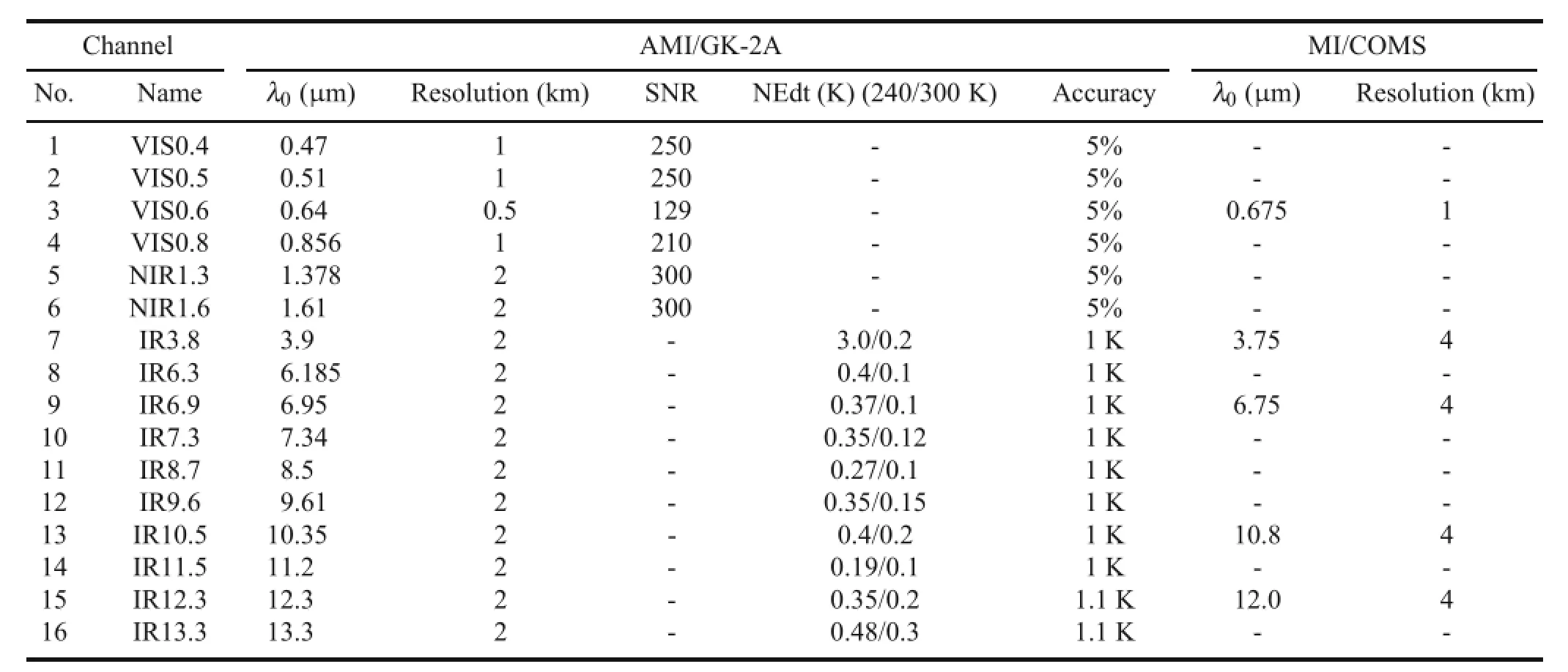
Table 1.Specification of the AMI of the next-generation GK-2A satellite,in terms of channel,center wavelength(λ0),spatial resolution, SNR,noise-equivalent delta temperature(NEdT),and calibration accuracy,along with the center wavelength and spatial resolution of the current meteorological imager(MI)onboard COMS.
Figure 1 shows the distribution of CAPE for the whole of the collected(left)and selected(right)profiles within the study domain.The whole dataset shows a relatively high frequency of low CAPE values(<1000 J kg-1)over most of the study domain,while a high instability toward the regions of southern Europe,between 40◦N and 50◦N,is evident both in all,and selected,profiles.This distribution agrees quite well with the general pattern of CAPE distribution obtained from the European Centre for Medium-RangeWeather Forecasts(ECMWF)40-Year Reanalysis(ERA-40) dataset,which shows high CAPE values over southern European countries under a dominant influence of the Mediterranean(Romero et al.,2007).Furthermore,Fig.1(right)includesan equalnumberofprofilesfromthreedifferentCAPE ranges,representing three different states of the atmosphere, i.e.,weak,moderate,and strong instability.
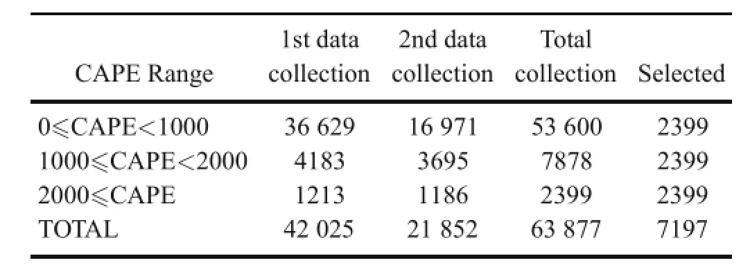
Table 2.Selected number of IASI profiles for ANN training binned by the CAPE range.
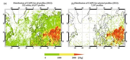
Fig.1.(a)CAPE distribution for the collected profiles in the study domain.(b)CAPE distribution for the selected 7197 profiles in the study domain(green:0-1000 J kg-1;yellow:1000-2000 J kg-1;orange:>2000 J kg-1).
2.3.Simulated Tb
To simulate the theoretical Tbfrom the selected 7197 T and q profiles,we use the most recent version of MODTRAN (MODerate resolution atmospheric TRANsmission,version 5.2.2),whichcoversspectral rangesfrom0.2to50000cm-1, with 0.2 cm-1resolution(Berk et al.,2011).Radiances are simulated over the spectral range from 600 to 3000 cm-1(16.67-3.33μm),with 1 cm-1resolution,foreach selectedT and q profile with the GEO viewing geometry.For the application of Eq.(1),the SEVIRI SRF,available at the EUMETSAT(EuropeanOrganisationfortheExploitationofMeteorological Satellites)website(http://www.eumetsat.int/website/ home/Data/Products/Calibration/MSGCalibration/index.html), is used.Finally,the simulated Tbis obtained by the inversion of the Planck function with the center wavelength of each broadband channel.For the independent variables used for the ANN training,Tbvalues from the seven infrared channels (6.2,7.3,8.7,9.6,10.8,12.0,and 13.4 μm),along with auxiliary parameters such as geographical location(latitude and longitude),time(converted to the circular type),and satellite zenith angle,are stored.
3.ANN algorithm and training
3.1.ANN algorithm
The MLP model has been widely applied in the geosciences,including the atmospheric sciences,such as in ar-eas of pattern recognition,prediction,and function approximation(Gardner and Dorling,1998;Krasnopolsky,2007; Taravat et al.,2015).The MLP model used for the current study consists of layers,neurons(or nodes),and connection strength between the nodes(called weights hereafter),and is schematically summarized in Fig.2.For the number of layers,we selected one input,one hidden,and one output layer, by taking into consideration the nature of complexity(Blackwell and Chen,2009).In the case of neurons,each layer consists of a different number,while it is relatively easy to determine the input layer(depending on the input variables). However,the neurons in the hidden layer play an important role in the ANN's performance and should be determined during the algorithm's development(see section 3.2 for further detail).On the other hand,the output layer has only one neuron,which combines all the weighted outputs from the hidden layer to produce the estimated value.
The MLP model used for the current study is a feedforward(the direction that the information moves)and backward propagation(the direction that the estimated error moves)approach.For the forward direction,the MLP model takes the independent input variables into the input layer and multiplies them by the respective weights,which are the matrix(rows of hidden layers and columns of the input variables).Each weighted input variables is summed and then fed into the hidden layer.In the hidden layer,each neuron activates the input signals using a transfer function,a hyperbolic tangent in our case.The outputs of the hidden layer are then multiplied by the respective weights(i.e.,the connection strength between the hidden neuron and the output neuron)and linearly summed up in the output layer to produce the estimated value to complete the forward transfer of the information.
The other direction of the MLP algorithm,i.e.,the backward direction,acts to propagate the error signal,which is obtainedby direct comparisonbetweenthe estimated and target value(the“truth”).This error propagation acts to update the weights that are used in the forwardpropagationusingthe errorsignal,and thus it correspondsessentially to the training of the ANN algorithm.The update is based on the steepest negative gradient with a fixed learning rate(Blackwell and Chen,2009),which can be expressed as

Fig.2.MLP model with three layers[xi:inputs;wij:weight (connection strength)between input neuron i and hidden neuron j;vj:weight between hidden neuron j and the output neuron; f:transfer function for the hidden neuron;y:the estimation].

Equation(2)states that the current weight(wij,c)is updated by taking into consideration the negative gradient of error (E)relative to each weight(wij)multiplied by a constant, γ,which determines the rate of adjustment(or the learning rate).The new adjusted weights(wij,n)are highly dependent on the sensitivity of the error to each weight and the learning rate value used.Thus,proper selection of the learning rate plays quite an important role in escaping the local minima and speeding up the training process(Blackwell and Chen, 2009),and the sensitivity is tested duringthe training process to find an optimal value for the current study.
3.2.ANN training
As shown above,any ANN model requires proper selectionof thenetworkarchitecture,suchas the numberoflayers, neurons,learning rate,and the epoch number.Thus,selection of an optimal combination of these network architecture components is the most important and time consuming process in the training of an ANN model.Following the general proceduresuggested by Lee et al.(2014a),we conducted an extensive performance test for the different combinations of network architectures,including the number of neurons, learning rate,and epoch number,to find an optimal combination.With different numbers of nodes(varying between 9 and 15),different learning rates(increasing from 0.05 to 0.95 with a step of 0.05),and different epoch numbers(from 1000 to 5000 with a step of 1000),a total of 665 combinations of network architectures have been tested.For the test, the training dataset is separated into three groups:a dataset for training(80%),testing(10%),and validation(10%).To prevent any over-fitting problems,we applied the early stopping strategy process(Gardner and Dorling,1998)with the RMSE value estimated with the validation dataset as the performanceindicator.Since the ANN algorithmselects random patterns(e.g.,80 out of 100)for each test-run,the RMSE values vary significantly from one case to another,even with the same combination of ANN parameters.Thus,as mentioned above,a number of tests were conducted to select the best result(minimum RMSE)from each combination.
Table 3 shows the resultant RMSE values from the different combinations of the numbers of neurons and epochs, with the learning rate of 0.3,which gives the best performance among the values tested.Based on the results,it is clear that the performance is quite sensitive to the selection ofnetworkarchitecture.Furthermore,the RMSE dependence on the selected architecture shows a quite erratic characteristic.For example,with the selection of 12 hidden neurons,the RMSE value shows a gradual decrease with increasing epoch number.However,when the number of hidden neurons is 14, the RMSE value increases with increasingepoch number.On theotherhand,whenthelargestnumberofepochsis selected, the RMSE value shows a strong variability with the differentnumberofneurons.Nevertheless,the RMSE performanceindicates that there is broad agreement on the minimum value of around 420 J kg-1.Thus,for the current study,we selected the combination of 12,5000,and 0.3,for the number of hidden neurons,the epoch number,and the learning rate, respectively.With this combination,the mean absolute error, RMSE,and cross correlation are 330 J kg-1,419.9 J kg-1, and 0.9,respectively.
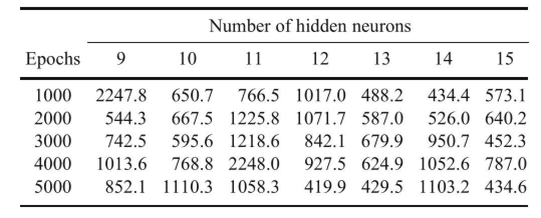
Table 3.RMSE between the ANN outputs and the test target CAPE with a varying number of hidden neurons and epochs(learning rate =0.3)(units:J kg-1).
4.Results
4.1.Feasibility test
The feasibility of the ANN algorithm for the real-world data is tested by using the actual data obtained during the rapid scan experiment(2.5 minute image acquisition)of SEVIRI conducted on 20 June 2013,when severe convective storms developed over large parts of Europe(Setv´ak and M¨uller,2013).Figure 3 shows the image sequence of the derived CAPE from the ANN algorithm(hereinafter ANN CAPE)overlaid over the background black and white image of the 10.8 μm Tbvalue(white represents cold clouds, while the dark area is the warm and clear area)at every two hours from 1000 UTC to 1600 UTC(the movie clip made of the retrieved ANN CAPE,with a temporal resolution of 5 min,is available as supplementary online material,entitled Video S1).In the morning hours,several places,such as over the eastern coastal area of Italy,the northern coastal area of Greece,and over Albania,Macedonia,and Bulgaria,show CAPE values of more than 2000 J kg-1.Also,there are large CAPE values along the leading edges of the convectivecloud over northern Germany.
Later on,as the time progresses,several convective clouds over the area where the CAPE values are high and the sky conditions are clear during the morning(black circles), begin to pop up at around 1200 UTC(Fig.3b).These clouds continue to develop into severe convective clouds in the afternoon hours(Fig.3c)and begin to weaken during the late afternoon(Fig.3d),showinganevolutiontypicalofa convective cloud system.On the other hand,the CAPE values along the leading edges of the developing clouds(red circles)are high for a narrow band,while the values at the trailing edges are much weaker.As time progresses,the convective clouds develop and move to the areas with high CAPE values,while the clouds are weakened over the trailing edge(progress of cloud development is clearly visible in the movie clip,Video S1).This kind of CAPE distribution along the developing convective clouds is also shown in the atmospheric instability derived from the sounding instrument onboard the U.S. GOES satellite(e.g.,Li et al.,2008,Fig.2;Lee et al.,2014b, Fig.9),which qualitatively demonstrate the feasibility of the ANN CAPE.Overall,in a qualitative sense,the ANN CAPE seems to be able to explain the general distribution of the actual atmospheric instability.
4.2.Validation
Here,we attempt to validate the ANN algorithm in terms of the qualitative and quantitative aspects,with the specific case introduced above.For the validation,the ANN CAPE is compared with several similar types of instability information,including the forecasted CAPE from the ECMWF model output(called NWP CAPE),the calculated CAPE using a limited number of radiosonde soundings(Sonde CAPE),and with other atmospheric instability indexes,such as K-index,which is operationally produced from MSG/SEVIRI(EUMETSAT,2013).
In the case of the NWP CAPE(Fig.4a),high instability values are well organized and widely distributed over the northern part of France to Germany,where the severe storm is located in the morning hours.With less strength,there is instability over southeastern parts of Europe,where severe thunderstorms developed later in the afternoon,as shown before(see Fig.3).Although it is not as strong as the other region,there is also a relatively unstable area in the lowermid part of Italy,where a single super-cell developed in the afternoon.In some pixels,however,the NWP CAPE is overestimated over the areas where no convective clouds developed(e.g.,Slovakia,parts of Austria,and Hungary),and also in cloudy pixels,such as in the northern part of France and Belgium(blue dashed circles).In addition,with the limited spatial resolution of the model(0.25◦×0.25◦),the finescale descriptionof the local-scale instability,as shown in the satellite-derived instability distribution(Fig.3b),is limited.
Comparisonwiththe productsfromthe SEVIRIGII gives a direct comparisonbetween the ANN retrieval and the physical iteration approach.While the GII products are provided every15minutesfor3×3MSGpixels(ora9km×9kmsegment size at the nadir),the ANN retrievals are with 1×1 pixels.Since CAPE is not included in the GII products,K-index was compared with the ANN CAPE instead.Although the different index scale of K-index(Fig.4c)and CAPE does not allow a direct quantitative comparison,a careful comparison (Figs.4b and c)reveals a closer similarity in the spatial distributionsofbothindices,withafewevidentdifferencesinview ofthe absolutemagnitudeandexactdistribution.While MSG K-index captures the overall instability over Germany well, the ANN products,with higher spatial resolution,are capable of capturing the instability information around cloud edges, e.g.,over the northwestern part of Poland(red dashed circle in Fig.4c)and the rapidly evolving features of small convective cells,as also normally shown for developing super-cell thunderstorms(Li et al.,2008;Lee et al.,2014b).
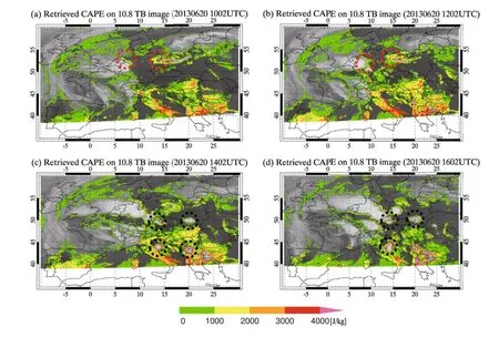
Fig.3.Sequence of derived CAPE from SEVIRI 2.5 min rapid scan data using the ANN algorithm[displayed every 2 h from 1000 to 1600 UTC:panels(a)to(d),respectively].The high CAPE values at the leading edges of the developing thunderstorm (red circles)show a continuous development and movement of the developing clouds,while the black circles in(c)represent convective clouds developing later in the afternoon from the clear-sky condition in the morning.
The CAPE distribution from the limited number of radiosonde station data obtained from the University of Wyoming(Oolman,2014),is shown in Fig.4d.Overall,the areas with high instability are well matched with the high CAPE values from both the ECMWF forecast and ANN algorithm.Forexample,thestrongconvectivestormthatdeveloped over central Europe is led by high Sonde CAPE,which is also shown in NWP CAPE and ANN CAPE.However,due to the limited spatial coverages,several unstable areas,such as over Italy and central Europe,are not captured well by the radiosonde observation.Although it is limited,a quantitative comparison is also made with the radiosonde data available during the time period(1130-1200UTC),and the results are summarized in Table 4.For the comparison,the high resolution ANN CAPE(about 0.03◦×0.03◦,2.5 min interval)is averaged spatially(within the 0.5◦×0.5◦grid-box)and temporally(for 30 min).The limitation in the quantitative validation lies in the scarcity of radiosonde data(e.g.,only 44 out of 76 stations have CAPE values at 1200 UTC)and the small number of matches between the retrieved CAPE and that fromradiosonde.Forexample,the highANN CAPE values along the northeastern coast of Italy(Fig.4b,red dashed circle)are not validated due to the vacancy of observation (see Fig.4d).Furthermore,the scarcity of radiosonde stations around the area of convective development,particularly the Mediterranean,including Greece,Bulgaria,and Serbia, limits a comprehensive comparison.
Even with these limitations,Table 4,which compiles the cases when a sufficient number of retrieved ANN CAPE pixels are available within each comparison grid-box,shows some characteristics of the ANN CAPE.For example,the area-and time-averaged ANN CAPE values are generally much smaller than the collocated Sonde CAPE values,except for a few cases,such as station number 16 080.There are a number of factors that could be considered as the cause of the difference between the two CAPE values.One of the most plausible causes of the difference lies in the limited vertical sounding capability of SEVIRI,especially for the lower atmosphere,both in the amount of information content and its vertical resolution(Jin and Li,2010).As the accuracy of CAPE estimation is highly sensitive to the lower boundaryof the atmosphere(Craven et al.,2002;Zhang,2002),the lack of information content of SEVIRI for this atmospheric layer could introduce considerable uncertainty.Another possible source for the difference could be introduced by the sampling problem,i.e.,the comparison process itself includes several uncertainties,such as the spatial co-location process [radiosondes drift~5 km in the midtroposphere,~20 km inthe upper troposphere,and~50 km in the lower stratosphere (Seidel et al.,2011)],and time difference(within one hour). Finally,the satellite signals vertically smoothed by the averaging kernels could reduce the large variability in the vertical T and q distribution,consequently reducing the estimated CAPE value.

Fig.4.(a)ECMWF-forecasted CAPE.(b)ANN CAPE.(c)K-index retrieved from MSG SEVIRI(blank lines indicate missing row data,obtained from the EUMETSAT Data Center).(d)CAPE value derived from the radiosonde observation at 1200 UTC.

Table 4.Comparisons of CAPE derived from radiosonde and ANN CAPE averaged over space and time of a 0.5◦×0.5◦grid-box and 30 min,respectively.STD denotes the standard deviation of the mean CAPE value.
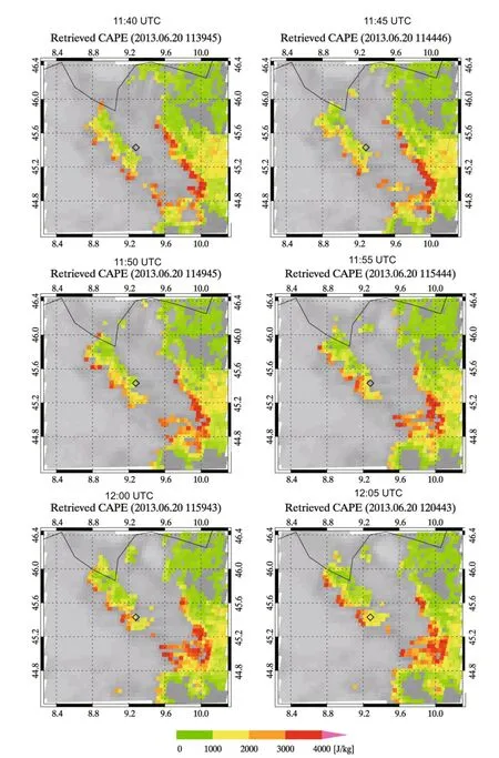
Fig.5.Time series of the derived ANN CAPE values for a limited area[2◦×2◦box centered at radiosonde station 16080(black diamond)]at a time interval of~5 min centered at 1200 UTC.
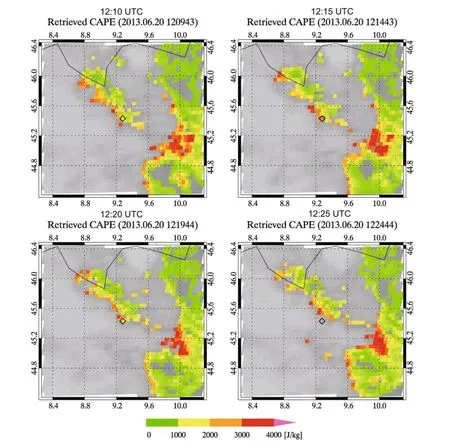
Fig.5.(Continued.)
Another characteristic of the ANN CAPE is that it shows a large variability even within the small grid-box,having standard deviation ranging from 250 to 760(Table 4),which might represent the actual spatial variability of the atmospheric instability.To check the spatiotemporal variability of the ANN CAPE,a time series of the high resolution ANN CAPE for a limited area(a 2◦×2◦box centered at radiosonde station number 16080)during a one hour time period is shown in Fig.5(full temporal resolution images are givenin Fig.S1).Withinthe 5 mintime interval,theprogress of strong instability along the leading edge of a convective cloud is clearly shown(the convective cloud moves toward the southeast direction,where the high CAPE value is retrieved,as time progresses).Also,there is indeed a great deal of spatial variability in the high resolution ANN CAPE values.For example,although the overall CAPE values within the given area are high(usually at around 1000 J kg-1in the majority of the area),the highest values,reaching about 4000 J kg-1,are shown in a quite limited band along the cloud edges.Thus,the averaged CAPE value is smaller than the highest value with the larger standard deviation.The spatiotemporal variation of the ANN CAPE over station 14240 shows smaller CAPE values over a large portion of the limited area,with high CAPE values for a limited area,which gives a much smaller ANN CAPE value compared to the Sonde CAPE(see Fig.S2).Nonetheless,the general characteristics(high Sonde CAPE corresponding to relatively high ANN CAPE)demonstrate a qualitative agreement between the two data.
5.Conclusions
An ANN algorithm has been developed to derive the atmospheric instability index-specifically,the CAPE-directly from the measured brightness temperature from the planned high performance imager onboard Korea's next-generation geostationary platform.The major benefit of the ANN algorithm over the conventional approach is the production of the atmospheric instability information with high spatial resolution and in a timely manner.With careful preparation of a training dataset,containing as many comprehensive and extensive atmospheric conditions as possible,an MLP modelis trained using the back-propagation algorithm.Using the early stopping strategy,a new algorithm consisting of three layers,i.e.,input,hidden with 12 neurons,and output layers, with a set of weights giving the least statistical uncertainty,is prepared.The new algorithm is applied to the actual observation data of SEVIRI,a pseudo-sounding imager onboard the geostationary Metosat-8 satellite,to demonstrate its feasibility.Comparisons of the ANN CAPE with other sources of data,such as radiosonde,ECMWF forecast,and MSG-derived instability index,show the possibility of the ANN algorithm to estimate the pre-convective state of the atmosphere.Although the difference in the spatial and temporal resolution between the comparison data limits an extensive and quantitative validation of the algorithm's performance, the overall features of instability over the target area show rather good agreement.For a further feasibility check,we intend to test the effect of the new water vapor channel(6.24 μm for the upper atmospheric layer,7.34 μm for the middle,and 8.59 μm for the lower),which will be available on the planned AMI,on the performanceof the ANN algorithm, with a focus on the East Asian region.
Acknowledgements.This research was supported by the National Meteorological Satellite Center(NMSC)of the Korea Meteorological Administration,entitled“Development of Geostationary Meteorological Ground Segment”.We would like to thank Marianne KOENIG and EUMETSAT for recommending and supporting the data processing,and Larry OOLMAN(University of Wyoming) for providing the radiosonde data.The paper was improved significantly following the comments of the two anonymous reviewers.
Electronic supplementary material:Supplementary material is available in the online version of this article at http://dx. doi.org/10.1007/s00376-015-5084-9.
REFERENCES
Berk,A.,G.P.Anderson,P.K.Acharya,and E.P.Shettle,2011: MODTRAN®5.2.2 User's Manual.Spectral Sciences,INC., Burlington,MA,69 pp.
Blackwell,W.J.,and F.W.Chen,2009:Introduction to multilayer perceptron neural networks.Neural Networks in Atmospheric Remote Sensing,Massachusetts Institute of Technology,73-96.
Botes,D.,J.R.Mecikalski,and G.J.Jedlovec,2012:Atmospheric Infrared Sounder(AIRS)sounding evaluation and analysis of the pre-convective environment.J.Geophys.Res.,117(D9), doi:10.1029/2011JD016996.
Craven,J.P.,R.E.Jewell,and H.E.Brooks,2002:Comparison between observed convective cloud-base heights and lifting condensation level for two different lifted parcels.Wea.Forecasting,17,885-890.
EUMETSAT,2013:ATBD for the MSG GII/TOZ product.EUM/ MET/DOC/11/0247,32 pp.
Gardner,M.W.,and S.R.Dorling,1998:Artificial neural networks(the multilayer perceptron):A review of applications in the atmospheric sciences.Atmos.Environ.,32,2627-2636.
Hilton,F.,and Coauthors,2012:Hyperspectral earth observation from IASI:Five years of accomplishments.Bull.Amer.Meteor.Soc.,93(3),347-370.
Jin,X.,and J.Li,2010:Improving moisture profile retrieval from broadband infrared radiances with an optimized firstguess scheme.Remote Sensing Letters,1(4),231-238,doi: 10.1080/01431161003762322.
Jin,X.,J.Li,T.J.Schmit,J.L.Li,M.D.Goldberg,and J.J. Gurka,2008:Retrieving clear-sky atmospheric parameters from SEVIRI and ABI infrared radiances.J.Geophys.Res., 113,D15310,doi:10.1029/2008JD010040.
Kitzmiller,D.H.,and W.E.McGovern,1989:VAS retrievals as a source of information for convective weather forecasts:An objective assessment and comparison with other sources of upper-air observations.Mon.Wea.Rev.,117,2095-2110.
Kim,D.H.,and M.H.Ahn,2014:Introduction of the in-orbit test and its performance for the first meteorological imager of the Communication,Ocean,and Meteorological Satellite.Atmospheric Measurement Techniques,7,2471-2485.
Koenig,M.,and E.de Coning,2009:The MSG global instability indices product and its use as a nowcasting tool.Wea.Forecasting,24,272-282.
Krasnopolsky,V.M.,2007:Neural network emulations for complex multidimensional geophysical mappings:Applications of neural network techniques to atmospheric and oceanic satellite retrievals and numerical modeling.Rev.Geophys., 45,RG3009,doi:10.1029/2006RG000200.
Lee,S.J.,M.H.Ahn,and Y.Lee,2013:Application of artificial neural network for direct estimation of atmospheric instability Index(CAPE)from geostationary satellite.Proceedings of Autumn Meeting of KMS,544-545,Gwang-ju,Korea,Kor. Meteo.Soc.
Lee,S.J.,M.H.Ahn,and Y.Lee,2014a:Application of artificial neural network for the direct estimation of atmospheric instability from a geostationary satellite imager.10pp,Proceedings of the 19th ITSC,Jeju Island,South Korea.
Lee,Y.-K.,Z.L.Li,J.Li,and T.J.Schmit,2014b:Evaluation of the GOES-R ABI LAP retrieval algorithm using the GOES-13 sounder.J.Atmos.Oceanic Technol.,31,3-19,doi: 10.1175/JTECH-D-13-00028.1.
Li,J.,C.-Y.Liu,P.Zhang,and T.J.Schmit,2012:Applications of full spatial resolution space-based advanced infrared soundings in the preconvection environment.Wea.Forecasting,27, 515-524.
Li,Z.L.,J.Li,J.,W.P.Menzel,T.J.Schmit,J.P.Nelson III, J.Daniels,and S.A.Ackerman,2008:GOES sounding improvement and applications to severe storm nowcasting.Geophys.Res.Lett.,35,L03806,doi:10.1029/2007GL032797.
Liu,H.,C.Wu,J.Li,and Q.Chengli,2014:Deriving atmospheric instability indices directly from Geostationary Interferometric Infrared Sounder(GIIRS)radiances.poster presentation in the 19th ITSC,Jeju Island,South Korea.
Ma,X.L.,T.J.Schmit,and W.L.Smith,1999:A nonlinear physical retrieval algorithm-its application to the GOES-8/9 sounder.J.Appl.Meteor.,38,501-513.
Martinez,M.A.,M.Velazquez,M.Manso,and I.Mas,2007:Application of LPW and SAI SAFNWC/MSG satellite products in pre-convective environments.Atmospheric Research,83, 366-379.
Menzel,W.P.,F.C.Holt,T.J.Schmit,R.M.Aune,A.J.Schreiner, G.S.Wade,and D.G.Gray,1998:Application of GOES-8/9 soundings to weather forecasting and nowcasting.Bull.Amer. Meteor.Soc.,79(10),2059-2077.
Oolman,L.,2014:Upper Air Data Soundings.University of Wyoming,College of Engineering,Department of Atmospheric Science.[Available online at http://weather.uwyo. edu/],accessed in July 2014.
Romero,R.,M.Gay`a,and C.A.Dowsell III,2007:European climatology of severe convective storm environmental parameters:a test for significant tornado events.Atmospheric Research,83,389-404.
Schmit,T.J.,J.Li,J.L.Li,W.F.Feltz,J.J.Gurka,M.D.Goldberg,and K.J.Schrab,2008:The GOES-R advanced baseline imager and the continuation of current sounder products. Journal of Applied Meteorology and Climatology,47,2696-2711,doi:10.1175/2008JAMC1858.1.
Seemann,S.W.,J.Li,W.P.Menzel,and L.E.Gumley,2003:Operational retrieval of atmospheric temperature,moisture,and ozone from MODIS infrared radiances.J.Appl.Meteor.,42, 1072-1091.
Seidel,D.J.,B.Sun,M.Pettey,and A.Reale,2011:Global radiosonde balloon drift statistics.J.Geophys.Res.,116, D07102,doi:10.1029/2010JD014891.
Setv´ak,M.,and J.M¨uller,2013:2.5-minute rapid scan experiments with the MSG satellites.7th European Conference on Severe Storms,Helsinki,Finland,3-7 June 2013.
Taravat,A.,S.Proud,S.Peronaci,F.de Frate,and N.Oppelt,2015: Multilayer perceptron neural networks model for meteosat second generation SEVIRI daytime cloud masking.Remote Sensing,7,1529-1539.
Zhang,G.J.,2002:Convective quasi-equilibrium in midlatitude continental environment and its effect on convective parameterization.J.Geophys.Res.,107,ACL 12-1-ACL 12-16,doi: 10.1029/2001JD001005.
Lee,S.J.,M.-H.Ahn,and Y.Lee,2016:Application of an artificial neural network for a direct estimation of atmospheric instability from a next-generation imager.Adv.Atmos.Sci.,33(2),221-232,
10.1007/s00376-015-5084-9.
27 March 2015;revised 17 August 2015;accepted 20 August 2015)
∗Myoung-Hwan AHN
Email:terryahn65@ewha.ac.kr
 Advances in Atmospheric Sciences2016年2期
- Advances in Atmospheric Sciences的其它文章
- The Impact of Cut-off Lows on Ozone in the Upper Troposphere and Lower Stratosphere over Changchun from Ozonesonde Observations
- Influence of Soil Moisture in Eastern China on the East Asian Summer Monsoon
- Trends of Regional Precipitation and Their Control Mechanisms during 1979-2013
- Temporal Statistical Downscaling of Precipitation and Temperature Forecasts Using a Stochastic Weather Generator
- A Microscale Model for Air Pollutant Dispersion Simulation in Urban Areas: Presentation of the Model and Performance over a Single Building
- Implementation of a One-Dimensional Enthalpy Sea-Ice Model in a Simple Pycnocline Prediction Model for Sea-Ice Data Assimilation Studies
