Modeling forest f i res in Mazandaran Province,Iran
••
ORIGINAL PAPER
Modeling forest f i res in Mazandaran Province,Iran
Amir T.Payandeh Najafabadi1•Fatemeh Gorgani2•Maryam Omidi Najafabadi3
©Northeast Forestry University and Springer-Verlag Berlin Heidelberg 2015
We used a spatio-temporal shot-noise Cox process to study the distribution of forest f i res reported between 2006 and 2010 in the Mazandaran Province’s forests.The f i tted model shows that daily temperature, altitude,and slope-exposure impacted f i re occurrence. Forest f i re occurred in the region had an aggregated behavior,which increased in radius below 1-km away from fi red areas;a periodic pattern of f i re occurrence in the region was verif i ed.The risk of forest f i re is signif i cantly higher for areas with southern exposure and slope between 30°and 50°,northern exposure and slope between 0°and 50°,and eastern exposure and slope between 0°and 30°. The risk of f i re was also signif i cantly higher at altitudes between 1350 and 3000 m asl.Human causes were the main ignition source for forest f i res in the region.The f i re occurrence rate stayed above average during the drought period from September 2008 to September 2009.Our fi ndings could lead to the development of f i re-response and fi re-suppression strategies appropriate to specif i c regions.
Forest f i re⋅Spatio-temporal shot-noise Cox processes⋅Spatial point process
Introduction
Most of Iran is covered in desert and it ranks as the 56th lowest jungle country in the world.Iranian land cover from forests is less than 0.25 ha ind-1,considerably less than international standard 0.8 ha ind-1(Khosroshahi and Ghavami 2005).Northern Iran borders the southern shore of the Caspian Sea,and the regional climate supports a considerable amount of temperate and dense forest(2.1 million ha out of 14.2 million ha across the country)with broad leaf trees from the third geological age,which play a vital role in Iranian ecosystems.Mazandaran Province is located beside the Caspian Sea(Fig.1).The forests of Mazandaran extend to about 1.5 million ha and are the most signif i cant forests in northern Iran.
Mazandaran forests are mostly located at high altitude (more than 2500 m asl.in some parts)and as such are low touched forests.Unfortunately,hundreds of hectares of these forests are burned every year[about 300–400 ha (BanjShaf i eia et al.2010;HassanNayebi 2003)].Many researchers indicate that human activity is the main cause of f i re ignition in the area.The U.N.Food and Agriculture Organization’s(FAO)reports in 2002 and 2010 stated that approximately 0.06%of Iran’s forest burns every year.
Forest f i res are an extremely complex phenomenon and occur naturally from events such as lightning strike,but there are other causes such as human negligence,accidents and intentional human activity;for example,arson(illegal fi res started deliberately with malicious intent).Research into forest f i res has been done for many countries including Iran.Such research has mostly focused on modeling forestfi res to minimize the impact of expected and unexpected fi res on forests.The spatial pattern of f i re occurrence is a major focus of studies on the dynamics of forest f i res and their role in determining landscape structure and composition of vegetation species within a forest environment (Turner and Romme 1994;Guyette et al.2002;Ryan 2002; Larjavaara et al.2005;Mermoz et al.2005).There are many inherent stochastic factors that contribute to f i re occurrence;therefore researchers have applied stochastic models.Moreover,several searches in the U.S.have shown that f i res caused by arson(which accounted for up to 80% of all f i res reported in the U.S.)cluster in dimensions of time(Prestemon and Butry 2005),space and space–time (Gralewicz et al.2011).This has contributed to the increasing popularity of spatio-temporal point process models as an alternative to more computationally demanding deterministic models.

Fig.1 Mazandaran Province inside Iranian map
Studies evaluating histories of f i re occurrences began early in the twentieth century,mostly in the U.S.and Canada.These early studies analyzed the extent of f i re occurrences(for an excellent review see McKenzie et al. 2000).A large number of studies on forest f i res apply a static analysis rather than attempting a dynamic approach that takes into account the stochastic spatial distribution of forest f i res.Some of most inf l uential dynamic attempts to study forest f i res include statistical modeling of forest f i res initiated by Dayananda(1977),which introduced stochastic modeling of the pattern of f i re occurrence in a given forest. Pew and Larsen(2001)analyzed spatial and temporal patterns of human-caused f i res using a GIS dataset.Martı´nez and Chuvieco(2003)employed a spatial distribution pattern model to classify Spanish municipalities according to their actions regarding properties of forest f i re.Peng et al.(2005)used a temporal model to estimate conditional occurrence of natural f i res in a Los Angeles forest.Brillinger et al.(2006)evaluated the probability of f i res occurring in some specif i c points in a Californian forest. Yang and He(2007)analyzed human-caused f i res in a spatial pattern using the Poisson process model.Amatulli et al.(2007)reported that f i res caused by human activity in the Arago’n forest were more spatially diffuse than those caused by lightning.Benavent-Corai et al.(2007)demonstrated that human impact had important implications in terms of decreasing inter-event intervals and increasing the sparking frequency for forest f i re modeling.Following the method introduced by Martı´nez and Chuvieco(2003), Chas-Amil et al.(2010)employed spatial analysis to characterize the distribution of causes and motivation for intentional f i re lighting and wild f i res in Galicia(northwestern Spain).Couce and Knorr(2010)employed a cellular automata(CA)model to adjust the spatial distribution of more than 750,000 African wild f i res detected in 2003. Wang and Anderson(2010)used K-function and kernel estimation methods to determine that annual differences in spatial patterns of f i res caused by humans tended to be more clustered with more complex spatial patterns than those caused by lightning.Moreover,the models demonstrated that human-caused f i res in 2003–2007 were highly concentrated in southern Alberta,Canada,indicating the existence of an interaction between space and time.Gralewicz et al.(2011)presented a method to identify baseline expectations and ignition trends between 1980 and 2006 across 1-km spatial units.Jiang et al.(2012)determined that the traditional Poisson model overestimated f i re occurrence during the f i re season(May through August)in a Canadian forest.
Some interesting research has been done on forest f i re spatial distribution and its impact on Iranian ecology.Azizi and Yousof i(2009)studied the ecological impact of forest fi res reported between December 16–21,2005 in forests in Gilan and Mazandaran Provinces.Mohammadi et al. (2010)used GIS information with the Analytical Hierarchy Process(AHP)method to evaluate the impact of vegetation,physiographic and weather factors,human activity and distance to rivers and roads on f i res in a part of the Paveh forest.Ardakani et al.(2011)demonstrated that data generated by the Moderate Resolution Imaging Spectroradiometer(MODIS)were a valuable source of data used to investigate different phases of f i re management in Iranian forests.Following the work of Mohammadi et al.(2010), Mahdavi et al.(2012)employed the AHP method to study a forest in Ilam Province.
We employed a spatio-temporal shot-noise Cox process introduced by Møller and Diaz-Avalos(2010)to:(i)identify inf l uential and signif i cant factors and covariates that impact on Mazandaran forest f i res;(ii)determine spatial and temporal structures of f i re occurrence in Mazandaranforests;and(iii)explain spatial and temporal variation in occurrences of these f i res.
In‘Materials and methods’section reviews some concepts of spatial point process modeling,including shotnoise Cox processes,which play a crucial role in the rest of this article.In‘Results’section gives results from application of a spatio-temporal shot-noise Cox process to f i res reported in 2005–2011 in Mazandaran forests,and in‘Conclusion and discussion’section presents a discussion and conclusions based on these f i ndings.
Materials and methods
Spatio-temporal shot-noise Cox-processes
Spatial point processes are a form of mathematical model, which take into account GIS information to identify observed spatial pattern in terms of them being random, regular,or cluster patterns of specif i c objects in a plane or in a space.Spatio-temporal point processes are an extension of spatial point processes that take into account time as well as space in their models and are termed time–space processes.Standard practice in analysis of spatio-temporal point processes is the employment of a f i rst step to form an estimate of the average function λ(u,t)for u∈R2(u,t),t∈Z.This average function can then be employed to study several properties of the spatio-temporal point process.Then,if the estimated average function is deemed to be uniform,λ(u,t)≡λ,it is used to investigate interpoint interactions by estimating various summary statistics such as the F-function(distribution function for distance between a given point and the nearest event;for example, empty space)and the L-function(distribution function for distance between a given event and a nearest event,say, nearest-neighbor).These statistics are compared with their expected values for the homogeneous Poisson point process that serves as the null hypothesis of complete spatial randomness(CSR);that is,absence of an interaction(Ripley 1976;Diggle 1983).Therefore,testing the CSR hypothesis is an important part of exploratory data analysis in a spatial point process.If the CSR hypothesis is rejected, then one proceeds to investigate the spatial correlations in a given pattern and period of time.
We used the Spatstat package(Baddeley and Turner 2005)available in the R statistical software system for analysis.A spatio-temporal shot-noise Cox process is a spatial point process which can be viewed as a doubly stochastic Poisson process.The time dependent average function of a spatio-temporal shot-noise Cox process can be restated as:

Suppose that some related covariate information about temporal and spatial components of the observed pattern is given.Moreover,suppose that such covariate information can be restated into discrete random variablesfor spatial information u andfor temporal information t).Using such covariate variables,one may consider two following Poisson regression models for spatial intensity functionand temporal intensity function
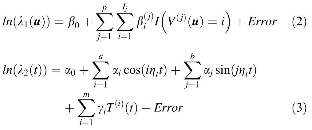
For simplicity,this article assumes a separable kernel with form:

where,last signi fi cant lagis determined by the autocorrelation function of the stochastic counting process Nt,which represents the number of observed forest fi res in an interval[0,t].
InhomogeneousK-andL-functions
Møller and Waagepetersen(2004)introduced the following inhomogeneous K-and L-functions to investigate existence of random,regular,or cluster patterns for speci fi c objects in a plane or space,under shot-noise Cox process


Stoyan and Stoyan(2000)and Diggle et al.(2005) developed a 95%-inter-quantile envelope for the-r function based upon an MCMC simulation study. Using such a 95%-inter-quantile envelope one may test the null hypothesis,H0:the model fi ts the data,at the 0.05 con fi dence level.Whenever the observed-r function falls into the 95%-inter-quantile envelope obtained by simulating points under the fi tted processone fails to reject the null hypothesis and concludes that the model fi t is adequate.
Annual data for Mazandaran forest fi res
This investigation used data on starting locations of 531 forest fi res in Mazandaran forests reported from March 2006 to March 2010(1826 days).The starting locations of these fi res were used as spatio-temporal points.Calculations were based on the supposition that the stochastic counting processstands for the number of daily forest fi res reported in the region.Bessie and Johnson(1995),and Møller and Diaz-Avalos(2010)processed information on vegetation type,elevation,slope,exposure and temperature as covariate information that may impact on a forest fi re in a given forest.Unfortunately,for this study information on vegetation type was not available from the relevant database.Therefore,this article considers altitude,slope-exposure,and average daily temperature (available at:http://www.mazandaranmet.ir/),of the region,T(t),as covariate information that may affect a forest fi re in the region.Altitude of the region averages approximately 1340 m asl.(Fig.2a,b)and can be classifi ed into 5 classes(Table 1).
Based on frequencies of slope and exposure,the area was classi fi ed into the 20 slope-exposure categories given in Table 2 and illustrated in Fig.2c.The spatial pattern of started forest f i res from March 2006 to March 2010 in the area has been given by Fig.2d.
Figure 3 represents average daily temperature,T(t),of the region(Fig.3a),the square root of the number of daily reported f i res in the region,i.e.,(Fig.3b),and autocorrelation of stochastic counting processfor different lags(Fig.3c).
Using the above autocorrelation plot for different lags (Fig.3,left panel),one cannot observe any signi fi cant autocorrelation after lag 32.Therefore,in Model(3)can be taken equal to 32.
Results
Using the Spatstat package(Baddeley and Turner 2005, 2006)against starting location of such reported f i re along with the above mentioned covariate variablesand power of daily temperatureThe spatial intensity functionand temporal intensity functioncan be estimated as the following:
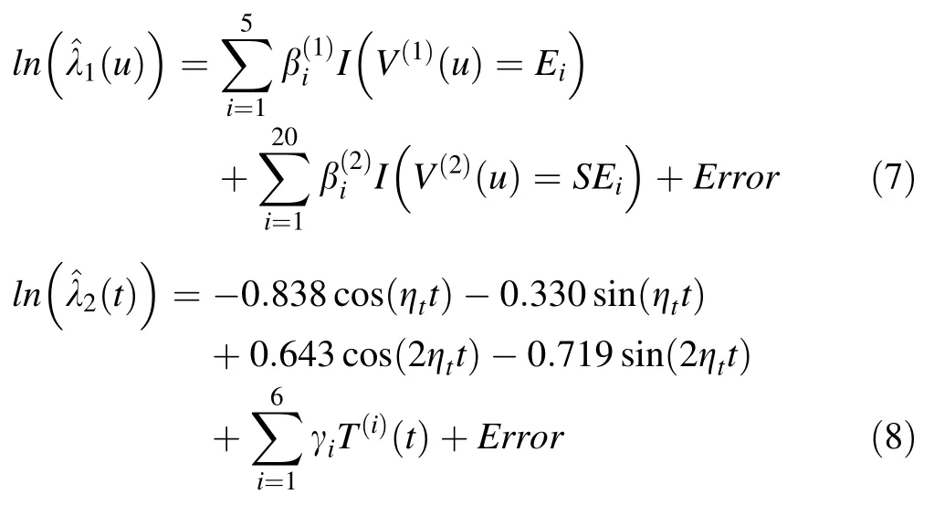
The maximum value for the exponent on daily temperature,m=6,was found by taking the largest value of m that minimizes the AIC(AIC=2581.697 for m=6, while the AIC equaled 2615.269,2586.638,and 2581.697 for m=3,m=4,and m=5,respectively).Goodness of fi t of the above spatio-temporal shot-noise Cox process model in spatial and spatio-temporal approaches was evaluated using a plot of the L(r)-r function and a 95%-inter-quantile envelope obtained from 39 simulations from the f i tted model.Figure 4 illustrates these plots.
Using regression parameters of estimated spatial average function λ1and temporal average function λ2(t)given by Eq.2,one can conclude that:(1)risk of forest f i re increased in areas with an altitude between 1350 m to 3000 m above sea level(corresponding to high positivevalues ofand(2)the risk of forest f i re in areas with a southern exposure and slope gradient of between 30° and 50°,northern exposure and slope gradient between 0° and 50°and eastern exposure and slope gradient between 00and 300(corresponding to high positive values ofwhich are signif icantly higher than other areas.
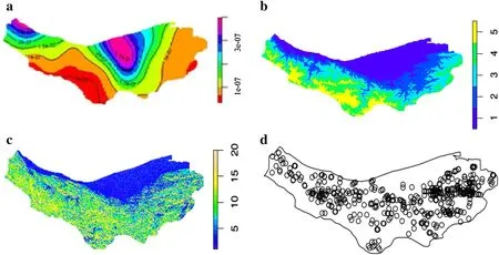
Fig.2 a Topographic map of urban and rural regions in Mazandaran Province;b elevation map,in meters,above sea level in the area;c the 20 slope-exposure categories;d spatial pattern of started forest f i re from March 2006 to 2010
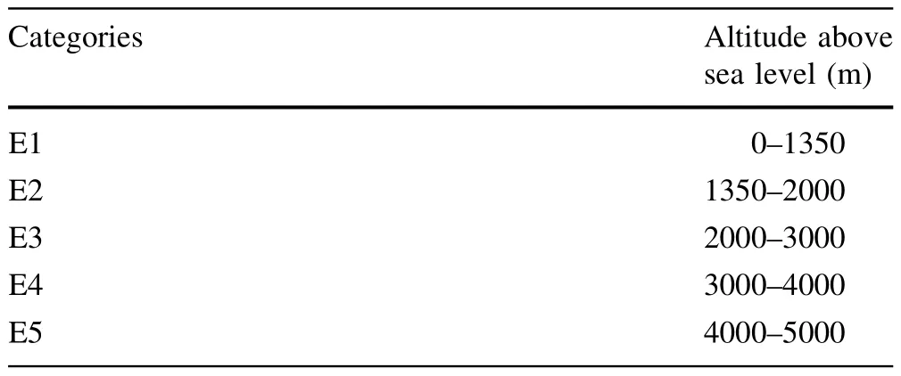
Table 1 Altitude categories classif i cation

Table 2 Slop-exposure categories classif i cation
Figure 4 shows that the L(r)-r function for the spatial shot-noise Cox model is far away from the edges of its 95%inter-quantile envelope(Fig.4a).While the L(r)-r function for the spatio-temporal shot-noise Cox model in most regions is close to the center line(red dash line)of its 95%inter-quantile envelope(Fig.4b).Therefore,one can conclude that the spatio-temporal shot-noise Cox model provides a more appropriate model compared to the spatial shot-noise Cox process.Moreover,Fig.4 also demonstrates that the pattern of the spatio-temporal shotnoise Cox model for forest f i res in the region is more aggregated than in an inhomogeneous Poisson process. Such aggregated spatial distribution dramatically increases in radiuses below 1 km away from the points for locations of f i res(beginning part of solid line in Fig.4b).This specif i c spatio-temporal and aggregate model verif i ed the periodic spatial distribution of f i re occurrence in the region and the fact that points close to f i re areas have a higher chance of f i re.
Figure 5 is a topographical map and realization graphs of the above estimated spatial average function λ1(u)and temporal average function λ2(u).
Comparing topographic maps of urban and rural regions in Mazandaran Province(Fig.1)with the estimated spatial average function λ1(u)(Fig.5a),it can be concluded that the risk of forest f i re in the eastern half and southwest of the area(rural and tourist regions)are considerably higher than the risk in other areas.The rate of occurrence of forest fi res in the period of study can be determined by the estimated temporal average function λ2(t)(Fig.5b).Realization of the estimated temporal average function λ2(t)is given by Fig.5c.

Fig.3 a Average of daily temperatureb squared root of number of daily reported fi re,i.e.,and c autocorrelation stochastic counting process Ntfor different lags

Table 3 Estimated parameters
Conclusion and discussion
This article employed a spatio-temporal shot-noise Cox process to:(i)determine factors that may impact forest f i res and(ii)to identify areas at higher risk of f i re in the forests of Mazandaran Province.
Using the f i tted model,one may conclude that:(1)daily temperature(with polynomial order 6),altitude and slopeexposure impacted occurrence of forest f i res in the region; (2)forest f i re occurrence had an aggregated spatial distribution,which means that points close to areas of f i re had more chance of f i re occurrence compared to other areas. Moreover,f i re chance dramatically increased in radiuses below 1 km away from areas of f i re;(3)the risk of forest fi re in the east and southwest of the area(rural and tourist regions)was considerably higher than the risk in other areas.These two observations were also reported in other research by HassanNayebi(2003)and,in a different context by Majidi et al.(2011);(4)f i re occurrence was considerably higher in southwest Mazandaran Province(where elevation was lower than average in the province,at 1340 m above sea level),similar f i ndings were reported in Ardakani et al.(2011);(5)the rate of forest f i re occurrence stayed above average during drought periods(September2008 and September 2009,Tirandaz and Eslami 2012);(6) the periodic spatial distribution of f i re occurrence in the region has also been reported by the U.N.FAO(2002, 2010);(7)risk of forest f i re is signif i cantly decreased in areas with an altitude higher than 3000 m above sea level.

Fig.4 Observed L(r)-r(solid line indicated by‘obs’)along with their 95%inter-quantile envelopes(grey region indicated by‘lo’and‘hi’)obtained from 39 simulated observations from the fi tted shotnoise-Cox model.Part a shows such L(r)-r from spatial model, while part b represents such estimations from spatio-temporal model

Fig.5 a Topographic map of estimated spatial intensity function λ1(u);b realization of estimated spatial intensity function λ1(u);and c realization of estimated temporal intensity function λ2(u)
The Model(7)provides useful spatial and temporal information that is not obvious or cannot be inferred from visual examination of raw data.Such quantitative knowledge could lead to the development of f i re-response and fi re-suppression strategies appropriate to specif i c regions within the province.The f i tted model can be improved by using other general information on f i res such as evaluations for area burned,date and time of ignition,weather conditions,causes and motivation,f i re f i ghting measures and vegetation type as well as detailed information on the forest land affected(e.g.,ownership,forest biomass of the area and estimated losses).Unfortunately,such covariate information was not available in the Iranian forest f i re database.More information would improve statistical forest f i re models and consequently facilitate better f i re management.Certainly,effective management practice requires an understanding of the role of biological and physical factors in patterns of f i re occurrence in space and over time.Moreover,high quality information about space–time dynamics of f i res can be developed by statistical models,which can be applied for long-term resource management of forest ecosystems and human property (McKenzie et al.2000).
AcknowledgmentsThe authors would like to thank Dr.Akhavan for his suggestions.Constructive reviewers’comments are much appreciated.
Amatulli G,Pere´z-Cabello F,de la Riva J(2007)Mapping lightning/ human-caused wildf i res occurrence under ignition point location uncertainty.Ecol Model 200:321–333
Ardakani AS,Zoej MJV,Mohammadzadeh A,Mansourian A(2011) Spatial and temporal analysis of f i res detected by MODIS data in Northern Iran from 2001 to 2008.Proc IEEE Geosci Remote Sens Soc Conf 4:216–225
Azizi A,Yousof i A(2009)Foehan and forest f i re in Mazandaran and Gilan provinces:a Case study for the forest f i re from December 16–21,2005.Geogr Res 24:2–228
Baddeley A,Turner A(2005)An R package for analyzing spatial point patterns.J Stat Softw 12:1–42
Baddeley A,Turner R(2006)Modelling spatial point patterns in R. Case studies in spatial point pattern modelling.Lect Notes Stat 185:23–74
BanjShaf i eia A,Akbariniab M,Jalalib G,Hosseini M(2010)Forest fi re effects in beech dominated mountain forest of Iran.For Ecol Manag 259:2191–2219
Benavent-Corai J,Rojo C,Sua´rez-Torres J,Velasco-Garcı´a L(2007) Scaling properties in forest f i re sequences:the human role in the order of nature.Ecol Model 205:336–342
Bessie WC,Johnson EA(1995)The relative importance of fuels and weather on f i re behavior in subalpine forest.Ecology 76:747–762
Brillinger DR,Preisler HK,Benoit JW(2006)Probabilistic risk assessment for wildf i res.Environmetrics 17:623–633
Chas-Amil ML,Touza J,Prestemon P(2010)Spatial distribution of human-caused forest f i res in Galicia(NW Spain).In:Proceeding of the second international conference on modelling,monitoring and management of forest f i res,pp 247–259
Couce E,Knorr W(2010)Statistical parameter estimation for a cellular automata wildf i re model based on satellite observations. In:Proceeding of the second international conference on modelling,monitoring and management of forest f i res,pp 37–47
Dayananda PWA(1977)Stochastic models for forest f i res.Ecol Model 3:309–313
Diggle PJ(1983)Statistical analysis of spatial point patterns. Academic Press,London
Diggle PJ,Rowlingson B,Su T(2005)Point process methodology for on-line spatiotemporal disease surveillance.Environmetrics 16:423–434
Food and Agriculture Organization(FAO)(2002)General status of the food and agriculture statistics in Iran.Available at:www. faorap-apcas.org/docs/05Iran/No.2IRA.pdf
Food and Agriculture Organization(FAO)(2010)Global forest resources assessment 2010.Available at:www.fao.org/docrep/ 013/i1757e/i1757e.pdf
Gralewicz NJ,Nelson TA,Wulder MA(2011)Spatial and temporal patterns of wildf i re ignitions in Canada from 1980 to 2006.Int J Wildland Fire 21:230–242
Guyette RP,Muzika RM,Dey DC(2002)Dynamics of an anthropogenic f i re regime.Ecosystems 5:472–486
HassanNayebi Esmail(2003)Identifying and combating with different f i res in forest.Extensional Programmes Institute,Tehran
Jiang Y,Zhuang Q,Mandallaz D(2012)Modeling large f i re frequency and burned area in canadian terrestrial ecosystems with poisson models.Environ Model Assess 3:1–12
Khosroshahi M,Ghavami S(2005)Hoshdar book.Publications of Forest and Rangelands,Tehran
Larjavaara M,Kuuluvainen T,Rita H(2005)Spatial distribution of lightning-ignited forest f i res in Finland.For Ecol Manag 208:177–188
Mahdavi A,Fallah Shamsi SR,Nazari R(2012)Forests and rangelands’wildf i re risk zoning using GIS and AHP techniques. Casp J Environ Sci 10:43–52
Majidi E,Sobhani K,Rezaei MR(2011)Deforestation of forests in Iran.J Appl Environ Biol Sci 1:184–186
Martı´nez J,Chuvieco E(2003)Tipologı´as de incidencia y causalidad de incendios forestales basadas en an’alisis multivariante. Ecologı´a 17:47–63
McKenzie D,Peterson DL,Agee JK(2000)Fire frequency in the interior Columbia River basin:building regional models from fi re history data.Ecol Appl 10:1497–1516
Mermoz M,Kitzberger T,Veblen TT(2005)Landscape inf l uences on occurrence and spread of wildf i res in Patagonian forests and shrub lands.Ecology 86:2705–2715
Mohammadi F,Shabanian N,Pourhashemi M,Fatehi P(2010)Risk zone mapping of forest f i re using GIS and AHP in a part of Paveh forests.Iran J For Poplar Res 18:586–595
Møller J,Diaz-Avalos C(2010)Structured spatio-temporal shot-noise Cox point process models,with a view to modelling forest f i res. Scand J Stat 37:2–25
Møller J,Waagepetersen RP(2004)Statistical inference and simulation for spatial point processes.Chapman and Hall/CRC,Boca Raton
Møller J,Waagepetersen RP(2007)Modern statistics for spatial point processes.Scand J Stat 34(4):643–684
Peng RD,Schoenberg FP,Woods J(2005)A space-time conditional intensity model for evaluating a wildf i re hazard index.J Am Stat Assoc 100:26–35
Pew KL,Larsen CPS(2001)GIS analysis of spatial and temporal pattern of human caused wildf i re in the temperate rain forest of Vancouver island Canada.For Ecol Manag 140(1):1–8
Prestemon JP,Butry DT(2005)Time to burn:modeling wildland arson as an autoregressive crime function.Am J Agric Econ 87:756–770
Ripley BD(1976)The second-order analysis of stationary point processes.J Appl Prob 13:255–266
Ryan KC(2002)Dynamic interactions between forest structure and fi re behavior in boreal ecosystems.Silva Fennica 36:13–39
Stoyan D,Stoyan H(2000)Improving ratio estimators of second order point process characteristics.Scand J Stat 27:641–656
Tirandaz M,Eslami A(2012)Zoning droughts and wetness trends in north of Iran:a case study of Guilan province.Afr J Agric Res 7:2320–2327
Turner MG,Romme WH(1994)Landscape dynamics in crown f i re ecosystems.Landsc Ecol 9:59–77
Wang Y,Anderson KR(2010)An evaluation of spatial and temporal patterns of lightning-and human-caused forest f i res in Alberta, Canada,1980–2007.Int J Wildland Fire 19:1059–1072
Yang J,He HS(2007)Spatial patterns of modern period human caused f i res in Missouri Ozrak highlands.For Sci 53:1–15
15 February 2014/Accepted:6 May 2014/Published online:17 July 2015
The online version is available at http://www.springerlink.com
Corresponding editor:Yu Lei
✉Amir T.Payandeh Najafabadi
amirtpayandeh@sbu.ac.ir
1Faculty Member of Department of Mathematical Sciences, Shahid Beheshti University,G.C.Evin,Tehran 1983963113, Iran
2Department of Basic Sciences,Payame Noor University Centre,Tehran,Iran
3Faculty Member of Department of Agricultural Sciences, Science and Research Branch,Islamic Azad University, Tehran,Iran
 Journal of Forestry Research2015年4期
- Journal of Forestry Research的其它文章
- Culm characteristics and volume-weight relationship of a forest bamboo(Melocanna baccifera(Roxb.)Kurz)from northeast India
- Effects of characteristic inhomogeneity of bamboo culm nodes on mechanical properties of bamboo f i ber reinforced composite
- Simulating the heartwood formation process of Erythrophleum fordii in South China
- Wood liquefaction with phenol by microwave heating and FTIR evaluation
- The inf l uences of biotic and abiotic factors on the occurrence and severity of poplar canker disease in Qingfeng County,China and the management implications
- Purif i cation and structural analysis of the toxin AP-I from the pathogen of Bambusa pervariabilis×Dendrocalamopsis grandis blight
