
The First Observed Cloud Echoes and Microphysical Parameter Retrievals by China’s 94-GHz Cloud Radar
2014-04-12 08:24:10WUJuxiuWEIMingHANGXinZHOUJieZHANGPeichangandLINan
WU JuxiuWEI MingHANG XinZHOU JieZHANG Peichangand LI Nan
1Collaborative Innovation Center on Forecast and Evaluation of Meteorological Disasters,Nanjing University of Information Science&Technology,Nanjing210044
2Key Laboratory for Aerosol-Cloud-Precipitation of China Meteorological Administration,Nanjing University of Information Science&Technology,Nanjing210044
3School of Electronic&Information Engineering,Nanjing University of Information Science&Technology, Nanjing210044
The First Observed Cloud Echoes and Microphysical Parameter Retrievals by China’s 94-GHz Cloud Radar
WU Juxiu1,2,WEI Ming1,2∗,HANG Xin2,ZHOU Jie3ZHANG Peichang1,2,and LI Nan2
1Collaborative Innovation Center on Forecast and Evaluation of Meteorological Disasters,Nanjing University of Information Science&Technology,Nanjing210044
2Key Laboratory for Aerosol-Cloud-Precipitation of China Meteorological Administration,Nanjing University of Information Science&Technology,Nanjing210044
3School of Electronic&Information Engineering,Nanjing University of Information Science&Technology, Nanjing210044
By using the cloud echoes fi rst successfully observed by China’s indigenous 94-GHz SKY cloud radar,the macrostructure and microphysical properties of drizzling stratocumulus clouds in Anhui Province on 8 June 2013 are analyzed,and the detection capability of this cloud radar is discussed.The results are as follows. (1)The cloud radar is able to observe the time-varying macroscopic and microphysical parameters of clouds, and it can reveal the microscopic structure and small-scale changes of clouds.(2)The velocity spectral width of cloud droplets is small,but the spectral width of the cloud containing both cloud droplets and drizzle is large.When the spectral width is more than 0.4 m s−1,the radar re fl ectivity factor is larger(over –10 dBZ). (3)The radar’s sensitivity is comparatively higher because the minimum radar re fl ectivity factor is about–35 dBZ in this experiment,which exceeds the threshold for detecting the linear depolarized ratio(LDR)of stratocumulus(commonly –11 to –14 dBZ;decreases with increasing turbulence).(4)After distinguishing of cloud droplets from drizzle,cloud liquid water content and particle e ff ective radius are retrieved.The liquid water content of drizzle is lower than that of cloud droplets at the same radar re fl ectivity factor.
94-GHz cloud radar,echo analysis,stratocumulus,microphysical parameters
1.Introduction
Clouds are known to play a crucial role in theearth’sradiation balance,weatherforecasts, weather modi fi cation,and fl ight safety(Liou,1986). The main tools for detecting clouds are airborne instruments,microwaveradiometers,ceilometers, centimetre-wave radars,satellite observations,radiosondes,and millimetre-wave radars. Among these,the millimetre-wave cloud radar has proven to be invaluable for observing non-precipitating and weakly precipitating clouds. The radar signal can penetratethick cloudsto observetheirinternal structures(Krop fl i et al.,1995;Kro fl i and Kelly,1996;Illingworth et al.,2007).A very important issue regarding the use of radars at millimetre wavelengths is signal attenuation due to clear air,clouds,and precipitation.The attenuation in terms of rain and drizzle intensity is presented and discussed in Lhermitte(2002).Usually,the wavelengths of millimetrewave cloud radars are 3 mm(at frequencies of approximately 94 GHz)and 8 mm(at frequencies of approximately 35 GHz).The 94-GHz radars can detect smaller cloud droplets and the early formation of clouds.Additionally,94-GHz radars are fairly immune to ground clutter that is detected through antenna side lobes in a vertically pointing beam mode because of their short wavelength(Lhermitte,2002).
The Ka-band radars in the United States have been developed since the 1950s.In the early 1970s, the American Air Force developed TPQ-11 radar (with 8.5-mm wavelength),which were combined with Doppler and dual polarization functions and used in cloud physics research in the late 1980s(Sauvageot and Omar,1987;Krop fl i et al.,1995). The 35-GHz synthetic aperture radar and the 35-GHz/94-GHz millimetre-wave cloud radar were developed in America in 1992 and 1994,respectively(Zhong et al.,2009). These instruments can be used to detect and identify ice clouds,supercooled water,and the particle size distribution of clouds(Zhong et al.,2009).The fi rst unmanned 35-GHz cloud radar,which was developed in 1996,was used for a cloud radiation test project.It observed the echo characteristics of non-precipitating and weakly precipitating clouds for a long term(Clothiaux et al.,1999).The American W-band radars(3-mm wavelength)were introduced in the early 1980s and mainly used to study cloud and precipitation physics in the late 1980s(Lhermitte,2002).Britain developed the 94-GHz Galileo and 35-GHz Copernicus Doppler radars,which were used to invert cloud particle sizes and density in the 1990s(Hogan et al.,2000). In 1995,a polarimetric cloud radar with a wavelength of 3 mm began operating at the GKSS Research Centre,Geesthacht,Germany.It has been used for case studies of various stratiform,non-precipitating cloud systems(Danne et al.,1999).In 2000 and 2003,Japan developed the 95-GHz airborne cloud pro fi ling radar and 35-GHz Doppler radar,respectively,which were used to retrieve the turbulence in clouds,and the vertical velocity distribution of the air fl ow,among other variables(Hamazu et al.,2003).In 2006,the 94-GHz CPR(Cloud Pro fi ling Radar)carried by the CloudSat satellite provided vertical pro fi les of liquid water,ice water,and radiation characteristics of clouds(Zhong et al.,2010).In the 21st century,millimetre-wave radars are rapidly developing across the globe.
Because China participated relatively late in the development of millimetre-wave radars,the fi rst 8.6-mm millimetre-wave radar was used for meteorological observations with high sensitivity.The Doppler and polarized functions were developed by the Chinese Academy of Meteorological Sciences and the 23rd Research Institute of the 2nd Academy of Chinese Aerospace in 2007.Presently,domestic 94-GHz millimetre-wave cloud radars are being developed.A 94-GHz SKY cloud radar with a Doppler function is being developed by Sun-create Electronics Company in Anhui.In China,ground-based radar research should and will ultimately transfer to airplane-based radar research.
Retrievals of cloud microphysical parameters are important to numerical model prediction,weather forecasting,weather modi fi cation operation,and aviation safety.Millimetre-wave cloud radars can be used to retrieve cloud parameters,such as cloud particle e ff ective radius and cloud liquid water content.The primary methods that are used to retrieve microphysical parameters of clouds are empirical relations(Atlas,1954;Sassen and Liao,1996;Fox and Illingworth, 1997;Sassen et al.,1999),multiple sensors(Frisch et al.,1995,1998;O’Connor et al.,2004),dual wavelengths(Hogan et al.,2000),and Doppler spectral data(Gossard et al.,1990;Babb and Verlinde,2000; Shupe et al.,2004).Using the particle size distribution(PSD)of warm cumulus under plane detecting, Fox and Illingworth(1997)obtained the empirical relationships between radar re fl ectivity factor,liquid water content,and particle e ff ective radius.Combining millimetre-wave radar and a microwave radiometer, Frisch et al.(1998)studied the microphysical parameters of stratiform clouds.Shupe et al.(2004)dis-cussed the microphysical parameters of mixed-phase clouds using the Doppler spectrum of a 35-GHz radar.
By using the cloud echoes fi rst successfully observed by a 94-GHz SKY cloud radar,the macrostructure and the microphysical parameters of low drizzling clouds in Anhui Province on 8 June 2013 are analyzed in this paper.Additionally,the detection ability of the SKY cloud radar is discussed.
2.Radar operational parameters and rationale
2.1 SKY radar operational parameters
The SKY millimetre-wave cloud radar is the fi rst 94-GHz radar developed by China;thus,it is fairly challenging to obtain echoes based on the current hardware technology.The main parameters of the SKY cloud radar are listed in Table 1.
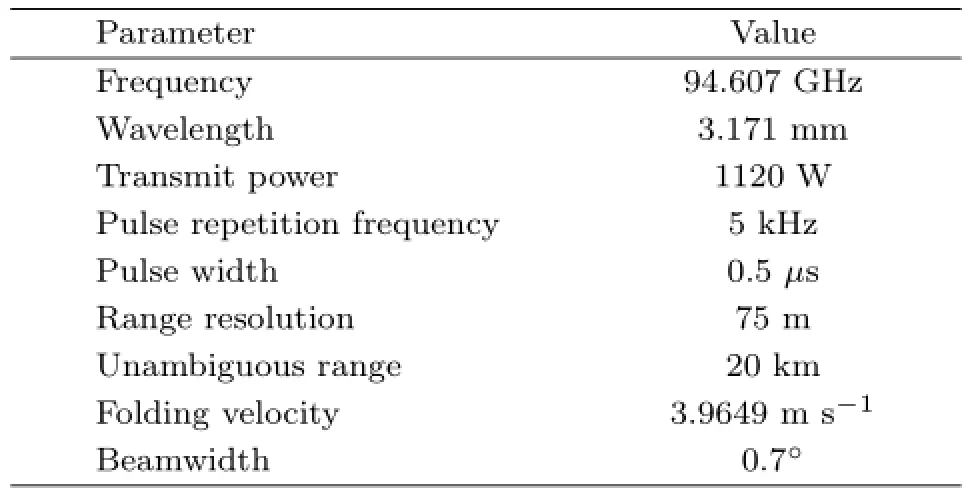
Table 1.SKY radar operational parameters
2.2 Rationale
The cloud liquid water content and particle e ff ective radius are important microphysical parameters. For an assumed log normal droplet size distribution, the relationships between re fl ectivity factor,droplet e ff ective radius(re;μm),and liquid water content (LWC;g m−3)are expressed as follows(Frisch et al., 1995;Danne et al.,1999;Shupe et al.,2004):

whereZis re fl ectivity factor(mm6m−3),Nis droplet number concentration(cm−3),σis the logarithmic spread of the droplet size distribution,andρis density of water re fl ectivity.Equations(1)and(2)indicate thatZ-LWC andZ-rerelations can be determined ifσandNare selected according to the cloud type.
TheZ-LWC relationship in weakly nonprecipitating clouds was suggested by Atlas(1954), Sauvageot and Omar(1987),and Fox and Illingworth (1997).Many measurements that were taken by aircraft show that drizzle often appears in clouds with a re fl ectivity factor approaching –15 dBZ(Sauvageot and Omar,1987).Baedi et al.(2000)obtained the LWC of stratocumulus with drizzle.The radar re fl ectivity factor of precipitating particles is larger,but the contribution to the cloud LWC is minimal.Therefore, the presence of precipitation in the clouds should infl uence the interpretation of cloud water content.As a result,suitable inversion formulas should be selected according to cloud particle types.
Two methods are used to distinguish cloud droplets from precipitating particles.First,particles with radii less than 25μm mainly grow by condensation,whereas particles with radii greater than 25μm mainly grow by coalescence(Cober et al.,1996). Thus,a 25-μm radius can distinguish di ff erent particle types in clouds(Frisch et al.,1995;Kollias et al., 2011a).Kollias et al.(2011a)suggested that the value ofZin the range of –20 to –15 dBZ and the spectral width of 0.25 m s−1indicate the generation of drizzle with radii larger than 25μm.Second,particles with radii larger than 100–125μm are considered precipitation particles because they often reach the ground, whereas particles with radii less than 100μm are considered cloud droplets because their falling speed is small,according to the relationship between size and falling speed of the particles(Sauvageot and Omar, 1987).Zong(2013)suggested that the threshold(the radius of the particles greater than 100μm)is –15 to –12 dBZ.In this study,we assume that particles smaller than 50μm are cloud droplets,whereas those larger than 1 mm are raindrops.Particles with radii from 25 to 500μm are treated as drizzle.Thus,the distinction between cloud droplets and drizzle drops is a 25-μm radius.In calm conditions,the falling speed of cloud droplets is only a few centimetres per second, which is lower than the atmospheric vertical speed by 1–2 orders of magnitude.Hence,the cloud dropletmovement can be regarded as air movement(Kollias et al.,2002;Shupe et al.,2008).
3.Analysis of the fi rst cloud echoes observed by SKY radar
On 8 June 2013,the SKY cloud radar successfully detected cloud echoes in Hefei,Anhui Province (31.821°N,117.19°E)for the fi rst time.The speci fi c time was 1357–1427 BT(Beijing Time)and 1523–1536 BT.The radar was zenith pointing and installed on an automobile.
3.1 Analysis of weather conditions
To better analyze the cloud radar echoes,we fi rst examine the background real weather conditions using satellite cloud images,weather charts,sounding data, and ground observations on 8 June 2013.
3.1.1Weather chart analysis
Figure 1 shows the 500-hPa geopotential height and temperature fi elds,and 850-hPa wind fi eld at 0800 BT 8 June 2013.A developed cyclone,namely,the Jiang-Huai cyclone,is seen near Jiangsu Province and the East China Sea at this time.The cyclone is steered by the westerlies. Meanwhile,there is a low-level trough over Jiangsu and Zhejiang provinces,which is oriented southwest to northeast.An encounter between the southwest warm moist air fl ows ahead of the trough and the northwest air behind the trough leads to atmospheric instability.Combined with favorable moisture conditions,it is easy to form clouds and precipitation.At 2000 BT 8 June( fi gure omitted),the low trough weakens and slightly shifts to the east;later,it gradually exits the territory of Anhui Province and shifts to the east.
3.1.2Analysis of FY2E satellite cloud image
Figure 2 displays the infrared bright temperature from the FY2E satellite at 1400 BT 8 June 2013.The Jiang-Huai cyclone center seems not associated with severe weather,such as heavy rain.It is clearly seen that low clouds appear over Hefei City.
3.1.3Anqing sounding data analysis

Fig.1.Weather chart of geopotential height(blue)and temperature(red)at 500 hPa,and wind(barb)at 850 hPa at 0800 BT 8 June 2013.

Fig.2.Infrared bright temperature from FY2E satellite at 1400 BT 8 June 2013.
The Anqing sounding station is the nearest sounding station(30.53°N,117.05°E)to the radar location; thus,the sounding data are used as a reference.Figure 3 presents theT-logPrelation over Anqing at 1400 BT 8 June 2013.It is indicated that the water vapor at low altitudes over the station is sufficient.The di ff erence between the dew point and actual temperature is less than 2℃,and the relative humidity is higher than 85%between 925 and 770 hPa.The di ff erences are 1℃ and 94%at 925 hPa(near saturation).A stratocumulus layer exists between 925 and 770 hPa,in which the cloud base is approximately 720 m and the cloud top is near 2.7 km.The depth of the liquid layer is approximately 1 km,and the height of the freezing level is approximately 5.2 km.
3.1.4Surface observation analysis
According to the surface observation data at 1400 BT 8 June 2013 from Hefei station(31.87°N, 117.23°E),which is nearest to the experiment site, the weather was cloudy,then characterized by intermittent light rain.Fracto-nimbus with a cloud base height of 300 m developed,which produced 0.2 mm ofrainfall within 6 h and a surface wind speed of 2 m s−1. The Anqing station,which is a bit farther from the experiment site,recorded cloudiness.Initially,the rain was light.Stratocumulus clouds were present with a cloud base of 300 m and a surface wind speed of 4 m s−1.
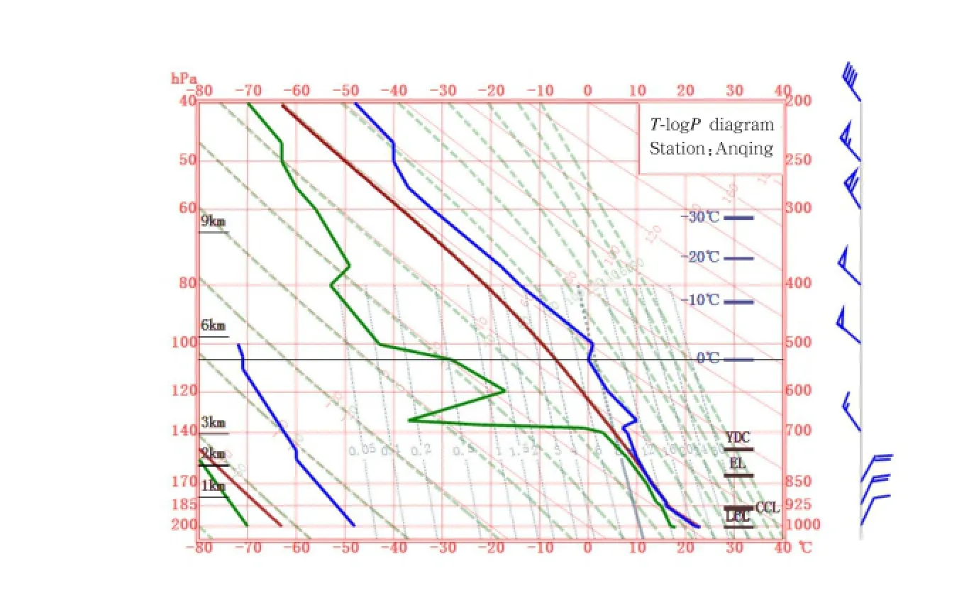
Fig.3.T-logPplot over Anqing sounding station at 1400 BT 8 June 2013.
3.2 Radar echo analysis
Figure 4 shows the radar re fl ectivity factor, Doppler velocity,Doppler velocity spectral width,and linear depolarized ratio(LDR)during 1347–1357 BT 8 June 2013.As the cloud radar is vertical pointing, the Doppler velocity is also the mean falling velocity of the droplets.LDR can reveal the non-spherical extent of particles.The height of the cloud top is approximately 2.0 km and the cloud is likely low stratocumulus as judged by previous and current radar echoes.The Doppler speed at the cloud top indicates a downdraft.Due to arti fi cial settings,the radar cannot observe the cloud base.According to surface observations,the height of the cloud base is approximately 300 m,so the thickness of the cloud is roughly 1.7 km. Figure 4 also shows that the radar re fl ectivity factor of the cloud is –27 to 0 dBZ,and the spectral width is higher than 0.25 m s−1(i.e.,drizzle exists in the cloud).The re fl ectivity factor threshold of the precipitating particles is above –20 dBZ,and the spectral width of the two types of particles is higher than 0.25 m s−1(Baedi et al.,2000).Furthermore,the radar refl ectivity factor,Doppler velocity,and spectral width increase as the height decreases,indicating growth of cloud droplet with height.Below 1 km,the corresponding spectral width exceeds 0.4 m s−1,which suggests that the drizzle in the cloud is enhanced.Two zones of changing velocity are shown at the bottom of Fig.4b at 1356 BT.These ambiguous velocities are due to the fact that the actual velocity exceeds 4 m s−1,which is attributed to large particles.The LDR is less than –20 dB in the case of spherical particles,which is consistent with the results obtained with China’s 35-GHz radar(Sun,2011).According to the Doppler velocity shown in Fig. 4b,no upward movement occurs in the cloud.Above 2 km,the cloud region in which the Doppler velocity reaches 0 or–3.5 m s−1appears as noise in the radar system.

Fig.4.(a)Radar re fl ectivity factor,(b)Doppler velocity,(c)Doppler velocity spectral width,and(d)LDR during 1347–1357 BT 8 June 2013.

Fig.5.Vertical pro fi les of(a)radar re fl ectivity factor,(b)Doppler velocity,(c)Doppler velocity spectral width,and (d)LDR at 1349 BT 8 June 2013.
Figure 5 shows the vertical pro fi les of the radar re fl ectivity factor,Doppler velocity,Doppler velocity spectral width,and LDR at 1349 BT 8 June 2013. The velocity(–3.5 m s−1)jumps to –1.1 m s−1over a range of approximately 100 m,which is unreasonable. It may be explained by the low radar signal to noise ratio(SNR).Near the cloud top of 2 km,the radar refl ectivity factor is less than –25 dBZ and the spectral width is nearly 0 m s−1,which reveals a low concentration of small particles at the cloud top.Furthermore,Zis –14 dBZ,which corresponds to a spectral width of approximately 0.25 m s−1over about 1.5 km;thus, drizzle appears.Near 1.25 km,at high radar re fl ectivity factors(–5 dBZ),the spectral width “jumps” to a higher value(about 0.4 m s−1)and LDR “jumps”to a lower value(approximately –25 dB).This suggests the increasing contribution of PSD broadeningto the observed Doppler spectral width values due to drizzle growth.At even higher radar re fl ectivity factors,the spectral width continues to slowly increase such that the drizzle droplets in the cloud region grow by coalescence and fall to the ground.Above 1.5–1.7 km,the radar re fl ectivity factor,Doppler velocity, and spectral width increase as the height decreases; this reveals that the cloud droplets grow mainly by condensation.A low re fl ectivity factor(<–20 dBZ) or low spectral width(<0.25 m s−1)indicates that the vertical Doppler velocity is a good representation of the air motion(Frisch et al.,1995).The spectral width distribution shows cloud droplets above 1.5 km, so the corresponding mean Doppler velocities can be treated as the vertical velocity of the air.Then,the vertical velocity of the air within the cloud changes with height.AtZ= –25 dBZ(about 1.8 km),we observe that the vertical velocity of the air is approximately –1.1 m s−1.The LDR is around –20 dB,and it does not exist above 1.5–1.6 km,which corresponds to a maximumZof –14 dBZ and spectral width of 0.25 m s−1.The values of LDR>–10 dB at 1.7 km are too large to be credible.
Figure 6 shows the radar re fl ectivity factor, Doppler velocity,Doppler velocity spectral width,and LDR during 1407–1417 BT 8 June 2013.According to the examination of all the echoes observed by the radar in the afternoon,some protrusions from the cloud top appear to be stratocumulus clouds.Drizzle fades away and evaporates completely before reaching the ground. The positive velocity within the cloud top at 1409 BT is caused by the updraft.After 1411 BT,Zchanges from –15 to –35 dBZ and a spectral width smaller than 0.25 m s−1appears,indicating that the drizzle has disappeared.Additionally,the vertical velocities of the air within the cloud change greatly with height.At the 0.5-km altitude,values ofZand spectral width of the cloud decrease to –35 dBZ and 0 m s−1,respectively, and no LDR exists,which explains the height of the cloud base.Figure 6 also indicates that clouds with spectral widths larger than 0.4 m s−1often exhibit a higher re fl ectivity factor(Z>–10 dBZ)due to the contribution of drizzle.
Figure 7 displays the vertical pro fi les of radar refl ectivity factor,Doppler velocity,and Doppler velocity spectral width at 1409 BT 8 June 2013.Below 2 km,the radar re fl ectivity factor fi rst increases and then decreases as height decreases;the spectral width has a corresponding change,but the Doppler velocity basically increases as height decreases.This indicates that cloud droplets and drizzle fi rst grow and then evaporate.At the highest radar re fl ectivity factor (–10 dBZ),the spectral width decreases rapidly(from 0.3 to 0.25 m s−1),but the Doppler velocity retains its highest value(–3 m s−1).This is the contribution of PSD narrowing to the observed Doppler spectral width values due to small cloud droplets evaporating fi rst.At the height of 0.6 km withZ= –27 dBZ, the Doppler velocity begins to decrease and reveals a cloud base height of approximately 0.6 km.Although the largestZis –10 dBZ and the largest spectral width is 0.35 m s−1,only one value of LDR appears,so LDR is not shown.
Figure 8 shows radar re fl ectivity factor,Doppler velocity,Doppler velocity spectral width,and LDR during 1524–1534 BT 8 June 2013.Combined with previous detections,Fig.8 indicates that the cloud has newly developed non-uniformity in the vertical and horizontal structures(i.e.,the cloud top is no longer fl at).The largest re fl ectivity factor in the cloud is –5 dBZ,at which point drizzle is produced again.The upper part of the cloud dissipates over time,and the drizzle evaporates while falling.Meanwhile,the lower part of the cloud develops over time.The radar refl ectivity factor,Doppler velocity,and spectral width increase as height decreases after 1531 BT.When spectral width reaches 0.8 m s−1and LDR is less than –20 dB,drizzle should fall.At the height of 500 m between 1531 and 1532 BT,the largest upward velocity is 1 m s−1.Because the Doppler velocity near the cloud region with upward motion changes continuously,the upward velocity is updraft,rather than fuzzy velocity, which indicates air turbulence.This should account for the rain on the following day.
Figure 9 displays the vertical pro fi les of radar re fl ectivity factor,Doppler velocity,Doppler velocity spectral width,and LDR at 15:31:03 BT 8 June 2013. The upper part of the cloud disappears gradually,andthe radar re fl ectivity factor of the lower part of the cloud generally increases as height decreases.Thus, the particles increase,but the corresponding Doppler velocity fi rst increases and then decreases.At 0.6 km, updrafts occur,which lead to the velocity decrease below 0.8 km.This is associated with a large spectralwidth and an LDR increase from –20 to –18 dB.The minimumZ= –16 dBZ corresponds to a measurable LDR by the radar and shows that the threshold can be reduced in the case of air turbulence.By analyzing test data,the threshold is found to be commonly–11 to –14 dBZ and to decrease with turbulence en-hancement(e.g.,the lowest threshold in the test is –20 dBZ).
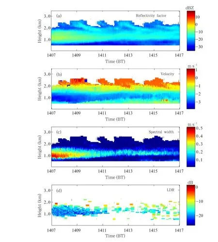
Fig.6.(a)Radar re fl ectivity factor,(b)Doppler velocity,(c)Doppler velocity spectral width,and(d)LDR during 1407–1417 BT 8 June 2013.

Fig.7.Vertical pro fi les of(a)radar re fl ectivity factor,(b)Doppler velocity,and(c)Doppler velocity spectral width at 1409 BT 8 June 2013.
Among all the radar echoes on the experiment day,the detectable minimum re fl ectivity factor is about –35 dBZ at 1 km.The echo data show that it has drizzled o ffand on,which agrees with the actual weather reports.The radar can clearly observe the rapidly changing microphysical parameters and the physical characteristics of the stratocumulus clouds.
4.Retrievals of cloud microphysical parameters
The detection capability of the SKY cloud radar is further analyzed by cloud microphysics retrievals during 1347–1357 and 1407–1417 BT.Because the clouds are warm,we retrieve the cloud liquid water content and particle e ff ective radius.It is known that radar re fl ectivity factor is proportional to the sixth power of the particle diameter.Therefore,echo intensity of the cloud is controlled by the drizzle in the cloud,but the contribution of the drizzle to the liquid water content is smaller than that of cloud droplets at the same echo intensity.For the clouds containing drizzle,the cloud water content is obtained by using the equation in Baedi et al.(2000).Furthermore,the e ff ective radii of the cloud droplets and drizzle are estimated based on Eq.(1).
According to Frisch et al.(1995),Baedi et al. (2000),and Kollias et al.(2011a,b),when retrieving particle e ff ective radius,we use the Doppler velocity spectral width of 0.25 m s−1as the threshold to distinguish cloud droplets and drizzle in the cloud.During 1347–1357 BT,a logarithmic spectral width of 0.32, a concentration of 35 cm−3for cloud droplets,and a concentration of 0.05 cm−3for drizzle,are used.The particle e ff ective radius and cloud liquid water content retrieved are depicted in Figs.10 and 11,respectively. Figure 10 shows that the cloud droplet e ff ective radius in the upper boundary of the cloud is approximately 10μm.The e ff ective radii of a number of drizzle droplets at the 500-m altitude are 70–100μm. According to surface observations,it is drizzling.The particles in the cloud should grow while falling to the ground.Therefore,an e ff ective radius larger than 70μm for a large number of drizzle droplets in the cloud is reasonable in the inversion.In fact,cloud droplets are also found in the area,but are not re fl ected because the re fl ectivity factor of the drizzle obscures the re fl ectivity factor of the cloud droplets.
Figure 11 indicates that the liquid water content of the cloud is mainly 0.2–0.6 g m−3.The lowest water content is located at the cloud boundary,while the highest water content reaches 0.99 g m−3,according to the calculations.When the drizzle is stronger,the cloud water content is larger.Based on the statistics, the cloud liquid water content of stratus or stratocumulus is 0.4–0.8 g m−3,so the results are reasonable.
By using the same method,the particle e ff ective radius and cloud liquid water content during 1407–1417 BT are retrieved and shown in Figs.12 and 13, respectively.The logarithmic spectral width of 0.31, the concentrations of 35 cm−3for cloud droplets,and 0.01 cm−3for drizzle,are used in Eq.(1).Figure 12 indicates that the e ff ective radius of cloud droplets is approximately 10μm,the largest drizzle is 79μm,andthe drizzle gradually disappears as time passes.
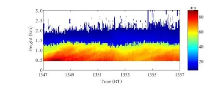
Fig.10.E ff ective radius of the particles in the cloud during 1347–1357 BT 8 June 2013.

Fig.11.Liquid water content of the cloud during 1347–1357 BT 8 June 2013.
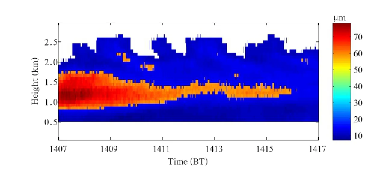
Fig.12.E ff ective radius of the particles in the cloud during 1407–1417 BT 8 June 2013.
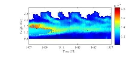
Fig.13.Liquid water content of the cloud during 1407–1417 BT 8 June 2013.
Figure 13 indicates that the cloud water content is 0.1–0.8 g m−3.The low cloud water content is located at the boundary of the cloud and higher cloud water content is located near the cloud center.Additionally, the water content in the cloud area containing large drizzle droplets is approximately 0.6 g m−3.
If the cloud during 1407–1417 BT is mistaken for weak cloud(i.e.,drizzle is not distinguished from cloud droplets),the e ff ective radius and liquid water content can be calculated by using the empirical relations proposed by Fox and Illingworth(1997).Figure 14a shows that the cloud particle e ff ective radii are 7–20μm,larger particles mainly exist in the middle of the cloud,and the particle e ff ective radius decreases over time.However,the result is not reasonable becausedrizzle is missed in the inversion.Figure 14b shows that the liquid water content is 0.1–3.5 g m−3and the cloud liquid water at the boundary is low.The liquid water content for the cloud without drizzle after 1411 BT is reasonable,but that of the cloud containing drizzle is clearly overestimated.Therefore,the results of the retrievals are greatly impacted by the judgment of whether it is drizzling or not in a cloud.
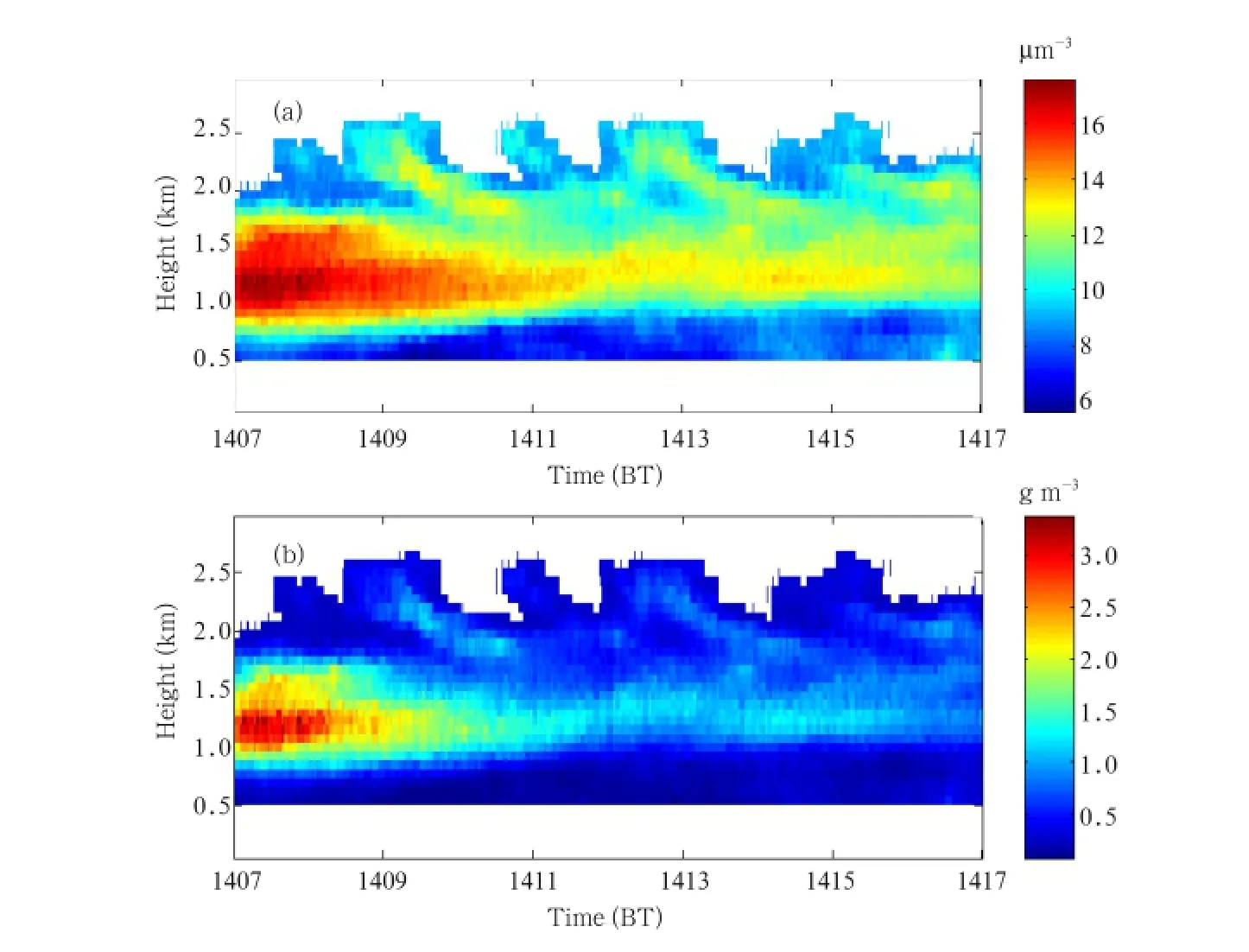
Fig.14.(a)E ff ective radius and(b)liquid water content of the cloud,assuming no precipitation in the cloud during 1407–1417 BT 8 June 2013.
5.Conclusions
By using the cloud echoes fi rst successfully detected by China’s indigenous 94-GHz SKY cloud radar,the detection capability of the cloud radar is evaluated through analyzing the macrostructure and microphysical parameters of stratocumulus clouds. The results prove to be of good reference for further research and improvement of the W-band cloud radar.
(1)The cloud radar can observe the time-varying macro-and microscopic cloud parameters and reveal the microscopic structures and small-scale changes of the clouds such as turbulence.The evolving echoes re fl ect changes of droplet parameters and structures of the cloud with drizzle.In our experiment,the detectable minimum re fl ectivity factor is about –35 dBZ (i.e.,the radar’s sensitivity is high).Observations of the echoes are consistent with the actual weather conditions.
(2)The vertical air velocity of low clouds changes with time and height.The velocity spectral width of a certain type of particle is small,but the spectral width containing cloud droplets and drizzle is large. When the spectral width is more than 0.4 m s−1,the radar re fl ectivity factor is usually larger(more than–10 dBZ).The threshold is commonly –11 to –14 dBZ, which corresponds to a measurable LDR by the radar and decreases with turbulence enhancement.
(3)After distinguishing the cloud droplets from drizzle,we obtained the liquid water content and the e ff ective radii.Drizzle has a high radar re fl ectivity factor,but it has lower liquid water content than cloud droplets at the same re fl ectivity factor.In the experiment,the e ff ective radius of the droplets in the cloud is approximately 10μm,the drizzle e ff ective radius is greater than 25μm,and the largest e ff ective radius is over 90μm.
Because we assume that the values of the particle concentration and logarithmic spectral width in theinversion are constant,the results using theZ–rerelationship have uncertainties. The uncertainties in all-liquid clouds are approximately 50%for LWC(Fox and Illingworth,1997)and 13%forre(Frisch et al., 2002).The inversion results are not validated by an e ff ective mean.In the present study,no attenuation correction is applied to the W-band radar re fl ectivity measurement.The attenuation is proportional to the liquid water content in the region of Rayleigh scattering.Because the cloud radar is still being developed and debugged,no other echoes have been obtained and strong noise sometimes occurs in the detecting system.Furthermore,we did not remove the noise in the inversion.In later work,the software and hardware systems of the radar will be improved,more stable and reliable data can be obtained,and airborne detection should ultimately be implemented.When using the Doppler radar output spectrum,we can invert and retrieve the droplet liquid water content, drizzle liquid water content,drizzle e ff ective radius, and vertical movement of the air in a precipitating cloud.In the future,the simultaneous use of several remote sensing instruments with di ff erent wavelengths is desired to reduce the errors due to inaccuracies in the measured quantities.
Acknowledgments.We thank Professor Chen Daren for his signi fi cant help.
REFERENCES
Atlas,D.,1954:The estimation of cloud parameters by radar.J.Meteor.,11,309–317.
Babb,D.M.,and J.Verlinde,2000:The retrieval of turbulent broadening in radar Doppler using linear inversion with double-sided constraint.J.Atmos. Oceanic Technol.,17,1577–1583.
Baedi,R.J.P.,J.J.M.de Wit,H.W.J.Russchenberg,et al.,2000:Estimating e ff ective radius and liquid water content from radar and lidar based on the CLARE’98 dataset.Phys.Chem.Earth,25, 1057–1062.
Clothiaux,E.E.,K.P.Moran,B.E.Martner,et al., 1999:The atmospheric radiation measurement program cloud radars:Operational modes.J.Atmos. Oceanic Technol.,16,819–827.
Cober,S.G.,J.W.Strapp,and G.A.Isaac,1996:An example of supercooled drizzle drops formed through a collision-coalescence process.J.Appl.Meteor., 35,2250–2260.
Danne,O.,M.Quante,D.Milferst¨adt,et al.,1999:Relationships between Doppler spectral moments within large-scale cirro-and altostratus cloud fi elds observed by a ground-based 95 GHz cloud radar.J. Appl.Meteor.,38,175–189.
Fox,N.I.,and A.J.Illingworth,1997:The retrieval of stratocumulus cloud properties by ground based cloud radar.J.Appl.Meteor.,36,485–492.
Frisch,A.S.,C.W.Fairall,J.B.Snider,1995:Measurement of stratus cloud and drizzle parameters in ASTEX with a Ka-band Doppler radar and a microwave radiometer.J.Atmos.Sci.,52,2788–2799.
—–, —–,G.Feingold,et al.,1998:On cloud radar and microwave radiometer measurements of stratus cloud liquid water pro fi les.J.Geophys.Res.,103(D18), 23195–23197.
—–,M.Shupe,I.Djalalova,et al.,2002:The retrieval of stratus cloud droplet e ff ective radius with cloud radars.J.Atmos.Oceanic Technol.,19,835–842.
Gossard,E.E.,R.O.Strauch,and R.R.Rogers,1990: Evolution of drop size distributions in liquid precipitation observed by ground-based Doppler radar.J. Atmos.Oceanic Technol.,7(6),815–828.
Hamazu,K.,H.Hashiguchi,T.Wakayana,et al.,2003:A 35 GHz scanning Doppler radar for fog observations.J.Atmos.Oceanic Technol.,20,972–986.
Hogan,R.J.,A.J.Illingworth,and H.Sauvageot,2000: Measuring crystal size in cirrus using 35 and 94 GHz radars.J.Atmos.Oceanic Technol.,17,27–37.
Illingworth,A.J.,R.J.Hogan,E.J.O’Connor,et al., 2007:Cloudnet-continuous evaluation of cloud profi les in seven operational models using ground-based observations.Bull.Amer.Meteor.Soc.,88,883–898.
Kollias,P.,B.A.Albrecht,and F.Marks,2002:Accurate observations of vertical air velocities and raindrops using a cloud radar.Bull.Amer.Meteor.Soc.,83, 1471–1483.
—–,J.R´emillard,E.Luke,et al.,2011a:Cloud radar Dopplerspectra in drizzling stratiform clouds: 1. Forward modeling and remote sensing applications.J.Geophys.Res.,116,D13201,doi: 10.1029/2010JD015237.
—–,W.Szyrmer,J.R´emillard,et al.,2011b:Cloud radar Doppler spectra in drizzling stratiform clouds:2.Observations and microphysical modeling of drizzle evolution.J.Geophys.Res.,116,D13203,doi: 10.1029/2010JD015238.
Krop fl i,R.A.,S.Y.Matrosov,T.Uttal,et al.,1995: Cloud physics studies with 8-mm wavelength radar.Atmos.Res.,35,299–313.
Kro fl i,R.A.,and R.D.Kelly,1996:Meteorological research applications of mm-wave radar.Meteor. Atmos.Phys.,59,105–121.
Lhermitte,R.M.,2002:Centimeter&Millmeter Wavelength Radars in Meteorology.Lhermitte Publications,Miami,Florida,389–546.
Liou,K.N.,1986.In fl uence of cirrus clouds on weather and climate processes:A global perspective.Mon. Wea.Rev.,114,1167–1199.
O’Connor,E.J.,A.J.Illingworth,and R.J.Hogan, 2004:Retrieving stratocumulus drizzle parameters using Doppler radar and lidar.J.Appl.Meteor., 44,14–27.
Sassen,K.,and L.Liao,1996:Estimation of cloud content by W band radar.J.Appl.Meteor.,35,932–938.
—–,G.G.Mace,Z.Wang,et al.,1999:Continental stratus clouds:A case study using coordinated remote sensing and aircraft measurements.J.Atmos.Sci., 56,2345–2358.
Sauvageot,H.,and J.Omar,1987:Radar re fl ectivity of cumulus clouds.J.Atmos.Oceanic Technol.,4, 246–272.
Shupe,M.D.,P.Kollias,S.Y.Matrosov,et al.,2004:Deriving mixed-phase cloud properties from Doppler radar spectra.J.Atmos.Oceanic Technol.,21, 660–670.
—–, —–,M.Poellot,et al.,2008:On deriving vertical air motions from cloud radar Doppler spectra.J. Atmos.Oceanic Technol.,25,547–557.
Sun Xiaoguang,2011:Millimeter wave radar data processing and the cloud aviation meteorological guarantee applied research.Master dissertation,PLA University of Science and Technology,1–5,24–35.
Zhong Lingzhi,Liu Liping,and Ge Runsheng,2009: Characteristicsaboutthemillimeter-wavelength radar and its status and prospect in and abroad.Adv.Earth Sci.,24,383–391.
—–, —–,Chen Lin,et al.,2010:A potential application of a millimeter wavelength radar to studying the cloud physics mechanism for ice and snow weather.Acta Meteor.Sinica,68,705–716.(in Chinese)
Zong Rong,2013:Detection and research for macro and micro characteristics of cloud by millimeter-wave radar.Ph.D.dissertation,Dept.of Physics,Nanjing University of Information Science&Technology, China,30–85.
:Wu Juxiu,Wei Ming,Hang Xin,et al.,2014:The fi rst observed cloud echoes and microphysical parameter retrievals by China’s 94-GHz cloud radar.J.Meteor.Res.,28(3),430–443,
10. 1007/s13351-014-3083-x.
(Received December 2,2013;in fi nal form March 13,2014)
Supported by China Meteorological Administration Special Public Welfare Research Fund(GYHY201206038,GYHY200906053, and GYHY201306040),National(Key)Basic Research and Development(973)Program of China(2013CB430102),National High Technology Research and Development Program(863)of China(2007AA061901),Natural Science Foundation of the Jiangsu Higher Education Institutions of China(10KJA170030),State Key Laboratory Program(2013LASW-B16),Nanjing Weather Radar Open Laboratory Research Fund(BJG201208),Key Technology Projects of China Meteorological Bureau(CMAGJ2014M21), Young Scientists Fund of the Natural Science Foundation of Jiangsu Province(BK2012466),Postgraduate Science and Technology Innovation Project of Jiangsu Province(CXZZ13−0513),Non-Pro fi t Industry Fund by Ministry of Science and Technology of China and Ministry of Water Resources(201201063),and Young Scientists Fund of the National Natural Science Foundation of China (41305031).
∗Corresponding author:njueducn@126.com.
©The Chinese Meteorological Society and Springer-Verlag Berlin Heidelberg 2014
 Journal of Meteorological Research2014年3期
- Journal of Meteorological Research的其它文章
- Scenario Analysis on the Adaptation of Di ff erent Maize Varieties to Future Climate Change in Northeast China
- Simulation of the Electri fi cation of a Tropical Cyclone Using the WRF-ARW Model:An Idealized Case
- Soil Moisture E ff ects on Sand Saltation and Dust Emission Observed over the Horqin Sandy Land Area in China
- Marine-Atmospheric Boundary Layer Characteristics over the South China Sea During the Passage of Strong Typhoon Hagupit
- Characteristics of the Regional Meteorological Drought Events in Southwest China During 1960–2010
- Spatiotemporal Variations of Cloud Amount over the Yangtze River Delta,China