气候变化和人类活动对天山北坡净初级生产力变化的影响
尹小君,祝宏辉,Gao Gerry,高 军,郭丽洁,王娇娇
气候变化和人类活动对天山北坡净初级生产力变化的影响
尹小君1,祝宏辉2※,Gao Gerry3,高 军4,郭丽洁1,王娇娇1
(1. 石河子大学信息科学与技术学院,石河子 832000;2. 石河子大学经济与管理学院,石河子 832000;3. 圣何塞州立大学计算机工程系,加州 95192;4. 安徽四创电子股份有限公司,合肥 230000)
天山北坡是中国农牧业发展基地,也是“一带一路”开发重点区域。气候变化和人类活动是影响天山北坡净初级生产力(Net Primary Productivity, NPP)的2个重要因素,定量评估气候变化和人类活动对天山北坡草场可持续性利用具有重要意义。该研究采用MODIS C6遥感数据、气象数据和野外实测数据,分析2004—2015年气候变化和人类活动对天山北坡NPP变化的影响。结果表明:2004—2015年天山北坡实际净初级生产力(Actual Net Primary Productivity, NPPA)介于128.67~170.49 g/(m2·a)之间,总体呈现增加趋势;西部区域NPPA年均值最高,天山北坡NPPA的主要供给区是中西部区域。天山北坡不同区域年均温度及降水量呈现明显差异,降水对NPPA的影响大于温度。同时,人类活动对NPP的影响(Human Activities on Net Primary Productivity, NPPH),总体上由负作用逐渐向正作用转变,正作用增强区域主要分布在奇台县、木垒县和天山北坡东部部分地区,负作用逐渐增强区域主要分布在奎屯市及乌苏市部分地区。
遥感;气候变化;NPP;人类活动;天山北坡;MODIS C6
0 引 言
植被是连接土壤、大气和水分的自然“纽带”,在全球变化研究中起到“指示器”的作用[1],净初级生产力是指绿色植物通过光合作用所固定的有机质总量与维持自养呼吸所消耗的差值,它是植被自身的生理特性与外界环境因素共同作用的结果,是陆地生态系统物质循环与能量流动的基础[2-3],同时也是评判陆地生态系统健康状况的重要指标[4-6]。任何自然或人为活动的改变,都将影响净初级生产力的波动[7-8],近年来由于气候变化和人类活动,已造成天山北坡净初级生产力出现不同程度的改变[9-12]。研究气候变化和人类活动对天山北坡净初级生产力的影响,对于该区域合理利用自然资源,维持农牧业的可持续性发展具有重要意义。
国内外学者针对气候变化和人类活动对净初级生产力的影响开展了大量的研究,高清竹等[13]依据道路、居民点来建立不同距离的缓冲区,离道路、居民点的距离越远,则人类活动的强度影响净初级生产力的能力越低,得出藏北地区居民点对净初级生产力的负面影响小于道路。Nemani等[14]对全球陆地净初级生产力与气候因子的关系做了研究,得出1982—1999年全球气候变化使陆地净初级生产力总量增加6%。赵鹏等[15]以净初级生产力作为指示器,利用实际净初级生产力和潜在净初级生产力定量分析气候变化和人类活动对新疆草地的影响,得出1982—2000年气候因素是新疆净初级生产力增加的主要因素,气候因素主导的区域占草地总面积的79.41%;2000—2015年,相比于上个时段,人类活动的影响明显加强,人类活动主导区域占总面积的43.03%。信忠保等[16]利用GIMMS和SPOT VGT两种归一化植被指数(NDVI)数据对黄土高原地区1981—2006年期间植被覆盖的时空变化进行研究,得出植被覆盖变化是气候变化和人类活动共同作用的结果。张珺等[17]利用MOD17A3实际净初级生产力数据与气象资料,分析2001—2010年人类活动对锡林郭勒盟草原实际净初级生产力的影响,得出人类活动对锡林郭勒盟草原实际净初级生产力的影响主要是由负作用向正作用转变,且空间分布有明显的南北界线,南部表现为负作用增强,北部为正作用增强。天山北坡净初级生产力的研究,主要是利用模型对一段时间内净初级生产力进行模拟,分析气候因子对净初级生产力的影响,而人类活动影响下净初级生产力的研究比较少。
本文利用2004—2015年遥感影像数据、气象数据和野外实测数据,研究气候变化和人类活动影响下天山北坡净初级生产力的变化,为自然和人为干扰下,净初级生产力空间格局—过程—功能研究提供参考。
1 研究区概况与数据来源
1.1 研究区概况
天山北坡是新疆重要的农牧业发展基地,同时也是中国实施西部大开发的重点区域,多年来由于地处西北干旱区的主体部分,长期的干旱少雨导致生态环境比较脆弱。地理位置为79°53′~96°06′E,42°50′~46°12′N,东西绵延1 300 km以上,南北宽为30~260 km,海拔在150~5 500 m,总面积为19.83万km2,区域内包含19个县市级行政区,如图1所示。天山北坡由于其特殊的地理位置及地形特征形成了典型的温带大陆性气候和独特的自然景观,随着海拔的上升,温度、降水量、植被类型等呈现出不同程度的变化差异。区域内多年平均温度为-10~12 ℃,多年平均降水量为30~1 300 mm。研究区内四季气候变化明显,夏季炎热干燥,昼夜温差较大,冬季寒冷漫长。
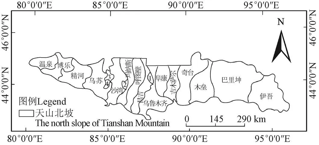
1.五家渠 2.石河子 3.奎屯 4.独山子
1.2 数据来源
1.2.1 遥感数据
使用2004—2015年的MODIS C6的MOD17A3H的NPPA遥感数据产品,共12a,空间分辨率为500 m×500 m,该数据克服了原MODIS_C5数据由于卫星传感器老化而造成的数据衰减和失真现象[18],使用最新的C6产品数据可减少数据本身所带来的误差。文中MOD17A3H遥感数据采用MRT软件进行镶嵌、格式转换和重投影等操作,然后利用ENVI与ArcGIS软件,结合研究区矢量数据对研究区进行裁剪。
1.2.2 气象数据
选取2004—2015年天山北坡及其附近地面气象站的逐月平均气温及逐月降水量数据资料,该数据来源于中国气象数据网(http://data.cma.cn/)。为了得到研究区时间序列为年的气象数据空间分布图,首先将各气象站点的月数据信息合成年数据信息,并利用澳大利亚专业气象数据插值工具ANUSPLINA以经纬度作为自变量[19],高程作为协变量,对研究区年均温、年降水量进行空间插值,所有气象栅格数据的行列数、像元大小及投影方式均与遥感数据一致。
1.2.3 野外实测数据
于2015年7月15日、7月24日、8月10日、8月17日和8月26日,在天山北坡中段农牧区,即在牧场草地生长期对草地地上生物量进行采集,分别在阳坡和阴坡设置采样点。根据实际情况选取一定数量的1 m×1 m样方,在试验区每隔100 m重复的点采样3次,其平均值作为样本值,共计78个样本。齐地剪取样方地上生物量,剪取样本的同时用手持GPS定位仪,记下单位样方的经纬度,样本装袋并编号统一带回实验室称量。样本数据的详细信息主要包括生物量干质量、湿质量、样点坐标、高程、覆盖度、经纬度、海拔、时间等。
2 研究方法
2.1 植被净初级生产力的计算方法
NPPA代表受气候变化和人类活动共同作用后的实际净初级生产力。NPPP表示受气候因素影响下的潜在植被净初级生产力。NPPH表示人类活动对植被净初级生产力的影响。
NPPA数据来源于MODIS遥感影像的MOD17A3H产品,提供的年度净初级生产力数据。
NPPP以周广胜等[22-24]建立的自然净初级生产力模型为基础,该模型以植被进行光合作用的蒸散量模型为基础,综合考虑了诸因子间的相互作用,计算公式如下
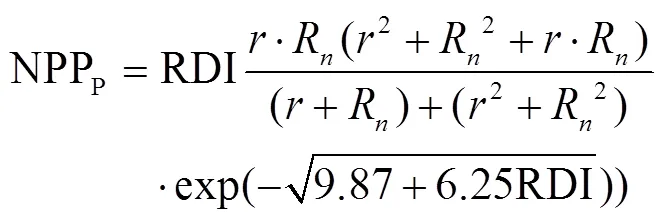
进一步化简得


式中NPPP为气候因素驱动下的潜在净初级生产力(g/m2·a);RDI为辐射干燥度;R为年净辐射(mm);为年降水量(mm);PER为年可能蒸散率;PET为年可能蒸散量(mm);BT为年平均生物温度(oC);为0~30oC的月均温(oC)。
NPPH利用NPPA与NPPP之间的差值来计算人类活动对净初级生产力的影响[13,25],计算公式如下

NPPH为正值表明人类活动对天山北坡净初级生产力具有正作用;反之,则表示具有负作用。根据NPPH大小及其斜率变化趋势,将人类活动对天山北坡净初级生产力的影响分为4类:正作用增强、正作用减弱、负作用增强、负作用减弱。
2.2 变化趋势分析方法
利用最小二乘法来估算每个像元NPPA和NPPH随时间变化的线性趋势[26-28],这种方法被广泛应用于植被遥感分析中。其计算公式如下

式中表示年数,NPP为某一像元点第年的NPPA或NPPH值,slope为像元点的趋势线斜率,若slope>0表示变化趋势为增加,slope<0表示变化趋势为减小,slope=0则表示没有变化。
2.3 气候变化对NPPA影响分析方法
在多因子影响环境中,常用偏相关系数进行衡量。偏相关系数是指控制一个变量不变的前提下研究另外两个变量之间的相关性[29-30]。为了计算偏相关系数,首先计算相关系数,计算公式如下


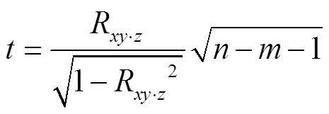
式中分别代表自变量个数和样本数。
3 结果与分析
3.1 NPPA数据验证
MOD17A3H提供的年度NPPA数据,简称NPPA模拟值,通过实测生物量数据对该数据进行验证。根据2016年天山北坡采集的78个草地实测生物量样本,对MOD17A3H NPPA数据进行精度验证。采用实测生物量换算为NPPA数据,根据生物量与NPPA之间的转换系数0.475,进而得到采样点实测NPPA数据[20]。由于采样时间为7、8月,年度植被最为旺盛的时期,NPPA值可以代表年度NPPA值[21],将实测数据的样本生物量位置实测值与MOD17A3H NPPA对应位置模拟值进行拟合,如图 2所示,结果表明,NPPA模拟值与NPPA实测值基本吻合(2=0.811 7,<0.01)。因此,利用MOD17A3H NPPA数据对研究区NPPA模拟具有可行性。
3.2 2004—2015年NPPA变化分析
2004—2015年天山北坡NPPA总体上呈缓慢增长趋势,如图3所示,天山北坡NPPA年总量在14.74~19.53 Tg(1 Tg=1012g)之间;NPPA年均值在128.67~170.49 g/(m2·a)之间,多年均值为144.71 g/(m2·a),NPPA最大值出现在2013年,达到170.49 g/(m2·a),最小值则在2008年,为128.67 g/(m2·a)。
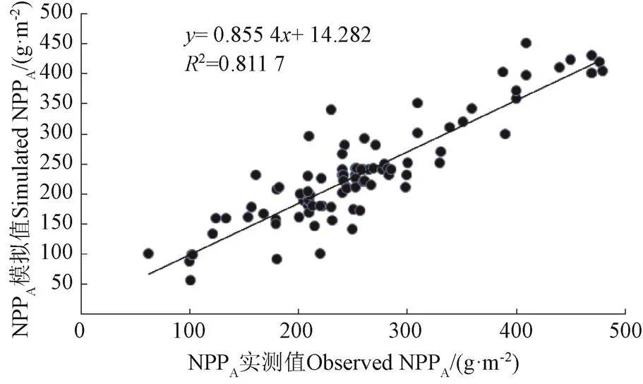
图2 天山北坡草地NPPA模拟值与实测值的比较
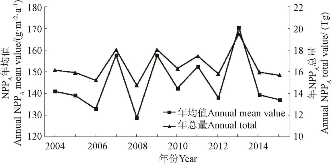
图3 天山北坡2004—2015年NPPA总量和均值
不同区域NPPA空间分布呈现显著差异,如图4所示,整体上NPPA呈西高东低的趋势,具体表现为:天山北坡西部NPPA年均值为179.69 g/(m2·a),年总量为3.78 Tg,高值区主要分布在温泉县东部及博乐市西部区域,介于350~510g/(m2·a)之间,其低值区主要分布在精河县北部地区;天山北坡中部区域NPPA年均值为135.62 g/(m2·a),年总量为11.74 Tg,NPPA高值区主要沿天山一带分布,其值介于330~550 g/(m2·a)之间,低值区主要分布在奇台县和木垒县北部区域;天山北坡东部大部分为荒漠地区,有植被区域主要零星分布在巴里坤的东南部及伊吾县的西南部少量区域,NPPA年均值为152.00 g/(m2·a),虽然东部NPPA年均值高于中部,但是东部有植被区域总面积仅占6.07 %,因此NPPA总量依然很低,仅为1.06 Tg,高值区主要分布在巴里坤东南部,其值介于300~450 g/(m2·a)之间。
总体上,中西部区域是天山北坡NPPA的主要供给区,NPPA总量占天山北坡的94%,中西部区域也是天山北坡典型的天然草场与农作物种植分布区,独特的自然环境给予植被相对适宜的生长条件,促使植被进行光合作用转化为更多的有机质。
3.3 2004—2015年气候因子与NPPA的关系
根据天山北坡附近区域气象站点的年平均气温及年累积降水量统计数据,分析年平均降水量和年平均温度与NPPA的关系。如图5所示:天山北坡2004—2015年平均气温在-15.25~11.14 ℃之间,多年均值为4.98 ℃,其中2006年平均气温最高,为5.96 ℃,最小值在2014年,为3.92 ℃;年累积降水量在31.20~1214.38 mm之间,多年均值为294.63 mm,年降水量最高值在2015年,为397.57 mm,最低值在2008年,为189.73 mm。整体上,近12年来天山北坡年平均气温呈下降趋势,趋势变化率为-0.10 ℃/a,年降水量呈上升趋势,趋势变化率为9.17 mm/a。
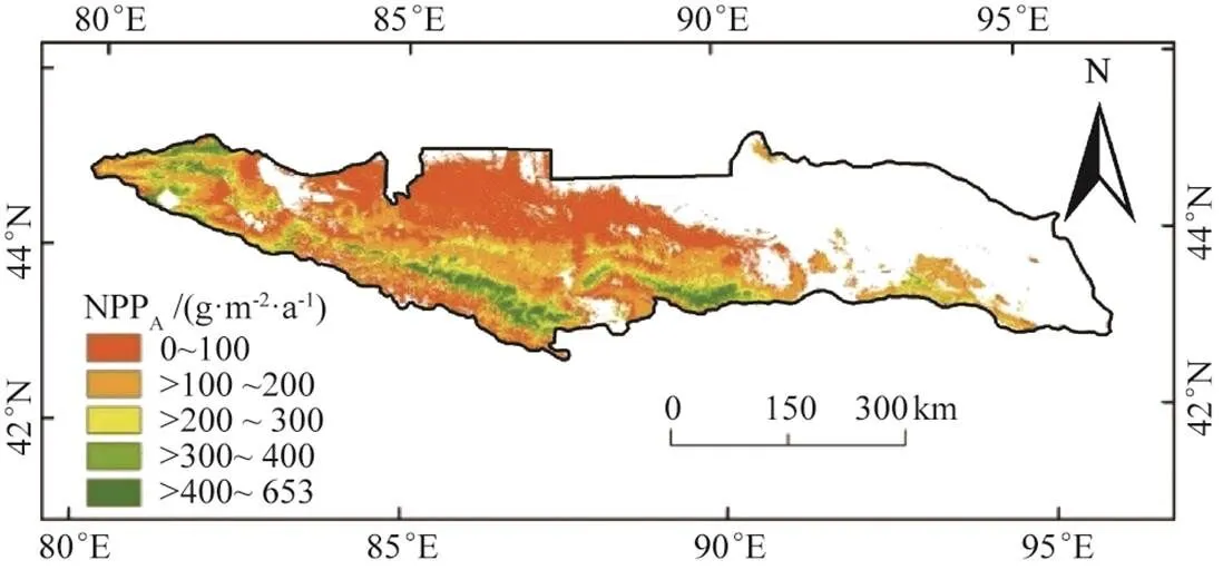
注:白色区域为未利用地。下同。
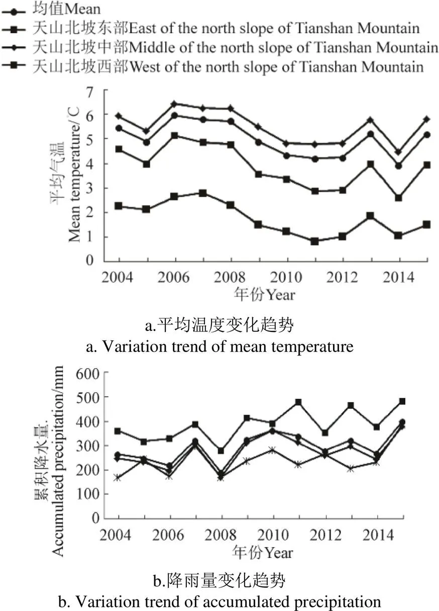
图5 2004—2015天山北坡气温和累积降水量变化
由于研究区地理位置横跨多个经度,受海拔及其地形地貌特征的影响,天山北坡东西部气候差异较大,东部区域年均温及年降水量最低,分别为1.77 ℃、240.41 mm;中部区域年均温最高,为5.51 ℃,年降水量为276.54 mm;西部区域年降水量最高,为387.10 mm,年均温为3.89 ℃;天山北坡东部气温及降水量趋势变化率分别为-0.13 ℃/a、8.89 mm/a;中部区域气温及降水量变化速率最慢,趋势变化率分别为-0.09 ℃/a、8.70 mm/a;西部区域气温及降水量变化速率最快,趋势变化率分别为-0.15 ℃/a、11.21 mm/a。
在多因子影响环境中,采用偏相关系数来表示两要素之间的相关程度,2004—2015年天山北坡NPPA与年均温、年降水量之间的平均相关系数分别为0.05、0.30,如图6所示,NPPA与年均温呈正、负相关的区域分别为研究区总面积的55.49%、44.51%。呈正相关的区域主要分布在乌鲁木齐市、阜康市、吉木萨尔县、奇台县、木垒县南部和温泉县西部,呈负相关的区域主要分布在伊吾县、巴里坤县、乌苏市、奎屯市、以及昌吉市至沙湾县以北区域;由检验结果可知,有1.28%的区域通过了<0.01水平的显著性检验,主要分布在乌鲁木齐市和木垒县境内。NPPA与年降水量呈正、负相关的区域分别占总面积的86.03%、13.97%,呈正相关的区域基本遍布整个研究区,呈负相关区域主要分布在博乐市及天山北坡南部部分区域;有3.89%的区域通过了<0.01水平的显著性检验,主要分布在温泉县、伊吾县及巴里坤县部分区域。整体而言,2004—2015年天山北坡NPPA与降水的相关性大于温度。
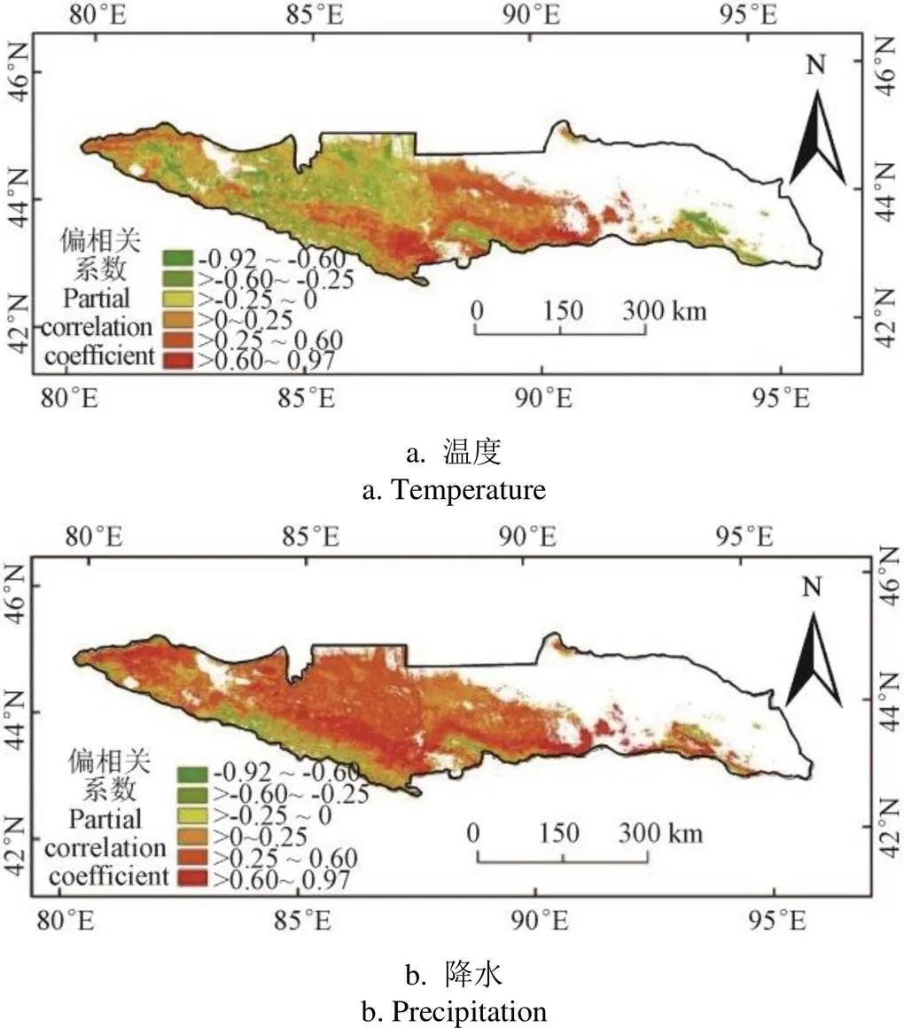
图6 2004—2015年天山北坡NPPA与温度、降水偏相关系数空间分布
降水对天山北坡NPPA的影响大于温度,主要因为研究区内86.03%的区域与降水量呈正相关,其中呈显著相关的区域主要集中在东部地区,因为东部大部分为荒漠地区,植被对降水的敏感性较高;研究内与温度呈正相关的区域占55.49%,其中呈显著性相关的区域主要集中在乌鲁木齐市和木垒县境内。
3.4 2004—2015年人类活动与NPPH的关系
根据天山北坡2004—2015年均NPPH空间分布,如图7所示,人类活动对NPP的作用变化范围为-163.44~543.74 g/(m2·a),多年均值为13.72 g/(m2·a)。人类活动正作用影响的区域(NPPH>0)占44.15%,主要分布在伊吾县、巴里坤县、温泉县东部及天山北坡南部沿天山一带;负作用影响的区域占55.85%,主要分布在天山北坡中部以北区域,其为典型的天然牧场和农作物种植分布区。
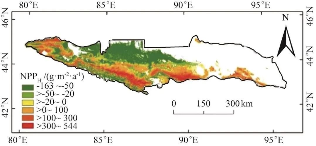
图7 2004—2015年天山北坡平均NPPH的空间格局
由2004—2015年人类活动对天山北坡NPPH影响的年际变化斜率(图8a),NPPH年际变化值slope介于-33.66~28.44 g/(m2·a)之间,平均变化速率为-1.24 g/(m2·a),其中增加速度最快的区域是温泉县中东部及博乐市中西部,增加速度最慢的区域是伊吾县、巴里坤县和木垒县南部,减少速度最快的区域是博乐市东部,减少速度最慢的是天山北坡中段北部区域。
根据天山北坡人类活动对NPPH的作用分类空间格局,如图8b所示,人类活动正作用不断增强的区域占17.78%,主要分布在奇台县、木垒县和天山北坡东部部分区域;人类活动正作用不断减弱的区域占26.38%,主要分布在乌鲁木齐市、呼图壁县和昌吉市南部区域;人类活动负作用不断增强的区域占5.91%,零星分布在奎屯市及乌苏市部分区域;人类活动负作用不断减弱的区域占49.94%,主要分布在博乐市、精河县和天山北坡中段以北区域。
人类活动对天山北坡NPPH的影响总体呈现下降趋势,其中人类活动对植被的负作用大于正作用,原因主要是随着天山北坡的不断发展,水土资源不合理开发及过度放牧等行为的严重加剧,导致植被开始退化,NPPH总量降低。人类活动正作用不断增强的区域主要分布在中东部区域,原因主要为中东部区域荒漠未利用地面积较大,随着西部大开发进程的推进,退耕还林还草,退牧还草等生态恢复政策的实施,使得中东部区域绿洲面积不断扩大,NPPH总量开始出现上升。负作用不断增强的区域零星分布在奎屯市及乌苏市部分地区,该区域为人类活动的密集区,人为要素干扰日益加剧,促使植被不断退化。人类活动负作用不断减弱的区域面积最广,占49.94%,主要分布在天山北坡中段北部地区及博乐市和精河县,说明总体上人为要素对天山北坡NPPH的负面影响开始出现改善,得益于近年来农作物种植区膜下滴灌、高压渗灌等节水技术的实施,为原处于干旱区的水资源合理利用提供技术支撑。此外,由于天山北坡区域自然生态保护区的建立和政府部门出台的生态保护政策的实施,也对天山北坡生态环境的恢复起到积极作用。
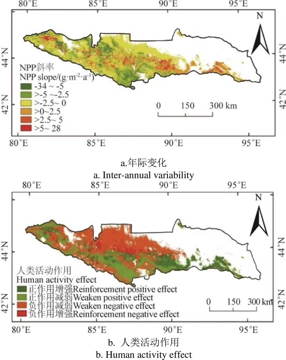
图8 天山北坡NPPH年际变化及其作用的空间格局
4 结 论
利用长时间序列的MODIS C6 NPP遥感数据、气象数据和野外实测数据,定量分析了2004—2015年气候变化和人类活动对天山北坡净初级生产力变化的影响,结论如下:
1)天山北坡2004—2015年实际净初级生产力NPPA整体上呈现缓慢上升趋势,NPPA年均值波动范围在128.67~170.49 g/(m2·a)之间,多年均值为144.71 g/(m2·a);不同区域NPPA空间特征差异明显,西部区域NPPA年均值最高,中西部区域是天山北坡NPPA的主要供给区。
2)天山北坡NPPA与温度呈正相关的区域占55.49%,有1.28%的区域通过了<0.01水平的显著性检验,主要分布在乌鲁木齐市和木垒县境内;与降水呈正相关的区域占86.03%,有3.89%的区域通过了<0.01水平的显著性检验,主要分布在温泉县、伊吾县及巴里坤县部分地区。降水对天山北坡NPPA年际变化的影响大于温度。
3)天山北坡人类活动影响的净初级生产力年均值波动范围为-163.44~543.74 g/(m2·a),多年均值为13.72 g/(m2·a),年均变化速率为-1.24 g/(m2·a),其中人类活动正作用影响区域占44.15%,主要分布在伊吾县、巴里坤县、温泉县东部及天山北坡南部沿天山一带;负作用影响区域占55.85%,主要分布在天山北坡中部以北区域。人类活动对天山北坡净初级生产力的影响趋势逐渐向促进作用方向发展,人类活动正作用不断增强的区域主要分布在天山北坡中东部,负作用不断增强的区域零星分布在奎屯市及乌苏市部分区域。
[1] Field C B, Behrenfeld M J, Randeson J T, et al. Primary production of the biosphere: Integrating terrestrial and oceanic components[J]. Science, 1998, 281: 237-240.
[2] Cramer W, Field C B. Comparing global models of terrestrial net primary productivity(NPP): Introduction[J]. Global Change Biology, 1999, 5(1): 46-55.
[3] Lieth H. Whittaker R H. Primary Productivity of the Biosphere[M]. New York: Springer, 1975.
[4] Gao T, Xu B, Yang X C, et al. Aboveground net primary productivity of vegetation along a climate related gradient in a Eurasian temperate grassland: Spatiotemporal patterns and their relationships with climate factors[J]. Environmental Earth Sciences, 2017,1: 56 -76.
[5] Michaletz S T, Cheng D L, Kerkhoff A J, et al. Convergence of terrestrial plant production across global climate gradients[J]. Nature, 2014, 512(7512): 39-53.
[6] Twine T E, Kucharik C J. Climate impacts on net primary productivity trends in natural and managed ecosystems of the central and eastern United States[J]. Agricultural and Forest Meteorology, 2009, 149(12): 2143-2161.
[7] 王新闯,王世东,张合兵.基于MOD17A3的河南省NPP时空格局[J].生态学杂志,2013,32(10):2797-2805. Wang Xinchuang, Wang Shidong, Zhang Hebing. Spatiotemporal pattern of vegetation net primary productivity in Henan Province of China based on MOD17A3[J]. Chinese Journal of Ecology, 2013, 32(10): 2797-2805. (in Chinese with English abstract)
[8] 潘竟虎,黄克军,李真.2001-2010年疏勒河流域植被净初级生产力时空变化及其与气候因子的关系[J]. 生态学报,2016,37(6):1888-1899. Pan Jinghu, Huang Kejun, Li Zhen. Spatio-temporal variation in vegetation net primary productivity and its relationship with climatic factors in the Shule River basin from 2001 to 2010[J]. Acta Ecologica Sinica, 2016, 37(6): 1888-1899. (in Chinese with English abstract)
[9] 谢宝妮,秦占飞,王洋,等.黄土高原植被净初级生产力时空变化及影响因素[J].农业工程学报,2014,30(11):244-253. Xie Baoni, Qin Zhanfei, Wang Yang, et al. Spatial and temporal variation in terrestrial net primary productivity on Chinese Loess Plateau and its influential factors[J]. Transactions of the Chinese Society of Agricultural Engineering (Transactions of the CSAE), 2014, 30(11): 244-253. (in Chinese with English abstract)
[10] 国志兴,王崇明,刘殿伟,等.三江平原农田生产力时空特征分析[J].农业工程学报,2009,25(1):249-254. Guo Zhixing, Wang Chongming, Liu Dianwei, et al. Analysis of temporal and spatial features of farmland productivity in the Sanjiang plain [J]. Transactions of the Chinese Society of Agricultural Engineering (Transactions of the CSAE), 2009, 25(1): 249-254. (in Chinese with English abstract)
[11] 高军,尹小君,汪传建,等. 天山北坡植被NPP时空格局及气候因子驱动分析[J].新疆农业科学,2018,55(2):352-361. Gao Jun, Yin Xiaojun, Wang Chuanjian, et al. Spatial-temporal distribution of NPP and its climatic driving factors in the Northern Slope of Tianshan Mountain[J]. Xinjiang Agricultural Science, 2018, 55(2): 352-361. (in Chinese with English abstract)
[12] 苏伟,刘睿,孙中平,等.基于SEBAL模型的农作物NPP反演[J].农业机械学报,2014,45(11):272-279. Su Wei, Liu Rui, Sun Zhongping, et al. Crop NPP inversion using surface energy balance algorithm for land model [J]. Transactions of the Chinese Society for Agricultural Machinery, 2014, 45(11): 272-279. (in Chinese with English abstract)
[13] 高清竹,万运帆,李玉娥,等.藏北高寒草地NPP变化趋势及其对人类活动的响应[J].生态学报,2007,27(11):4612-4619. Gao Qingzhu, Wan Yunfan, Li Yu’e, et al. Trends of grassland NPP and its response to human activity in Northern Tibet [J]. Acta Ecologica Sinica, 2007,27(11): 4612-4619. (in Chinese with English abstract)
[14] Nemani R R, Keeling C D, Hashimoto H, et al. Climate-driven increases in global terrestrial net primary production from 1982 to 1999[J]. Science, 2003, 300(5625): 1560-1563.
[15] 赵鹏,陈桃,王茜,等.气候变化与人类活动对新疆草地生态系统NPP影响的定量分析[J].中国科学院大学学报,2020,37(1):51-62. Zhao Peng, Chen Tao, Wang Qian, et al. Quantitative analysis of the impact of climate change and human activities on NPP of grassland ecosystem in Xinjiang[J]. Journal of the University of Chinese Academy of Sciences, 2020, 37(1): 51-62. (in Chinese with English abstract)
[16] 信忠保,许炯心,郑伟.气候变化和人类活动对黄土高原植被覆盖变化的影响[J].中国科学D辑:地球科学,2007,37(11):1504-1514.
[17] 张珺,任鸿瑞. 人类活动对锡林郭勒盟草原净初级生产力的影响研究[J].自然资源学报,2017,32(7):1125-1133. Zhang Jun, Ren Hongrui. Effects of human activities on net primary productivity in the Xilingol Grassland [J]. Journal of Natural Resources, 2017, 32(7): 1125-1133. (in Chinese with English abstract)
[18] 王强,张廷斌,易桂花,等.横断山区2004-2014年植被NPP时空变化及其驱动因子[J].生态学报,2017,37(9):3084-3095. Wang Qiang, Zhang Tingbin, Yi Guihua, et al. Tempo-spatial variations and driving factors analysis of net primary productivity in the Hengduan mountain area from 2004 to 2014 [J]. Acta Ecologica Sinica, 2017, 37(9): 3084-3095. (in Chinese with English abstract).
[19] Meng J H, Wu B F, Du X. Method to construct high spatial and temporal resolution NDVI dataset-STAVFM[J]. Journal of Remote Sensing, 2011, 15(1): 44-59.
[20] 穆少杰,李建龙,周伟,等.2001—2010年内蒙古植被净初级生产力的时空格局及其与气候的关系[J].生态学报,2013,33(12):3752-3764. Mu Shaojie, Li Jianlong, Zhou Wei, et al. Spatial-temporal distribution of net primary productivity and its relationship with climate factors in Inner Mongolia from 2001 to 2010 [J]. Acta Ecologica Sinica, 2013, 33(12): 3752-3764. (in Chinese with English abstract)
[21] 吴晓全,王让会,李成,等. 天山植被NPP时空特征及其对气候要素的响应[J].生态环境学报,2016,25(11):1848-1855. Wu Xiaoquan, Wang Ranghui, Li Cheng, et al. Spatial-temporal characteristics of NPP and its response to climatic factors in Tianshan Mountains Region [J]. Ecology and Environment Sciences, 2016, 25(11): 1848-1855. (in Chinese with English abstract)
[22] 周广胜,张新时.全球气候变化的中国自然植被的净第一性生产力研究[J].植物生态学报,1996,20(1):11-19. Zhou Guangsheng, Zhang Xinshi. Study on NPP of natural vegetation in China under global climate change [J]. Chinese Journal of Plant Ecology, 1996, 20(1): 11-19. (in Chinese with English abstract)
[23] 周广胜,张新时.自然植被净第一性生产力模型初探[J].植物生态学报,1995,19(3):193-200. Zhou Guangsheng, Zhang Xinshi. A natural vegetation NPP model [J]. Acta Phytoecologica Sinica, 1995, 19(3): 193-200. (in Chinese with English abstract)
[24] 周广胜,郑元润,陈四清,等.自然植被净第一性生产力模型及其应用[J].林业科学,1998(5):4-13. Zhou Guangsheng, Zheng Yuanrun, Chen Siqing, et al. NPP model of natural vegetation and its application in China [J]. Scientia Silvae Sinicae, 1998(5): 4-13. (in Chinese with English abstract)
[25] 赵鹏,陈桃,王茜,等.气候变化和人类活动对新疆草地生态系统NPP影响的定量分析[J].中国科学院大学学报,2020,37(1):51-62. Zhao Pen, Chen Tao, Wang Xi, et al. Quantitative analysis of the impact of climate change and human activities on grassland ecosystem NPP in Xinjiang[J].Journal of the University of Chinese Academy of Sciences, 2020, 37(1): 51-62. (in Chinese with English abstract)
[26] 李辉霞,刘国华,傅伯杰.基于NDVI的三江源地区植被生长对气候变化和人类活动的响应研究[J].生态学报,2011,31(19):5495-5504. Li Huixia, Liu Guohua, Fu Bojie. Response of vegetation to climate change and human activity based on NDVI in the Three-River Headwaters region [J]. Acta Ecologica Sinica, 2011, 31(19): 5495-5504. (in Chinese with English abstract)
[27] Stow D, Daesehner S, HoPe A, et al. Variability of the seasonally integrated normalized difference vegetation index across the north slope of Alaska in the 1990s[J].International Journal of Remote Sensing, 2003, 24: 1111-1117.
[28] 金凯,王飞,韩剑桥,等.1982-2015年中国气候变化和人类活动对植被NDVI变化的影响[J].地理学报,2020,75(5):961-974. Jin Kai, Wang Fei, Han Jianqiao, et al. Contribution of climatic change and human activities to vegetation NDVI change over China during 1982-2015[J].Acta Geographica Sinica, 2020, 75(5): 961-974. (in Chinese with English abstract)
[29] 徐建华.现代地理学中的数学方法[M]. 北京:高等教育出版社,2002.
[30] 张戈丽,徐兴良,周才平,等.近30年来呼伦贝尔地区草地植被变化对气候变化的响应[J].地理学报,2011,66(1):47-58. Zhang Geli, Xu Xingliang, Zhou Caiping, et al. Responses of vegetation changes to climatic variations in Hulun Buir Grassland in past 30 years [J]. Acta Geographica Sinica, 2011, 66(1): 47-58. (in Chinese with English abstract)
Effects of climate change and human activities on net primary productivity in the Northern Slope of Tianshan, Xinjiang, China
Yin Xiaojun1, Zhu Honghui2※, Gao Jerry3, Gao Jun4, Guo Lijie1, Wang Jiaojiao1
(1.,,832000,; 2.,,832000,; 3.,,95192,4,,230000,)
The northern slope of Tianshan has become an important development base of agriculture and animal husbandry, particularly for the key area of “one belt, one road”. The investigation of Net primary productivity (NPP) in this area is absolutely essential to the sustainable development of agriculture and animal husbandry, due to the NPP can serve as a significant indicator of ecological environment evaluation. However, most previous studies of NPP mainly focused on the simulation of NPP under a model in a specific period. Therefore, this study aims to analyze the change of NPP from 2004 to 2015, and further investigate the impact of climate change and human activities on the NPP change. The remote sensing image data in the long time series was used to quantify the global variation of NPP subjected to the climate change and human activities. The specific procedure was as follows: First, the image data collected from a MODIS C6 remote sensing was used to simulate the actual net primary productivity (NPPA) for 12 years, and the simulated NPPAwas verified by biomass data measured from the field, indicating that the MODIS C6 remote sensing data was feasible to simulate NPPA. Then, the change trends of temperature, precipitation, and NPPAwere analyzed in the past 12 years, to clarify the influence of temperature and precipitation on NPPA.Finally, the net primary productivity (NPPH) was selected to explain the effect of human activities on the Northern Slope of Tianshan. The results show that: the actual NPPAat the Northern Slope of Tianshan ranged from 128.67 to 170.49 g/(m2·a) from the period of 2004 to 2015, with an average annual value of 144.71 g/(m2·a). There were obvious differences in the spatial characteristics of NPPAin different regions, showing a trend of high in the West and low in the East. The annual average of NPPAin the western region was the highest, indicating that the central and western regions were the main supply areas of NPPAon the Northern Slope of Tianshan. Specifically, the change rates of temperature and precipitation in the East were -0.13 ℃/a and 8.89 mm/a, whereas, those in the central region were the smallest, with the change rates of -0.09 ℃/a and 8.70 mm/a, and those in the western region were the largest, with the change rates of-0.15 ℃/a and 11.21 mm/a, respectively. It infers that the effect of precipitation on NPPAwas greater than that of temperature. The average of annual NPPHon the northern slope of Tianshan ranged from -163.44-543.74 g/(m2·a), with an annual average of 13.72 g/(m2·a), while an average annual change rate of-1.24 g/(m2·a). Specifically, 44.15% of them were affected by the positive human activities, mainly distributed in Yiwu, Balikun, Wenquan county, and the south of North Slope of Tianshan along the Tianshan Mountain; 55.85% of negative impact areas were mainly distributed in the north and central part of the north slope of Tianshan. The influence of human activities on NPP change was gradually developing towards the direction of promoting effect in the northern slope of Tianshan. The typical areas triggered by increasing human activities were mainly distributed in the middle and east of the northern slope of Tianshan, while, the areas of increasing negative effects were scattered in Kuitun and Wusu County. The finding can provide a new way to explore the spatial pattern, process, and function of NPP under natural and human disturbance.
remote sensing; climate change; NPP; human activities; the Northern Slope of Tianshan; MODIS C6
尹小君,祝宏辉,Gao Gerry,等. 气候变化和人类活动对天山北坡净初级生产力变化的影响[J]. 农业工程学报,2020,36(20):195-202.doi:10.11975/j.issn.1002-6819.2020.20.023 http://www.tcsae.org
Yin Xiaojun, Zhu Honghui, Gao Jerry, et al. Effects of climate change and human activities on net primary productivity in the Northern Slope of Tianshan, Xinjiang, China[J]. Transactions of the Chinese Society of Agricultural Engineering (Transactions of the CSAE), 2020, 36(20): 195-202. (in Chinese with English abstract) doi:10.11975/j.issn.1002-6819.2020.20.023 http://www.tcsae.org
2020-06-23
2020-09-28
国家重点研发计划项目(2016YFB0504203);石河子大学国际合作项目(GJHZ201905)
尹小君,博士,副教授,主要研究方向资源环境遥感研究。Email:yinxiaojun2018@163.com
祝宏辉,博士,二级教授,主要研究方向生态遥感。Email:zhuhonghui1973@163.com
10.11975/j.issn.1002-6819.2020.20.023
S127
A
1002-6819(2020)-20-0195-08

