Spatial Analyses of An Integrated Landscape-seascape Territorial System:The Case of The Overcrowded Gulf of Naples,Southern Italy
Luca Appolloni,Roberto Sandulli,Carlo Nike Bianchi,Giovanni Fulvio Russo
1Marine Ecology Laboratory,Department of Science and Technology,Parthenope University of Naples,Centro Direzionale,Isola C4,80143 Napoli,Italy
2CoNISMa,Piazzale Flaminio 9,00197 Rome,Italy
3Department of Earth,Environmental and Life Sciences,University of Genova,Corso Europa 26,16132 Genova,Italy
Keywords Landscape accounting Landscape metrics Multivariate analyses γ-variability Heterogeneity
Abstract Landscape ecology investigates spatial patterns of natural and anthropogenic ecosystems(anthromes).However,most studies were focused on terrestrial environment,while submarine landscape(seascape)was poorly taken into account.This study represents a first attempt to perform an integrated landscape/seascape spatial analysis of the densely populated Gulf of Naples.Multivariate analyses on landscape metrics were used to detect differences in the spatial patterns of ecosystem patches between landscape and seascape and to compare the effects of anthropogenic impact in terms of spatial heterogeneity.Results showed that landscape,mainly composed by humans perturbed ecosystems,presents higher patch edge dimension,diversity and evenness,and a lower fractal dimension than seascape.Significant differences on edges,diversity metrics,and heterogeneity among patches were also detected between land-and seascape.Landscapeshowed lowγ-variability(a measure of heterogeneity)due to the highly homogenous distribution of ecosystem patches,a characteristic feature of impacted anthropogenic system with low resilience.Conversely,seascape showed highγ-variability,a feature of systems with low anthropogenic impact and high resilience.These outcomes suggest that anthropogenic impact on integrated territorial systems is inversely related toγ-variability,and consequently to resilience.In addition,they also suggest that seascape is more resilient than landscape,also in a highly exploited and overcrowded territorial system like the Gulf of Naples.Such findings can also be useful in support of environmental accounting and management at landscape scale.
1 Introduction
The study of landscape focuses on ecological patterns and processes that spatially structure mosaics of ecosystems(Turner et al.,2001)whose heterogeneity and complexity affect species distribution and persistence(Fahrig and Nuttle,2005).
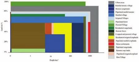
Fig.1 Anthromes classification based on population density(logarithmic scale)and land use(percentage of used land area).Data from Ellis and Ramankutty(2008).
A recent development in community ecology concerns the concept of meta-community:a set of local communities connected by dispersal of multiple potentially interacting species at landscape or regional scale(Mouquet and Loreau,2003).In this framework,variation of species at assemblage level(β-diversity)is detected through changes occurring among sample units at a given environmental extent.In particular,β-diversity measures changes of intrinsic heterogeneity in species composition between adjacent communities(Anderson et al.,2011)both at medium scale(Semprucci and Balsamo,2012;Sandulli et al.,2014;Semprucci et al.,2016)and macro scale(Bevilacqua et al.,2012;Appolloni et al.,2017;Donnarumma et al.,2018a).Thus,under the metacommunity perspective,the focus is placed on structural and dynamical properties arising from a broad spatial scale,as the result of the reciprocal connections among the components of local communities.
One of the limitation of the meta-community concept is the exclusive focus on the biotic component,while it is also important to embed the abiotic compartment of ecosystems,thus also including abiotic constraints and feedback(Sterner and Elser,2002).Therefore,a meta-ecosystem can be considered as a set of ecosystems connected by spatial flows of energy,materials,and organisms(Loreau et al.,2003).These flows are affected by spatial distribution of ecosystems patches(Hansson et al.,1995)measured in terms ofγ-variability(Wang and Loreau,2014),assessed by landscape metrics and related to the stability of meta-ecosystems as resilience(Montefalcone et al.,2011;Oliver et al.,2015).
On land,natural biomes are composed by wild ecosystems forming landscapes,according to climate patterns(Olson et al.,2001)if human in fluences are negligible(Martin et al.,2014).In high densely populated areas,new biomes are generated by humans and classified on land use and population density(Fig.1).These anthropogenic biomes,called “anthromes”,represent further elements of land fragmentation(Ellis and Ramankutty,2008;Václavík et al.,2013).
Anthromes,coherently with the concept of biome,are characterized by anthropogenic landscapes(Fig.2),in turn composed by ecosystems shaped by building settlements and infrastructures,driven by cultural history and environmental constraints(Pickett and Cadenasso,1995),and delivering a number of ecosystem services vital for human well-being(Häyhä and Franzese,2014;Nikodinoska et al.,2018).
In the sea,underwater bottom landscape(seascape)is often perceived to be in more natural or semi-natural conditions(Bianchi et al.,2005)and the idea of marine anthromes has never fully developed.However,anthropogenic ecosystems along coastal areas strongly affect the marine areas through a number of impacts,such as pollution,eutrophication,sedimentation,resource overexploitation,habitat destruction and diseases(Tallis et al.,2008;Coll et al.,2010;Lotze et al.,2011),resulting in a land-sea integrated system.Consequences of ecosystems fragmentation are similar in seascape and landscape(Worm et al.,2006;Hily and Bernard,2014)since meta-ecosystems are scattered and isolated,with a dramatic reduction of their connectivity(Hovel and Lipcius,2001;Vega Fernandez et al.,2005).
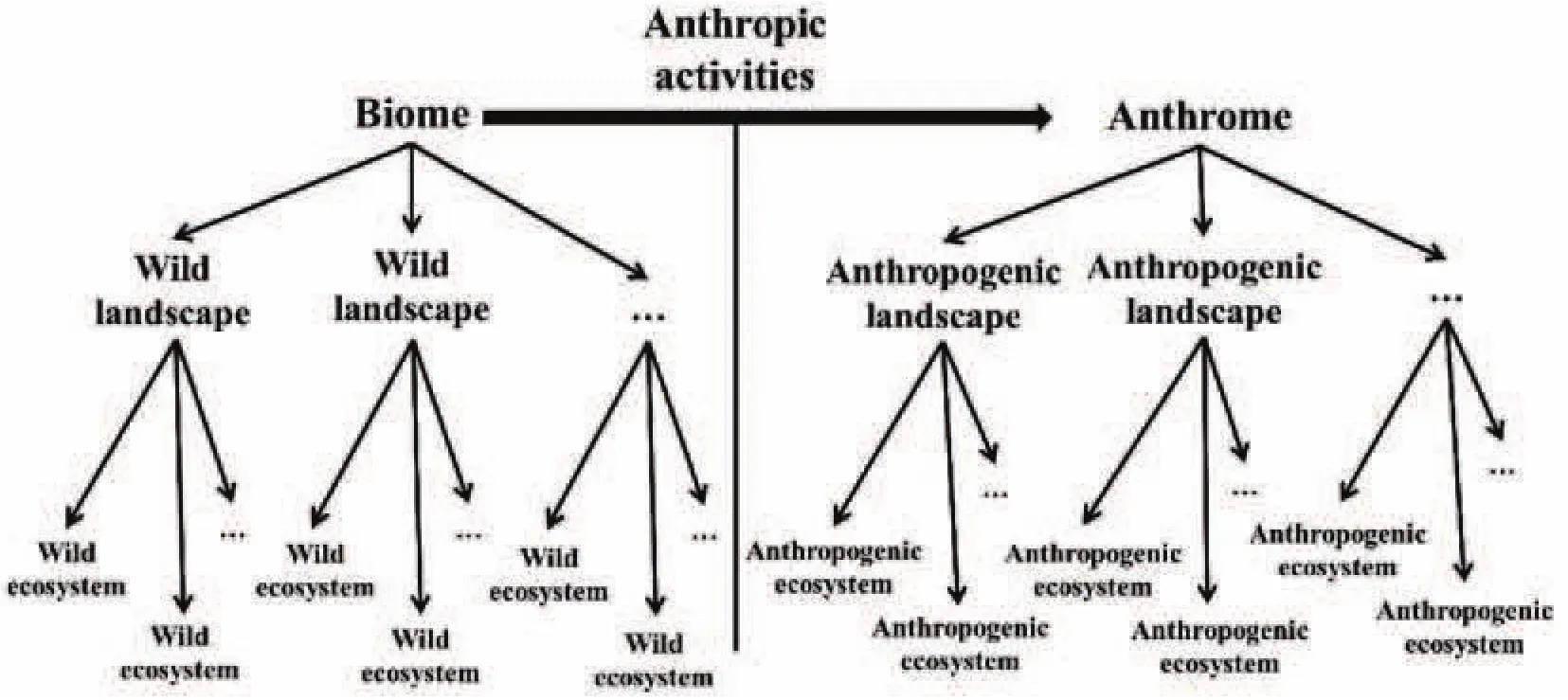
Fig.2 From “biome”to “anthrome”concept.Wild and anthropogeniccomponents of biomes and anthromes are shown in hierarchical order.
In this work,landscape(whose ecological modifications due to anthropogenic impacts are well known)and seascape were analysed together as an integrated territorial system.The degree of naturalness was spatially accounted for through measures of heterogeneity,improving the awareness in management actions.In particular,heterogeneity within and among patches of territory was expressed in terms ofγ-variability,an indirect estimation of ecosystems resilience.
The Gulf of Naples is a very studied site(Appolloni and Russo,2017;Ferrigno et al.,2018a;Donnarumma et al.,2018b)and it was chosen as study area since it is an overcrowded(about an average of 2670 people/km2,with peaks of more than 12000 people/km2)and highly exploited territorial system where landscape and seascape are strongly interconnected and subjected to multiple human pressures(Appolloni et al.,2018a).
2 Materials and methods
2.1 Study area
The terrestrial part(landscape)of the Gulf of Naples(central-southern Tyrrhenian Sea)and its submerged part(seascape)were mapped at scale 1:50,000 and georeferenced using ArcGIS for Desktop 10.1©ESRI.Ecosystems were defined considering their organisms and habitats.
2.1.1 Landscape of the Gulf of Naples
Since landscape ecology studies are often incomplete,being mostly focused on natural areas or carried out at scales of difficult comparison,the Campania Regional Territory Plan(RTP)was used to identify anthropogenic ecosystems composing landscape(Fig.3).The RTP is the first attempt to recognize regional landscapes on the basis of the physical structures,urban settlements,and agricultural and natural areas.However,in those cases where interpretations of RTP maps were ambiguous,ecosystems were assessed through field observations.
In the Gulf of Naples mountain anthromes include major portions of the wild ecosystems,with a complex ecological mosaic of forests,shrublands,and grasslands.These areas are places of typical economic activities related to livestock and tourism,provide environmental services by forest management and maintain local natural equilibrium contributing to the biological diversity and supporting regional ecological network.They also include the main groundwater recharges and represent an important sink of carbon dioxide,contributing to improve the regional balance of greenhouse gas emissions.
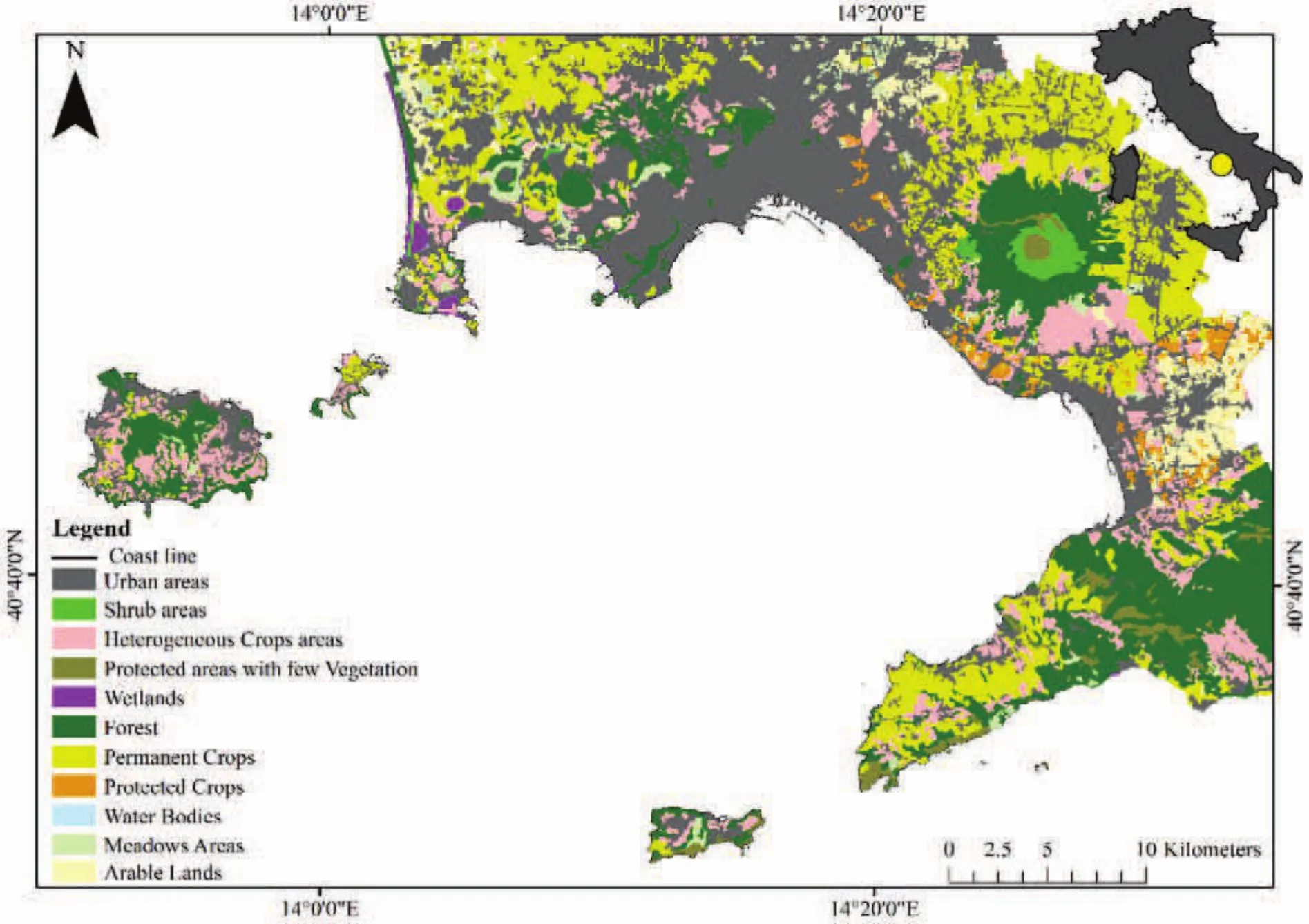
Fig.3 Terrestrial ecosystems map of the Gulf of Naples(from Campania RTP,2008).
Volcanic anthromes are also important parts of cultural and social population history(e.g.,Pompeii archaeological site).Due to the high fertility of their soils,they are characterized by a significant agronomic value with high structural complexity holding wide areas in isolated patches within a human-dominated landscape.Atsmall scale,the interaction of natural,agricultural,and urban areas determines semi-natural ecosystems characterized by aesthetic and recreational values playing a key role as intermediate areas for organisms’diffusion,dispersal,and migration processes.However,in the last forty years these areas have also undergone massive urbanization due to overgrowing tourism,settlements and infrastructures,causing degradation processes(subsidence,saline intrusions in the soil,coastal erosion,instability of cliffs and coastal slopes,and over sedimentation)whose impacts were intensified by significant levels of human pressure on coastal areas,especially where the dynamics of urban sprawl prevailed.Eventually,urban growth and infrastructure development caused the progressive fragmentation of natural areas with a total and progressive deterioration of the agronomic production and aesthetic perception.
2.1.2 Seascape of the Gulf of Naples
The basic map describing the seascape of the Gulf of Naples is from Appolloni et al.(2018b)(Fig.4).The main benthic ecosystems are classified adopting the UNEP RAC/SPA codes(Bellan-Santini et al.,2002;Costello,2009)and then mapped as in other Mediterranean areas(Rovere et al.,2010;Bianchi et al.,2012).In the map bathymetry ranges from the surface to 200 m depth,the conventional limit of continental shelf and of the coastal marine system(neritic zone).However,in the map the upper part of the southern continental slope close to the Marine Protected Area(MPA)“Punta Campanella”was also considered,being characterized by a particular facies of coralligenous bioconstruction,an important habitat of continental shelf providing many ecosystem services(Franzese et al.,2008,2015,2017;Picone et al.,2017;Vassallo et al.,2017).
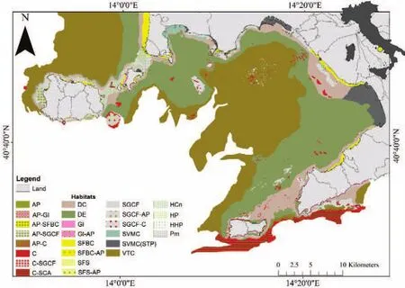
Fig.4 Marine ecosystems map of the Gulf of Naples(from Appolloni et al.,2018b).
The bottom morphology of the northernmost sector is characterized by a rugged bottom,due to the presence of two deep canyons and a large number of rocky outcrops(mostly remains of submarine volcanic cones)that host most of the precious coralligenous habitats(C).The South-East sector is very regular,consisting mostly of a large muddy platform(VTC and DE habitats)that smoothly degrades until 200 m depth even if a single emergent rocky relief is present(Russo,1992,1995).
In shallow bottoms of the northern sector,sandy habitats are present,principally:SFBC,SGCF,GI,and SVMC(Fig.4).The latter habitat shows a facies characterized by strong anthropogenic impacts in the harbours and innermost part of the Gulf(SVMC-STP).In contrast,South-East coast and islands are dominated by high rocky cliffs and boulders,determining suitable sites for infralittoral algal habitat(AP)on the shallow bottoms and for coralligenous bioconstructions on the deeper ones.
The southernmost part of the Gulf hosts the C-SCA habitat,an important coralligenous facies characteristic of the upper part of the continental slope(Ferrigno et al.,2018b).Environmentally and economically important species such as Corallium rubrum(Linnaeus,1758)and other alcyonacea as Paramuricea clavata(Risso,1826)are also present(Bo et al.,2009;Bavestrello et al.,2014;Cattaneo-Vietti et al.,2016).
Around islands,shallow bottoms are mostly covered by seagrass beds of Posidonia oceanica(Delile,1813).There are also evidences of P.oceanica dead mattes in the inner part of the Gulf,as the result of strong anthropogenic pressures(Pergent al.,1995;Costantino et al.,2010).
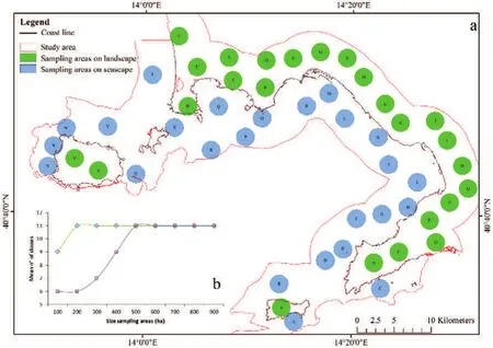
Fig.5 a)Sample areas on landscape and seascape;b)assessment of minimum sample area.
2.2 Data analysis
2.2.1 Patch analysis
Anthropogenic ecosystems and bio-geomorphologic units compose the set of 22 classes on which patch descriptive and multivariate analysis were performed.
Since the coast is the zone where the highest range of seascape variability is concentrated,a buffer area(10 km wide)around the coast was considered as the study area.
Twenty- five random replicates of 500 ha each were considered both on landscape and seascape(Fig.5a)since it is the minimum area where all classes can be detected(Fig.5b).Metrics of landscape and seascape were calculated using Patch analysis for ArcGIS 10.1(Rempel et al.,2012).
Seven landscape statistic metrics describing patches features(Table 1)were calculated since they are suf ficient to interpret landscape patterns composed by anthropogenic ecosystems(Plexida et al.,2014).
2.2.2 Multivariate analysis
Landscape and seascape metrics are square root transformed and compared using multivariate analysis with PRIMERv.6 and PERMANOVA©software(Clarke and Gorley,2006).The design for the analysis involved one factor:Type( fixed,2 levels:Land or Sea),n=25.
In this study,for the first time,a distance-based permutation multivariate analysis of variance,PERMANOVA(Anderson,2001),was carried out on matrix of classes metrics to detect which metrics determine statistical differences among landscape and seascape sample replicates.Permutation tests of multivariate dispersion,PERMDISP(Anderson et al.,2006),based on Euclidian distance were also carried out for the factor Type.
Multivariate dispersion values were employed as a measure ofγ-variability within and between samples of landscape and seascape,thus measuring intrinsic spatial heterogeneity of ecosystems patterns distributions.
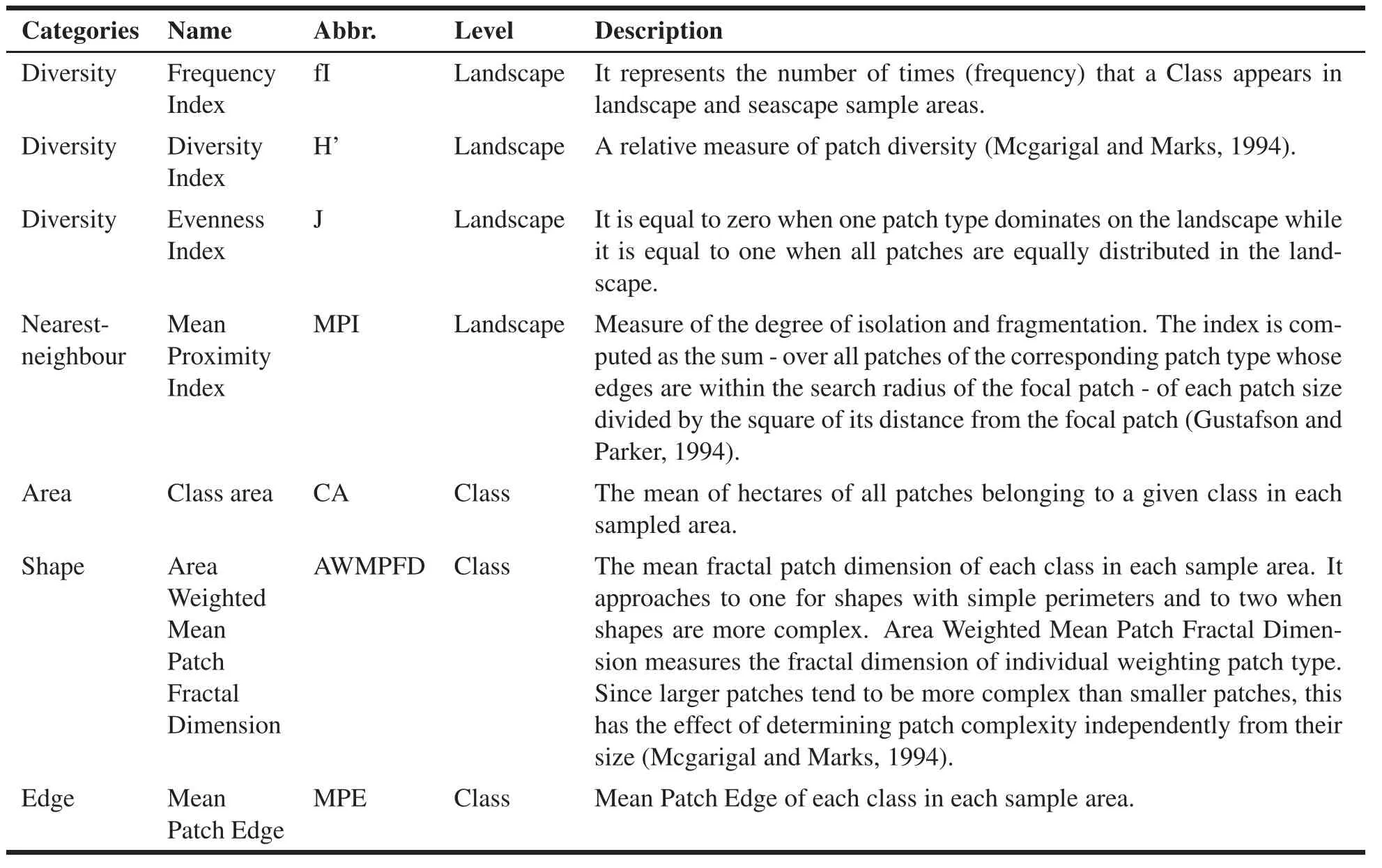
Table 1 List of 7 landscape metrics evaluated in this study.
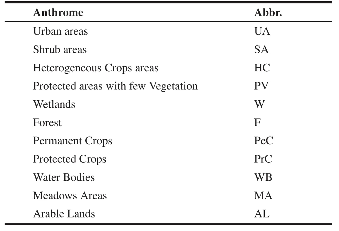
Table 2 List of natural and anthropogenic ecosystems composing landscape
3 Results
3.1 Landscape and seascape classes
From the classification already contained in the PTR,it is evident that the landscape of the Gulf of Naples is characterized by 11 natural and anthropogenic ecosystems to be considered representative of anthromes(Table 2).
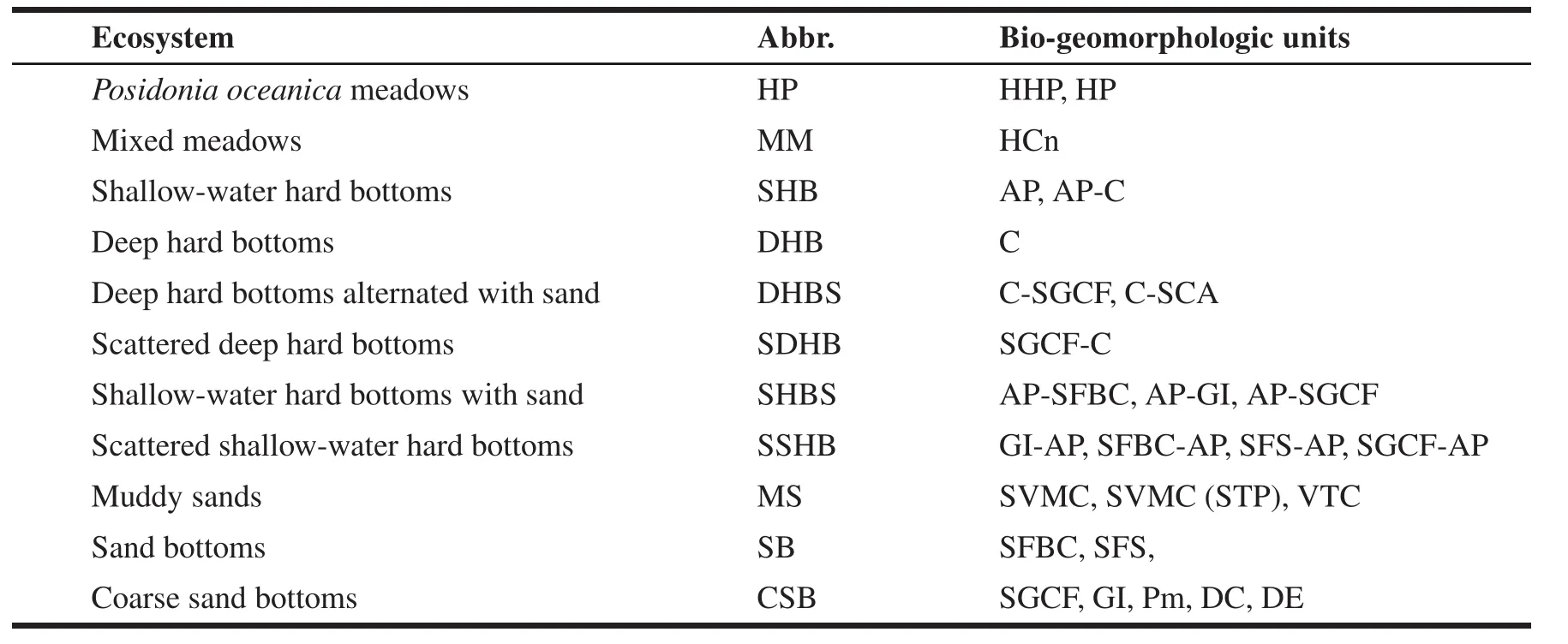
Table 3 Seascape bio-geomorphologicunits.
The 26 different ecosystems detected on seascape are grouped in 11 bio-geomorphologic units,on the base of sessile and sedentary organisms and sediment texture(Table 3).
3.2 Landscape and seascape metrics
Landscape resulted markedly dominated by human settlements and crops,while wild ecosystems were confined to the top of mountain and of volcanic areas(Vesuvio mount and Phlegrean Fields).
Seascape was manly constituted by muddy and coarse sand bottoms while areas dominated by vegetation and deep hard bottoms were confined around islands and close to the coast.
fI(frequency with which a particular class is detected in the samples areas)showed high values for UA and CSB being present in almost all sampling areas,indicating that those classes dominate landscape and seascape.Looking at landscape and seascape as a whole,classes composing landscape were more evenly distributed than classes composing seascape(Fig.6a).
Comparing compositional and structural indices characterizing landscape and seascape,diversity and evenness showed higher mean values and lower variability for landscape than seascape(H’landscape=1.26,H’seascape=0.49,J landscape=0.79,J seascape=0.55)(Fig.6b).However,landscape is composed by anthropogenic ecosystems,thus higher diversity and evenness indices were not positive since they measure fragmentation and anthropogenic manipulation degrees.
MPI metric showed higher mean values and lower variability on landscape than seascape.In particular,MPI values of classes that compose landscape covered 2 orders of magnitude,while MPI values of classes that compose seascape covered 3 orders of magnitude(Fig.6c).
CA metric showed higher mean values than UA on landscape and higher than CSB and DHBS on seascape.Lower values of W and WB in landscape and of MM and SSHB in seascape were also detected.Landscape also showed a lower variability than seascape;in particular,on seascape a very high variability among samples by CSB and MS was detected(Fig.6d).
The highest values and variability of AWMPFD metric,at landscape level,characterized SA and WB classes even if differences with other classes were not marked.In the seascape,high values characterized SHB and SDHB classes,while low values characterized CSB and MS classes.A high variability among all classes composing seascape was also detected(Fig.6e).
Sandy and muddy classes(HP,CSB,SB)were characterized in the seascape by comparable MPE values,even if HP and SB showed the highest variability;important values were also recorded for the MS class.In the landscape,the highest MPE values were shown by HC,PeC,and UA.Low values were detected for SA,AL,W,and WB,while F,MA,PrC,and PV showed intermediate values(Fig.6f).
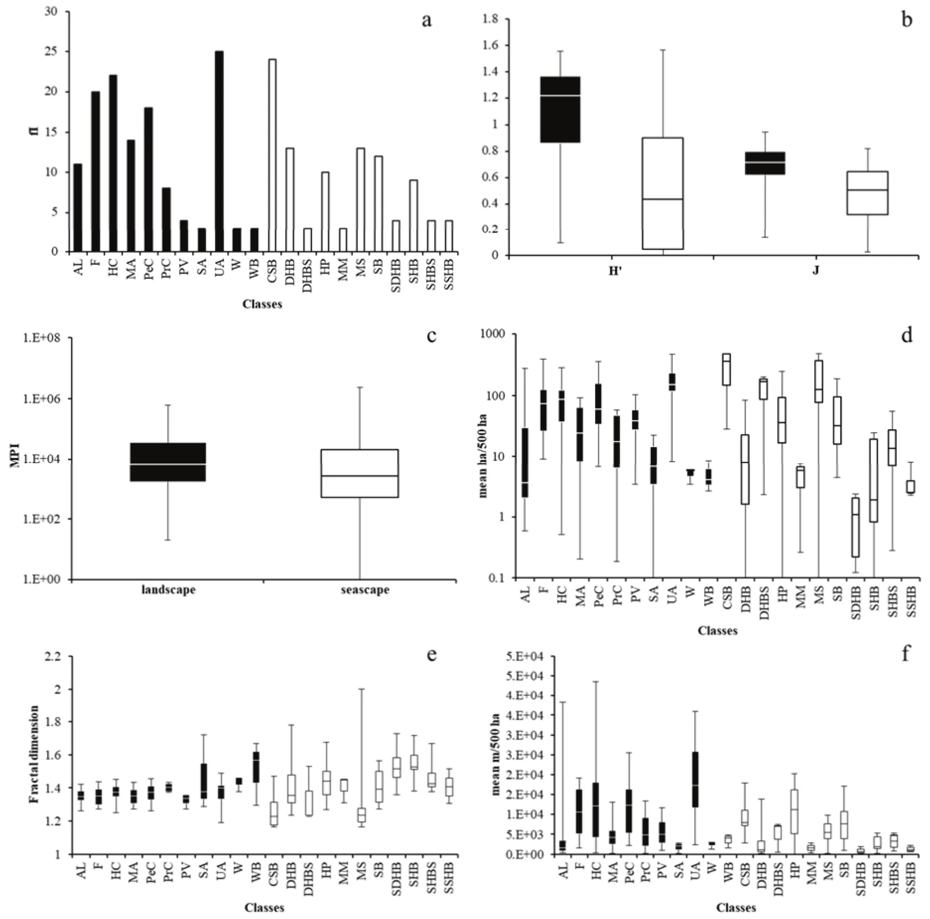
Fig.6 a)frequencyIndex(fI)showing number of times that a class occurs in all the 25 sampling areas in landscape(black bars)and in seascape(white bars);b)Diversity(H)and Evenness(J)indices of landscape(black boxes)and seascape(white boxes);c)Mean Proximity Index(MPI,logarithmic scale)calculated on classes of landscape(black boxes)and seascape(white boxes);d)Class area(CA,logarithmic scale)detected in the sampling areas on classes of landscape(black boxes)and seascape(white boxes);e)Area Weighted Mean Patch Fractal Dimension(AWMPFD)for each class detected in the sampling areas of landscape(black boxes)and seascape(white boxes);f)Mean Patch Edge(MPE)detected for each class in the sampling areas of landscape(black boxes)and seascape(white boxes)..
3.3 Multivariate analysis
PERMANOVA analysis performed on landscape metrics of the full dataset detected significant differences between landscape and seascape.In particular,metrics producing these differences are MPE,diversity,and evenness metrics(Table 4).
PERMDISP results also showed significant differences(p<0.01)in the distances from centroids of classes selected on factor “Type”for MPE,diversity,and evenness metrics.In particular,distances from centroids highlighted lower small-scale heterogeneity in landscape than in seascape(Fig.7).Such findings indicated thatecosystems composing landscape were more evenly distributed than those composing seascape.
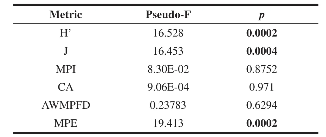
Table 4 Main results of the PERMANOVA tests for differences related to metrics of landscape and seascape in single response variables.Significant p-values are given in bold.
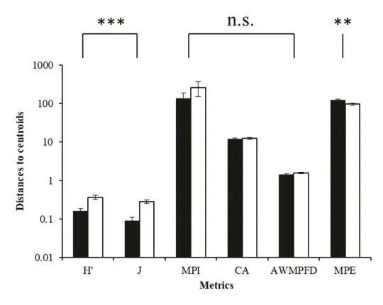
Fig.7 Mean(±SE)multivariate dispersion of replicates around Type centroids calculated on landscape metrics data for landscape(black bars)and seascape(white bars).Results of pair-wise tests are also reported.n.s.:not significant;**:p<0.01;***:p<0.001.
Thus,results highlighted that landscape patches patterns were homogeneously distributed in the whole Gulf of Naples.
4 Discussion
Landscape and seascape accounting was carried out by means of different techniques to estimate anthropogenic impacts in terms of ecosystems patches fragmentation.In particular,statistics applied to metrics of landscape ecology were employed to quantify the spatial distribution of ecosystems heterogeneity(γ-variability)related to ecosystem resilience in an integrated land-sea territorial system.
4.1 Landscape and seascape accounting
The applied metrics of landscape ecology show that landscape is more impacted by humans than seascape,even if both are subjected to heavy pressures and exploitation.In particular,compared to seascape,on landscape the more direct and easier human manipulation determines higher patch diversity and patch edge dimensions as well as an higher variability among sample areas randomly chosen,highlighting a functional connectivity profile rather than a structural one.However,although similar ecosystems patches could be used by organisms as stepping stones to move through the landscape(Reiners,2005),natural areas are surrounded by strongly anthropized zones and little is known about the effectiveness of links and corridors among similar patches,that should ensure species movements among them(Martin et al.,2012).
In contrast to functional connectivity,described by meta-ecosystems processes among patches,ensuring fluxes of materials and energy(Massol et al.,2011),the structural connectedness refers to the physical links between patches belonging to the same ecosystem,which facilitate animal dispersal(Jongman et al.,2004).In this study,structural connectedness mostly characterizes seascape through two important bio-geomorphological classes,MS and CSB,which are the most extended and widespread.Therefore,a more homogeneous physiognomy characterizes seascape,hampering the diffusion of species with scarce capacity of dispersion(With et al.,1999).
Interaction between shape and size of patches in fluences a number of important ecological processes.In particular,shape complexity of patches has been shown to in fluence inter-patch processes,such as animal migrations(Buechner,1989),plant colonization(Hardt and Forman,1989),and animal foraging strategies(Farina,2008).In addition,some researchers noted that the most fragile or vulnerable ecosystems patches are associated with the smaller fractal dimension(Krummel et al.,1987;Li,2000).This is the case of the studied landscape where anthropogenic activities affect the complexity index(AWMPFD metric)that resulted lower than in the seascape.
Compared to seascape,studied highly anthropized landscape is characterized by higher values of Mean Proximity Index which is,in turn,directly correlated with highβ-diversity(Hendrickx et al.,2007).This is also true for natural landscapes,but the investigated landscape is unsuitable to host wildlife.
4.2 γ-variability
Asin community ecology(Anderson et al.,2011),in this studyγ-variability was used to assess the heterogeneity degree of seascape and landscape.
Results show that seascape is characterized by higherγ-variability than landscape,thus landscape is more equally fragmented throughout the whole study area.
Results also confirm that high values of heterogeneity,and thus ofγ-variability as found in seascape,are representative of a low anthropogenic impact;in contrast,the more homogenous pattern of patches(lowγvariability)of the studied landscape is the consequence of anthropogenic modifications(Van Nes and Scheffer,2005).
Thus,our findings suggest that seascape components(meta-ecosystems)maintain functional patch variability,a feature of wild systems well self-organized to maximize their resilience.
4.3 Resilience
Results on landscape are typical of a fragmented area with low resilience(Uuemaa et al.,2013).Resilience theory has been largely focused on understanding how complex adaptive systems change and shape in their structure and function(Scheffer et al.,2001;Folke et al.,2004).For example,some studies have shown that resilience of landscapes is directly correlated with size and shape of ecosystems composing them(Holt,1992;Brühl et al.,2003)and with the homogenization of patches pattern(Pittman and Brown,2011;Siqueira et al.,2015).
The relationship between spatial properties at regional(e.g.,connectivity,mean patch size,amount of edge)and ecosystems patterns is non-linear;ecosystems erosion and spatial variation in their composition could introduce complex variation,particularly where landscape structure determines contagious processes as spread of disease(Boswell et al.,1998;King,1999;With and Crist,1995).Multivariate analyses are helpful to identify significant differences both among metrics and onγ-spatial variability.In the present investigation,landscape is composed by anthropogenic ecosystems with small and equally distributed patches.This produces significant differences compared to seascape mainly in patches edges and diversity.Indeed,landscape presents the characteristic of a homogenously fragmented environment where the presence of anthropogenic ecosystems hampers species movements and their long-term persistence,therefore determining a low resilience.On the contrary,seascape shows more heterogeneous patches fragmentation that enhances species movements and settlements,therefore determining a potential high resilience.
5 Conclusions
Landscape and seascape of the Gulf of Naples were studied as an integrated territorial system,using landscape metrics and statistical methodologies to account for human activities impacting and modifying terrestrial and marine territory.
Applied metrics highlighted the anthropogenic nature of landscape and the higher naturalness of seascape despite its strong exploitation.Landscape ecosystems were more evenly distributed among the whole study area compared to the seascape showing greater variability of ecosystem patches size and distribution.
The attempt at using multivariate techniques as PERMANOVA and PERMDISP for the first time in landscape ecology provided promising results.Both analytical techniques highlighted significant differences between landscape and seascape in terms ofγ-variability.
Finally,heterogeneity of patches distributions resulted helpful to account for anthropogenic modifications and to address management actions both in landscape and seascape.Indeed,more natural systems with higher resilience such as seascape can be treated as a system at the lower ecological rank(assemblages or population)being characterized by a great variability of ecosystems pattern distribution,measured byγ-variability.Conversely,anthropized landscape is characterized by more regular ecosystems distribution patterns,mainly due to the interposition of anthropogenic ecosystems among natural patches,which hampers material and energy flows among natural ecosystems.Therefore,such landscape needs more attention in evaluating patches structures in fluencingγ-variability.
These findings are also useful in support of environmental accounting and management at landscape scale,suggesting that anthropogenic impact in an integrated territorial system is inversely related toγ-variability,and consequently to resilience,and that seascape is more resilient than landscape also in highly exploited and overcrowded areas such as the gulf of Naples.
Acknowledgements
This work is part of Luca Appolloni Ph.D.thesis(2013-2015), financially supported by a scholarship of Italian Ministry of Education(MIUR)and by National Interuniversity Consortium of Marine Sciences(CoNISMa).
 Journal of Environmental Accounting and Management2018年4期
- Journal of Environmental Accounting and Management的其它文章
- Light Fertilization Affects Growth and Photosynthesis in Mung Bean(Vigna radiata)Plants
- Capture Rate of Selected Heavy Metals In Q.Ilex L.Leaves Collected At Two Sites With Different Land Uses
- Impact of Biochar Amendment on Soil Quality and Crop Yield in a Greenhouse Environment
- Regional Redistribution Effects of Renewable Energy Subsidies
- Phytotoxic Extracts as Possible Additive in Subsurface Irrigation Drip for Organic Agriculture
- Ecotoxicological Assessment of Virgin Plastic Pellet Leachates in Freshwater Matrices
