Spatial and temporal distribution of forest fire frequency and forest area burnt in Jilin Province,Northeast China
Qiang Liu•Yanlong Shan•Lifu Shu•Pingyan Sun•Shuai Du
Abstract Forest fires caused by natural forces or human activities are one of the major natural risks in Northeast China.The incidence and spatial distribution of these fires vary over time and across the forested areas in Jilin Province,Northeast China.In this study,the incidence and distribution of 6519 forest fires from 1969 to 2013 in the province were investigated.The results indicated that the spatiotemporal distribution of the burnt forest area and the fire frequency varied significantly by month,year,and region.Fire occurrence displayed notable temporal patterns in the years after forest fire prevention measures were strictly implemented by the provincial government.Generally,forest fires in Jilin occurred in months when stubble and straw were burned and human activities were intense during traditional Chinese festivals.Baishan city,Jilin city,and Yanbian were defined as fire-prone regions for their high fire frequency.Yanbian had the highest frequency,and the fires tended to be large with the highest burned area per fire.Yanbian should thus be listed as the key target area by the fire management agency in Jilin Province for better fire prevention.
Keywords Fire intensity·Forest fire·Temporal distribution·Spatial distribution
Introduction
Forests are a major natural resource and play an important role in maintaining environmental balance.The health of a forest in any given area is a true indicator of the ecological conditions prevailing in that area.Fire is one of the most severe agents that damage forest resources,which are periodically subjected to wild fires of different intensities.Furthermore, fire hazard has increased due to the augmentation of the population,rural exodus,and the human ignition sources(Sanmiguelayanz et al.2002).
Fires lead to permanent changes in the composition of vegetation community,cause a decrease in forest area and biodiversity,soil degradation,alteration of landscape patterns and ecosystem functioning,thus hastening desertification processes.Annual fires may decrease the growth of grasses,herbs and shrubs,which may also increase soil erosion(Kandya et al.1998).Obviously,forest fires are a potential hazard with physical,biological,ecological and environmental consequences.The increased fire activity throughout the world also increases the global greenhouse gas emission(such as CO2and CH4)(Werf et al.2004)and is a major source of CO and other air pollutants(Carvalho et al.2016;Crutzen et al.1985;Wei et al.1990).
The frequency of fires can be reduced by modifying fire management strategies.Quantification of fire regimes,by frequency,intensity,severity,season of burn,type,and spatial pattern(size,shape),can provide a general summary of the history of fire events over large areas and long time frames(Gill and Allan 2008)and inform policy decisions.For example,it has been suggested that pine forests and aspen forests burn more frequently than do spruce forests(Bergeron 1991;Cogbill 1985),and dry sites burn more frequently than moist sites(Clark 1990).Moreover,a previous study found that fire frequency has decreased since the late 1800s years due to climate change(Engelmark et al.1993).Spatial and temporal variability in the susceptibility of forests to fire are important aspects of fire regimes(Heyerdahl et al.2008,2002;Kitzberger et al.1997;Turner and Romme 1994;Ullah et al.2013).Despite the spatial and temporal variability is inherent in fire regimes,however,few studies adequately address these aspects because long-term data are difficult to obtain for large regions(Elia et al.2012;Larsen 2010;Niklasson and Granström 2008;Nunes et al.2016).
To minimize the threat from forest fires, fire managers must be able to plan protection strategies that are appropriate for individual,local areas.A prerequisite for this planning is the ability to assess the forest fire risk distribution.New data and nontraditional approaches are needed to study the spatial and temporal distribution of forest fires under natural and anthropogenic influences.In the present study,we analysed the variability in forest area burnt and fire frequency in different regions and at different times to evaluate fire danger and determine the spatiotemporal distributions of forest fires.
Materials and methods
Study area
Jilin Province in the central part of the northeastern China(Fig.1)bordering Russia and North Korea has a total area of 187,000 km2and a total population of 27.5 million.It has a northerly continental monsoon climate,with long,cold winters and short,warm summers.The average annual temperature is 5.1°C,and the average annual rainfall is 763.3 mm.Jilin Province is an important forestry base in China,with live timber volume amounting to 0.97 billion m3,ranking sixth in the country.Besides that,the Changbai Mountains area in this province is one of China’s six major forestry areas.It also has abundance of traditional Chinese medicine resources,with approximately 27,000 kinds of wild plants and 9000 kinds of medicinal herbs.Jilin is highest in altitude in the southeast and drops gently toward the northwest.The Changbai Mountains run through its southeastern regions and contains the highest peak of the province.Other ranges include the Jilinhada Mountains,Zhang Guangcai Mountains,and Longgang Mountains.The area is drained by the Yalu and Tumen rivers in the extreme southeast(which together form parts of the border between the People’s Republic of China and North Korea),by tributaries of the Liao River in the southwest,and by the Songhua and Nen rivers in the north,both eventually flowing into the Amur(Jilin Bureau of Statistics 2014).
Data set
The data used in this study were collected from Jilin Provincial Forest Fire Prevention Headquarters and Archives of Jilin Province,and the data included complete fire information such as fire occurrence time,occurrence location,area burned and so forth in Jilin province.During the 45-year study period,6519 forest fires occurred in the study area in the following regions:Changchun city,Jilin city,Songyuan city,Siping city,Tonghua city,Baishan city,Baicheng city,Liaoyuan city,Yanbian Korean Autonomous Prefecture(Yanbian for short)and Changbai Mountain Nature Reserve(Changbai for short).
Statistical analyses
The software of SPSS 16.0(SPSS,Chicago,IL,USA)was used for all statistical analyses.The GIS package in Arc-Map 10 was used for the spatial analyses;the spatial distribution maps were created using the Kriging interpolation method.To assess the forest fire severities and to estimate their possible impact to the forest ecosystem,we calculated the sizes of the fires.Based on the ‘‘Regulations on Forest Fire Prevention(2008 revision)’’,which was formulated by General Office of the State Council of the People’s Republic of China in 1988,the forest fires could then be divided into four classes:C1,general forest fire,forest area burnt is<1 ha;C2,large forest fire,forest area burnt is≥1 and<100 ha;C3,major forest fire,forest area burnt is≥100 and<1000 ha;C4,especially large forest fire,forest area burnt is≥1000 ha.
Results and discussion
Temporal distribution of forest fires
Fire events are generally summarized in terms of size,burn duration and fire sites,which are descriptors of forest fireactivity.Forest fires occurred in typical temporal patterns after the implementation of management measures and better control of human activities(Stocks and Martell 2016),with temporal spans varying from months to years,with marked variations introduced when fire causes are taken into account.Over the past decades,the trend in forest fire frequency and area burned in Jilin Province first increased and then decreased,with an important turning point in 1979(Fig.2),one of the worst years of forest fire disasters with 848 forest fires,the most in 1 year during the past four decades.But since 1979,the forest fire frequency in the study area has significantly declined,and tended to stabilize from 1984,mainly because a forest law of the People’s Republic of China(Trial)was constituted in 1979 for the first time and officially established in 1984.Clearly,strict implementation of prevention measures can play a decisive role in controlling fire occurrence.Generally,anthropogenic fires are more evenly spread throughout the year(Vazquez and Moreno 1998),with the highest fire occurrence always during drought in the summer season(Hessl et al.2004).But forest fires are always concentrated in a few months due to specific human activities.In countries that still practice agricultural fires,the temporal distribution of fires is clearly linked to this practice.Two peaks of fire occurrence in the spring and summer have been found in some countries(Tucěk and Majlingová2009),and both are mainly linked to farmers burning stubble.At present,although it is strictly prohibited,stubble and straw burning is still widespread in China,mainly because that the recycling system of crops straw is still imperfect.Because Jilin Province is the most important grain production base in China,it faces a great challenge in handling the resultant straw,so straw burning is very common phenomenon.In Jilin Province,the first forest fire peak is in early spring(April and May)and a second peak in autumn(September and October)(Fig.3),
which correspond to stages of farming:spring plowing and autumn harvest.Therefore,it is extremely urgent for China to find effective measures for treating the crop straw in order to control the occurrence of forest fires.Many other human activities such as spring outings,wild vegetable harvest,ancestor worship and travel in the study area,also contribute to the fire risk.The Qingming Festival is one of the most important traditional festivals in China in April,when paper and incense burning for ancestor worship at graveyards(usually on hills)can significantly increase fire danger.Forest fires are also more likely to occur in International Labor Day(May 1),Mid-Autumn Festival(in the middle of September),and National Day(October 1)with the high volume of tourists.
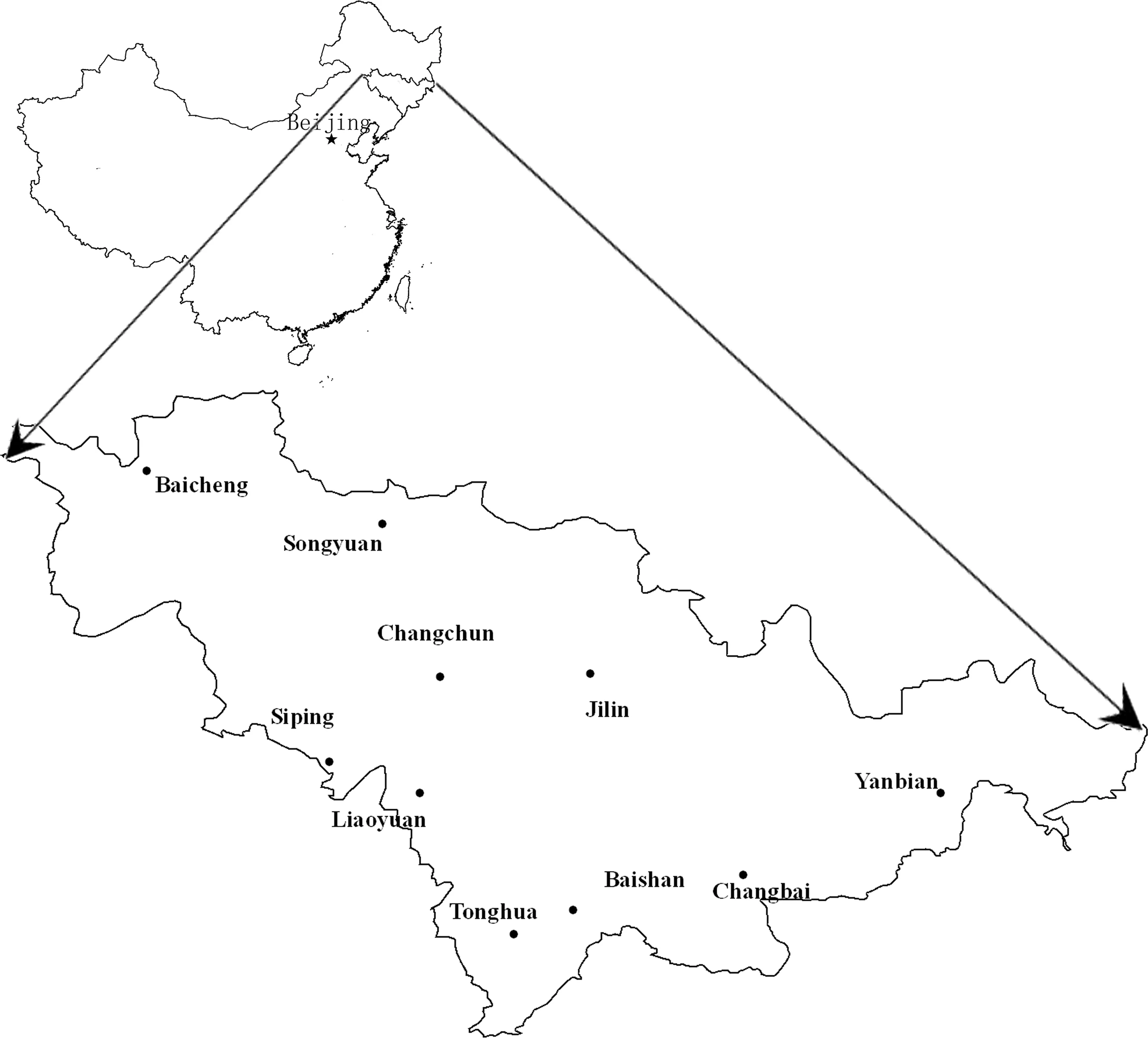
Fig.1 Map of the study area and location in China
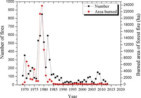
Fig.2 Number of forest fires and area burned during 45 years in Jilin Province
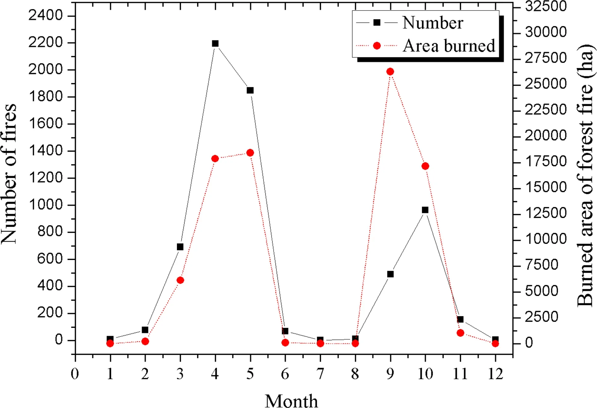
Fig.3 Number of forest fires and area burned by month during the period 1969 to 2013 in Jilin Province
Spatial distribution of forest fires
Spatial distribution of forest fire occurrence varied from place to place owing to differences in incidence and size offires as influenced by many factors.Several studies have emphasized the crucial role of human activity in the spatial distribution of wild fire ignitions(Cardille et al.2008;Martínez et al.2009;Padilla and Vegagarcía 2011;Prestemon and Butry 2005;Romero-Calcerrada et al.2008;Russellsmith et al.1997).Weather is also one of the most important determinants of fire occurrence and behavior and is a significant short-term factor influencing fire distribution(Hunter 1993;Malamud et al.2005;Minnich and Chou 1997).In the present study,the forest area burnt and fire frequency varied significantly among different regions in Jilin Province(Figs.4,5)with the number in decreasing order:Yanbian>Baishan city>Jilin city>Tonghua city>Changchun city>Siping city>Liaoyuan city>-Baicheng city>Songyuan city>Changbai.Thus,Baishan,Jilin and Yanbian can be defined as fire-prone regions compared with other regions.In Yanbian area,2672 forest fire accidents from 1969 to 2013 burned a total forest area up to 6896 ha.Yanbian is part of the national forestry base in China with a population of about 2.15 million.Its forest area is 3.472 million hectares,forest coverage is 78.2%,and the total reserves are 332 million m3(Yanbian Bureau of Statistics 2014).The special natural conditions and frequent human activities significantly increase the likelihood of forest fire disasters in Yanbian.So the high forest cover and population are the important causal factors of forest fires.In addition,the topographic features of Yanbian,low in the center and surrounded by mountains,provide basin and foehn effects that easily create the high temperature and low humidity that are favour forest fires.
Assessment of forest fire size classes
An awareness of the amount of damage due to forest fires of different size classes can also help in managing prevention and suppression resources among the classes.The assessment results of forest fire severities in Jilin Province are presented in Table 1.The frequency of forest fires in the various size classes from highest to lowest was:C1>C2>C3>C4.Although only 1.96%of the fires were classified as a major forest fire,the total area burned was significantly higher than after a large forest fire.Therefore,timely and effective fire suppression as well as controlling the sources of ignition were crucial in protecting forest ecosystem.Suppression should be started as early as possible,when fires are small,so they can be completely extinguished.The mapping result showed that C3 and C4 fires mainly occurred in Yanbian(Figs.4,5),indicating that the area was more susceptible to forest fires than other regions in Jilin.The central part of Jilin has been less affected by forest fires than the eastern regions;the western part of Jilin has the least forest fire danger.Based on our study,the Yanbian Korean Autonomous Prefecture has the highest fire danger in the province,and Yanbian should be treated as the key protection area for better fire prevention in Jilin.
Conclusions
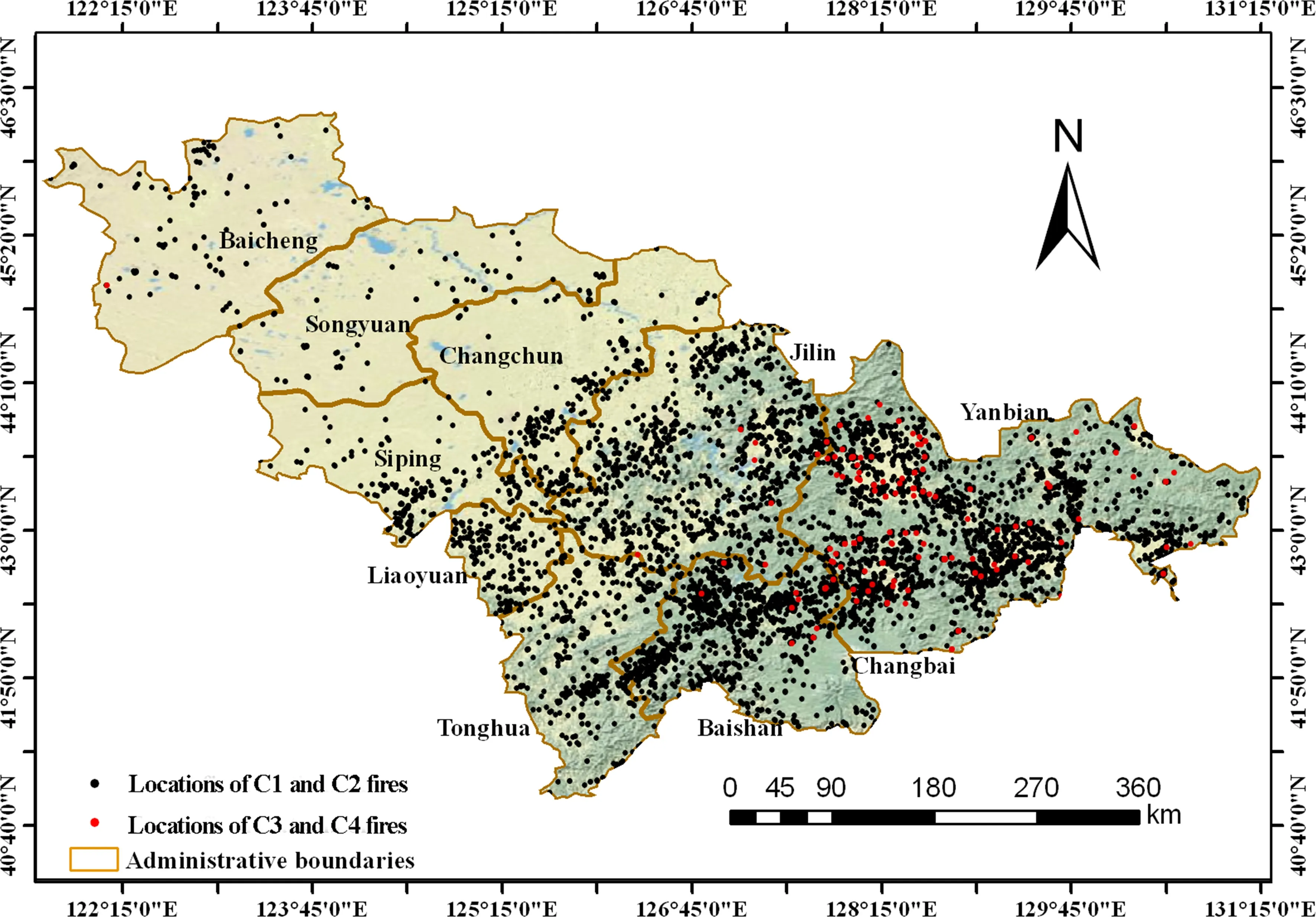
Fig.4 Spatial distribution of forest fires in the different size clasess in Jilin Province
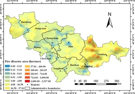
Fig.5 Spatial distribution of area burned by forest fires in Jilin Province

Table 1 Characteristics of forest fire classes
Knowledge about the spatiotemporal distribution of forest fires and sources of ignition is crucial for devising suitable preventive policies in each region of the province,by considering socioeconomic,cultural,and environmental conditions in each region.In this study,the spatiotemporal distribution of fire occurrence in Jilin,one of the most important forestry bases in China,were studied.Forest fire occurrence displayed different temporal patterns after 1984 after strict implementation of management measures and human-activity controls in forests.In Jilin, fire occurrences were concentrated in a few months mainly from stubble and straw burning that is widely practiced in the study areas and peaked in early spring( first peak:April and May)and in autumn(second peak:September and October),corresponding to spring plowing and autumn harvesting,respectively.To prevent fires,effective measures in Jilin should solve the problem of burning agricultural crop straw.Also,special measures are needed to control human activities in forested areas during holidays and festivals to lower the ignition danger.Area burned and fire frequency vary largely among different regions in the province.Yanbian,which is highly prone to fires and had the highest fire frequency from 1969 to 2013,should be the top priority for fire prevention in Jilin.
 Journal of Forestry Research2018年5期
- Journal of Forestry Research的其它文章
- Environmental load of solid wood floor production from larch grown at different planting densities based on a life cycle assessment
- An overview of proven Climate Change Vulnerability Assessment tools for forests and forest-dependent communities across the globe:a literature analysis
- Assessing the vulnerability of a forest ecosystem to climate change and variability in the western Mediterranean sub-region of Turkey:future evaluation
- Effects of management regimes on carbon sequestration under the Natural Forest Protection Program in northeast China
- Mixed-effects modeling for tree height prediction models of Oriental beech in the Hyrcanian forests
- Estimation of a basal area growth model for individual trees in uneven-aged Caspian mixed species forests
