盐构造与深水水道的交互作用
——以下刚果盆地为例
陈亮,赵千慧,王英民,孙红军,万琼华,唐武,赵鹏
1.中海油研究总院,北京 100028 2.中国石油管道局工程有限公司国际事业部,河北廊坊 065000 3.浙江大学海洋学院,杭州 310058 4.中国石油化工股份有限公司石油勘探开发研究院,北京 100083 5.中海石油( 中国) 有限公司深圳分公司,广州 510240
盐构造与深水水道的交互作用
——以下刚果盆地为例
陈亮1,赵千慧2,王英民3,孙红军4,万琼华5,唐武1,赵鹏5
1.中海油研究总院,北京 100028 2.中国石油管道局工程有限公司国际事业部,河北廊坊 065000 3.浙江大学海洋学院,杭州 310058 4.中国石油化工股份有限公司石油勘探开发研究院,北京 100083 5.中海石油( 中国) 有限公司深圳分公司,广州 510240
在被动大陆边缘盆地,水道作为深水油气的主要储集体,是深水油气勘探的重要目标。在下刚果盆地,由于盐构造的多期活动导致对水道砂体的展布规律认识不清。研究水道和盐构造的交互作用方式有利于预测含盐盆地中水道砂体的平面分布。利用三维地震资料,在盐构造与深水水道广泛发育的下刚果盆地研究盐构造与深水水道的交互作用,建立了盐构造与水道的交互作用模式。盐构造与水道的交互作用方式主要有6种,分别为限制、改向、封堵、侵蚀、迁移和剥蚀。盐构造的活动时期与水道形成演化时期的先后关系、水道中重力流的侵蚀能力决定了盐构造与水道的交互作用方式。水道经过早期发育的盐构造且水道中重力流侵蚀能力较弱多发生限制和改向;若水道中重力流侵蚀能力很强,可发生水道对盐构造的侵蚀;若盐构造的规模较大,其可阻止水道向下游输送沉积物并造成水道中重力流的回流,形成朵体沉积。若水道与盐构造同时活动多发生水道的迁移。晚期活动的盐构造可导致其上方的水道沉积体遭受剥蚀。
盐构造;深水水道;迁移;交互作用;下刚果盆地
0 引言
由于与深水储层密切相关,深水水道及相关的沉积体受到了学术界与工业界的广泛重视[1-4]。深水沉积过程及其产物已成为世界沉积学界研究的热点[5-7]。深水沉积中,对于水道沉积过程的研究有助于理解和推断砂体的展布规律[8-10]。在深海陆坡体系里,深水水道穿过复杂的陆坡地表时常表现为复杂的地貌特征。由于断块的掀斜、盐、泥底辟的发育,当深水水道通过这些障碍物时,将绕开这些障碍物[11-21]。与不受陆坡地形控制的深水水道相比,受陆坡地形控制的水道在内部构型以及平面展布上均表现出明显的不同[21]。另外部分学者使用陆坡均衡剖面的概念对深水水道开展研究[22-23],构造运动使得陆坡均衡剖面发生改变,从而导致水道在弯曲度、宽深比以及侵蚀加积比上均表现出相应的特征。
本文主要研究盐构造与深水沉积的交互作用。盐构造,是指在重力/浮力和区域应力等综合作用下,盐岩、泥岩以及其他密度低于上覆层的物质流动形变所形成的地质变形体[24]。国内学者对盐构造开展了广泛的研究,多为盐构造的成因分析、运动学特征、构造样式、以及盐构造对于油藏的控制[25-27],但关于盐构造与深水水道的交互作用方面的研究鲜有报道,国外学者的研究主要为盐构造对深水水道的控制[11,19],并未对水道对盐构造的改造进行讨论。以三维地震资料解释、处理和分析为基础,研究盐构造与深水水道的交互作用,建立盐构造与深水水道的交互作用模式,旨在为盐构造广泛发育区的深水砂体预测提供指导。
1 区域地质概况
研究区位于西非被动大陆边缘下刚果盆地(图1)。下刚果盆地是西非被动陆缘一系列微盆地中的一个,这些微盆地均由于早白垩世冈瓦纳大陆的分离所形成[28-29]。盆地的演化主要经历了裂谷阶段(晚侏罗世—早白垩世Aptian期)、过渡阶段(Aptian期)和被动大陆边缘阶段(晚白垩世—现今)[27-28]。非洲板块与南美板块分离开来,裂陷盆地开始发育,裂陷阶段在早Aptian期停止,陆相裂陷盆地逐渐向海洋环境过渡。随着海水的第一次入侵,由南向北的海水越过鲸鱼海岭,在限制性热带环境下,形成了晚Aptian期Loeme层蒸发盐沉积。Albian期,浅海的陆架上发育碳酸盐岩以及滨岸砂沉积,此时海洋环境继续扩张,在晚白垩世,热沉降作用开始加速,西非被动陆缘由边缘海向开阔海转变,逐渐进入深海环境,发育深海原地沉积和深水重力流沉积。

图1 研究区位置及地层柱状图[28]Fig.1 Location map showing the study area and stratigraphic column of the Lower Congo Basin[28]
由于盐岩的屈服强度可以忽略不计,盐岩在差异沉积负载下极易发生变形,在含盐盆地中,盐岩往往发生多期活动,含盐盆地的构造演化历史比非含盐盆地往往要复杂的多[30]。在下刚果盆地,前人对盐构造活动期次进行了系统分析,分析表明盐构造经历了三个时期和两个序列的演化,三个时期分别是早Albian期活跃期、晚Albian期—始新世稳定期和渐新世—现今再活跃期;盐构造样式经历了盐筏构造—继承性盐筏构造、盐筏构造—调节构造—垒堑构造的两个序列的演化[31]。本文研究的地层为中新世地层(图1),此阶段以深水重力流沉积体系为主,且处于盐构造的活跃时期,有利于开展盐构造与深水水道交互作用的研究。
2 盐构造与深水水道的交互作用方式
一般认为,深水水道是由重力流流动形成的,具有伸长的负向地貌特征,为输送陆源碎屑沉积物到深海盆地的重要通道。水道形态和位置受沉积过程或侵蚀下切作用的控制,水道地貌可以是侵蚀或沉积成因,也可以是两者兼而有之的复合[32]。本文立足于研究盐构造与深水水道的交互作用,难点为确定盐构造活动时期和水道发育时期的先后关系,进而分析在不同的构造背景下,深水水道与盐构造的交互作用方式。本文通过盐底辟两翼的上超反射特征及地层厚度的横向变化来分析盐构造的活动时期,从缺失的地层来判断水道的形成演化时期[11]。
盐构造与深水水道的活动时期按其发育的先后关系可分为3类,一是在水道形成之前,盐构造已经开始活动,形成正向的地貌单元;二为水道的形成过程中盐构造持续活动;三是水道形成之后盐构造开始活动,盐岩的上拱可能导致水道沉积体遭受剥蚀。国外以往的研究主要集中在早期活动的盐构造或褶皱对水道的影响[21],而忽略了同沉积构造以及后期盐构造对于水道的控制。盐构造与水道发育时期的先后、水道中重力流侵蚀能力的强弱共同控制了深水水道与盐构造的交互作用方式。本次研究认为,盐构造与水道的交互作用方式可分为6类,包括限制、改向、封堵、侵蚀、迁移和剥蚀。
2.1 限制
限制为早期发育的盐构造对水道及堤岸展布的控制作用,盐构造与水道的展布方向大致平行或低角度斜交,水道常常发育在盐构造的侧翼。由于盐构造的限制,导致水道无法侧向迁移从而不能形成高弯度水道,同时堤岸的展布范围亦受到盐构造的严格控制。
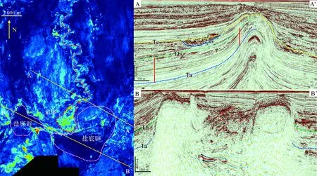
限制可分为两侧限制和单侧限制,两侧限制为水道的两端均发育早期的盐构造,其对水道的平面展布进行限制,而单侧限制为水道的一端发育有早期的盐构造。在研究区,单侧限制更为普遍。如图2所示,由Ta和Tb间的厚度向盐构造的轴部逐渐减薄,并可见清晰的上超反射,表明至少此时期,盐构造已经开始活动。在盐构造附近,受物源控制,水道自东北向西南展布,当水道堤岸复合体经过盐构造翼部时,靠近盐构造的一侧,堤岸展布明显受到盐构造的限制。若盐构造不再活动,水道持续加积,导致水道沉积填满可容纳空间,盐构造的限制能力减弱。此过程类似于墨西哥湾的微盆地充填溢出模式[33-34]。由于盐构造的限制,水道不再侧向迁移,弯曲度明显降低,不发育点坝沉积。需要强调的是,限制作用多发生于早期盐构造对深水水道的控制,即在水道发育之前,盐构造已经开始活动,并在陆坡上形成了正向的地貌单元。

图2 盐构造对深水水道的单向限制(RMS属性为地震剖面上沿Tc地层所提沿层属性,时窗为10 ms)Fig.2 Unidirectional confinement of salt structure to submarine channel(Time window used for RMS amplitude extraction: 10 ms alone the horizon marked with Tc )
2.2 改向
水道经过早期发育的盐构造时会绕开盐构造,继续向深海输送沉积物,此过程导致水道的展布方向在盐构造附近发生突变,本文将此现象称为深水水道的改向。
如图3所示,地震剖面上,Ta和Tb间的地层厚度在靠近盐构造的顶部明显变薄,表明此套地层为同沉积地层,盐构造在此时已经开始活动,而水道的形成时期在Tb之后,表明盐构造的活动时期在水道形成之前。该区域水道自北向南展布,水道经过盐构造附近区域时,其展布方向发生近90°的改变。在平面上,远离盐构造的区域,水道的侧向迁移明显,弯曲度较大,宽深比较大,而在盐构造附近,受盐构造的控制,水道的侧向迁移不再发育,弯曲度明显降低,宽深比减小,水道内部以垂向加积为主,推测水道内部砂体厚度变大。水道发生改向需要满足两个条件,其一盐构造的活动时期早于水道的发育时期;其二水道中重力流的侵蚀能力较弱,不能强烈侵蚀盐构造的顶部或翼部,因而水道只能绕开盐构造。
2.3 封堵
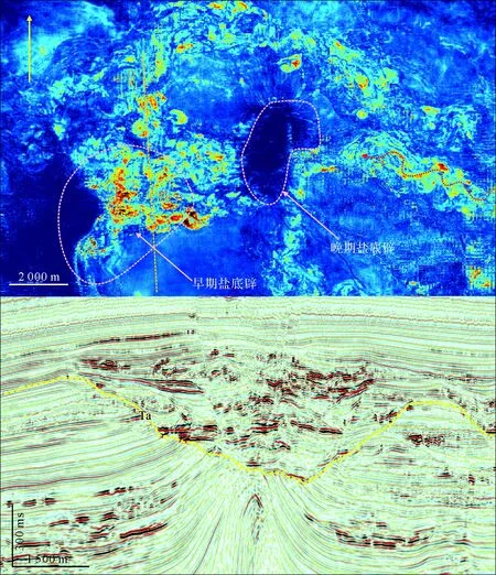
封堵指早期形成的、较大规模的盐构造如盐墙与水道的展布方向垂直或者大角度斜交,阻隔了水道中重力流的传输路径,造成重力流的回流,本文将此现象称为盐构造对水道的封堵。盐构造的封堵造成水道中重力流的回流减速,故盐构造的翼部可容纳空间内极易发育朵体沉积。
如图4所示,水道的发育时期在Tb之后,Ta与Tb间的厚度向着盐构造的顶部持续减薄,盐构造的翼部可见上超反射特征,表明盐构造的活动时期早于水道的形成演化时期。该区域水道自北向南展布,盐墙的走向近似与水道的展布方向垂直,当水道靠近盐墙时,重力流速度减缓,在盐墙的翼部,发育朵体沉积,朵体面积达3.2 km2。在盐墙内部常常发育构造低部位,本文将盐墙间的构造低部位称为盐墙的出口(见图4,剖面BB’)。朵体中的部分重力流可从盐墙的出口中穿过,向下继续输送沉积物。
2.4 侵蚀
当水道中重力流的侵蚀能力很强,且水道的展布方向与盐构造的走向正交,水道可切过盐构造的顶部,本文把此类现象称为侵蚀。
如图5所示,水道复合体自东向西展布,其发育在正在活动的盐构造之上。该水道复合体规模较大,内部重力流侵蚀能力很强,在经过早期盐构造时不必改向,直接切过盐构造的顶部,造成盐顶的侵蚀。需要强调的是,侵蚀发育的条件为盐构造的活动时期早于水道的发育时期,在水道经过时盐构造已经在陆坡形成正向的地貌单元;其二,水道中重力流的侵蚀能力非常强。侵蚀导致大型水道复合体位于盐构造上方,可形成砂体与盐顶叠置良好的构造圈闭。

图3 盐构造造成水道的改向(RMS属性为地震剖面上沿Tc地层所提沿层属性,时窗为10 ms)Fig.3 Channel diversion due to salt structure(Time window used for RMS amplitude extraction:10 ms alone the horizon marked with Tc)

图4 盐墙对于水道的封堵(RMS属性为地震剖面上沿Tc地层所提沿层属性,时窗为10 ms)Fig.4 Blocking of salt wall to channel(time window used for RMS amplitude extraction: 10 ms alone the horizon marked with Tc)
2.5 迁移
由于盐构造的持续活动,水道轴部逐渐向远离盐构造的方向迁移。迁移与改向不同,改向指单一水道经过早期发育的、活动微弱的盐构造时,绕过障碍物,方向发生突变;而迁移指的是盐构造在水道经过时持续活动且活动速率较高,水道的展布方向与盐构造的长轴方向近于平行,水道无法绕开盐构造,持续隆升的盐构造导致水道分叉、侧向迁移,单一水道演化成多个水道。
如图6所示,水道的发育时间在Ta之后,Tb之前,Ta与Tb间的厚度向着盐构造的顶部持续减薄,表明在水道形成期间盐构造持续活动。该水道自西北向西南展布,由于盐构造的活动速率强于水道中重力流的侵蚀能力,水道持续向远离盐顶的方向迁移,先后发育了两期水道,在平面上可见水道的分叉。水道在邻近盐顶的一侧侧向加积,而在远离盐顶的一侧发生侵蚀[35]。迁移导致了一期水道的废弃,二期水道广泛发育侧生加大边。在地震剖面上,一期水道呈弱振幅、低频反射特征,推测内部以泥岩沉积为主,夹薄层砂岩,类似于曲流河改道所形成的牛轭湖沉积。与一期水道不同,二期水道呈强振幅、中频反射特征,推测内部以砂岩沉积为主。

图5 水道对于盐构造的侵蚀(RMS属性为地震剖面上沿Ta地层所提沿层属性,时窗为10 ms)Fig.5 Corrosion of channel to salt structure(Time window used for RMS amplitude extraction : 10 ms alone the horizon marked with Ta)
2.6 剥蚀
晚期盐构造的活动可使位于其上方的早期水道沉积体露出地表,遭受剥蚀(图7)。若盐构造的活动速率较小,早期的水道沉积体未能露出地表遭受剥蚀,水道沉积体位于盐构造上方,可形成砂体与盐顶叠置良好的构造圈闭。
3 盐构造与深水水道的交互作用模式
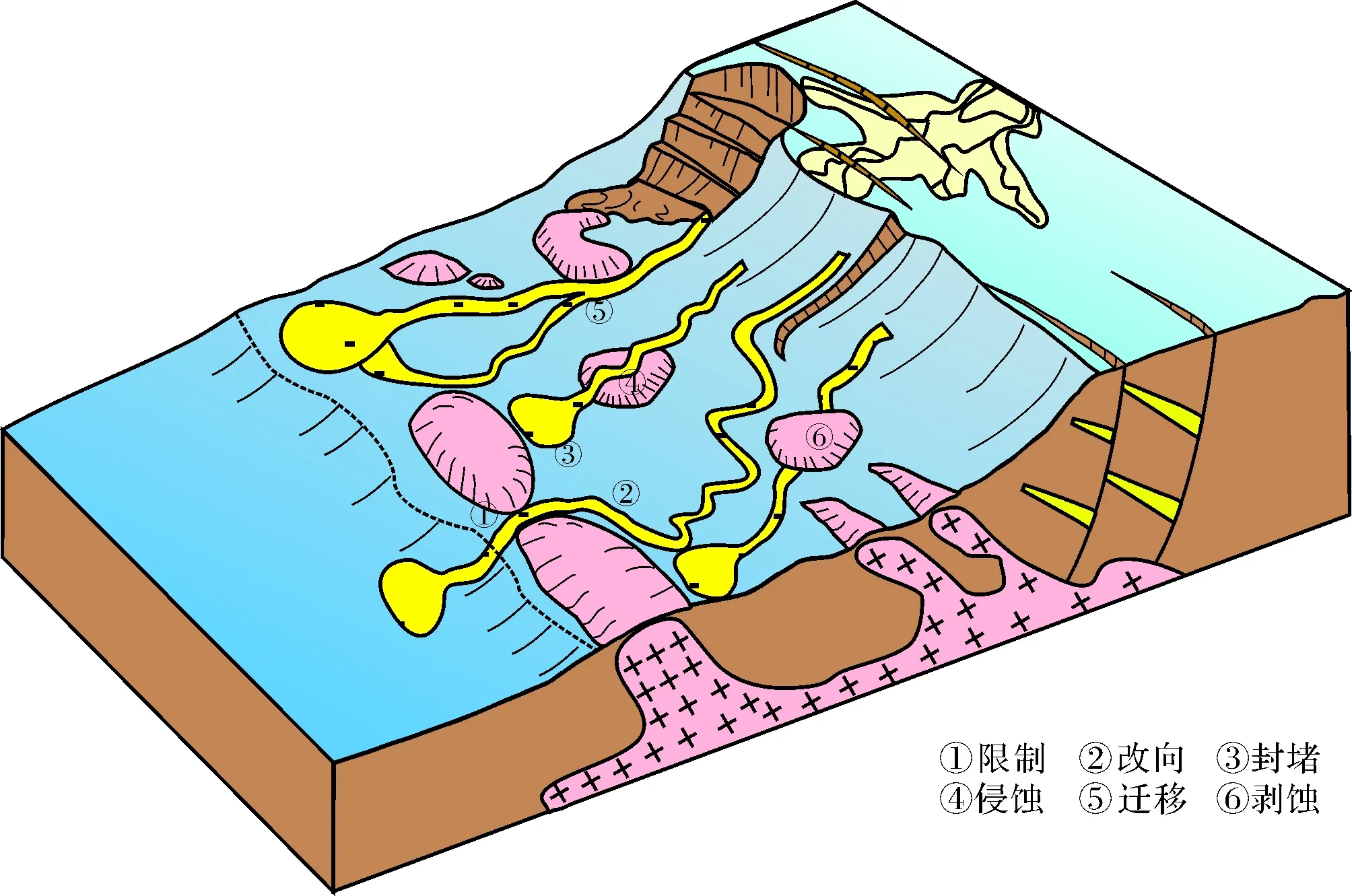
水道与盐构造的交互作用方式与多种因素有关,包括盐构造的活动时期与水道发育时期的先后关系、水道中重力流侵蚀能力的强弱。为建立盐构造与深水水道的交互作用模式,首先应确定盐构造的活动时期和深水水道形成时期的先后,这是控制水道与盐构造交互作用方式的主要因素。本文归纳为3类情况:1)盐构造的活动时期在水道发育之前,若水道中重力流侵蚀能力较弱,此种情况多发育限制(图8①)、改向(图8②)和封堵(图8③);若水道中重力流侵蚀能力非常强,水道对盐构造进行侵蚀(图8④)。2)盐构造的活动时期与水道的发育时期同步,此种背景下多发生水道的迁移(图8⑤)。3)盐构造的活动时期晚于水道的发育时期,盐底辟的上拱导致水道被托起,位于盐顶的水道沉积体可能被后期剥蚀(图8⑥)。

图6 盐构造与水道同时活动,造成水道的迁移(RMS属性为地震剖面上沿Tb所提沿层属性,时窗为10 ms)Fig.6 Salt structure resulting in channel deflection(Time window used for RMS amplitude extraction:10 ms alone the horizon marked with Tb)

图7 盐构造对水道的剥蚀(RMS属性为地震剖面上沿Ta地层所提沿层属性,时窗为10 ms)Fig.7 Erosion of salt structure to channel(Time window used for RMS amplitude extraction : 10 ms alone the horizon marked with Ta)
综上,建立了研究区盐构造与深水水道交互作用模式(图8)。
4 盐构造与深水水道的交互作用的地质意义
盐构造与深水水道的交互作用方式具有重要的地质意义,总结如下(表1)。

图8 盐构造对于水道的交互作用模式图Fig.8 Interaction models of salt structures and channels

交互作用方式地质意义限制水道堤岸沉积的厚度和展布面积受盐侧翼可容纳空间的控制,早期盐构造限制了水道的侧向迁移,不发育点坝沉积,砂体分布范围较为局限。改向改向导致水道砂体在盐构造附近展布方向发生突变,在盐构造附近,水道弯曲度降低,宽深比减小,水道内部的沉积地层厚度明显增大。封堵封堵造成水道中重力流的减速回流,盐墙的翼部极易发育朵体沉积。朵体作为深水油气的良好储集体,是深水油气勘探的重点目标。侵蚀侵蚀即水道复合体对盐顶造成侵蚀,由于水道复合体位于盐构造的顶部,可配合盐顶的构造高部位形成良好的构造圈闭。迁移导致水道轴部朝着远离盐顶的方向迁移,多伴生着水道的分叉,一期水道演化为多期水道。早期水道类似于牛轭湖沉积,砂体多不发育,晚期水道内砂体发育,是深水油气的有利储集体。
5 结论
(1) 在盐构造广泛发育的被动大陆边缘,水道和盐构造的交互作用方式主要有6种,分别为限制、改向、迁移、封堵、侵蚀和剥蚀。
(2) 盐构造的活动时期与水道发育时期的先后关系、水道中重力流侵蚀能力的强弱决定了盐构造与水道的交互作用方式。盐构造的活动时期在水道发育之前,若水道中重力流侵蚀能力较弱,多发育限制、改向和封堵;若水道中重力流侵蚀能力极强,多发育水道对盐构造的侵蚀;盐构造的活动时期与水道的发育时期同步,多发生水道的迁移;盐构造的活动时期晚于水道的发育时期,盐顶的水道沉积体可能被后期剥蚀。
(3) 盐构造与深水水道的交互作用方式具有重要的地质意义。限制导致水道不能侧向迁移,水道内部不发育点坝沉积;改向导致水道砂体的展布方向发生突变,在盐构造附近,水道弯曲度降低,宽深比减小;迁移多伴生着水道的分叉,砂体主要在晚期水道内发育;封堵造成水道中重力流的减速回流,盐墙翼部极易发育朵体沉积,可作为优质深水储集体。
)
[1] Deptuck M E, Steffens G S, Barton M, et al. Architecture and evolution of upper fan channel-belts on the Niger Delta slope and in the Arabian Sea[J]. Marine and Petroleum Geology, 2003, 20(6/7/8): 649-676.
[2] Gong C L, Wang Y M, Zhu Weilin, et al. The central Submarine Canyon in the Qiongdongnan Basin, northwestern South China Sea: architecture, sequence stratigraphy, and depositional processes[J]. Marine and Petroleum Geology, 2011, 28(9): 1690-1702.
[3] Kolla V, Bourges P, Urruty J M, et al. Evolution of deep-water Tertiary sinuous channels offshore Angola (west Africa) and implications for reservoir architecture[J]. AAPG Bulletin, 2001, 85(8): 1373-1405.
[4] Posamentier H W, Kolla V. Seismic geomorphology and stratigraphy of depositional elements in deep-water settings[J]. Journal of Sedimentary Research, 2003, 73(3): 367-388.
[5] Nakajima T, Peakall J, McCaffrey W D, et al. Outer-bank bars: a new intra-channel architectural element within sinuous submarine slope channels[J]. Journal of Sedimentary Research, 2009, 79(12): 872-886.
[6] Cross N E, Cunningham A, Cook R J, et al. Three-dimensional seismic geomorphology of a deep-water slope-channel system: the Sequoia field, offshore west Nile Delta, Egypt[J]. AAPG Bulletin, 2009, 93(8): 1063-1086.
[7] Wynn R B, Cronin B T, Peakall J. Sinuous deep-water channels: genesis, geometry and architecture[J]. Marine and Petroleum Geology, 2007, 24(6/7/8/9): 341-387.
[8] Pirmez C, Imran J. Reconstruction of turbidity currents in Amazon Channel[J]. Marine and Petroleum Geology, 2003, 20(6/7/8): 823-849.
[9] Kane I A, Kneller B C, Dykstra M, et al. Anatomy of a submarine channel-levee: an example from Upper Cretaceous slope sediments, Rosario Formation, Baja California, Mexico[J]. Marine and Petroleum Geology, 2007, 24(6/7/8/9): 540-563.
[10] Peakall J, Amos K J, Keevil G M, et al. Flow processes and sedimentation in submarine channel bends[J]. Marine and Petroleum Geology, 2007, 24(6/7/8/9): 470-486.
[11] Mayall M, Lonergan L, Bowman A, et al. The response of turbidite slope channels to growth-induced seabed topography[J]. AAPG Bulletin, 2010, 94(7): 1011-1030.
[12] Cronin B T. Structurally-controlled deep sea channel courses: examples from the Miocene of southeast Spain and the Alboran Sea, southwest Mediterranean[J]. Geological Society, London, Special Publications, 1995, 94(1): 115-135.
[13] Rowan M G, Weimer P. Salt-sediment interaction, northern Green Canyon and Ewing bank (offshore Louisiana), northern Gulf of Mexico[J]. AAPG Bulletin, 1998, 82(5B): 1055-1082.
[14] Haughton P D W. Evolving turbidite systems on a deforming basin floor, Tabernas, SE Spain[J]. Sedimentology, 2000, 47(3): 497-518.
[15] Mayall M, Stewart I. The architecture of turbidite slope channels[C]//Weimer P, Slatt R M, Coleman J, et al. Deep-Water Reservoirs of the World: Gulf Coast Section SEPM Foundation, 20th Annual Bob F. Perkins Research Conference. Houston: SEPM, 2000: 578-586.
[16] Hodgson D M, Haughton P D W. Impact of syndepositional faulting on gravity current behavior and deep-water stratigraphy: Tabernas-Sorbas Basin, SE Spain[J]. Geological Society, London, Special Publications, 2004, 222(1): 135-158.
[17] Morgan R. Structural controls on the positioning of submarine channels on the lower slopes of the Niger Delta[J]. Geological Society, London, Memoirs, 2004, 29(1): 45-52.
[18] Smith R. Turbidite systems influenced by structurally induced topography in the multi-sourced Welsh Basin[J]. Geological Society, London, Special Publications, 2004, 222(1): 209-228.
[19] Gee M J R, Gawthorpe R L. Submarine channels controlled by salt tectonics: examples from 3D seismic data offshore Angola[J]. Marine and Petroleum Geology, 2006, 23(4): 443-458.
[20] Heiniö P, Davies R J. Knickpoint migration in submarine channels in response to fold growth, western Niger Delta[J]. Marine and Petroleum Geology, 2007, 24(6/7/8/9): 434-449.
[21] Clark I R, Cartwright J A. Interactions between submarine channel systems and deformation in deepwater fold belts: examples from the Levant Basin, Eastern Mediterranean sea[J]. Marine and Petroleum Geology, 2009, 26(8): 1465-1482.
[22] Pirmez C, Beaubouef R T, Friedmann S J, et al. Equilibrium profile and baselevel in submarine channels: examples from Late Pleistocene systems and implications for the architecture of deepwater reservoirs[C]//Weimer P, Slatt R M, Coleman J H, et al. Deep-water Reservoirs of the World: Gulf Coast Section SEPM Foundation, 20th Annual Bob F. Perkins Research Conference. Houston: SEPM, 2000: 782-805.
[23] Ferry J N, Mulder T, Parize O, et al. Concept of equilibrium profile in deep-water turbidite system: effects of local physiographic changes on the nature of sedimentary process and the geometries of deposits[J]. Geological Society, London, Special Publications, 2005, 244(1): 181-193.
[24] 戈红星, Jackson M P A. 盐构造与油气圈闭及其综合利用[J]. 南京大学学报,1996,32(4):640-649. [Ge Hongxing, Jackson M P A. Salt structures hydrocarbon traps and mineral deposits[J]. Journal of Nanjing University: Natural Sciences, 1996, 32(4): 640-649.]
[25] 唐鹏程,李世琴,雷刚林,等. 库车褶皱—冲断带拜城凹陷盐构造特征与成因[J]. 地球科学,2012,37(1):69-76,92. [Tang Pengcheng, Li Shiqin, Lei Ganglin, et al. Characteristics and formation of salt structures in Baicheng sag, Kuqa fold-and-thrustbelt[J]. Earth Science, 2012, 37(1): 69-76, 92.]
[26] 汤良杰,金之钧,贾承造,等. 塔里木盆地多期盐构造与油气聚集[J]. 中国科学(D辑):地球科学,2004,34(增刊1):89-97. [Tang Liangjie, Jin Zhijun, Jia Chengzao, et al. Poly-phase salt tectonics and hydrocarbon accumulation in Tarim superimposed basin, northwest China[J]. Science China (Seri. D): Earth Sciences, 2004, 34(Suppl.1): 89-97.]
[27] 刘祚冬,李江海. 西非被动大陆边缘盆地盐构造对油气的控制作用[J]. 石油勘探与开发,2011,38(2):196-202. [Liu Zuodong, Li Jianghai. Control of salt structures on hydrocarbons in the passive continental margin of West Africa[J]. Petroleum Exploration and Development, 2011, 38(2): 196-202.]
[28] 李士涛,王振奇,张笑,等. 非洲下刚果盆地多边形断层系统及其对油气的意义[J]. 海相油气地质,2011,16(2):73-78. [Li Shitao, Wang Zhenqi, Zhang Xiao, et al. Polygonal fault systems and the significance to hydrocarbon accumulation in the Lower Congo Basin, Africa[J]. Marine Origin Petroleum Geology, 2011, 16(2): 73-78.]
[29] Anderson J E, Cartwright J, Drysdall S J, et al. Controls on turbidite sand deposition during gravity-driven extension of a passive margin: examples from Miocene sediments in Block 4, Angola[J]. Marine and Petroleum Geology, 2000, 17(10): 1165-1203.
[30] Archer S G, Alsop G I, Hartley A J, et al. Salt tectonics, sediments and prospectivity: an introduction[J]. Geological Society, London, Special Publications, 2012, 363(1): 1-6.
[31] 范洪耀,陶维祥,张金淼,等. 下刚果—刚果扇盆地断裂特征及其对油气成藏的影响[J]. 海洋石油,2012,32(1):39-44. [Fan Hongyao, Tao Weixiang, Zhang Jinmiao, et al. The fracture characteristics and its impacts on hydrocarbon accumulation in Lower Congo Basin and Congo Fan Basin[J]. Offshore Oil, 2012, 32(1): 39-44.]
[32] 刘军,庞雄,颜承志,等. 南海北部陆坡白云深水区浅层深水水道沉积[J]. 石油实验地质,2011,33(3):255-259. [Liu Jun, Pang Xiong, Yan Chengzhi, et al. Shallow deepwater channels in Baiyun deepwater region of northern continental slope, South China Sea[J]. Petroleum Geology & Experiment, 2011, 33(3): 255-259.]
[33] Prather B E, Booth J R, Steffens G S, et al. Classification, lithologic calibration, and stratigraphic succession of seismic facies of intraslope basins, deep-water gulf of Mexico[J]. AAPG Bulletin, 1998, 82(5A): 701-728.
[34] Beaubouef R T, Friedmann S J. High resolution seismic/sequence stratigraphic framework for the evolution of Pleistocene intra slope basins, western Gulf of Mexico: depositional models and reservoir analogs[C]//Weimer P, Slatt R M, Coleman J H, et al. Deep-water reservoirs of the world: Gulf Coast Section SEPM Foundation, 20th Annual Bob F. Perkins Research Conference. Houston: SEPM, 2000: 40-60.
[35] Mayall M, Jones E, Casey M. Turbidite channel reservoirs-Key elements in facies prediction and effective development[J]. Marine and Petroleum Geology, 2006, 23(8): 821-841.
InteractionsbetweenSubmarineChannelsandSaltStructures:ExamplesfromtheLowerCongoBasin
CHEN Liang1, ZHAO QianHui2, WANG YingMin3, SUN HongJun4, WAN QiongHua5, TANG Wu1, ZHAO Peng5
1.CNOOCResearchInstitute,Beijing100028,China2.ChinaPetroleumPipelineEngineeringCo.,Ltd.International,Langfang,Hebei065000,China3.OceanCollege,ZhejiangUniversity,Hangzhou310058,China4.PetroleumExploration&ProductionResearchInstitute,SINOPEC,Beijing100083,China5.ShenzhenBranchofCNOOCLtd.,Guangzhou510240,China
Submarine channels as the main reservoir of deep-water oil and gas is an important goal of deep-water oil and gas exploration in passive continental margin basin. The multi-periodic tectonic activities of the salt structures result in being not clear about the distribution law of channel sand body in the Lower Congo Basin. The research on interactions between submarine channels and salt structures contributes to predict the distribution of channel sand body. In salt structures and submarine channels widely developed area of Lower Congo Basin, based on three-dimensional seismic data, the interactions between salt structures and submarine channels are analyzed and build the interaction model of salt structures related to submarine channels is established. Six submarine channels-salt structures interactions can be defined, respectively, as confinement, diversion, blocking, corrosion, deflection, and erosion. The interactions between channels and salt structures may be dictated by the timing of salt structural activities related to the channel development and the erosional power of the channels. Salt structures which predate the channel development and the weak erosional power of the flows within the submarine channels cause channels to take a moderate confinement or diversion. When the erosional power of the flows is strong enough, submarine channels can continue to incise across the salt structures. The large-scale salt structures can block the submarine channels causing reflection of turbidity alone the submarine channel, and lobes develop. Activities of the salt structures which are consistent with channels development may cause deflection. Overlying submarine channels which predate salt structures may be eroded.
salt structures; deepwater channel; deflection; interactions; Lower Congo Basin
1000-0550(2017)06-1197-08
10.14027/j.cnki.cjxb.2017.06.011
2016-11-24;收修改稿日期2017-02-09
陈亮,男,1986年出生,工程师,深水层序地层与沉积、储层预测,E-mail: chenliang29@cnooc.com.cn
P618.13
A

