世界首颗静止轨道海洋水色卫星应用研究进展
2017-07-08 06:26:52王泉斌赵晓晨
海岸工程 2017年2期
王泉斌,秦 平,赵晓晨
(1.国家海洋局第一海洋研究所,山东青岛266061; 2.中国海洋大学信息科学与工程学院,山东青岛266100;3.青岛科技大学海洋科学与生物工程学院,山东青岛266042)
世界首颗静止轨道海洋水色卫星应用研究进展
王泉斌1,秦 平2,赵晓晨3
(1.国家海洋局第一海洋研究所,山东青岛266061; 2.中国海洋大学信息科学与工程学院,山东青岛266100;3.青岛科技大学海洋科学与生物工程学院,山东青岛266042)
海洋环境参数和赤潮、绿潮等海洋灾害在一天之内会有明显的变化,需要高频率的观测才能满足监测的需求,极轨水色卫星观测频率低,而静止轨道水色卫星在观测频率方面具有绝对优势。2010年韩国发射了世界上第一颗静止轨道海洋水色卫星GOCI(Geostationary Ocean Color Imager),使小时级时间分辨率的水色遥感成为现实,各国科学家围绕该数据迅速开展了大量研究工作。本文首先介绍了GOCI遥感器的主要参数信息及其数据处理软件,然后综述了GOCI自问世至2016年的主要研究进展,涉及卫星数据处理、产品质量评价、海洋环境探测、海洋灾害监测、海洋动力过程探测、大气探测等方面,以期对我国水色遥感特别是静止轨道水色遥感应用研究提供参考。
GOCI;静止轨道;遥感应用;水色遥感
2010-06韩国发射了世界上第一颗静止轨道水色卫星COMS(Communication Ocean and Meteorological Satellite),其上搭载了水色成像仪GOCI(Geostationary Ocean Color Imager),不同于传统极轨卫星1 d只能过境1景次,GOCI每天可获取时间间隔为1 h的8景影像,使小时级时间分辨率水色遥感成为现实[1-7],使得海洋环境、海洋灾害的逐时变化监测成为可能。围绕静止轨道卫星水色遥感,各国科学家都表现出了浓厚的兴趣,研究虽刚起步不久,但发展较快。我国科学家也在跟踪GOCI应用研究的步伐。
本文对GOCI问世几年来的相关研究进展进行回顾和评述,内容涉及卫星数据处理、产品质量评价、海洋环境探测、海洋灾害监测、大气探测等方面。其中卫星数据处理的研究进展主要集中在大气校正算法研究;海洋生态环境探测的研究进展主要集中在海洋叶绿素浓度、悬浮物浓度等生态环境参数反演方法与应用方面;海洋灾害监测的研究进展主要集中在海冰、绿潮等黄、渤海常见的环境灾害方面。通过对GOCI相关研究现状的分析,希望能对我国水色遥感特别是静止轨道水色遥感应用研究提供参考。
1 GOCI及其数据处理软件
GOCI是世界上第一个静止轨道海洋水色传感器,搭载在COMS卫星上于2010-06发射,传感器设计寿命为7 a,观测范围为2 500 km×2 500 km,观测中心经纬度为(130°E,36°N),可覆盖我国渤海、黄海和东海部分海域。GOCI的轨道相关参数如表1所示,根据海洋水色的观测目的,GOCI共设置了8个波段,其中6个为可见光波段,2个为近红外波段,波段宽度10~40 nm,波段设置及对应的用途见表2。韩国海洋卫星中心(KOSC)负责数据的发布。
(王 燕 编辑)
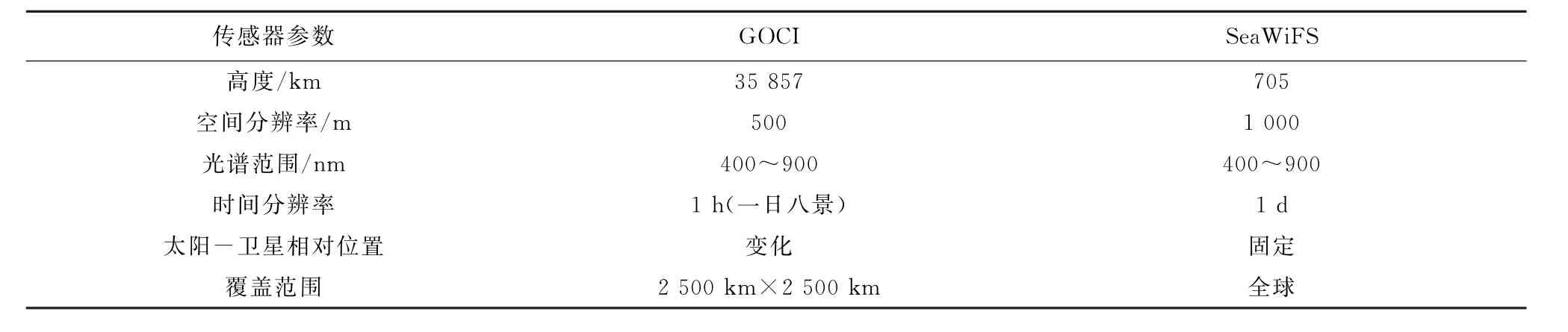
表1 GOCI相关参数及与SeaWiFS的对比Table 1 Comparison of the parameters between the GOCI and the SeaWiFS
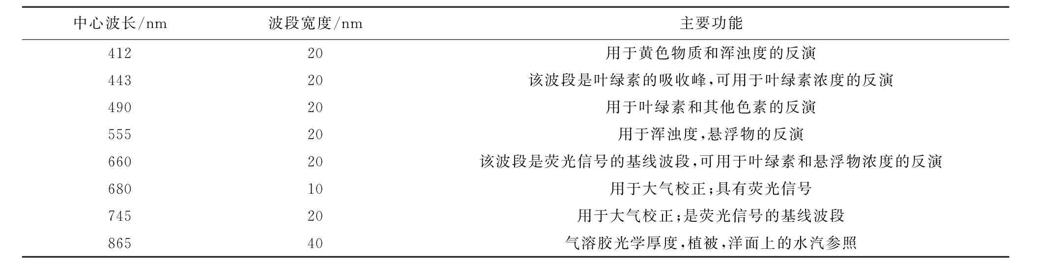
表2 GOCI的波段设置Table 2 GOCI band settings
KOSC专门开发用于GOCI数据处理的系统软件GDPS(GOCI Data Processing System)(图1),该软件包括数据浏览、数据处理、数据分析和数据输出等模块。其中,数据处理模块包含了大气校正算法和常用的水色遥感产品反演算法,输入GOCI L1B数据,可生成瑞利校正反射率(Rrc)、离水辐亮度(Lw)、归一化离水辐亮度(n Lw)、遥感反射率(Rrs)、叶绿素浓度、可溶性黄色有机质(CDOM)和悬浮物浓度(SPM)等L2级海洋分析数据产品。
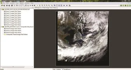
图1 GDPS软件界面Fig.1 Interface of GDPS software
2 GOCI研究进展
作为世界上第一颗静止轨道水色传感器,GOCI的发射升空引起了国内外众多海洋水色研究者的关注,目前已有大量基于GOCI数据开展的研究工作。作者对2011—2016年国内外主要期刊上发表的与GOCI数据相关的研究论文进行了统计和分析,结果如图2所示。针对GOCI的研究内容主要集中在GOCI数据处理、GOCI数据质量评价、海洋生态环境探测、海洋灾害探测、海洋动力过程探测及大气探测等方面,其中GOCI数据在海洋生态环境监测方面的应用最为广泛。

图2 GOCI相关研究统计Fig.2 Statistics of the researches related to the GOCI
2.1 GOCI数据处理方法
GOCI数据处理方法的研究主要集中在大气校正方面[8-11],Ahn等[8]基于SeaWiFS的标准大气校正算法,利用一个红光和近红外波段水体反射率的区域性经验关系,发展了GOCI数据的大气校正算法,该算法集成到了GDPS 1.1版本中,利用该算法进行大气校正后,GOCI的离水辐亮度与实测数据的比值接近于1,证明了该算法的有效性。Wang等[9]提出了一种利用近红外波段的GOCI浑浊水体大气校正算法,利用该方法对GOCI数据进行大气校正后,与MODIS卫星的观测数据具有很好的一致性。Kim等[11]针对GOCI L1级数据存在辐射偏差的问题,发展了一种杂散光校正方法,辐射偏差降至≤5%。
2.2 GOCI数据产品质量评价
数据质量的优劣势是水色卫星数据能否在海洋探测中发挥重要作用的关键[12-22]。Oh等[18-19]、Lee等[20]、Cho等[21]开展了GOCI在轨性能模拟、在轨光学性能评估和在轨性能变化分析等方面的研究。Moon等[14]利用船基观测数据评估了GOCI遥感反射率、叶绿素浓度、黄色物质和悬浮物等产品的精度,结果表明,GOCI可见光波段遥感反射率的平均相对偏差为18%~33%;叶绿素浓度产品与实测数据的相关性较低(<0.41),平均相对偏差为35%;黄色物质产品与实测数据没有显著的相关性;悬浮物产品与实测数据的相关性优于0.73。Lamquin等[16]基于MODIS,MERIS和实测数据评估GOCI辐亮度产品,结果表明,GOCI与MODIS,MERIS和实测数据具有较好的一致性,但GOCI的大气校正算法会将大量的浑浊水体掩膜掉,需要后续研究中进一步改进。Xiao等[22]基于2012—2013年的实测气溶胶光学厚度(AOD)数据评估了VIIRS,GOCI和MODIS的气溶胶产品,结果表明,与其他传感器相比,GOCI的气溶胶产品精度有待提高。
2.3 海洋生态环境探测
海洋生态环境参数的反演是水色卫星的重要应用之一,研究者利用GOCI数据在叶绿素浓度、悬浮物浓度、光合有效辐射等生态环境参数反演方面开展了大量的研究工作[23-39]。基于GOCI可逐时获取影像的优势,Choi等[26,29]、Ryu等[25]和刘猛等[24]分析了近岸悬浮泥沙的日变化特征。Qiu等[30]提出一种针对GOCI数据的黄河口悬浮泥沙浓度反演算法,该算法的平均相对偏差为34.2%;He等[31]利用GOCI数据发展了杭州湾水体悬浮泥沙反演算法,并利用反演结果分析了杭州湾悬浮泥沙的日变化特征。Qiu等[35]针对GOCI数据提出了一种高浑浊水体的浊度反演算法,利用该算法反演了2014-12-30浙江近岸海域8个时刻浊度,发现浊度从近岸到远岸,从上午到下午逐渐降低。金惠淑等[36]利用波段比值法建立了基于GOCI遥感影像的叶绿素a质量浓度反演模型,以此探讨利用GOCI数据估算湖泊水体富营养化程度的可能性,研究结果表明GOCI遥感数据具有对湖泊富营养化程度进行监测的潜力。Kim等[37]首先按照SPM浓度将水体分为三类,然后评估了波段比、荧光基线高度等叶绿素反演算法对GOCI的适用性,发现GOCI叶绿素浓度反演结果的平均偏差约为35%。Hwang等[38]基于长时间序列的GOCI数据分析了汉江口海域的悬浮物浓度变化。Kim等[39]基于GOCI数据估算了光合有效辐射(PAR),并基于实测数据进行了检验,同时与MODIS结果进行了对比,结果表明GOCI一天可获取8景数据的优势能有效评估PAR的日变化。
2.4 海洋灾害探测
在海洋灾害探测方面,国内外研究者利用GOCI数据开展了赤潮、绿潮等灾害的探测研究[40-48]。Son等[40]发展了针对GOCI数据的绿潮探测指数IGAG,该指数利用了555,660和745 nm三个波段,与NDVI, EVI和KOSC等绿潮探测常用方法相比,IGAG指数能否增强低密度绿潮在图像上的信号强度。Lou等[41]基于GOCI数据,采用修正的赤潮指数RI,分析了东中国海赤潮的日变化,结果表明,赤潮在14:30时面积达到最大。Hong等[42]利用GOCI和MODIS数据,对黄海入海高营养污水进行了监测。Young等[43]将卫星数据与数值模拟结合,分析了黄海和东海海面漂浮绿潮的漂移路径,发现漂浮绿潮的漂移由海流和风控制。Gong等[44]利用GOCI数据提取了黄海和渤海海冰的漂移方向和速度。Bak等[45]基于GOCI数据发展了一种赤潮监测算法,并与传统的赤潮监测算法进行了对比,可有效避免误检情况。刘文宋等[46]发展了一种基于GOCI数据的海冰厚度监测算法,并基于实测进行了检验,RMS为6.82 cm。
2.5 海洋动力过程探测
利用GOCI的逐时数据可进行海冰漂移速度、海表流场等的探测[49-57]。Lang等[49]利用GOCI逐时产品估算了渤海海冰的漂移速度,并分析了海冰漂移的影响因素及各因素的贡献率。Lou等[50]基于GOCI数据的逐时特性,利用MCC法估算了东中国海的海表流场,通过分析发现流速的短时间变化主要是受潮汐的影响。海洋中的中尺度涡能够引起海表层叶绿素浓度的变化,利用GOCI的叶绿素浓度产品可观测海洋的中尺度涡等海洋动力过程。Park等[51]利用GOCI的叶绿素浓度产品探测到了日本海的中尺度涡;Lim等[52]利用GOCI观测到了反气旋暖涡引起叶绿素浓度升高现象。此外,Park等[53-54]还利用GOCI逐时数据发展了潮汐订正模型。Hu等[55]基于GOCI数据,利用MCC方法计算了杭州湾海域的表面流场,同时评估了杭州湾海域的悬浮泥沙的快速沉降和再悬浮过程。Warren等[56]也利用GOCI和MCC方法数据开展了海表流场的分析工作。吴颉等[57]基于GOCI的总悬浮体数据分析了长江口海域表层悬浮体锋面的变化特征,并对其机制进行了初步分析。
2.6 大气探测
Lee等[58]利用GOCI数据生成了空间分辨率为500 m的海上气溶胶光学厚度产品,与地面观测数据的相关性为0.99。Park等[59]将GOCI逐时气溶胶产品与模式模拟相结合,用于监测PM运移事件的次数,证明了GOCI气溶胶产品在PM监测中的应用潜力。Choi等[60]利用GOCI数据反演了东亚地区陆地和海洋的气溶胶光学厚度(AOD)、细模态比(FMF)、单次散射比(SSA)等气溶胶光学性质。Yuan等[61]基于GOCI数据发展了一种海雾探测算法,并分析了海雾的逐时变化特征。
3 结 语
GOCI问世6 a间,在数据处理方法、数据产品精度评价等方面已开展相关研究工作,GOCI数据在海洋生态环境监测、海洋灾害监测、海洋动力过程探测和大气探测等方面,特别是逐时变化监测方面显示了其独特优势。
与此同时,值得注意的是,我国科学家在上述相关领域的工作还比较少,作为水色遥感领域的新兴方向,希望能引起我国科学家的充分重视,迎头赶上。
[1]RYU J H,HAN H J,CHO S,et al.Overview of geostationary ocean color imager(GOCI)and GOCI data processing system(GDPS) [J].Ocean Science Journal,2012,47(3):223-233.
[2]WAND M H,AHN J H,JIANG L D,et al.Ocean color products from the Korean Geostationary Ocean Color Imager(GOCI)[J].Optics Express,2013,21(3):3835-3849.
[3]LEE K H,KIM Y J,KIM G C,et al.Remote sensing of atmospheric aerosol and ocean color for the COMS/GOCI[C]∥AHN Y H,ANTOINE D,BONTEMPI P S,et al.Proceedings of SPIE 7861,Geostationary Ocean Color Imager(GOCI)Technical Development,Operation,and Applications.Incheon,Republic of Korea:SPIE Digital Library,2010,doi:10.1117/12.869533.
[4]MIN J E,RYU J H,AHN Y H.Spatial and temporal variations of the inherent and apparent optical properties in the sea areas around Korea[C]∥FROUINRJ,YOO H R,WON J S,et al.Proceedings of SPIE 7858,Remote Sensing of the Coastal Ocean,Land,and Atmosphere Environment.Incheon,Republic of Korea:SPIE Digital Library,2010:592-602.
[5]LEE B S,JUNG W C,LEE J H,et al.Development of the satellite ground control system for multi-mission geostationary satellite COMS [C]∥CRUZEN C A,GUNN J M,AMADIEU J.Space Operations:Exploration,Scientific Utilization,and Technology Development. Huntsvill,Alabama:American Institute for Aeronautics and Astronautics(AIAA),2010:3784-3792.
[6]HAN H J,RYU J H,CHO S,et al.Preliminary verification results of the geostationary ocean color satellite data processing software system[C]∥AHN Y H,ANTOINE D,BONTEMPI P S,et al.Proceedings of SPIE 7861,Geostationary Ocean Color Imager(GOCI) Technical Development,Operation,and Applications.Incheon,Republic of Korea:SPIE Digital Library,2010,doi:10.1117/12.869658. [7]HAN H J,RYU J H,YANG C S,et al.Preliminary analysis of data processing for geostationary ocean color remote sensing data from GOCI/COMS[C]∥MOREIRA A.2010 IEEE International Geoscience and Remote Sensing Symposium.Honolulu,Hawaii,USA:IEEE Geoscience and Remote Sensing Society,2010:3700-3703.
[8]AHN J H,PARK Y J,RYU J H,et al.Development of atmospheric correction algorithm for Geostationary Ocean Color Imager(GOCI) [J].Ocean Science Journal,2012,47(3):247-259.
[9]WANG M H,SHI W,JIANG L D.Atmospheric correction using near-infrared bands for satellite ocean color data processing in the turbid western Pacific region[J].Optics Express,2012,20(2):741-753.
[10]PARK W,WON J S.Radiometric cross-calibration of polar orbital sensors using Geostationary Ocean Color imager(GOCI)[C]∥OUWEHAND L.Proceedings of 1st Sentinel-2 Preparatory Symposium,ESRIN,Frascati,Italy:ESA Communications,2012:23-27.
[11]KIM W,MOON J E,AHN J H,et al.Evaluation of stray light correction for GOCI remote sensing reflectance using in situ measurements[J].Remote Sensing,2016,8(5):378.
[12]RUDDICK K,NEUKERMANS G,VANHELLEMONT Q,et al.Challenges and opportunities for geostationary ocean color remote sensing of regional seas:A review of recent results[J].Remote Sensing of Environment,2014,146(5):63-76.
[13]YANG C S,SONG J H.Geometric performance evaluation of the Geostationary Ocean Color Imager[J].Ocean Science Journal,2012, 47(3):235-246.
[14]MOON J E,PARK Y J,RYU J H,et al.Initial validation of GOCI water products against in situ data collected around Korean Peninsula for 2010—2011[J].Ocean Science Journal,2012,47(3):261-277.
[15]HU C M,FENG L,LEE Z P.Evaluation of GOCI sensitivity for At-Sensor radiance and GDPS-Retrieved Chlorophyll-a products[J]. Ocean Science Journal,2012,47(3):279-285.
[16]LAMQUIN N,MAZERAN C,DOXARAN D,et al.Assessment of GOCI radiometric products using MERIS,MODISand field measurements[J].Ocean Science Journal,2012,47(3):287-311.
[17]LEE Z P,JIANG M S,DAVIS C,et al.Impact of multiple satellite ocean color samplings in a day on assessing phytoplankton dynamics [J].Ocean Science Journal,2012,47(3):323-329.
[18]OH E,KIM S W,JEONG Y,et al.In-orbit image performance simulation for GOCI from integrated ray tracing computation[C]∥CHARLES R B,STELIOS P M,XAVIER N,et al.Proceedings of SPIE 8175,Remote Sensing of the Ocean,Sea Ice,Coastal Waters, and Large Water Regions 2011.Prague,Czech Republic:SPIE Digital Library,2011,doi:10.1117/12.897989.
[19]OH E,CHO S,AHN Y H,et al.In-orbit optical performance assessment of Geostationary Ocean Color Imager[C]∥JÓN A B.2012 IEEE International Geoscience and Remote Sensing Symposium(IGARSS).Munich,Germany:IEEE Geoscience and Remote Sensing Society,2012:4750-4753.
[20]LEE S J,CHO S,HAN H J,et al.In-orbit radiometric performance variations of geostationary ocean color Imager[C]∥CHARLES R B,STELIOS P M,XAVIER N,et al.Proceedings of SPIE 8175,Remote Sensing of the Ocean,Sea Ice,Coastal Waters,and Large Water Regions 2011.Prague,Czech Republic:SPIE,Bellingham Wash,ETATS-UNIS,2011,doi:10.1117/12.898372.
[21]CHO Y M.Earth observation mission operation of COMS during in-orbit test[C]∥MEYNART R,NEECK S P,SMIMODA H.Proceedings of SPIE 8176,Sensors,Systems,and Next-Generation Satellites XV.Prague,Czech Republic:SPIE Digital Library,2011: 817626-1-817626-10.
[22]XIAO Q,ZHANG H,CHOI M,et al.Evaluation of VIIRS,GOCI,and MODIS collection 6 AOD retrievals against ground sunphotometer observations over East Asia[J].Atmospheric Chemistry and Physics,2016,16(3):1255-1269.
[23]PENG X Y,SHEN F.Comparative analysis of suspended particulate matter concentration in Yangtze Estuary derived by several satellite sensors[J].Infrared,2014(4):31-37.彭翔翼,沈芳.多种卫星传感器反演长江口悬浮泥沙浓度的对比分析[J].红外,2014(4):31-37.
[24]LIU M,SHEN F,GE J Z,et al.Diurnal variation of suspended sediment concentration in Hangzhou Bay from geostationary satellite observation and its hydrodynamic analysis[J].Journal of Sediment Research,2013(1):7-13.刘猛,沈芳,葛建忠,等.静止轨道卫星观测杭州湾悬浮泥沙浓度的动态变化及动力分析[J].泥沙研究,2013(1):7-13.
[25]RUDDICK K,VANHELLEMONT Q,YAN J,et al.Variability of suspended particulate matter in the Bohai Sea from the Geostationary Ocean Color Imager(GOCI)[J].Ocean Science Journal,2012,47(3):331-345.
[26]CHOI J K,PARK Y J,AHN J H,et al.GOCI,the world's first geostationary ocean color observation satellite,for the monitoring of temporal variability in coastal water turbidity[J].Journal of Geophysical Research:Oceans,2012,117(C9):9004.
[27]RYU J H,CHOI J K,EOM J,et al.Temporal variation in Korean coastal waters using Geostationary Ocean Color Imager[J].Journal of Coastal Research,2011,64(S164):1731-1735.
[28]DOXARAN D,LAMQUIN N,PARK Y J,et al.Retrieval of the seawater reflectance for suspended solids monitoring in the East China Sea using MODIS,MERIS and GOCI satellite data[J].Remote Sensing of Environment,2014,146(5):36-48.
[29]CHOI J K,PARK Y J,LEE B R,et al.Application of the Geostationary Ocean Color Imager(GOCI)to mapping the temporal dynamics of coastal water turbidity[J].Remote Sensing of Environment,2014,146:24-35.
[30]QIU Z F.A simple optical model to estimate suspended particulate matter in Yellow River Estuary[J].Optics Express,2013,21(23): 27891-27904.
[31]HE X Q,BAI Y,PAN D L,et al.Using geostationary satellite ocean color data to map the diurnal dynamics of suspended particulate matter in coastal waters[J].Remote Sensing of Environment,2013,133(12):225-239.
[32]LIU H F,LI R J,PAN X S,et al.The application of GOCI data based remote sensing technology in the field of sediment research[J]. Applied Mechanics and Materials,2013(303-306):786-789.
[33]HUANG C C,ZOU J,LI Y M,et al.Assessment of NIR-red algorithms for observation of chlorophyll-a in highly turbid inland waters in China[J].ISPRS Journal of Photogrammetry and Remote Sensing,2014,93(7):29-39.
[34]PAHLEVAN N,LEE Z P,HU C M,et al.Diurnal remote sensing of coastal/oceanic waters:a radiometric analysis for geostationary coastal and air pollution events[J].Applied Optics,2014,53(4):648-665.
[35]QIU Z,ZHENG L,ZHOU Y,et al.Innovative GOCI algorithm to derive turbidity in highly turbid waters:a case study in the Zhejiang coastal area[J].Optics Express,2015,23(19):1179-1193.
[36]JIN H S,YU J S,SUN W C,et al.Monitoring lake eutrophication by GOCI remote sensing[J].Journal of Beijing Normal University (Natural Science),2013,49(2-3):271-274.金惠淑,鱼京善,孙文超,等.基于GOCI遥感数据的湖泊富营养化监测研究[J].北京师范大学学报(自然科学版),2013,49(2-3):271-274.
[37]KIM W,MOON J E,PARK Y J,et al.Evaluation of chlorophyll retrievals from Geostationary Ocean Color Imager(GOCI)for the North-East Asian region[J].Remote Sensing of Environment,2016,184:482-495.
[38]HWANG D J,CHOI J K,EOM J,et al.Long-term monitoring of suspended sediments concentration using GOCIand field data in Han river estuary,Korea[C]∥ZHU Q.2016 IEEE International Geoscience and Remote Sensing Symposium(IGARSS).IEEE Geoscience and Remote Sensing Society,2016,doi:10.1109/IGARSS.2016.7729636.
[39]KIM J,YANG H,CHOI J K,et al.Estimating photosynthetically available radiation from Geostationary Ocean Color Imager(GOCI) Data[J].Korean Journal of Remote Sensing,2016,32(3):253-262.
[40]SON Y B,MIN J E,RYU J H.Detecting massive green algae(Ulva prolifera)blooms in the Yellow Sea and East China Sea using Geostationary Ocean Color Imager(GOCI)data[J].Ocean Science Journal,2012,47(3):359-375.
[41]LOU X L,HU C M.Diurnal changes of a harmful algal bloom in the East China Sea:observations from GOCI[J].Remote Sensing of Environment,2014,140:562-572.
[42]HONG G H,YANG D B,LEE H M,et al.Surveillance of waste disposal activity at sea using satellite ocean color imagers:GOCI and MODIS[J].Ocean Science Journal,2012,47(3):387-394.
[43]SON Y B,CHOI B-J,KIM Y M,et al.Tracing floating green algae blooms in the Yellow Sea and the East China Sea using GOCI satellite data and Lagrangian transport simulations[J].Remote Sensing of Environment,2015,156:21-33.
[44]GONG S W,CHEN Z,ZHANG X.Extraction of drift direction and speed of sea ice of the Huanghai and Bohai Sea based on GOCI Satellite[C]∥YANG L,ZHAO M Q.Proceedings of the 2015 International Industrial Informatics and Computer Engineering Conference. Atlantis Press,2015,doi:10.2991/iiicec-15.2015.200.
[45]BAK S H,YOON H J.Study on red tide detection technique using satellite images in different times[J].Advanced Science and Technology Letters,2016,138:14-17.
[46]LIU W S,SHENG H,ZHANG X.Sea ice thickness estimation in the Bohai Sea using Geostationary Ocean Color Imager data[J].Haiyang Xuebao,2016,35(7):105-112.刘文宋,盛辉,张晰.基于GOCI数据渤海海冰厚度算法研究[J].海洋学报,2016,35(7): 105-112.
[47]SUN L E.Analysis of influence factors of green macroalage remote sensing detection[D].Qingdao:Qingdao University,2011.孙立娥.绿潮遥感探测影响因素分析[D].青岛:青岛大学,2011.
[48]CAI X Q.Remote sensing detection and diurnal variation research of green macro-algae bloom by Geostationary Ocean Color Image[D]. Qingdao:Ocean University of China,2012.蔡晓晴.基于静止轨道海洋水色卫星数据的绿潮遥感探测方法和逐时变化特征研究[D].青岛:中国海洋大学,2012.
[49]LANG W H,WU Q,ZHANG X,et al.Sea ice drift tracking in the Bohai Sea using Geostationary Ocean Color Imagery[J].Journal of Applied Remote Sensing,2014,8(1):083650-1-083650-16.
[50]LOU X L,SHI A Q,ZHANG H G.Coastal sea surface current observation with GOCI imagery[C]∥TIAN J W,MA J.Proceedings of SPIE 8921,MIPPR 2013:Remote Sensing Image Processing,Geographic Information Systems,and Other Applications.SPIE Digital Library,2013,doi:10.1117/12.2030969.
[51]PARK K A,WOO H J,RYU J H.Spatial scales of mesoscale eddies from GOCI Chlorophyll-a concentration images in the East/Japan Sea[J].Ocean Science Journal,2012,47(3):347-358.
[52]LIM J H,SON S,PARK J W,et al.Enhanced biological activity by an anticyclonic warm eddy during early spring in the East Sea(Japan Sea)detected by the geostationary ocean color satellite[J].Ocean Science Journal,2012,47(3):377-385.
[53]PARK W,SHIN J S,LEE Y K,et al.Tidal flat reflectance model accommodating tidal conditions using Geostationary Ocean Color Imager(GOCI):preliminary results[C]∥MOREIRA A,DESNOS Y L.Geoscience and Remote Sensing Symposium(IGARSS).Munich, Germany:IEEE Geoscience and Remote Sensing Society,2012,50(60),doi:10.1109/IGARSS.2012.6351861.
[54]PARK W,LEE Y K,SHIN J S.A tidal correction model for near-infrared(NIR)reflectance over tidal flats[J].Remote Sensing Letters,2013,4(9):833-842.
[55]HU Z,PAN D,HE X,et al.Assessment of the MCC method to estimate sea surface currents in highly turbid coastal waters from GOCI [J].International Journal of Remote Sensing,2016,38(2):572-597.
[56]WARREN M A,QUARTLY G D,SHUTLER J D,et al.Estimation of ocean surface currents from maximum cross correlation applied to GOCI geostationary satellite remote sensing data over the Tsushima(Korea)Straits[J].Journal of Geophysical Research:Oceans, 2016,121(9):6993-7009.
[57]WU J,ZHANG T L,HU J W.Temporal and spatial distribution of suspended sediment fronts in Yangtze river estuary and adjacent waters based on GOCI satellite data[J].Transactions of Oceanology and Limnology,2016(2):1-7.吴颉,张亭禄,胡静雯.基于GOCI卫星数据的长江口毗邻水域悬浮体锋面时空变化特征[J].海洋湖沼通报,2016(2):1-7.
[58]LEE K H,RYU J H,AHN J H,et al.First retrieval of data regarding spatial distribution of asian dust aerosol from the Geostationary Ocean Color Imager[J].Ocean Science Journal,2012,47:465-472.
[59]PARK M E,SONG C H,PARK R S,et al.New approach to monitor transboundary particulate pollution over Northeast Asia[J].Atmospheric Chemistry and Physics,2014,14(2):659-674.
[60]CHOI M,KIM J,LEE J,et al.GOCI Yonsei Aerosol Retrieval(YAER)algorithm and validation during DRAGON-NE Asia 2012 campaign[J].Atmospheric Measurement Techniques Discussions,2015,8(9):9565-9609.
[61]YUAN Y,QIU Z,SUN D,et al.Daytime sea fog retrieval based on GOCI data:a case study over the Yellow Sea[J].Optics Express, 2016,24(2):787-801.
Advances in the Application Study of the First Geostationary Ocean Color Imager
WANG Quan-bin1,QIN Ping2,ZHAO Xiao-chen3
(1.The First Institute of Oceanography,SOA,Qingdao 266061,China; 2.College of Information Science&Engineering,Ocean University of China,Qingdao 266100,China; 3.College of Marine Science and Biological Engineering,Qingdao University of Science&Technology,Qingdao 266042,China)
Marine environmental parameters and marine disasters such as red tide and green tide can change obviously within a day.Therefore,high frequency observations are required to meet the monitoring needs. The polar orbiting ocean color satellites are relatively lower in observation frequency,whereas the geostationary orbiting ocean color satellites have an absolute advantage in the observation frequency.The first geostationary orbiting ocean color satellite in the world,i.e.the Geostationary Ocean Color Imager(GOCI) was launched by South Korea in 2010,which has made the ocean color monitoring realized an hour level time resolution.Scientists around the world have quickly carried out a large amount research work by using the GOCI data.In the present paper,the major parameters and the data processing software of the GOCI remote sensor are introduced,and then the main advances in the researches of GOCI from its advent to 2016,which involve satellite data processing,product quality evaluation,marine environment and disaster monitoring,marine dynamic process detection,atmospheric sounding,and so on,are reviewed in order to provide references for the application of ocean color remote sensing in China,especially for the application of the geostationary ocean color remote sensing.
GOCI;geostationary;remote sensing application;ocean color remote sensing
December 12,2016
P715.7
A
1002-3682(2017)02-0071-08
10.3969/j.issn.1002-3682.2017.02.009
2016-12-12
中央级公益性科研院所基本科研业务费专项资金资助项目——中韩海洋功能区选划政策及技术方法比较研究(2015G19)
王泉斌(1980-),男,工程师,硕士,主要从事海洋环境与资源管理、中韩海洋领域合作等方面研究.E-mail:wangquanbin@fio. org.cn
猜你喜欢
遥感学报(2023年1期)2023-02-26 07:43:20
心理学报(2022年4期)2022-04-12 07:38:02
河北地质(2021年2期)2021-08-21 02:43:54
小资CHIC!ELEGANCE(2021年28期)2021-08-18 00:49:44
水泵技术(2021年3期)2021-08-14 02:09:20
雨花(2020年9期)2020-09-10 06:35:02
海洋科学(2017年5期)2017-10-14 15:40:15
海洋学报(2016年12期)2016-12-22 01:53:53
中国惯性技术学报(2015年1期)2015-12-19 13:12:17
中国扶贫(2015年15期)2015-08-10 11:17:16