A Study of Soil Nutrients in the Terrace Field Changed from Mountain Slope in Three Gorges Reservoir Region
, , , , ,
Key Laboratory of Surface Process and Environment Remote Sensing in the Three Gorges Reservoir Area/College of Geography and Tourism, Chongqing Normal University, Chongqing 401331, China
1 Introduction
China is one of the countries with the most serious soil erosion in the world, and the moderate and severe erosion area in Three Gorges Reservoir Region accounts for 64.55% of total soil erosion area in the reservoir region[1]. Therefore, there is an urgent need for comprehensive management of soil erosion in Three Gorges Reservoir Region. More than 90% of severe soil erosion in Three Gorges Reservoir Region occurs in the sloping land, and changing mountain slope into terrace field is an important measure to control the soil erosion of sloping land[2]. Implementing the project of changing mountain slope into terrace field, and enhancing the level terrace construction on the sloping land, is of great importance to achieving effective control over soil erosion in Three Gorges Reservoir Region, and thus contributing to the healthy development of local agriculture[3-4]. At present, the domestic scholars’ studies about the project of changing mountain slope into terrace field are mainly focused on design and classification of changing mountain slope into terrace field, water environmental effects, benefits of soil and water conservation and other aspects[5-8], but it lacks studies on the soil fertility of terrace field changed from sloping land. The assessment on soil fertility of the terrace field changed from mountain slope in Three Gorges Reservoir Region is also relatively rare, and the representative research is conducted by us[9-11]. Wushan County is a county located in Chongqing municipality. It occupies roughly 2957 km2. The deep valleys are intertwined with low mountains, with undulating terrain and steep slope. The region is dominated by yellow soil, limestone soil and mountain yellow brown soil. It features a humid subtropical monsoon climate, and rain and heat are in the same season. The average annual rainfall is 1049.3 mm. Since the 1970s, the project of changing mountain slope into terrace field has been constantly implemented in the region, Therefore, with the terrace field changed from mountain slope in Wushan County as the object of study, we use the spatio-temporal substitution method to analyze the soil nutrient status and trend about the terrace field changed from mountain slope under different length of implementation, in order to provide a theoretical reference for the effective fertilization in the soil after the implementation of the project and continuous advance of the project in Three Gorges Reservoir Region in the future.
2 Materials and methods
2.1SoilsamplingUsing the spatio-temporal substitution method[12], the soil samples were collected in August 2012. Five representative sampling points are selected from the terrace field changed from mountain slope in Wushan County (Longshan Village in Wuxia Town; Longdong Village in Quchi Township; Longjing Village in Longjing Township; Shuiku Village in Guandu Town; Qixing Village in Longjing Township). Five sampling points near the control sloping land (oa) with different length of implementation of changing mountain slope into terrace field are selected, namely 2a, 9a, 14a, 20a and 32a, respectively (2010, 2003, 1998, 1992 and 1970, respectively), and the 0-20 cm topsoil is mainly selected. To avoid the fertilization period and differences between the plots, the soil with similar fertilization and land use patterns is sampled. The sampling points are summarized in Table 1. The sampling is conducted from the top down sequentially. 1-2 kinds of crop are selected from each level of terrace field, and "S" method is used for sampling. After thoroughly mixing 3 repeated samples, 0.5 kg of sample is taken and placed in the corresponding No. sample bag. At the same time, GPS locator is used to determine the latitude and longitude of sampling points, and many parameters are recorded such as slope position, elevation, degree of vegetation cover, soil type and slope. A total of 190 samples are collected.
Table1Thesoilsamplingpointsunderdifferentlengthofimplementationofchangingmountainslopeintoterracefield

Lengthofimplementation/aNumberofsoilsamplesLocationAltitude/mTopographicfeatureCropSoiltype019109°46'E,31°09'N853—930LowhillsSoyYellowsoil235109°49'E,30°59'N903—970LowhillsPotatoYellowsoil947109°47'E,30°59'N958—989LowhillsCornYellowsoil1436109°46'E,31°06'N864—956LowhillsCornYellowsoil2029109°49'E,30°59'N922—1032LowhillsSweetpotatoYellowsoil3249109°47'E,31°03'N769—870LowhillsCornYellowsoil
Note: 0a is the control nearby sloping land.
2.2AnalysisofsoilsamplesThe content of 8 soil nutrients[total phosphorus, total potassium, organic matter, total nitrogen, ammonium nitrogen (NH4-N), nitrate nitrogen (NO3-N), available phosphorus and available potassium]is measured. Total nitrogen uses Kjeldahl method; total potassium uses sodium hydroxide melting flame photometry; ammonium nitrogen uses potassium chloride leaching flow injection method; nitrate nitrogen uses potassium chloride leaching ultraviolet colorimetry; organic matter uses potassium dichromate method; available phosphorus uses hydrochloric acid—sulfuric acid leaching method; total phosphorus uses NaOH alkali fusion—Mo-Sb colorimetry; available potassium uses neutral NH4OAc extraction—atomic absorption spectrophotometry[10]. At the same time, SPSS software is used to calculate the minimum value, maximum value, mean, standard deviation and coefficient of variation about the soil nutrient indicators to describe the overall quality of soil nutrients in the study area.
3 Results and analysis
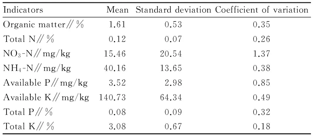
3.1OverallqualityofsoilnutrientsAs can be seen from Table 2, the average content of total nitrogen and available potassium is 0.12% and 140.73 mg/kg, respectively, reaching Standard III of soil nutrient grading in the second national land survey; the average content of organic matter is 1.61%, reaching Standard IV; the average content of available phosphorus is 3.52 mg/kg, reaching Standard V. It shows that the overall soil fertility is low in the study area. In addition, the coefficient of variation of nitrate nitrogen is 1.37 (strong variability), and the coefficient of variation of other indicators is 0.1 to 1 (moderate variability), indicating that the spatial heterogeneity of soil nutrients is small in the study area.
3.2Soilnutrienttrendswiththechangeinlengthofimplementationofchangingmountainslopeintoterracefield
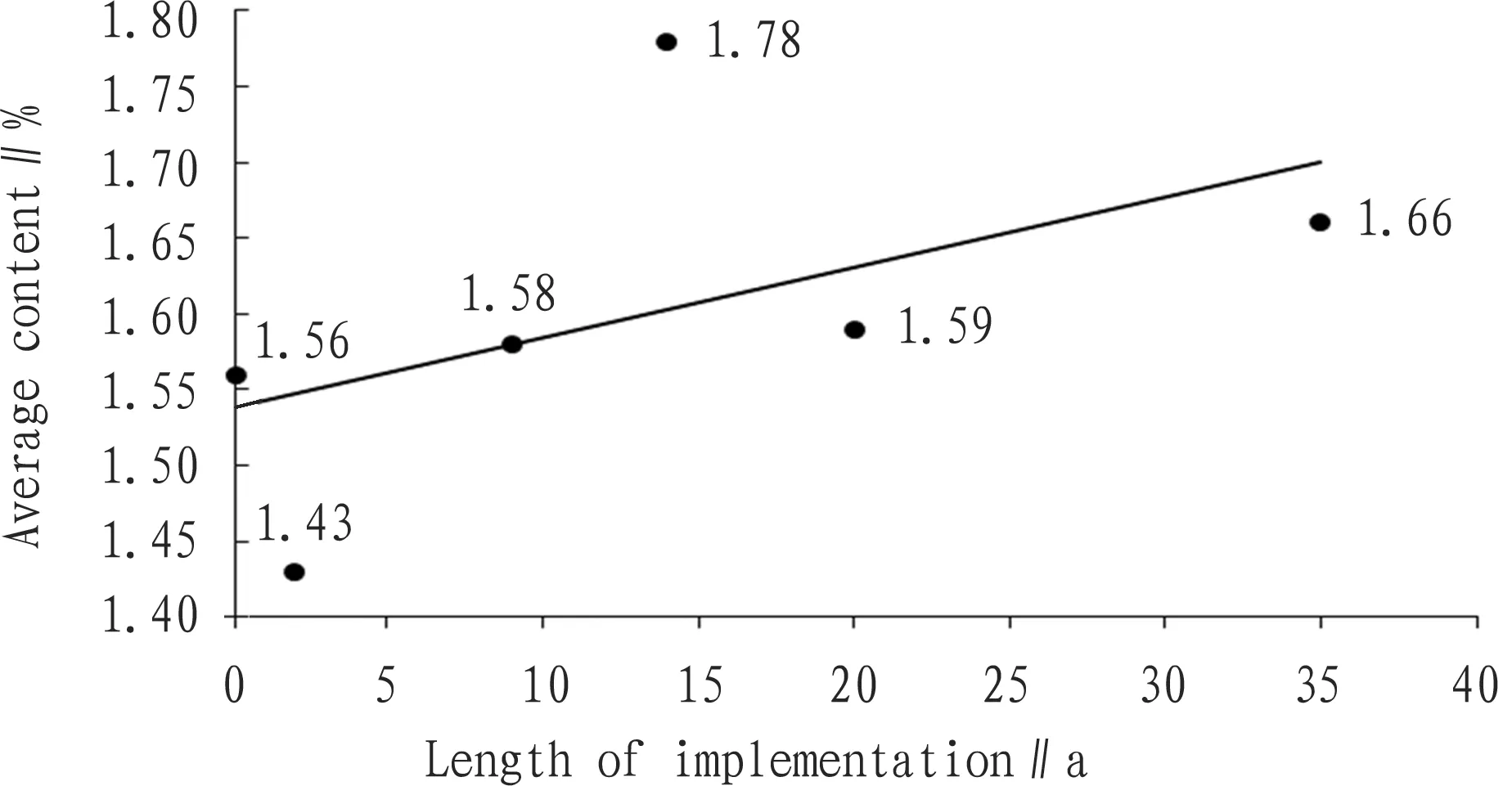
3.2.1Organic matter content. As can be seen from Fig. 1, with the increase in the length of implementation of changing mountain slope into terrace field, the average content of soil organic matter shows an overall upward trend, but the growth is slow. The relational analysis is conducted on the different length of reclamation and the average content of soil organic matter, and the correlation coefficientr=0.52, indicating that the different length of reclamation is significantly correlated with the average content of soil organic matter. For the soil reclaimed for 2 years, the average content of organic matter is 1.43%, and the average content of soil organic matter in the corresponding sloping land is 1.56%. The soil organic matter content in the terrace field changed from mountain slope for 2 years (implemented in 2010) is lower than in the control sloping land; the soil organic matter content in the terrace field changed from mountain slope for 14 years (implemented in 1998) (1.78%) is higher than in the terrace field changed from mountain slope for 9 years (1.58%) and 20 years (1.59%).
Table2Soilnutrientindicators

IndicatorsMeanStandarddeviationCoefficientofvariationOrganicmatter∥%1.610.530.35TotalN∥%0.120.070.26NO3-N∥mg/kg15.4620.541.37NH4-N∥mg/kg40.1613.650.38AvailableP∥mg/kg3.522.980.85AvailableK∥mg/kg140.7364.340.49TotalP∥%0.080.090.32TotalK∥%3.080.670.18

Fig.1Thetrendsofaveragesoilorganicmattercontentwiththechangeinthelengthofimplementationofchangingmountainslopeintoterracefield
3.2.2Nitrogen content. Fig. 2 shows that with the increase in the length of implementation of changing mountain slope into terrace field, soil total nitrogen content presents an overall upward trend, but the growth is slow; the average content of nitrate nitrogen and ammonium nitrogen shares similar trend with that of total nitrogen with the change in the length of reclamation. Compared to the sloping land, the average content of soil total nitrogen, nitrate nitrogen and ammonium nitrogen decreases in the terrace field changed from mountain slope for 2 years, and the average content of total nitrogen and ammonium nitrogen declines slightly, while the average content of nitrate nitrogen declines by 5.2 mg/kg. Compared with the soil in the terrace field changed from mountain slope for 2 years, the average content of soil total nitrogen, nitrate nitrogen and ammonium nitrogen shows a linear upward trend in the terrace field changed from mountain slope for 14 years (0.12%, 23.24 mg/kg and 43.1 mg/kg, respectively), and the average content of soil total nitrogen, nitrate nitrogen and ammonium nitrogen is higher than in the terrace field changed from mountain slope for 20 years (0.11%, 15.87 mg/kg and 39.01 mg/kg, respectively). It indicates that there is a sharp increase in the average content of soil total nitrogen, nitrate nitrogen and ammonium nitrogen in the terrace field changed from mountain slope for 14 years. It reflects that the project of changing mountain slope into terrace field will help prevent the loss of soil nitrogen, and with the increase in the length of implementation, continuous fertilization is conducive to the accumulation of soil nitrogen.

Fig.2Thetrendsofaveragesoilavailablenitrogen,potassium,phosphoruscontentwiththechangeinthelengthofimplementationofchangingmountainslopeintoterracefield

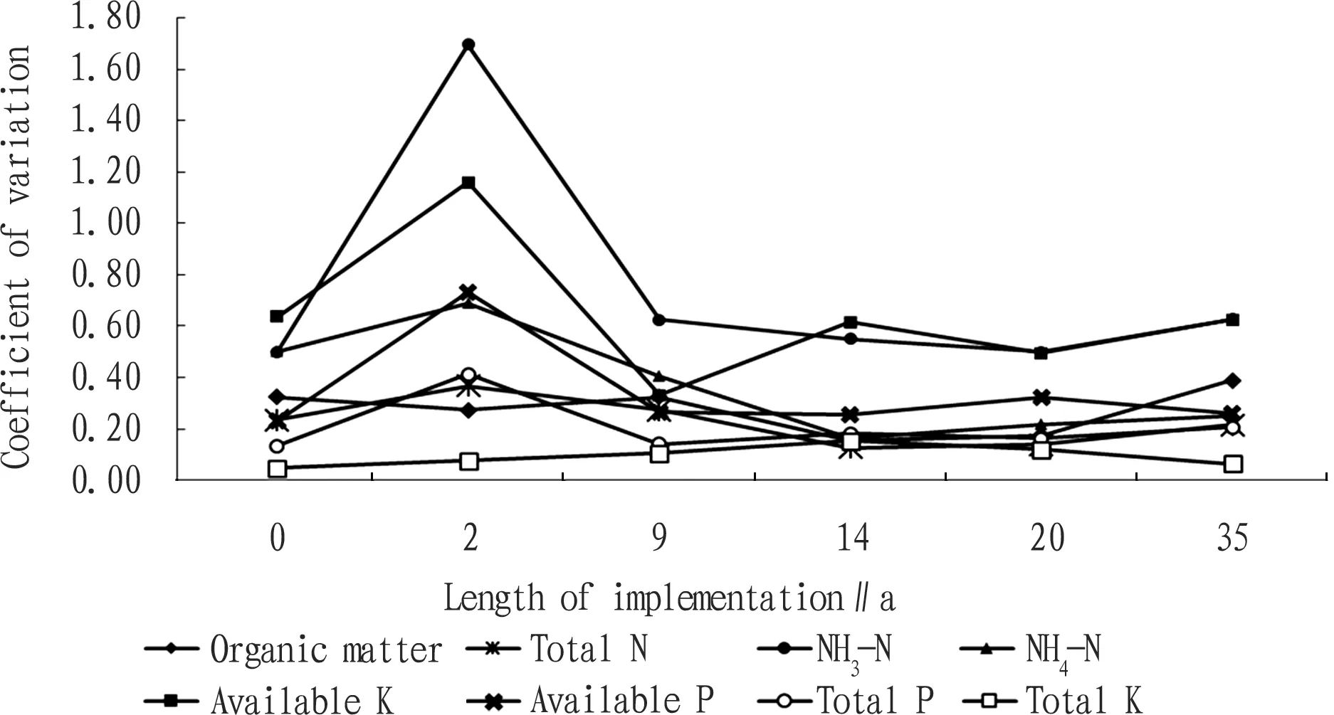
Fig.3Thetrendsofcoefficientofvariationofsoilnutrientindicatorswiththechangeinthelengthofimplementationofchangingmountainslopeintoterracefield
3.2.3Phosphorus and potassium content. As can be seen from Fig. 2, with the increase in the length of implementation of changing mountain slope into terrace field, the soil available phosphorus content shows an overall upward trend, but the growth is slow. The average content of available potassium and total potassium shares a similar trend with that of available phosphorus with the change in the length of implementation of changing mountain slope into terrace field. The average content of soil available phosphorus, available potassium and total potassium in the terrace field changed from mountain slope for 2 years, is 0.27 mg/kg, 0.22 mg/kg and 0.01% lower than in the sloping land, respectively; the average content of soil available phosphorus, available potassium and total potassium in the terrace field changed from mountain slope for 14 years is 1.93 mg/kg, 78.59 mg/kg and 0.41% higher than in the terrace field changed from mountain slope for 9 years, respectively, and 1.4 mg/kg, 72.96 mg/kg and 0.21% higher than in the terrace field changed from mountain slope for 20 years, respectively.
3.3CoefficientofvariationofsoilnutrientsunderdifferentlengthofimplementationofchangingmountainslopeintoterracefieldAs can be seen from Fig. 3, the coefficient of variation of soil nutrient indicators in the terrace field changed from mountain slope for 2 years (implemented in 2010) is greater than in the sloping land and the terrace field changed from mountain slope for different years except 2, indicating that the spatial heterogeneity of the soil nutrient indicators is highest for the terrace field changed from mountain slope for 2 years, and the content is not stable, while the spatial distribution of the soil nutrient indicators is stable for the sloping land and the terrace field changed from mountain slope for different years except 2.
4 Conclusions
This paper takes Wushan County for example, and uses the spatio-temporal substitution method to analyze the soil nutrient status and trend about the terrace field changed from mountain slope under different length of implementation. The results show that the soil fertility is generally low in the study area, and according to the soil nutrient grading standards in the second national land survey, the average content of total nitrogen, available potassium, organic matter and available phosphorus reaches Standard III, Standard III, Standard IV and Standard V, respectively, and the spatial heterogeneity of soil nutrients is small. Compared to the sloping land, the terrace field changed from mountain slope has increasing soil nutrients on the whole with the length of farming. With the increase in the length of implementation of changing mountain slope into terrace field, the soil erosion intensity is reduced in the original sloping land, and meanwhile, successive years of farming and organic and inorganic fertilizer input has effectively promoted the accumulation of nutrients. The mean of various indicators about soil nutrients in the terrace field changed from mountain slope for 2 years is lower than in the sloping land, and there is the biggest difference in soil fertility, while the mean of various indicators about soil nutrients in the terrace field changed from mountain slope for 14 years shows a linear upward trend, and the difference in soil fertility decreases.
[1] ZHAO J, GUO HZ, CHEN JQ,etal. Type classification and countermeasure of soil and water loss of Three Gorges Reservoir Area[J]. Soil and Water Conservation in China,2010(1): 16-18. (in Chinese).
[2] LIU YS, FENG DX. Sustainable potential and models of land use in the Three Gorges Reservoir Area [J].Geographical Research,2011(2):139-143. (in Chinese).
[3] FAN YF, LUO YJ, WEI CF. On level terrace engineering design of slope land in the hilly and mountainous,Southwestern China [J].Journal of Mountain Research,2010,28(5):560-565. (in Chinese).
[4] WEI J, HE XB. Review of soil conservation practices on sloping farmlands in Three-Gorge Reservoir Area [J].World Sci-tech R & D,2011,33(1):41-45. (in Chinese).
[5] JIAO JY, WANG WZ. Analysis on the quality of level terrace in the Loess Plateau and the effect of soil and water conservation [J].Transactions of the Chinese Society of Agricultural Engineering,1999,15(2):59-63. (in Chinese).
[6] WU FQ, ZHANG YB, SONG JL,etal. Current state and development trend of research on environmental effect of level terrace [J]. Journal of Soil and Water Conservation,2003,17(5):28-31. (in Chinese).
[7] ZHANG YT, WANG HG, LI ZY,etal. Soil and water conservation benefits of terracing on the slope [J].Research of Soil and Water Conservation,2001,8(3):9-12. (in Chinese).
[8] XUE S, LIU GB, ZHANG C,etal. Effects of terracing slope cropland on soil quality in hilly region of Loess Plateau [J].Transactions of the Chinese Society of Agricultural Engineering,2011,27(4): 310-316. (in Chinese).
[9] YANG M, CHEN GJ, WEI J,etal. Effects of different land use in terracing area on oil Nutrients: a case study of Wushan County in Chongqing [J].Journal of Chongqing Normal University:Natural Science Edition,2012,29(6):43-46. (in Chinese).
[10] LI PX, CHEN GJ, WEI J. Study on soil fertility evaluation of the typical terracing in Three Gorges Reservoir Area: a case study in Wushan County of Chongqing City [J].Journal of Chongqing Normal University:Natural Science Edition,2013,30(6):55-62. (in Chinese).
[11] DONG HW, CHEN GJ, GUO Y,etal. Study on the evaluation of soil fertility quality of different slope years in the Three Gorges Reservoir Area [J]. Soil and Water Conservation in China,2014(6):35-38. (in Chinese).
[12] JIAO F, WEN ZM, CONG HJ,etal. Comprehensive evaluation of soil fertility abandoned cropland based on attribute recognition model [J]. Journal of Soil and Water Conservation,2010,24(5):204-207. (in Chinese).
 Asian Agricultural Research2016年8期
- Asian Agricultural Research的其它文章
- On the Government’s Responsibility in China’s Rural Land Transfer
- Is the Farmland of China Sufficient?
——Analysis Based on the Second National Land Survey - Research on Management Mode of Small-scale Irrigation Works for Farmland Based on Self-governance
- Industrial Upgrade, Vocational Ability and Migrant Worker Education and Training
- Influence of Transplantation in Different Stage on Growth and Yield of Spring Maize in Shanxi Early Mature Area
- ECSRE Analysis on Late Comer Strategy for Folk Custom Eco-tourism of Southeast Chongqing in the New Normal State
