
Evaluation of eco-economic effects in relation to resettlement policy in Shulehe River Basin
2015-12-19 08:39:52LiLiuQiFeng
Li Liu ,Qi Feng
1.Key Laboratory of Ecohydrology of Inland River Basin,Cold and Arid Regions Environmental and Engineering Research Institute,Chinese Academy of Sciences,Lanzhou,Gansu 730000,China
2.University of Chinese Academy of Sciences,Beijing 100049,China
1 Introduction
In the context of climate change,environmental and ecological elements such as landscape,water resources and air quality are very sensitive in high pressure areas similar to western China.Thus,in large parts of China,people cannot maintain a livelihood due to limited resources or livelihood securities.However,in order to adapt to climate change or original natural conditions,single adaption could not act whilst adaptation strategies are defined as a general plan of approach for addressing the impacts of climate change(Fieldet al.,2014).Therefore,resettlement is one of the most significant methods to handle the imbalance of resource distribution and avoid natural disasters(Liuet al.,2011).For example,residents in the Three Gorges area moved to various localities in eastern China due to dam and reservoir construction on the Yangzi River(Xiaoet al.,2010).Also in western China,authorities often resettled residents outside their homeland due to topography and climate factors(Denget al.,2014).Since 1996–1997,over ten thousand people from Dingxi,Tianshui and Gannan have resettled in the Shulehe River Basin(Changet al.,2014).Although this policy has been widely discussed in terms of economy,society,agriculture,and the environment,overpopulation may lead to severe ecological pressure on water resources,land use,landscape and agriculture infrastructure in resettled fields(Zhanget al.,1997a,b),which will affect economic expansion within the market framework.Conversely,with proper governmental leadership and direction,positive ecological profits may ensue.For example,Changma reservoir was built in the Shulehe River Basin in 1997 in order to supply agricultural irrigation for new residents that migrated from Dingxi and Longxi(Yang,2009).However,few studies focus on the changes of natural resources' endowments due to resettlement,and especially the lacking are analysis on the effects of resettlement policy on aspects of ecology and economy(Liu and Feng,2015).Thus,in order to estimate environmental effects due to resettlement policies since 1996–1997,we studied systems that can adapt to climate change such as cropland development,environmental management and crop systems of the Shulehe River Basin(Parryet al.,1992).
2 Situation of study area
The Shulehe River Basin(38°00′N–42°48′N,92°11′E–98°30′E)is located in the western part of the Hexi Corridor,and is one of three inland river catchments in Gansu Province(the other two are Shiyanghe and Heihe river basins).The Shulehe River Basin is 670 km long,covers an area of 41,300 km2,sources from Tuolenanshan,and west terminal of Qilian Mountains,Qinghai Province(Liet al.,2014).The catchment includes Subei Mongolia Autonomous County,Yumen City,and Guazhou County.Thus,it could be divided as upper stream area from Tuole to Changmabao,mid stream from Changmabao to Shuangta,and down stream from Shuangta to Hala Lake,covering three irrigation districts of Changma,Shuangta and Huahai,respectively(Maet al.,2014).Compared with the Heihe and Shiyanghe river basins,development delays provided relatively abundant water resources for the Shulehe River Basin due to agricultural scales and construction strengths(Zhanget al.,2014).Nevertheless,since implementation of the resettlement policy,agricultural development almost quadrupled producing increased pressure on water resources as well as the ecological environment.
In this study,we focused on the irrigation districts of Changma,Huahai and Shuangta of Shulehe River Basin.Changma covers 13 administrative towns,Shuangta covers six administrative towns,and Huahai covers seven administrative towns(Figure 1).In these areas,annual precipitation is less than 100 mm while evaporation approaches 3,000–4,000 mm.Thus,water is a scarce resource when evaporation is over thirty times that of precipitation(Sunet al.,2011).Therefore,these districts belong to a typical extreme arid region,frequently suffering desertification,sand storms and soil salinization.
The migration of people in this region of China is composed of two parts.First is the movement of people from Dingxi and Longxi where soil and farming land is of extremely poor quality.Second is the welcoming of these people into Changma where projects were built and accomplished on schedule to handle the influx.
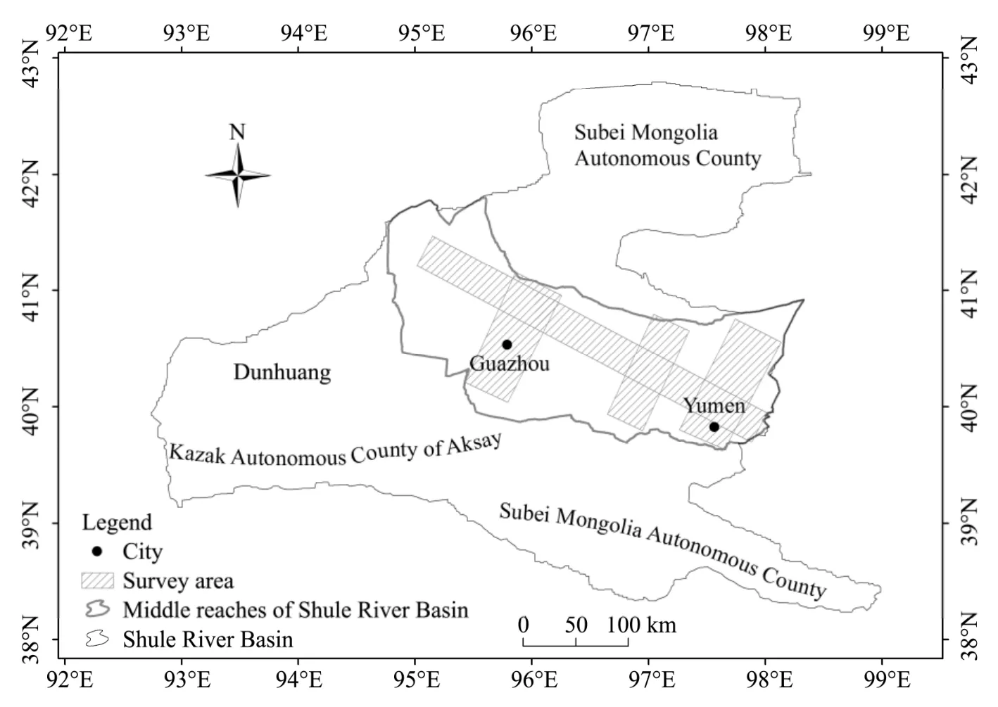
Figure 1 Position of Yumen and Guazhou located in the Shulehe River Basin.Survey area is a combination of four irrigation sections
3 Ecological changes and economical variations after the commencement of resettlement policy
From 1996 to 1997,in the Shulehe River Basin,there was an uneven distribution of soil and water resources and still the limit factors to serve the migrations.In addition,the environment is relatively vulnerable and once disturbed is unrecoverable.Therefore,excess development without proper protection will bring serious ecological effects.In this study,we compiled data from remote sensing and statistical yearbooks(Guazhou,1996–2005,2005–2013;Yumen,2001–2012)in order to estimate comprehensive environmental and ecological effects due to the resettlement policy,from the perspective of land use,water,agriculture,and forest resources.We also provided face to face questionnaires to the local residents to catalog livelihood and ecological changes due to implementation of the resettlement policy.
3.1 Ecological service value variation based on arable land changes
Initially,arable land is the foremost characteristic for the resettlement projection due to land use cover changes and barren land exploration coming with the resettlement.From 1999 to 2013,in the area of Yumen,arable land expanded from 2.68×10⁸m2to 3.54×10⁸m2,increasing by nearly 620×104m2/a,while in the area of Guazhou,arable land expanded nearly two-fold,from 1.52×10⁸m2to 3.79×10⁸m2(Figure 2).Meanwhile,in 2006,due administrative regional changes,Guazhou County was renamed and rearranged from the previous Anxi County.Thus,arable land may need to be re-calibrated.However,the sum of both arable lands of Yumen and Guazhou may reflect the effort of reclaiming wastelands and vacant arable lands in order to feed a large influx of people.Total arable land area increased by 3.1×10⁸m2during which urban construction lands grew at a fast pace.This enlargement of arable land in the Shulehe River Basin is the result of the local government's protection policy during urbanization over the past 20 years.
3.2 Water resources
Regional water resources are derived from inner land river catchments such as Heihe and Shiyanghe river basins,often from sources including glacier melt,precipitation and the aquifer.In the Shulehe River Basin,glacier melt contributes 31.4% to surface runoff,while rainfall contributes 39.5% and the aquifer contributes 29.1%.From 1996 to 2010,there were two main variations,aquifer salinity and total amount of water resources,in the context of climatic change and interaction between farming and grazing policies.These two factors have a tremendous impact on crop quality as wheat and corn require large areas of flooded irrigation.The most significant,as in most seriously arid lands,is the amount of water resources,especially the aquifer level.Due to topography of the middle stream of Shulehe River Basin,which is funnel-form,detection of the aquifer level in the mid of Yumen and Guazhou is comparable to the aquifer level for the entire Shulehe River Basin.We calculated the average depths of three irrigation districts including Changma,Shuangta and Huahai which are all common monitoring spots of 17.56 m,13.07 m and 24.06 m,respectively,with an annual variation trend of-0.12 m,-0.34 m and-0.63 m,respectively.Thus,the aquifer level decreased slightly while shallow groundwater in the area was consistently utilized as the main irrigated source for large scale crops and other economic necessities.
In arid lands,predominant tool for agricultural irrigation is the motorized water well,the construction of which is often instituted by the water department and local government.In Yumen,the number of motorized wells increased by 357,in Guazhou it increased by roughly 1,200,and total number of motorized wells was 2,168 in 2013 for the three irrigation areas(Figure 3).During our survey,the local hydraulic department set a special budget for well construction but there was a serious depreciation due to lack of maintenance and repair which should be then taken into account.
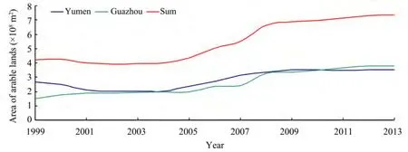
Figure 2 Arable land areas in cities of Yumen,Guazhou and combination of from 1999 to 2013
3.3 Agricultural development
Crops are the main source for the fundamental needs of residents of which all agricultural structures depend upon.Croplands in Yumen increased by 0.03×10⁸m2while in Guazhou they increased by 0.13×10⁸m2from 2001 to 2012(Figure 4),which is the upper limit for sustainable crop production.
Meanwhile,the presence of only grain planting did not render peasants "Xiaokang",which means that varied economic necessities should be encouraged for this area.In this area,cotton and medicinals such as Suoyang are the most popular economic activity.In this study,we procured statistical data from yearbooks to estimate the area of economic necessities including cotton,melon and Chinese medicines which are the pillar industries in the Shulehe River Basin.The scale of economic necessities soared from 2001 to 2012 in both Yumen and Guazhou(Figure 5).For respectively,Yumen claimed three times of area in economic planting than 2001 while only the time between the years from 2003 to 2004 decreased,which was due to the city's relocation because of not being able to meet developmental needs after 50 years of consistent resources exploration.
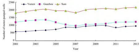
Figure 3 Number of motorized wells in Yumen and Guazhou

Figure 4 Area of croplands in Yumen and Guazhou
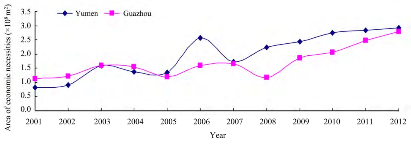
Figure 5 Area of economic necessities in Yumen and Guazhou
3.4 Animal husbandry development
The Shulehe River Basin is a typical agro-pastoral transition zone where minorities like Hui and Dongxiang lived,where cattle,sheep and pigs are set as the primary herd and livestock.In this study,we calculated the number of cattle,including sheep and pigs bred by resettled residents mainly in Yumen as the main herd region(Figure 6).The number of cattle maintains a stable level of 1×10⁴while pigs declined to a low level with is a reflection of the market.The number of sheep soared from 17.44×10⁴to 73.57×10⁴which accommodated the daily meat consumption.

Figure 6 Number of herd and livestock in Shulehe River Basin from 2001 to 2012
3.5 Conversion of degraded farm land into forest and grass land
The planting of trees and grasslands is a widely accepted method in resisting sand storms and soil erosion which are the main climate disasters in this area.In the Shulehe River Basin since 2000,the conversion from farm land into forest and grasslands expanded over ten times(Figure 7).In Yumen,from 2001 to 2012,a total of 1.2×10⁸m2of land was converted to forests,of which 0.2×10⁸m2was farmland,0.4×108m2was barren land,and 0.6×10⁸m2was desert and Gobi.This conversion fulfilled the ecological protection mission which accompanied the resettlement policy.From the standpoint of local residents,afforestation played an effective role in desertification prevention and treatment.

Figure 7 Area of afforestation in Yumen
4 Discussions
In the Shulehe River Basin,as perceived by resettled residents,climate change creates a significant challenge to regional development and agriculture structures in terms of water resources,drought and sand storms.Hence,conservation mechanisms in agriculture or insurances for plantings when they suffer climatic disasters are very important,accompanied with forecast and precautions for individual disasters(Egohet al.,2007).However,the comprehensive design,planning,and balanced industrial development when first,second and third industries improved together would provide a positive trend for the residents in terms of sufficient recycled water during droughts and sand storms(Lanet al.,2014).In addition,although the residents' livelihood,agricultural production and livestock placed a huge burden on the environment,resulting in desertification to some extent,benefits where achieved in terms of environmental protection and effective positive feedback.For example,there has been considerable profits in Yanchi County from the forbidden of grazing in recent 20 years(Yanget al.,2005).Although pressure on the environment did not reach to extreme limits,one cannot ignore unreasonable exploitation of the environment.For example,livestock and crops,both of which underpin the local economy of the Shulehe River Basin,currently fluctuate with the market.Thus,the amount of cattle,sheep,and crops must adapt to market demands.This demands that the local government help residents to regulate and adjust agricultural production and at the same time balance the needs of resources and the environment against monetary profits(Costanzaet al.,2012).
The aforementioned considerations offer confidence in sustainable development of the Shulehe River Basin which can be applied to similar inland river basins such as Heihe and Shiyanghe.Certainly,the aforementioned positive conditions suggest that one does not need to loosen environment protection and resource recycling standards in order to provide sustainable development.
5 Conclusion and prospects
The resettlement policy of 1997 in the Shulehe River Basin was very successful in fulfilling its original plan.Initially,from 1997 to 2012,resettlement and infrastructural development occurred,where arable land,crops and economic necessities grew at an incredible rate,thus enriching the residents as well as herds and livestock.Subsequent efforts included water recycling,and signs of environmental balance after satisfying the requirements of resettlement and urbanization.Thus,ecological development requires sustainable awareness,such as afforestation triggered by governmental advocates and spontaneous activities.In addition,market adjustments in order to renew all industries and the intellectual requirements in regional construction where both the desiderata are closely having something to do with education and propagation.All in all,sustainable development is a comprehensive project so that only evaluation from all aspects ranged from human beings and landscapes could be trustful.
The authors would like to thank the editors and reviewers for their helpful comments.This study was supported by the Cooperation-Innovation Team Project of Chinese Academy of Sciences;the National Natural Science Foundation of China(Nos.30970492 and 91025002).
Chang GY,Zhang WX,2014.Ecological civilization-based rethinking of large-scale immigration and land development along Shule River.Journal of Lanzhou University(Natural Sciences),50(3):405–409.DOI:10.13885/j.issn.0455-2059.2014.03.017.
Costanza R,Kubiszewski I,2012.The authorship structure of"ecosystem services" as a transdisciplinary field of scholarship.Ecosystem Services,1(1):16–25.DOI:10.1016/j.ecoser.2012.06.002.
Deng X,Bai X,2014.Sustainable urbanization in western China.Environment:Science and Policy for Sustainable Development,56(3):12–24.
Egoh B,Rouget M,Reyers B,et al.,2007.Integrating ecosystem services into conservation assessments:a review.Ecological Economics,63(4):714–721.DOI:10.1016/j.ecolecon.2007.04.007.
Field CB,Barros VR,Dokken DJ,et al.,2014.Summary for policymakers.In:Climate Change 2014:Impacts,Adaptation,and Vulnerability.Part A:Global and Sectorial Aspects.Contribution of Working Group II to the Fifth Assessment Report of the Intergovernmental Panel on Climate Change.Cambridge,United Kingdom and New York,NY,USA:Cambridge University Press.
Guazhou Bureau of Statistics,1996–2005,2005–2013.Guazhou Statistical Yearbook.
Lan Y,Hu X,Ding H,et al.,2014.Multiple time scales analysis of jump and variation of air temperature in mountain area of Hexi Inland River Basin in the past more than 50 years.Mountain Research,32(2):163–170.
Li JS,Wang J,Li B,et al.,2014.Groundwater in the Shule River irrigation area of Hexi Corridor:characteristics and current situation.Journal of Glaciology and Geocryology,36(5):1288–1297.DOI:10.7522/j.issn.1000-0240.2014.0154.
Liu L,Feng Q,2015.A review of advances in payment of ecological services research in relation to a catchment.Journal of Desert Research,35(3):694–699.DOI:10.7522/J.issn.1000.694X.2014.00177.
Liu NN,Wang LC,Zhang XY,2011.Analysis on the impact of immigrates allocation project on the ecological environment of Shule River.Journal of Anhui Agriculture Science,39(11):6696–6698.
Ma Q,Li D,Liao J,et al.,2014.Analysis of land use change and its driving forces in the Oasis of Shule River middle and lower reaches.Economic Geography,34(1):148–155.
Parry ML,Swaminathan MS,1992.Effect of Climate Change on Food Production.Cambridge:Cambridge University Press.
Sun XK,Zhou LH,Chen Y,2011.The adaptive countermeasures against climate change in Shulehe River Basin,China.Journal of Desert Research,31(5):1316–1322.
Xiao P,Qin CJ,2010.Policy options for the resolution of involuntary policy resettlements due to hydro-projects in the context of urbanization in China—A case study from longtan reservoir.Resources and Environment in the Yangtze Basin,19(4):358–363.
Yang GS,Qu YG,Dong GR,et al.,2005.Study on ecology protection in lower reaches area of the Shulehe River.Journal of Desert Research,25(4):472–482.
Yang YC,2009.Scientific management on water resources in Shule River for sustainable development.Development,222(4):12–13.
Yumen Bureau of Statistics,2001–2012.Yumen Statistical Yearbook.
Zhang Q,Zhang T,Xiao YK,et al.,1997a.An analysis on evolution trend of ecological environment in the in-migration area of the Shule River Basin.Journal of Arid Land Resources and Environment,11(3):34–41.DOI:10.13448/j.cnki.jalre.1997.03.006.
Zhang X,Zhang Y,Xu H,et al.,2014.Mountainous runoff change in three inland river basin in Hexi Corridor and its influencing factors.Journal of Arid Land Resources and Environment,28(4):66–72.
Zhang ZL,Zhang T,Zhang Q,1997b.Analysis of the impact of immigration on ecological environment in Shule River.Chinese Journal of Population Science,62(5):16–21.
 Sciences in Cold and Arid Regions2015年6期
- Sciences in Cold and Arid Regions的其它文章
- Water accounting for conjunctive groundwater and surface water irrigation sources:A case study in the middle Heihe River Basin of arid northwestern China
- Analysis of permanent deformations of railway embankments under repeated vehicle loadings in permafrost regions
- Land use and land cover change processes in China's eastern Loess Plateau
- Comparative anatomical studies of Artocarpus altilis(Parkinson)Fosberg and Artocarpus communis(J.R.&G.Forster)in Nigeria
- Vertical distribution of soil moisture and surface sandy soil wind erosion for different types of sand dune on the southeastern margin of the Mu Us Sandy Land,China
- Study of seasonal snow cover influencing the ground thermal regime on western flank of Da Xing'anling Mountains,northeastern China