Role of a Meso-γ Vortex in Meiyu Torrential Rainfall over the Hangzhou Bay,China:An Observational Study
ZHAI Guoqing(翟国庆),ZHANG Honglei(张红蕾),SHEN Hangfeng(沈杭锋),ZHU Peijun(朱佩君), SU Tao(苏涛), and LI Xiaofan*(李小凡)
1 School of Earth Sciences,Zhejiang University,Hangzhou 310027
2 Hangzhou Weather Bureau,Hangzhou 310007
Role of a Meso-γ Vortex in Meiyu Torrential Rainfall over the Hangzhou Bay,China:An Observational Study
ZHAI Guoqing1(翟国庆),ZHANG Honglei1(张红蕾),SHEN Hangfeng2(沈杭锋),ZHU Peijun1(朱佩君), SU Tao1(苏涛), and LI Xiaofan1*(李小凡)
1 School of Earth Sciences,Zhejiang University,Hangzhou 310027
2 Hangzhou Weather Bureau,Hangzhou 310007
A mesoscale torrential rainfall event that occurred over eastern China in June 2013 is analyzed by using observational data.The results show that a mesoscale convergence line and a weak convective cloud line formed over the northern part of the Hangzhou Bay during the onset of the torrential rainfall event.A meso-vortex appeared over the confluence point of northeasterly flow associated with the Yellow-Sea high, easterly flow from rainfall area,and southeasterly flow from the Hangzhou Bay.The meso-vortex with a horizontal scale of 10–20 km lasted for about 1 h for stable surface circulations.The analysis of radar retrieval reveals that the meso-vortex in the boundary layer occurred at the south of strong radar echo.The formation of the meso-vortex turned to enhance convergence and cyclonic vorticity in the lower troposphere, which strengthened updrafts that are tilted into convective clouds and caused torrential rainfall.Thus, the occurrence of the meso-vortex in boundary layer is one of the mechanisms that are responsible for the enhancement of convective development.
torrential rainfall,triggering mechanism,mesoscale analysis,mesoscale disturbance vortex, lower tropospheric convergence line
1.Introduction
China is one of the main countries affected by monsoon.Rainbands associated with southwesterly winds occur continuously over the Jiang-Huai Valley in June and July.Torrential rainfall in the Jiang-Huai Valley causes severe floods.Such torrential rainfall events are often called the Jiang-Huai Meiyu.Previous studies have concluded that the torrential rainfall during Meiyu is caused by mesoscale convective systems(MCSs)or small convective cells.Ding(1993), Lu et al.(1997),Tao et al.(2001,2004),Gao et al.(2003),Zhang et al.(2004),and Wang et al. (2014)found that the Jiang-Huai Meiyu is associated with development of such MCSs.Research into the mechanisms involved in major Chinese weather events and into forecasting theory for these events has led to the discovery of important mechanisms responsible for the genesis and development of the MCSs associated with the torrential rainfall caused by Jiang-Huai Meiyu fronts(Ni and Zhou,2004;Ni et al.,2004). Zhao et al.(2004)found that MCSs frequently form and develop along wind shear lines over a Meiyu front and that torrential rainfall over a Meiyu front occurs because of the occurrence of β-or γ-mesoscale systems.
Some studies found that low-level vortex has great influences on the following convective system(e.g., Che et al.,2013;Tanamachi et al.,2013a,b;Zheng et al.,2013). Recent studies revealed that small perturbed vortices were clearly identifiable over the boundary layers before mesoscale vortices formed in
the lower troposphere(Wang et al.,2003;Zhai et al.,2003,2007;Shen et al.,2013).The horizontal scale of these small vortices was about 100 km or less, and the duration of which was about a few hours. These vortices are closely associated with torrential rainfall,and are called planetary boundary mesoscale disturbed vortices(PMDV;Shen et al.,2012).The formation processes of MCSs are not well understood; attention has previously been paid to the involvement of MCSs in Meiyu torrential rainfall.Liao et al.(2010) demonstrated that the surface baroclinicity can be intensified by downdraft-induced cold outflows from a well-developed MαCS(meso-α convective system with a horizontal scale of 200–2000 km),causing warm and humid southwesterly flows to occur and cyclonic circulations along the surface convergence line to be strengthened.This would lead to a new meso-β cyclonic vortex being generated.In the aforementioned studies,it was found that the cyclonic disturbances occurred over the Meiyu front along the wind shear lines, and besides the aforementioned studies,Zhang et al. (2010),Jiang and Wang(2012),Jiang et al.(2013), and others also found this phenomenon.
The small size and complicated evolution of the disturbed vortices during the Jiang-Huai Meiyu,and the scarcity of real-time observational data mean that it is difficult to analyze these vortices,and in particular,they are barely identified during their onset phase. Conversely,small vortices are often ignored when conventional observational data are analyzed.The objective of the present study is to use non-conventional observation data to examine the characteristics and impacts of a meso-γ vortex over a coastal area and the middle and lower reaches of the Yangtze River, and to identify the relationship between such a vortex and the torrential rainfall.
Hangzhou is located at the exit of the Qiantang River,which flows into the Hangzhou Bay.A torrential rainfall event occurred in Hangzhou in the afternoon of 24 June 2013.During the event,convective cells associated with Meiyu fronts had developed.The rainfall event started after 0900 UTC,and the maximum rainfall rate was 107 mm h−1.More than 150 mm of rain fell in northern Hangzhou in a period of 2 h. The event was therefore classified as torrential rainfall. The event caused massive floods in the northern area of Hangzhou,and these floods resulted in significant economic loss including extensive property damage. A mesoscale analysis of the processes involved in this short-time and small-scale torrential rainfall event was performed by using 10-min high-spatial-resolution rain and radar observation data.The data and methodology used to conduct mesoscale analysis are briefly described in Section 2.Discription of the rainfall event is provided in Section 3.The results from the mesoscale observation analysis are presented in Section 4,and conclusions are drawn in Section 5.
2.Data and methodology
The NCEP Final(FNL)Operational Global analysis data were employed in this study.The data accommodate observations from land surface,ship,rawinsonde,pibal,aircraft,satellite,and other platforms, and can be downloaded at http://rda.ucar.edu/data sets/ds083.2. The observations have been incorporated through quality control and assimilated by a data assimilation system.The data have a horizontal resolution of 1°×1°and are vertically resolved into 26 levels.
The brightness temperature(TBB)at the top of cloud is measured by the Chinese geostationary meteorological satellite FY2E and the data can be downloaded at http://satellite.cma.gov.cn/portalsite /Data/Satellite.aspx.The TBB data have a horizontal resolution of 0.1°×0.1°and an accuracy of 1 K.Objective analyses were performed by using the Cressman method,and the data were interpolated to grids on a 10-km resolution.
The torrential rainfall event occurred 15 km from the Hangzhou radar station.Wind data were retrieved by performing 4DVAR analysis(Liu et al.,2003,Liu Liping et al.,2005,Liu Shuyuan et al.,2005),in which the radial velocity data and reflectivity factors determined by the Doppler radar were directly assimilated into a three-dimensional cloud-resolving model(Sun and Crook,1997,2001; Crook and Sun,2002).The aims were to determine
the optimal initial model variables that allowed the model output to approach the observations at certain times and places as closely as possible,and to allow radar data to minimize the difference between the model output and the observations to be acquired.
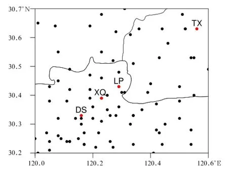
Fig. 1. Locations of the conventional and automatic weather stations that provided the data in and around the Hangzhou(HZ)city.DS:Desheng;XQ:Xingqiao;LP: Linping;TX:Tongxiang.
Thedatafrom conventionaland automatic weather stations were analyzed in this study.The stations that provided the data are densely distributed over eastern China,and their locations are shown in Fig.1.In this figure,there are 5 conventional stations and 67 automatic weather stations.The station data were objectively interpolated into grid on a 2-km resolution.
3.The torrential rainfall event
3.1 Large-scale background
The Meiyu in 2013 occurred over the middle and lower reaches of the Yangtze River,including northern Zhejiang Province,in late June 2013.The large-scale background was examined by analyzing the NCEP/NCAR reanalysis data with a resolution of 1°×1°. There was a weak east-west oriented wind shear line at 0600 UTC 24 June,from the eastern part of a low pressure area near Sichuan Province to a ridge over the eastern coast around 30°N at 850 hPa (Fig.2a).This caused southwesterly winds to prevail over the southeastern and coastal areas of Zhejiang Province.The northern part of Zhejiang Province,including the Jiaxing area and the Hangzhou Bay,was covered by a weak lower-tropospheric wind shear line. The surface map(Fig.2b)showes that there was a surface warm-type shear line over eastern China near 30°N(marked with a thick dashed line in Fig.2b) where the transition between southwesterly and southeasterly winds occurred.The surface shear line was near the Hangzhou Bay.
3.2 Mesoscale convective cloud line and rainfall
Banded clouds propagated eastward over eastern China around 30°N,and this corresponded with the synoptic background shown in Fig.2.A small area over the Hangzhou Bay,including Hangzhou and Jiaxing,was selected,and the characteristics of the clouds before and after the torrential rainfall in this area are shown in Fig.3.The TBBs at the cloud tops, derived from the FY2E satellite measurements,were used.The horizontal resolution was 10 km×10 km. We analyzed the TBB data to show the weak convective cloud line over the Jiaxing area more clearly,and we found that the–20℃contour indicated the weak convective cloud line better than did the other TBB contours.At 0600 UTC 24 June,there were convective clouds and rainfall in Shaoxing and Ningbo to the south of the Hangzhou Bay,but there were no convective clouds to the north of the bay(Fig.3a).At 0700 UTC,in addition to the continued presence of convective clouds to the south of the Hangzhou Bay(the TBB was less than–60℃),a weak and short east-west oriented convective cloud line formed over Jiaxing(JX) to the north of the bay,as indicated by the red arrow in Fig.3b.The convective cloud line was 100-km long and 20–30-km wide,and it could be described as a weak mesoscale convective cloud line(WCL),i.e.,a mesoscale convective cloud with a 100×20-km2banded structure.One hour later,a torrential rainfall event in which more than 60 mm of rain fell at 1 h occurred in JX(Fig.3c).
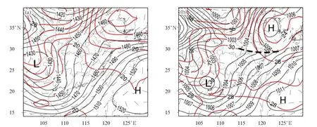
Fig.2.(a)Geopotential height(m;dark solid lines)and temperature(℃;red lines)at 850 hPa and(b)isobars(hPa; dark solid lines),temperature(℃;red lines),and the convergence line(thick dashed line)at the surface.

Fig.3.Distributions of the brightness temperatures(TBBs;shaded in℃)at the cloud tops observed from the FY2E satellite at(a)0600 UTC,(b)0700 UTC,(c)0800 UTC,and(d)1000 UTC 24 June 2013.The thick dashed line indicates the surface convergence line.JX:Jiaxing;HZ:Hangzhou;SX:Shaoxing;NB:Ningbo;HZB:Hangzhou Bay.
A new WCL developed into an independent convective cell that extended westward from the northern part of the bay while the clouds in the southern part of the bay propagated eastward.Two hours later,at 1000 UTC,the clouds continued extending westward to the northern part of Hangzhou City and the Hangzhou Bay(Fig.3d).The clouds to the south of the bay persistently moved eastward,and were not affected by the convective clouds developing to the north of the bay.
Analysis of the satellite TBBs showed that the WCL first formed to the north of the Hangzhou Bay,
and produced a short torrential rainfall event(Fig. 4).The convective clouds then moved westward to Linping(the northern part of Hangzhou City),where they also produced heavy rainfall.The rainfall mostly occurred in Jiaxing,Tongxiang,and Linping.The 12-h cumulative rain amount was greater than 100 mm, and more than 150 mm occurred in Linping.The surface rainfall data shown in Fig.4 were obtained from 322 automatic weather stations.
The time series of the 10-min cumulative rainfall measurements made at Linping,Xingqiao,and Desheng weather stations shown in Fig.5 was used to analyze the development and movement of the rain clouds over the northern part of Hangzhou City.Heavy rainfall of more than 70 mm at 1 h occurred in Linping at 0900 UTC(Fig.5a).Xingqiao station(Fig.5b) is 5 km southwest of Linping(Fig.4),and the peak rainfall occurred at about the same time at both stations.The peak rainfall times in different places were used to estimate the horizontal scale of the convective cell.The rainfall peak moved southwestward,reaching Gongchenqiao 40 min after it had occurred at Linping and Xingqiao(Fig.5c).Heavy rainfall of more than 107 mm at 1 h occurred in Desheng at 1100 UTC. Desheng is 20 km from Linping,indicating that the convection cell moved southwestward at less than 10 km h−1.
The large-scale systems in the upper troposphere moved eastward(see Fig.3)but the strong convective cells that formed in the northern part of the Hangzhou Bay propagated southwestward against the movement of large-scale circulations in the upper troposphere. The rainfall system was small,moving less than 100 km and lasting for only about 4 h,but the torrential rainfall caused severe damage.Further analysis of the data at a higher resolution was required to determine the nature of the system that moved against the prevailing upper-level westerly circulations of the Meiyu front.
4.Mesoscale observational analysis
4.1Temporal and spatial distribution ofthe mesoscale surface winds
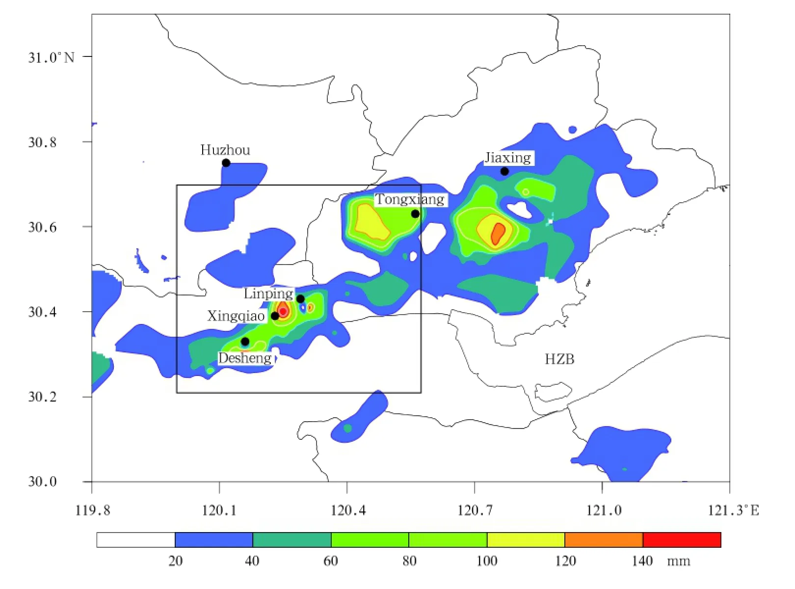
Fig.4.Horizontal distribution of the 4-h cumulative rainfall(mm)observed by 322 automatic weather stations between 0800 and 1200 UTC 24 June 2013.The rectangular box in the figure indicaties the area covered by Fig.1.HZB: Hangzhou Bay.

Fig. 5. Time series of the 10-min cumulative rainfall (mm)at stations in northern Hangzhou.(a)Linping,(b) Xingjiao,(c)Gongchenjiao,and(d)Desheng.
The WCL shown in the satellite image acquired at 0700 UTC(Fig.3b)was a key system in the torrential rainfall event.The formation of the WCL was closely associated with the circulations that occurred in the lower troposphere.Surface wind measurements made at automatic weather stations every 10 min were analyzed to allow mesoscale systems in the lower troposphere to be detected(see Fig.1).
The surface air motions that occurred before the torrential rainfall are shown in Fig.6.The WCL occurred over the northern part of the Hangzhou Bay at 2 h before heavy rainfall began as shown in Fig. 3b.As depicted in Fig.6a,the surface confluence occurred at the same time,near Tongxiang,Linping, and Desheng.This northeast-southwest surface confluence was collocated with the WCL.Thus,the convergence line is intimately associated with the formation of the WCL.The convergence line was associated with the northeasterly flows of the Yellow Sea high (see the surface high around 35°N,123°E in Fig.2b) and the southeasterly flows that occurred in the lower troposphere over the Hangzhou Bay.It is interesting to note that Linping was a confluence point because of the re-curvature of surface flows.
A meso-γ vortex formed at the surface near Linping weather station half an hour later.Northeasterly flows strengthened in Tongxiang at 0800 UTC(Fig. 6b),and this was associated with rainfall-enhanced surface divergence.This increased the surface divergence downstream(see Fig.7).Divergent flows came from the areas in Tongxiang where rainfall occurred and the temperatures were low,and the 10-min cumulative rainfalls in these areas were greater than 10 mm (solid lines in Fig.6b).The areas in which rainfall occurred also had low surface temperature and high surface moisture(figure omitted;relative humidity was over 85%).The surface temperature decreased and the surface moisture increased in Tongxiang,as shown by comparing Fig.6b with Fig.6a.The surface convergence line and the area of high temperatures shrank to the west.It should be noted that northerly winds were replaced with southerly winds(Figs.6a and 6b).The winds were weak but displayed a cyclonic circulation. This local wind change occurred half an hour before the rainfall event,and the winds remained unchanged in Linping.
Analysis of the winds(Fig.6b)clearly showed the presence of a meso-γ vortex of 10–20 km on horizontal scale.Analysis of the 10-min surface data showed that the meso-γ vortex lasted for about 40 min and was
was located in the areas with higher surface temperature and relatively lower relative humidity(less than 75%).Rainfall in Linping started 20 min later.Torrential rainfall in Linping started 40 min later,and the 10-min cumulative rainfall was greater than 20 mm(shown by the solid line in Fig.6b).The 1-h cumulative rainfall was greater than 70 mm.The vortex and convergence line over the northern part of Hangzhou City disappeared at this time and were replaced by prevailing northeasterly flows.Downdrafts associated with rainfall turned the rotational flows into divergence,pushing the convergence line southwestward to the western part of Hangzhou City,leading to a major torrential rainfall event there 1 h later. The isolated mesoscale area of heavy rainfall moved westward because the convergence line maintained,as shown in Fig.6,in particular,because of the existence of the meso-γ vortex.Compared to Jiaxing, the northern Hangzhou experienced enhanced rainfall due to the mesoscale vortex associated with confluence of surface flows in Linping.The convective cell was small because the vortex was small,as determined from the torrential rainfall area being 10 km across (from the observations made at the stations that were 5 km apart).

Fig.6.Surface wind stream line,surface temperature(℃;shaded),10-min cumulative rainfall(thin solid lines;at intervals of 5 mm starting at 1 mm),and surface convergence(thick dashed line)at(a)0700 UTC,(b)0800 UTC,and (c)0850 UTC.(d)The stream lines averaged between 0700 and 0820 UTC and the 80-min cumulative rainfall(mm; colored background).Station name abbreviations are the same as in Fig.1.
The surface winds over the northern part of Hangzhou City before the torrential rainfall occurred were analyzed based on a composite of the surface
winds from 9 sets of observational data for the period 0700–0820 UTC(Fig.6d).Confluence occurred over Hangzhou,and the convergence line in Fig.6d was similar to the convergence line in Fig.6a.The average surface wind field showed that there was a half-vortexlike circulation over the northern to western parts of Hangzhou City,and,in particular,over Linping.This suggests that the vortex lasted for a specific period of time and had a particular strength.The convergence line extended to the northern part of Jiaxing and became wide in that area.Rain fell mainly over central Jiaxing for 80 min before the torrential rainfall occurred.The orientation and location of the rainband was consistent with the WCL observed in the satellite image acquired at 0700 UTC.The peak 80 min cumulative rainfall was greater than 60 mm.Northeasterly surface flows from the area in which rainfall occurred and southeasterly flows from the Hangzhou Bay formed another mesoscale convergence line(thick dashed line in Fig.6d).The confluence from different convergence lines therefore occurred in Linping before the torrential rainfall occurred;this was one of the key factors involved in the formation of the vortex over the northern part of Hangzhou City.
The surface wind field described above showed that there was a relationship between the meso-γ vortex and the mesoscale convergence line.The surface dynamic factors 30 min before the torrential rainfall occurred in northern Hangzhou City were analyzed to elucidate the role of the surface mesoscale vortex (Fig.7).A well-defined meso-γ vortex was found,and this vortex was associated with convergence belts of–1.5×10⁻⁴s−1from northeasterly flow associated with the Yellow Sea high,easterly flow from the rainfall area,and southeasterly flow from the Hangzhou Bay (also see the dark dashed line in Fig.7,similar to those shown in Fig.6d).The convergence in the west of Linping was the weakest,indicating that relatively weak surface flows occurred there.But analysis of half-hourly data shows that a mean cyclonic vorticity center of over 3×10⁻⁴s−1was collocated with the meso-γ vortex over the Linping area,suggesting that both the cyclonic vorticity and the meso vortex formed before the torrential rainfall occurrence in Linping.
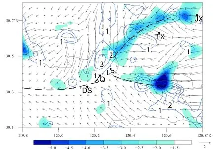
Fig.7.Surface wind vector,convergence(shaded;10−4s−1),and cyclonic vorticity(thin lines;at intervals of 10−4s−1) averaged between 0740 and 0810 UTC.Station name abbreviations are the same as in Fig.1.
Our analysis of the high-resolution surface observational data showed that the mesoscale convergence line and the disturbance vortex near the surface corresponded with the confluence of flows,producing convective clouds and rainfall.This could have been a result of the relationship between the vortex and convergence line over short periods and distances.
4.2 Spatial structure of the surface meso-γ vortex
The meso-γ vortex varied quickly and was small; as a result,the monitoring station network could not effectively detect the vortex signals.The sudden torrential rainfall and the sudden appearance of a surface convergence line in Linping were associated with disturbances in the meso-γ vortex.The data retrieved from the Doppler radar observations(Liu et al.,2003, Liu Liping et al.,2005,Liu Shuyuan et al.,2005)were used to analyze the spatial structures of the vortex. The retrieved wind data at heights of 1–3 km are shown in Fig.8.A meso-γ vortex appeared in Linping (Figs.6b and 7)before the torrential rainfall occurred at 0810 UTC.This vortex was first identified at 0720 UTC.The retrieved wind fields at 1-km height were used to detect the meso-γ vortex,and vortex circulation could clearly be identified at 0836 UTC.The meso-γ vortex was over Linping at 0842 UTC,and it was 10–20 km across(Fig.8b).The meso-γ vortex appeared half an hour later at 1 km than at the surface. The time that the vortex occurred at 1 km was similar to the time that the torrential rainfall occurred in Linping(see Fig.5a).The vortex moved ahead of the strong echo center(>40 dBZ)in the area in which the torrential rainfall occurred(the solid line CD in Fig. 8a).Strong northeasterly winds occurred east of the meso-γ vortex at 1 km,suggesting that the torrential rainfall led to easterly flows increasing over the northeastern part of Jiaxing.
The meso-γ vortex could clearly be identified from the radar-retrieved wind fields at 2 km at 0854 UTC (Fig.8b)when the surface rainfall reached a maximum(25 mm in 10 min).The radar-retrieved wind fields showed that cyclonic circulations occurred to the south of Linping,and the radar reflectivity reached 60 dBZ at the center of the meso-γ vortex and the area affected by torrential rainfall.There was a trough at 3-km height over the rain bands between Tongxiang and Linping(Fig.8c),i.e.,northeasterly flows with cyclonic circulations prevailing from northern Jiaxing to Linping and westerly or southwesterly flows prevailing over southern Jiaxing and the northern part of the Hangzhou Bay,forming a northeast-southwest cyclonic shear.A meso-γ vortex appeared over southern Tongxiang,whereas a vortex did not fully form over Linping.The shear line in the lower troposphere between Jiaxing and Linping was collocated with the surface shear line,indicating that there was a mesoscale trough in the lower troposphere.
The analysis described above showed that the meso-γ vortex formed later in the lower troposphere than at the surface,but the meso-γ vortex in the lower troposphere was in-phase with the torrential rainfall that occurred at the surface.The rainfall at 0800 UTC and heavy rainfall at 0820 UTC in Linping are shown in Fig.4b.The rainfall rate increased dramatically at 0830 UTC,while the meso-γ vortex started and lasted for half an hour(determined from the radar-retrieval data.).The 10-min cumulative rainfall in Linping at that time was greater than 15 mm(Fig.8a),and this occurred when the meso-γ vortex formed at 1 km. The sudden occurrence of torrential rainfall in Linping(see Fig.5)led to the meso-γ vortex occurring later than the surface rainfall started,but the mesoγ vortex appeared when torrential rainfall occurred. Convergence occurred in the lower troposphere during the Meiyu,and the flows from different directions resulted in the mesoscale vortex forming at the surface. This mesoscale vortex at the surface was a key factor triggering convection.

Fig.8.Retrieved wind vector fields at heights of 1–3 km for 24 June.The radar-retrieved wind(arrows),radar echo (shading),and 10-min cumulative rainfall(dashed lines at intervals of 5 mm starting at 1 mm)are shown at(a)1 km at 0842 UTC,(b)2 km at 0854 UTC,and(c)3 km at 0854 UTC.The▲marker indicates the radar location,and the thick dashed line in(c)indicates the shear line.
There may have been uncertainties in the retrieved Doppler radar data.We therefore aimed to determine how closely the wind fields shown in Fig.8 matched the observations.To achieve this,the radial winds retrieved from the radar data were compared with the wind observations made by using a wind profiler.The profiler and the radar were at the same site (marked as▲in Fig.8).The evolution of the wind fields observed by the profiler between 0800 and 0900
UTC at Hangzhou city is shown in Fig.9.This period was slightly before the period shown in Fig.8, but analyzing this period allowed the winds in the lower troposphere to be assessed.Easterly winds occurred in the planetary boundary layer(below 1 km), and the wind speeds were 1–4 m s−1.A saddle wind pattern was found around Hangzhou radar station,as shown in Fig.8a.The winds turned into southwesterly with speeds less than 10 m s−1above 1.5 km(Fig. 9).A comparison of the retrieved winds at 2–3 km shown in Figs.8b and 8c revealed that the prevailing winds were westerly,consistent with the profiler observations.This suggests that the retrieved wind data and the profiler observations agreed fairly well. The winds observed by the profiler(Fig.9)were westerly or northwesterly in the upper troposphere.The radar-retrieved winds rotated clockwise as the height increased before the torrential rainfall occurred,showing that warm advection occurred in the atmosphere. In particular,the wind direction mainly changed in the lower troposphere,indicating that strong winddirection shear occurred in the lower troposphere.
4.3 Clouds and circulation associated with the meso-γ vortex
Evolution of the divergence and vorticity in the centers of the vortices at surface and in the lower troposphere are shown in Fig.10.It should be noted that the x-axis indicates time,starting from the left, which is the opposite of the axis used in Fig.5.A convergence of–10−4s−1appeared around the vortex center before and at the time the surface vortex formed at 0820 UTC.The surface convergence was associated with cyclonic vorticity(shown as the red dashed line in Fig.10).Rain started to fall after 0820 UTC and peaked at around 0900 UTC.The surface rainfall increased gradually,but the surface winds became divergent and the surface cyclonic vorticity began to weaken.Analysis of the vorticity at 1-km height,calculated from the radar data,revealed that the cyclonic vorticity tendency significantly increased after the meso-vortex appeared in the lower troposphere at 0830 UTC(shown as the blue dashed line in Fig.10).The increase in cyclone vorticity occurred at the same time as the increase in rainfall occurred. Convergence in the lower troposphere(shown as the blue solid line in Fig.10)was at–5×10⁻⁴s−1.Convergence and cyclonic vorticity decreased rapidly as the rainfall weakened.The collocation of the vortex
centers at the surface and in the lower troposphere indicates that the development of the vortex enhanced convergence and the cyclonic vorticity.
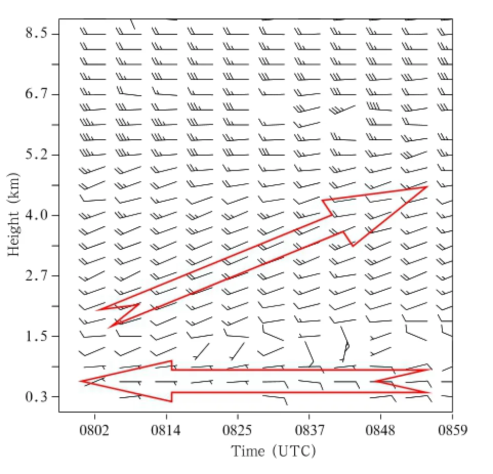
Fig.9.Observed wind for 0800–0900 UTC,acquired by a radar wind profiler in Hangzhou city.
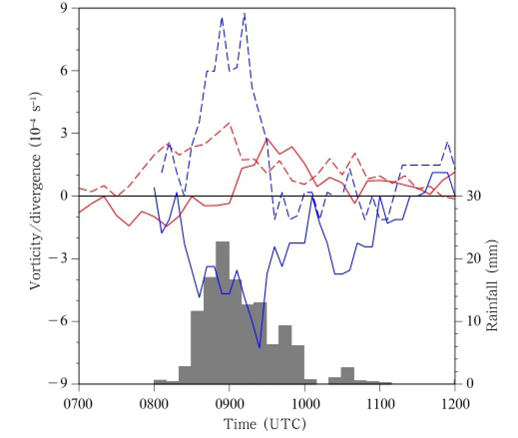
Fig.10.Time series of the divergence(solid lines),vorticity(dashed lines),and rainfall(black bars)in the center of the vortex at the surface(red)and at 1-km height(blue). Rainfall was observed at the Linping weather station.The units are 10−4s−1for divergence and vorticity(left axis) and mm for hourly rainfall(right axis).
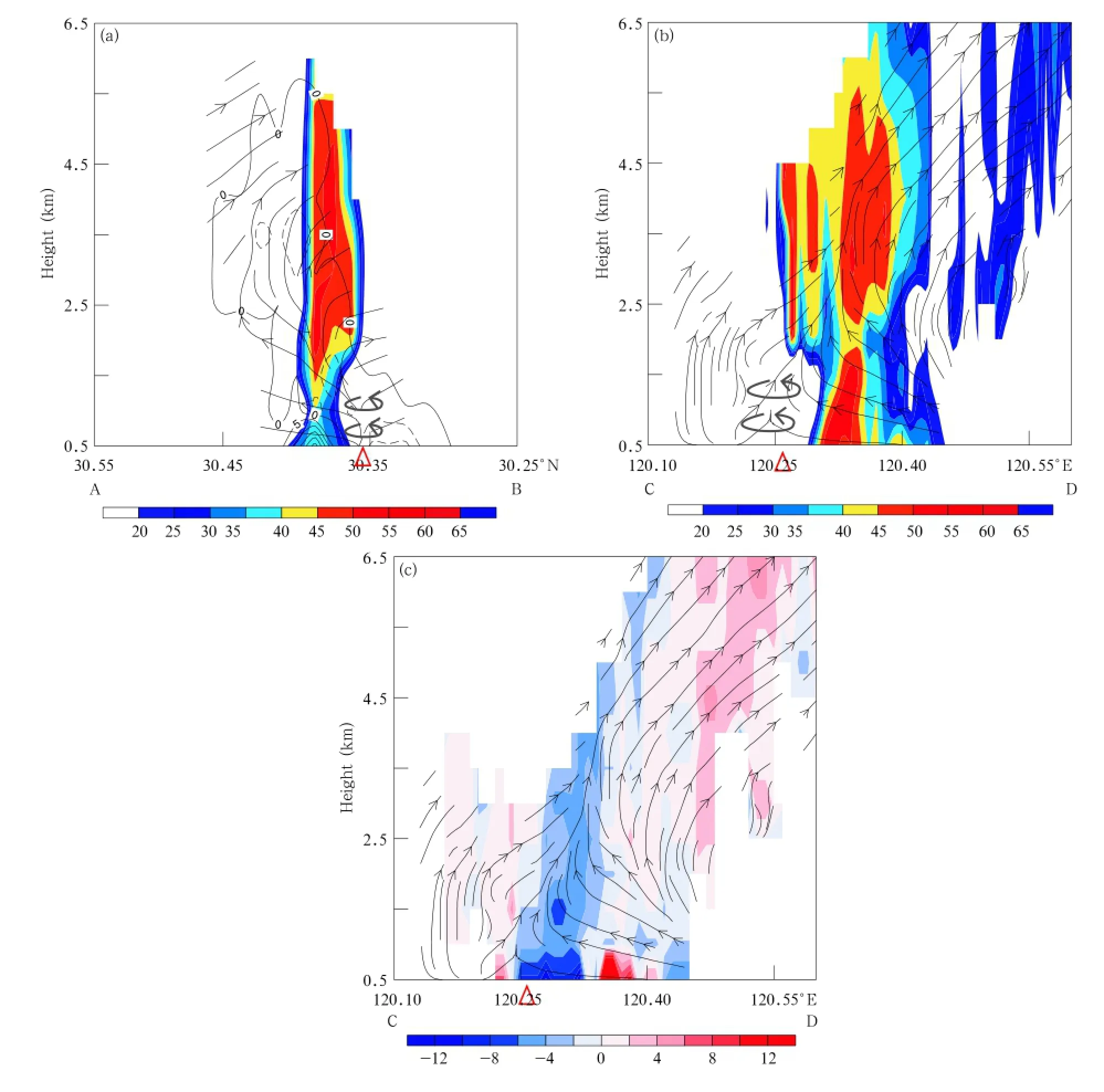
Fig.11.Longitude-height cross-sections of(a)perpendicular and(b)parallel to the convection direction(also see lines AB and CD in Fig.8a).The vectors are vertical circulations retrieved from radar data.The red triangles indicate a height of 1 km,and the thick cyclonic circulation symbols indicate vortices at the surface and at 1-km height.The contours in(a)indicate divergence(10−4s−1).The colored backgrounds in(a)and(b)indicate the radar reflectivity, and in(c)indicate the divergence.
Analysis of the radar retrieval data showed that the mesoscale cyclonic circulation developed well in the planetary boundary layer.Cross-sections along the lines AB and CD in Fig.8a are plotted in Fig. 11 to study the spatial structure of the mesoscale circulation.The meso-vortex(red triangle)was located at the southern end of the strong convective echo,as shown in Fig.11a.Convergence(dashed contour in Fig.11a)tilted northward as the height increased and crossed the strong echo region.The tilted updrafts from south of the strong convection area and from the
surface(at 500 m)crossed the lower-tropospheric vortex and strong echo area,forming a weak echo region (WER)without a boundary south of the strong echo column.Strong convergence occurred from south of the boundary layer,whereas strong divergence(the solid line in Fig.11)occurred in the boundary layer beneath strong convection where rainfall occurred. Convergence was dominant in the boundary layer to the west of the lower-tropospheric radar echo column, as shown in Fig.11c.Lower-tropospheric convergence crossed the WER upward with a tilt.A narrow divergence zone in the boundary layer appeared beneath the echo column.The meso-vortex(the triangle in Fig. 11c)was to the west of the strong echo column and ahead of the movement of the convective clouds.The convergence-induced upward motions tilted,crossing the lower-tropospheric meso-vortex to reach the convective clouds through the WER.The strong upward motion mainly corresponded with convergence.
Analysis of the relationship between the echo structure and the meso-vortex in Linping revealed that the echo structure was a group of convective clouds typically associated with Meiyu heavy rainfall but also similar to clouds that occur in multi-cell storms when strong convection develops(Lemon,1977,1980). The bounded WER caused by strong tilted upward motions had medium and lower-level echo walls,weak echo regions,and a hanging echo.The radar data were not available at higher levels,so high-level radar echo structures could not be analyzed in this study.
The lower tropospheric meso-vortex reached its maximum extent in the same area as the convergence and positive vorticity centers occurred,as shown in Fig.11.Chisholm and Renick(1972)and Lemon (1980)found that a meso-vortex occurred in a mature supercell storm.The meso-vortex in that case first formed in the midtroposphere,then developed upward and downward.Yu et al.(2006)analyzed several storms in China and showed that supercell storms could occur in China.It can be seen from Fig.11 that the meso-vortex was associated with the center of upward motion during the period when strong convective clouds were developing,and this would have enhanced the growth of the convective clouds.This led to the vertical structure of the clouds having a WER,as that in supercell storms.The rainfall rate increased to reach its peak after the meso-vortex had formed(see Fig.5a).This indicates that the formation and development of the meso-vortex favored the growth of convective clouds and led to the short torrential rainfall event occurring in Linping.Our analysis of this case study showed that the meso-vortex that was detected by radar occurred mainly in the boundary layer.
Torrential rainfall took place along a surface convergence line in Linping during the Meiyu period.This convergence line was caused by flows coming from different directions. The cyclonic disturbances formed over the surface convergence line(Figs. 6d and 7),leading to surface cyclonic vorticity increasing and convergence strengthening,and therefore to convection and the associated clouds developing. The occurrence of the meso-vortex strengthened the growth of the convective clouds,triggering the formation of the meso-vortex in the lower troposphere. The meso-vortex appeared to the west of the convective clouds because the northeast-southwest oriented clouds formed a physical barrier(Figs.11b and 11c). The northeasterly flows were caused by circulations to the west of the cloud barrier.The meso-vortex increased the upward motion,producing the torrential rainfall.
5.Conclusions
A torrential rainfall event that happened over the northern part of Hangzhou Bay in June 2013 was analyzed to assess the mechanisms involved in the formation and triggering of the event.The event was found to have involved the westward propagation of upper-tropospheric circulations,to have occurred over a small area and over a short period,but the heavy rainfall was a major local disaster.The major conclusions of this study are summarized below.
(1)A weak and short convective cloud line over the northern part of Hangzhou Bay formed because of a mesoscale convergence line near the surface.The convergence line and weak convective cloud line were
collocated and had similar orientations. The convergence line formed because of the confluence of northeasterly and southeasterly flows.The convective rainfall appeared over the convergence line,which caused the surface convergence and downstream confluence of the flows from different directions.This led to the formation of a meso-γ vortex;then,the meso-γ vortex moved westward,which led to the rainfall moving westward.
(2)The meso-γ vortex was 10–20 km across.The vortex lasted about 1 h when the surface circulation was stable.The vortex formed over a warm surface with air temperature of about 30℃ and relative humidity of less than 75%.The meso-γ vortex favored the formation and development of mesoscale convection.The torrential rainfall event occurred after the meso-vortex in the same area.The isolated surface meso-vortex led to a dramatic increase in the rain amount that fell over northern Hangzhou city,including Linping and Desheng.The small horizontal size of the vortex meant that the convective cloud was narrow and the disaster area was small.The disturbance vortex easily formed over the surface convergence line and the vortex triggered convection.Analysis of the vertical structures of the circulations showed that the meso-γ vortex appeared later in the lower troposphere than at the surface,but the meso-γ vortex in the lower troposphere was in-phase with the torrential rainfall that occurred at the surface.
(3)Analysis of the radar echo and radar-retrieved wind fields revealed that the meso-γ vortex in the lower troposphere formed to the south of the strong radar echo and torrential rainfall.Convergence near the surface led to cyclonic circulation in the lower troposphere enhancing upward motions that occurred at angles other than vertical.Strong upward motions led to convective cloud echo structures,similar to WERs in severe storms.Such echo structures are favorable for enhancing convection.In the Linping event that was analyzed in this study,the torrential rainfall was caused by the convergence line,the meso-γ vortex near the surface,and the cold downdrafts induced by the upstream torrential rainfall.
Acknowledgments.The authors thank the Hangzhou WeatherBureau for providing nonconventional observation data,Dr.Liu Liping at the State Key Laboratory of Severe Weather for providing radar retrieval data,and two anonymous reviewers for their constructive comments.
Che Junhui,Zhao Kun,and Diao Xiuguang,2013:Analysis of mesoscale vortex signatures in a heavy rainfall event.Periodical of Ocean University of China,43, 17–24.(in Chinese)
Chisholm,A.J.,and J.H.Renick,1972:The kinematics of multicell and supercell Alberta hailstorms, Alberta Hail Studies,1972. Research Council of Alberta Hail Studies Rep.No.72–2,24–31.
Crook,N.A.,and J.Z.Sun,2002:Assimilating radar, surface,and profiler data for the Sydney 2000 Forecast Demonstration Project.J.Atmos.Oceanic Tech.,19,888–898.
Ding Yihui,1993:Persistent Severe Rainstorms over the Yangtze-Huaihe River Basin in 1991.China Meteorological Press,Beijing,255 pp.(in Chinese)
Gao Shouting,Zhao Sixiong,Zhou Xiaoping,et al., 2003:Progress of research on sub-synoptic scale and mesoscale torrential rain systems.Chinese J. Atmos.Sci.,27,618–627.(in Chinese)
Jiang Yongqiang,and Wang Yuan,2012:Numerical simulation on the formation of mesoscale vortex in col field.Acta Meteor.Sinica,26,112–128.
Jiang Yongqiang,Wang Yuan,L¨u Mei,et al.,2013:Analysis on the impact of deformation field on a heavy rainfall event over southern China in middle and late June of 2010.Scientia Meteor.Sinica,33,168–177. (in Chinese)
Lemon,L.R.,1977:Severe thunderstorm evolution:Its use in a new technique for radar warnings.Preprints, 10th Conf.on Severe Local Storms,Boston,Amer., Meteor.Soc.,77–80.
Lemon,L.R.,1980:Severe thunderstorm radar identification techniques and warning criteria.NOAA Tech.Memo.NWS NSSFC-3,Kansas City,National Severe Storms Forecast Center,60 pp.
Liao Yishan,Li Jun,Wang Xiaofang,et al.,2010:A meso-β scale analysis of the torrential rain event in Jinan on 18 July 2007.Acta Meteor.Sinica,68, 944–956.(in Chinese)
Liu Liping,Zhang Peiyuan,Liang Haihe,et al.,2003: Error estimation in wind fields derived from dualdoppler radar and data quality control. J.Appl. Meteor.Sci.,14,17–29.(in Chinese)
Liu Liping,Mo Yueqin,Sha Xuesong,et al.,2005:Radar data processing and a variational algorithm for three-dimensional wind field retrieval by C-band bistatic radar network.Chinese J.Atmos.Sci.,29, 986–996.(in Chinese)
Liu Shuyuan,Liu Liping,Zheng Yongguang,et al.,2005: Tests for VAP algorithm of retrieving wind from single Doppler radar data.Acta Scicentiarum Naturalum Universitis Pekinesis,41,163-171.(in Chinese)
Lu Er,Ding Yinghui,M.Murakami,et al.,1997:Nature of precipitation and activity of cumulus convection during the 1991 Meiyu season.Acta Meteor.Sinica, 55,318–333.(in Chinese)
Ni Yunqi and Zhou Xiuji,2004:Study for formation mechanism of heavy rainfall within the Meiyu front along the middle and downstream of Yangtze River and theories and methods of their detection and prediction.Acta Meteor.Sinica,62,647–662.(in Chinese)
Ni Yunqi,Liu Liping,Gao Mei,et al.,2004:The Field Scientific Experiments of Heavy Rainfall within the Meiyu Front in the Middle and Lower Reaches of the Changjiang River.China Meteorological Press, Beijing,210 pp.
Shen Hangfeng,Zhai Guoqing,Zhu Ye,et al.,2012:Numerical study of a mesoscale vortex in the planetary boundary layer of the Meiyu front.Acta Meteor. Sinica,26,788–802.
Shen Hangfeng,Zhai Guoqing,Yin Jinfang,et al.,2013: Feature analysis of mesoscale vortex over lower reaches of Yangtze River during Meiyu period.Chinese J.Atmos.Sci.,37,923–932.(in Chinese)
Sun,J.Z.,and N.A.Crook,1997:Dynamical and microphysical retrieval from Doppler radar observations using a cloud model and its adjoint.Part I:Model development and simulated data experiments.J.Atmos.Sci.,54,1642–1661.
Sun,J.Z.,and N.A.Crook,2001:Real-time low-level wind and temperature analysis using single WSR-88D data.Wea.Forecasting,16,117–132.
Tanamachi,R.L.,L.J.Wicker,D.C.Dowell,et al., 2013a:EnKF assimilation of high-resolution,mobile Doppler radar data of the 4 May 2007 Greensburg, Kansas,supercell into a numerical cloud model. Mon.Wea.Rev.,141,625–648.
Tanamachi,R.L.,H.B.Bluestein,M.Xue,et al.,2013b: Near-surface vortex structure in a tornado and in a sub-tornado-strength convective-storm vortex observed by a mobile,W-band radar during VORTEX2.Mon.Wea.Rev.,141,3661–3690.
Tao Siyan,Ni Yunqi,Zhao Sixiong,et al.,2001:The Study on Formation Mechanisms and Forecasting of Heavy Rainfall in the Summer 1998.China Meteorological Press,Beijing,184 pp.(in Chinese)
Tao Shiyan,Zhang Xiaoling,and Zhang Shunli,2004: The Study on Heavy Rainfall Disasters on Meiyu Front in the Yangtze River.China Meteorological Press,Beijing,113 pp.
Wang Xiaofang,Cui Chunguang,Cui Wenjun,et al., 2014:Modes of mesoscale convective system organization during Meiyu season over the Yangtze River Basin.J.Meteor.Res.,28,111–126.
Wang Zhi,Zhai Guoqing,and Gao Kun,2003:Analysis and numerical simulation of a meso-β-scale vortex in the middle reaches of the Yangtze River.Acta Meteor.Sinica,61,66–77.(in Chinese)
Yu Xiaoding,Xiao Xiuping,Xiong Yannan,et al.,2006: Doppler Radar and Its Operational Applications. China Meteorological Press,Beijing,314 pp.
Zhai Guoqing,Wang Zhi,and He Bin,2003:Formation and evolution analysis of the mesoscale vortex group in the middle and lower reaches during Meiyu of the Yangtze River.Acta Meteor.Sinica,61,661–672. (in Chinese)
Zhai Guoqing,Zhou Lingli,and Wang Zhi,2007:Analysis of a group of weak small-scale vortexes in the planetary boundary layer in the Meiyu front.Adv. Atmos.Sci.,24,399–408.
Zhang Xiaoling,Tao Siyan,and Zhang Shunli,2004: Three types of heavy rainstorms associated with the Meiyu front.Chinese J.Atmos.Sci.,28,187–205. (in Chinese)
Zhang Xiaoling,Jiao Meiyan,and Chen Tao,2010: Mesoscale analysis of a heavy rainfall event along the Huaihe River valley during 8–9 July 2007.Acta Meteor.Sinica,24,365–379.
Zhao Sixiong,Tao Zuyu,Sun Jianhua,et al.,2004:Study on the Mechanism of Formation and Development of Heavy Rainfall on Meiyu Front in the Yangtze River.China Meteorological Press,Beijing,281 pp. (in Chinese)
Zheng Yongjun,Wu Guoxiong,and Liu Yimin,2013:Dynamical and thermal problems in vortex development and movement.Part I:A PV-Q view.Acta Meteor.Sinica,27,1–14.
:Zhai Guoqing,Zhang Honglei,Shen Hangfeng,et al.,2015:Role of a meso-γ vortex on Meiyu torrential rainfall over the Hangzhou Bay,China:An observational study.J.Meteor.Res.,29(6), 966–980,
10.1007/s13351-015-5029-3.
Supported by the National Natural Science Foundation of China(41175047 and 41475039)and National(Key)Basic Research and Development(973)Program of China(2013CB430104 and 2015CB953601).
∗Corresponding author:xiaofanli@zju.edu.cn.
©The Chinese Meteorological Society and Springer-Verlag Berlin Heidelberg 2015
(Received March 13,2015;in final form Octorber 30,2015)
 Journal of Meteorological Research2015年6期
- Journal of Meteorological Research的其它文章
- Advances in Research on Atmospheric Energy Propagation and the Interactions between Different Latitudes
- Uncertainty in the 2℃Warming Threshold Related to Climate Sensitivity and Climate Feedback
- Asymmetric Features for Two Types of ENSO
- ENSO-Independent Contemporaneous Variations of Anomalous Circulations in the Northern and Southern Hemispheres:The Polar-Tropical Seesaw Mode
- Seasonal Inhomogeneity of Soot Particles over the Central Indo-Gangetic Plains,India:Influence of Meteorology
- Effect of Urbanization on the Urban Meteorology and Air Pollution in Hangzhou
