
Evaluation on water resources carrying capacity of Changchun-Jilin Region
2015-12-12 03:12:48YUEChenCUIYaliRAORongDONGXiang
地下水科学与工程(英文版) 2015年2期
YUE Chen, CUI Ya-li, RAO Rong, DONG Xiang
1Institute of Hydrogeology and Environmental Geology, CAGS, Shijiazhuang 05006, China.
2School of Water Resources and Environment, China University of Geosciences (Beijing), Beijing 100083, China.
3School of Architecture, Tsinghua University, Beijing 100084, China.
Abstract: Based on such principles as sustainable development and ecological cycle, this paper evaluates the water resources carrying capacity (WCC) of Changchun-Jilin region using a population-economy-water resources correlation evaluation model built on the basis of WCC evaluation method as elaborated in the methodology of Functional Zoning of Population Development. Results show that the annual WCC of Changchun-Jilin region is able to support the population there, as a basic balance is struck between population and water resources. The incorporation of WCC into overall urban planning is one of the building blocks for sustainable city development with an advisable size.
Keywords: Water resources carrying capacity; Changchun-Jilin region; Population-economywater resources correlation evaluation model
Introduction
The 21thcentury has witnessed the global reach of the issues of water resources shortage and water pollution. At present, the UN and other international institutions concerned have made both effective supply and highly efficient utilization of freshwater as important signs of economic, social,scientific and technological development of a country or a region. Therefore, WCC, the basis on which major issues such as sustainable development and water safety are secured, deserves extensive attentions and study.
The study of WCC overseas traces its origin back to the 1970s, though with little special research and was mainly as part of the sustainable development theory. China began its own study in this area in the middle-to-late 1980s, and up until now, focused on the natural and social attributes of water resources, namely, the natural features of regions or drainage basins and economic and social development, aimed at solving problems with existing methods that fully respect the principle of sustainable development. However, a systematic research system is yet to be established (Yue C et al. 2012; SHI Jun-ping and YANG Yan, 2010; LU Qi et al. 2013).
This paper evaluates the WCC of Changchun-Jilin region using a populationeconomy-water resources correlation evaluation model built on the basis of WCC evaluation method as elaborated in the methodology of Functional Zoning of Population Development.The aim of doing so is to discover the WCC factors that significantly influence the development of Jilin Province as well as the extent of such influence. Also, it aims to incorporate WCC into overall urban planning to help explore an advisable size for sustainable city development (YUE Chen et al. 2014; JIANG Tian-yu, 2015).
1 Research method
1.1 Water resources loading capacity index (C)
Water resources loading capacity index (C), a main indicator for the potential of water resources to be exploited, can be expressed through the population size and economic scale of a certain region supported by its water resources, reflecting the relationship between water resources and population and economic growth of a certain region (KE Li-dan, 2006; LIU Xiao-ping, 2008;PAN Xing-yao, 2006).

Where, C- water resources loading capacity index;
P- population (10×103people)
G- GDP (10×109yuan)
W- total amount of water resources (1×10⁹m3);
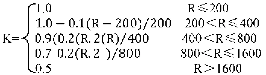
K- rainfall-related coefficient, and its value changes in line with the following calculation formula, where R refers to the annual rainfall measured in millimeter.
In the order of the value of water resources loading capacity index, different regions of Jilin Province can be categorized into six levels in terms of the exploitation potential of water resources, the meaning of each level listed on Table 1.
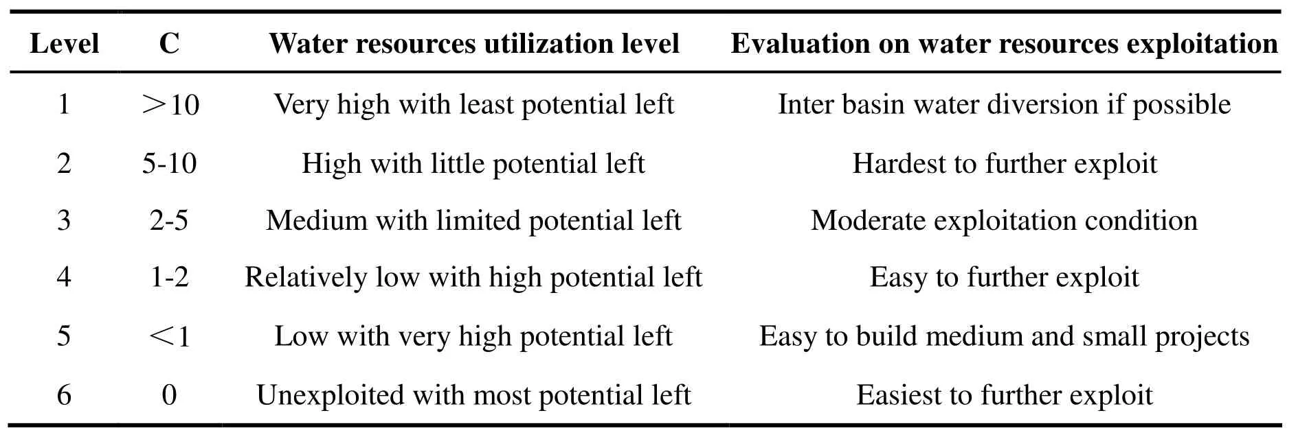
Table 1 Water resources loading capacity index classification and meaning
As the reflection of the relationship between population and water resources of a certain region,WCC could represent the population size or density (km2) supported by the water resources of that region through per capita comprehensive water consumption.
Where, WCC-water resources carrying capacity per 10 000 people;
W-available water resources (m3);
Wpc- per capita comprehensive water consumption (m3per person).
1.3 Water resources carrying capacity index (WCCI)
WCCI refers to the ratio of population size (or population density) to WCC (or carrying capacity density) of a certain region and reflects the relationship between that water resources and population of that region.

Where, WCCI-water resources carrying capacity index;
WCC- water resources carrying capacity;
Pa- population;
Rp- water resources overload ratio;
Rw- water resources surplus ratio.
Based on WCCI and with three-tier classification of water resources as the basic unit,different regions in Jilin Province can be classified into three types in terms of water-population balance-overloaded region, balanced region and surplus region:

Table 2 WCCI-based WCC evaluation
(1) Overloaded region-WCCI is greater than 1.33, which means the overload rate exceeds 50%.There is a severe shortage of water resources,falling far short of the needs of population and making inter basin water diversion a must-do.
(2) Balanced region-WCCI falls between 0.67 and 1.33, an overall water-population balance,which means water is able or barely able to meet the demand. We should base economic and social development on WCC and weigh population expansion and economic and social growth against water resources.
(3) Surplus region-WCCI is lower than 0.67,which means surplus rate is over 30%. Water supply is able to support further economic growth and population expansion.
2 WCC evaluations on central Jilin Province
2.1 Overview on natural and geographical features of study area
The study area is Changchun-Jilin region,including the cities of Changchun, Dehui, Jiutai and Jilin, and the counties of Nong’an and Yongji.As the region is in the north temperate continental monsoon climate zone, rainfalls in different parts and time vary hugely. Its annual average rainfall over the years is 600 mm, 70%-80% of which falls in summer between June and September. The region is home to three major rivers: The Second Songhua River and its tributaries of Yinma River and the East Liaohe River.
2.2 General information of the study area
The region’s water supply mainly relies on the Second Songhua River and its tributaries and largely goes to irrigation and industrial water consumption, with the former accounting for 49.83% and the latter 34.49%. An analysis of the economic growth and population size of each part reveals that Changchun is more populous and advanced economically while Jilin, in addition to its large area of farm land, places great importance to the heavily water-consuming second industry.With this in mind, we have the relationship of water and population and economy in this region as follows.
Water resources loading capacity index (C) is shown in Table 4 and substitute K value in Table 4 into the above calculation formula to get C.
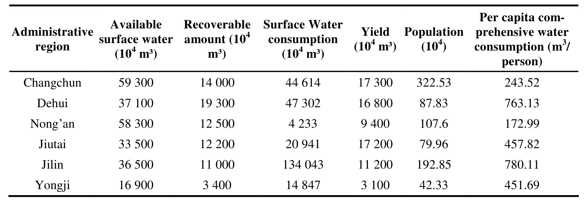
Table 3 General information of Changchun-Jilin region 2009
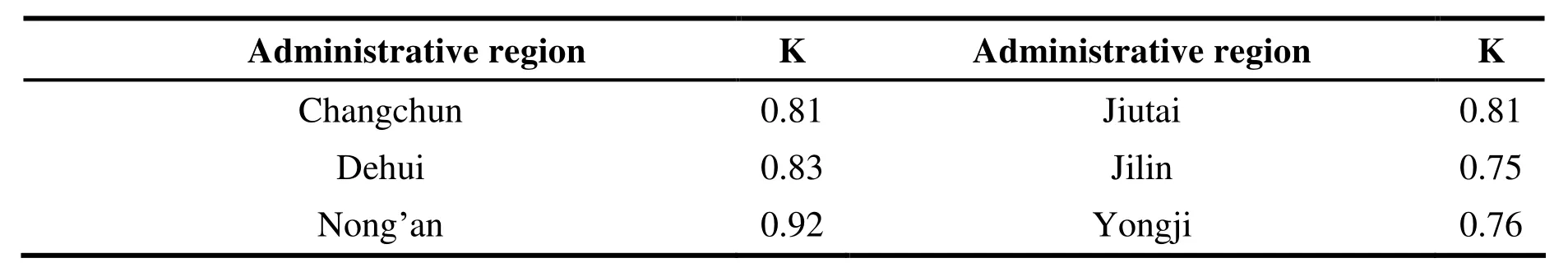
Table 4 K value of different regions

Table 5 Water resources loading capacity index (C)

Table 6 Water resources carrying capacity (WCC)Unit: 10 000
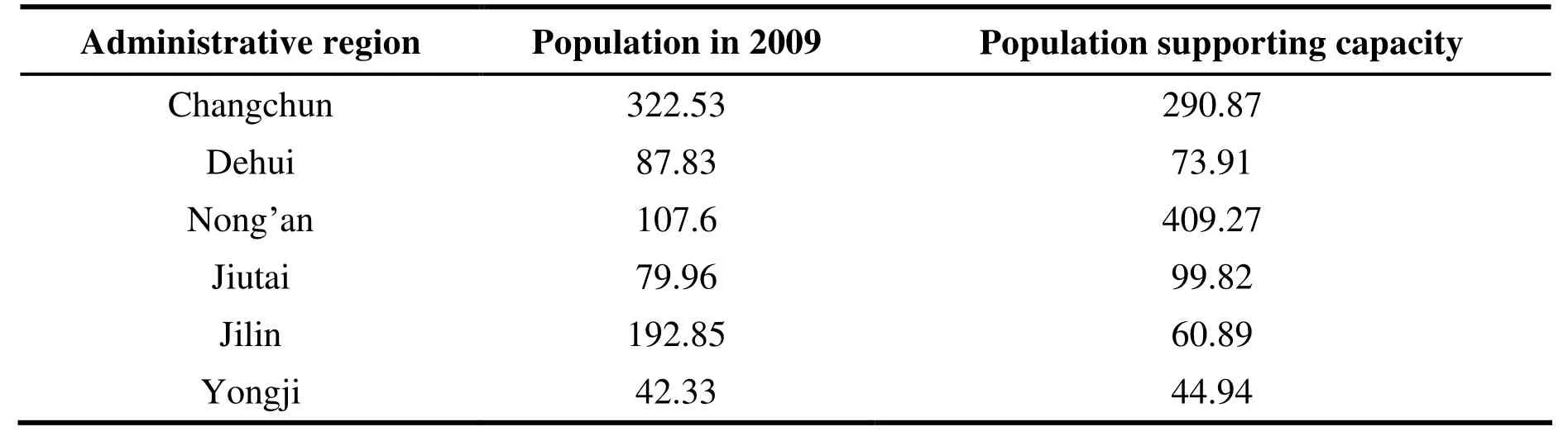
Table 7 Could-support-population VS actual-support-population Unit: 10 000
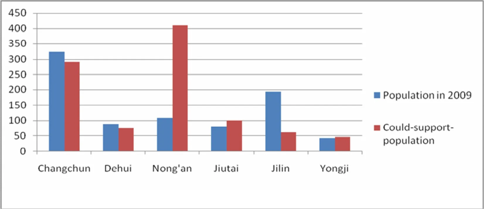
Fig.1 Actual population of this region in 2009 VS the population it could support (10 000 people)
Evaluation on C
From Table 5, we can see that the C value in all parts is greater than 10, a sign of a very high utilization level of water resources that makes it necessary to divert water from the outside, especially Changchun and Jilin where the value is higher than 10.
Water resources carrying capacity (WCC)
After getting WCC from the formula, we can compare the population it could support with the number it actually supports to conclude the current state of water-population balance as shown in Table 6 and Table 7.
From Table 7, we can see that the WCC of Changchun still has room for slight population growth while that of Jilin has not because the actual population has outgrown the number the WCC could support.
3 Discussions
Discussion on the state of water resources in different parts of Changchun-Jilin Region based on the 2009 water resources potential index and WCCI:
(1) Changchun: Its WCCI sits around 1, so the WCC, which is in a state of threshold overcapacity instead of balance, is unable to support its actual population. From the perspective of water reserve,Changchun’s relatively small rainfall thanks to its location in water-deficit central Jilin Province doesn’t help much in raising the reservoir level.Changchun’s large population compounds the water issue when its advanced economy already stretches industrial water use. A major agricultural county, Nong’an County is blessed with relatively abundant rainfall, which goes mainly to agriculture,thus it has richer water reserve than others to be further exploited.
(2) Jilin: WCC of Jilin is in a state of heavy overcapacity, falling short of the need of actual population. From the perspective of water reserve,Jilin City has a large reserve due to the many rivers flowing through it,though it is also located in water-lacking area of Jilin Province. The city’s industries, however, are big water-consumers. Worse still, its enormous population-the second largest in Jilin Province-also imposes great pressure on domestic water use. While the agricultural county Yongji is in a balanced population-water state thanks to its abundant surface water.
Conclusion
This paper evaluates WCC of Changchun-Jilin Region using WCCI based on the economypopulation-water resources evaluation model.Results show that, on the whole, the annual WCC of this region is now in a state of population-water balance thus can support the population there.Water resources deserve high attention in overall urban planning to help set an advisable city scale that respects WCC.
Acknowledgements
Fund Project: The research and demonstration of key technologies and methods of eco-planning in urban construction, the 11thFive-year Plan of National Science and Technology Infrastructure Program, MOST, 2007-2011 (No. 2007BAC28 B02).
- 地下水科学与工程(英文版)的其它文章
- Analysis of the negative effects of groundwater exploitation on geological environment in Asia
- Specific yield of phreatic variation zone in karst aquifer with the method of water level analysis
- Application of remote sensing technique to mapping of the map series of karst geology in China and Southeast Asia
- Compilation of Groundwater Quality Map and study of hydrogeochemical characteristics of groundwater in Asia
- Comparison of 1,2,3-Trichloropropane reduction and oxidation by nanoscale zero-valent iron, zinc and activated persulfate
- Governance of protected areas: Kara Kara National Park, Victoria