
Study on the Extraction of Vegetation in Mineralized Alteration Zone based on the ETM+ Image
2015-01-12 03:38:01JinsongCHENChunmeiFANXingmeiDAIErruiPENG
Jinsong CHEN,Chunmei FAN,Xingmei DAI,Errui PENG
College of Water Conservancy,Yunnan Agricultural University,Kunming 650201,China
Study on the Extraction of Vegetation in Mineralized Alteration Zone based on the ETM+ Image
Jinsong CHEN*,Chunmei FAN,Xingmei DAI,Errui PENG
College of Water Conservancy,Yunnan Agricultural University,Kunming 650201,China
Vegetation is an important element and has such a complexity and uncertainty in remote sensing image that the extraction of vegetation by using remote sensing is a very difficult work.Vegetation is extracted using rich ETM+data in mineralized alteration zone of west Tianshan,Xinjiang to subsequently extract the minerals alteration.In order to ensure better minerals alteration,the feature-oriented principal component analysis+optimal density segmentation was proposed based on the analysis of spectral feature of vegetation and minerals alteration.The results showed that using ETM+band 3 and band 4 combinations can better extract vegetation and this method is of great value in use.
Remote sensing;Vegetation;ETM+;Principal Component Analysis(PCA)
R emote sensing is the acquisition of information about objects on Earth and much progress has been made on both of acquired information and information processing since the first launched landsat satellite by the US in the 1970s.What’s more,it is also one of early researched contents to explore plants on Earth by remote sensing, providing rich experience.
Although remote sensing takes advantages in investigating land vegetation,the extraction on vegetation information with remote sensing is confronted by new challenges upon research objectives.The research studied on the extraction of vegetation in mineralized alternation zone based on the ETM+data,aiming at further extracting the minerals alteration.In the extraction process,however,vegetation,as an interference factor,has significant effects on extraction of mineralized alteration.Furthermore,imaging of vegetation tends to be volatile upon season and type,so that a spectrallibrary of vegetation is unavailable still now.The research,therefore,is of great value for avoiding interference from vegetation in extraction of mineralized alteration.
Research Regions
The research region,at84°40′E-85°E,43°05′N-43°30′N,is located in neighboring areas of Chagannur Iron Deposit,165 km away from Hejing County(310°),in the middle ofwestern Tianshan,Xinjiang Uyghur Autunomous Region.It is a moderatehigh mountainous area and altitude is in the range of between 2 248-4 286 m.In general,the land is high in the north and descends to the south and relative altitudes are of 600-1 200 m. Additionally,mountain slopes are high of 20°-40°and the region with altitude below 2 900 m is dominated by alpine meadow.Bed rocks are widely distributed in mountain tops and ridges under severe weathering;talus materials are mainly on slopes and the vegetation is very dense at the bottom of the mountains.As shown in Fig.1, Chagannur Iron Deposit is situated inthe northwest of a crater,and volcanic edifice develops well,especially for ultramafic complex,with favorable geologicalconditions for minerals.According to geological surveys available, mineralized alterations are extensively distributed in the research region[1-2]. Generally speaking,the research region is widely covered by vegetations.
Image data
The research used ETM+multispectrum remote sensing images on August 7,2000,because with glacier melting,rocks would be exposed as much as possible.However,it is notable that it is also the phase when vegetation grows exuberantly.With radiation correction,atmospheric correction and geometric correction of data,multi-spectra wave bands,including bands 1,2,3,4,5 and 7 were chosen,with resolution ratios at30 m, and bands 6 and 8 were abandoned, considering extraction of mineralized alteration in the next phase.In addition,Universal Transverse Mercator (UTM)Projection was used and geometric space meets the demands of precision.
Information extraction
Theory
The remote sensing information is extracted based on geological model,quantitative or qualitative,to establish data mapping relation corresponding to objectives and derive physical quantity,recognized target and spatial distribution of target objects[3].In order to extract vegetation information with remote sensing and maintain mineralized alteration information in a maximized way,it is necessary to explore corresponding characters and establish geological models,quantitative or qualitative,for recognizing vegetation and the spatial locations.
It is researched that a healthy plant would weakly reflect green wave of visible lights and highly reflect red wave[4],which corresponds to the 2nd, 3rdand 4thwave bands of ETM+remote sensing data.Furthermore,the 5thand 7thwave bands would be weakly reflected also,butthe former proves stronger.It can be concluded that at extracting information with TM/ETM+ remote sensing data,only OH-alteration anomaly or reddish an-omaly of iron can be detected and the minerals containing OH-are of high reflection rate on the 5thwave band and would absorb lights on the 7thwave band.As for the minerals containing iron ion absorb lights of the 1stand 2ndbands and the absorption performs dramatic of the 3rdband,with a reflection peak[5].
Methods
For traditionalextractions of vegetation information,vegetation index method is popular,and of extractions of mineralized alteration,the method of Zhang’s[6]is quite successful,namely,principal component analysis (PCA)and threshold method.Therefore,on basis of analysis of vegetation and mineralized alteration,PCA and optimal density segmentation(to strengthen and extract information) were used in the research,with consideration of final objective and successfulexperience.At the very beginning ofstrengthening information,PCA was used for information extraction, but different waveband groups were chosen in accordance with spectral characters ofinformation.At extracting information,threshold method was used based on random distribution of reinforced alteration information in remote-sensing images,which coincided with normaldistribution.As for optimal density segmentation,it mainly divides images as per Fishe Discriminant. Specifically,although the sum ofdeviation within segments reaches the minimum,the sum of deviation among segments maintains maximum.Meanwhile,the segmentation points can be determined in a quantitative way to further divide object types to extract vegetation information[7],in order to extract the information and wellconserve mineralized alteration information as well.
As shown in Table 1,the correlation among data of wavebands 1,2 and 3 reached significant level,and wavebands 5 and 7 showed significant correlation as well,which indicated that information redundancy exists among the data.Furthermore,the variance of band 3 proved hiher,incorporating that the band contained more information.According to research of Loughlin,specific information can be accumulated into single principalcomponents by PCA[8]and principalcom-ponent analysis was conducted on bands 1-5 and 7,bands 1-4 and bands 3 and 4 on basis of analysis above(Table 2-Table 4).
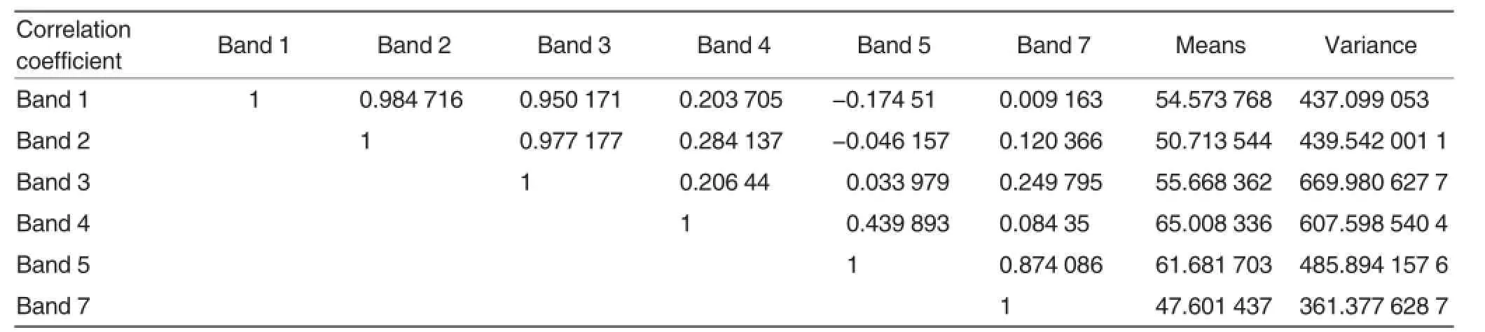
Table 1 Statistical results of ETM+data in research area
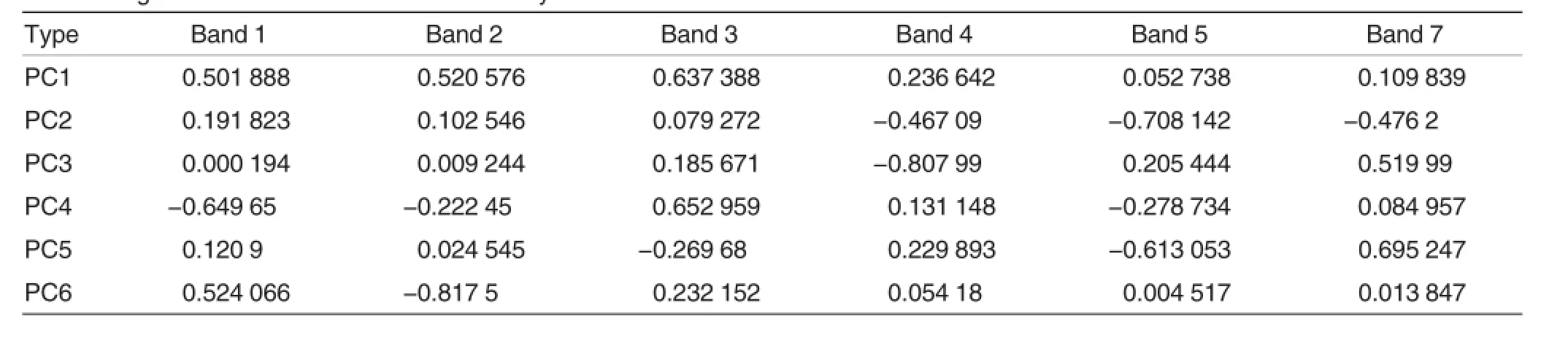
Table 2 Eigenvector matrix of band 1-5 and 7 by PCA
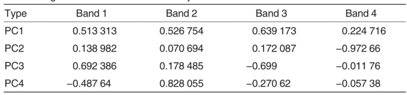
Table 3 Eigenvector matrix of band 1-4 by PCA
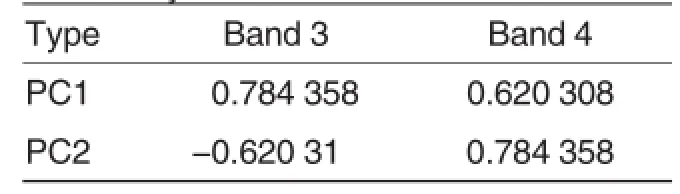
Table 4 Eigenvector matrix of band 3 and 4 by PCA
As shown in Table 2,according to PCA ofbands 1-5 and 7,ofthe principalcomponents,band 4 made maximal contribution of PC3 by reducing information,and the rest allby increasing information.In Table 3,based on PCA,PC2 reflected reducing information of band 4.As for PCA of bands 3 and 4,it suggested that band 4 made contribution by increasing information and band 3 decreasing information.
It is clear that for extraction of mineralized alteration information, band group of 1,3-5 and band group of 1,4,5,and 7 are commonly used for extracting information about OH-and reddish iron,respectively,and the 4thband is required to make small contribution.Therefore,images of-PC3 from PCA on bands 1-5 and 7,-PC2 from PCA on bands 1-4,and PC2 from PCA ofbands 3-4,were used as characteristic images for vegetation information extraction.And optimal density segmentation was used for obtaining optimal thresholds,which were computed at 24.0649,34.2992 and 24.4515(Fig.2-Fig.4).
Results and Analysis
The research was mainly conducted based on alpine meadow and few tall pines in low-altitude regions, so that vegetations seem limited and single.In order to verify the conclusions,some pixel dots of vegetation and mineralized alteration samples, which have been determined.Specifically,198 vegetation dots and 55 mineralized alteration dots were chosen. As shown in Table 5,most vegetation information can be extracted from the research region of three PCA groups, with mineralized alteration information maintained.For the 1stgroup,allmultispectral band information was used. Although the accuracy of extracted information reached as high as 88.38%,it can be concluded that some glacier information was contained,because glacier reflected of the 4thband and absorbed lights of the 3rdband.The 2ndgroup used some spectral band information and the accuracy reached 80.8%.Nevertheless,the images showed that some vegetation information was omitted.As for the 3rdgroup,with little band information,two bands representing spectral characters were selected as per specific demands and the statistics indicated that the accuracy performed the best at 92.93%.What’s more,the extraction avoided interferences from glacier information and maintained allalteration information.
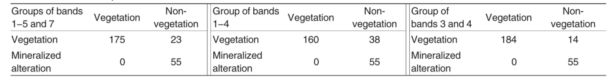
Table 5 Results ofsample statistic test
Conclusions
Principal component analysis is generally used to compress data and remove correlation,which is used in the research to extract information oriented by specific objective,on basis of recognition of vegetation and mineralized alteration spectralcharacters,and the extracted information is ofhigh reliability,providing references for information extraction of vegetation in similar areas.
[1]FENG JS(冯金石),SHIFP(石福品), WANG BY(汪邦耀),etal.Volcanogenic iron deposit on awulale metallogenic beltin western Tianshan Mountains(西天山阿吾拉勒成矿带火山岩型铁矿)[M]. Beijing:Geology Press(北京:地质出版社),2010.
[2]WANG BY(汪邦耀).Geologicalcharacteristics and genesis of chagangnuoer and Zhibo volcanogenic iron deposit,in western Tianshan,Xinjiang(新疆西天山查岗诺尔和智博火山岩型铁矿矿床地质特征㈦成因研究)[D].Xi’an:Chang’an University(西安:长安大学),2011.
[3]ZHOU CH(周成虎),LUO JC(骆剑承), LIU QS(刘庆生),et al.Geosciences understanding and analysis of remote sensing image(遥感影像地学理解㈦分析)[M].Beijing:Science Press(北京:科学出版社),1999.
[4]ZHAO YS(赵英时),CHEN DM(陈冬梅), YANG LM(杨立明),etal.Remote sensing application analysis principles and methods(遥感应⒚分析原理㈦方法)[M]. Beijing:Science Press(北京:科学出版社),2003.
[5]SU YM(苏一鸣),LIXQ(李向前),ZHU YF(朱叶飞).Application of ETM+(TM) anomaly extraction method of altered remote sensing in Nanjing to Zhenjiang region(ETM+(TM)蚀变遥感异常提取方法在宁镇地区的应⒚)[J].Journalof Geology(地质学刊),2009,33(1):84-88.
[6]ZHANG YJ(张Ⅰ君),ZENG CM(曾朝铭),CHEN W(陈薇).The methods for extraction of alteration anomalies from the ETM+(TM)data and their application:method selection and technological flow chart(ETM+(TM)蚀变遥感异常提取方法研究㈦应⒚——方法选择和技术流程)[J].Remote Sensing for Land&Resources(国土资源遥感),2003,2:44-49.
[7]WU DW(吴德文),ZHANG YF(张远飞), ZHU GC(朱谷昌).The best density separation method for extracting rock information from remote sensing image(遥感图像岩石信息提取的最优密度分割分割方法)[J].Remote Sensing for Land&Resources(国土资源遥感), 2002,4:51-54.
[8]LOUGHLIN WP,CCLORADO C.Principal component analysis for alteration mapping[C].Presented at the Eighth Thematic Conference on Geologic Remote Sensing.U.S.A.1991.April 29-May 2.
Responsible editor:Xiaoxue WANG
Responsible proofreader:Xiaoyan WU
基于ETM+影像的矿化蚀变区植被信息提取研究
陈劲松*,范春梅,代兴梅,彭尔瑞
(云南农业大学水利学院,云南昆明650201)
植被在遥感影像上成像具有复杂性和不确定性,这使得利⒚遥感技术提取植被信息具有很大的难度。利⒚数据资源丰富的ETM+影像数据对新疆西天山矿化蚀变区的植被进行提取研究,目的是为进行下一步的矿化蚀变信息提取做准备。为保证在提取植被信息后能较好地保留矿化蚀变信息,在认真分析了植被和矿化蚀变的光谱特征后,提出采⒚“面向特征的主分量分析+最优密度分割”法,最后得出采⒚ETM+波段3和波段4组合的方式能够取得较好的效果,该方法具有一定的适⒚性。
遥感;植被;ETM+;主成分分析
云南省教育厅科学研究基金项目(2014Y190)。
陈劲松(1973-),男,湖北钟祥人,博士研究生,讲师,主要从事多元地学信息技术方面的研究,E-mail:cjscom@126.com。*通讯作者。
2014-11-06
Supported by Scientific Research Fund for Departmentof Education of Yunnan Province (2014Y190).
*Corresponding author.E-mail:cjscom@126.com
Received:November6,2014 Accepted:December16,2014
修回日期2014-12-16
猜你喜欢
建材发展导向(2022年24期)2022-12-22 07:44:36
河北地质(2022年2期)2022-08-22 06:24:04
环境卫生工程(2021年4期)2021-10-13 06:52:26
现代园艺(2017年23期)2018-01-18 06:58:12
应用海洋学学报(2015年2期)2015-11-22 07:36:28
色谱(2015年6期)2015-04-08 06:03:51
丝绸(2014年5期)2014-02-28 14:55:12
丝绸(2014年3期)2014-02-28 14:54:52
河南科技(2014年4期)2014-02-27 14:07:25
全国新书目(2009年12期)2009-09-11 08:25:32
 Agricultural Science & Technology2015年1期
- Agricultural Science & Technology的其它文章
- Research Status and Application Prospects of Monascus sp.
- A Study on the Relationships of Ecological Civilization Construction with Natural Conservation and Sustainable Resources Use
- Inquiry of Modernization Managementof Rural Community Self-organizing on the Perspective of SocialWork
- Research Advances in Spatio-Temporal Coupling of Water and Fertilizer in Sugarcane
- Instrucions for Authors
- About Agricultural Science Technology