
Current climate change effects on the ground thermal regime in Central Yakutia
2014-12-15 05:55:26StepanVarlamovYuriSkachkovPavelSkryabin
Stepan Varlamov ,Yuri Skachkov,Pavel Skryabin
Melnikov Permafrost Institute,Siberian Branch of the Russian Academy of Sciences,Yakutsk 677010,Russia
1 Introduction
In the context of research into global climatic change,an interest in problems of permafrost response to these changes has increased.Research on the impact of climate warming on permafrost involves a wide variety of issues,including the thermal evolution of upper permafrost in natural and disturbed landscapes under anthropogenic effects.This research has become a priority in geocryological science,with theoretical and practical significance worldwide.
Study of the thermal state of upper permafrost in the context of climate change and industrial development is based on data of weather and geocryological stations,monitoring sites,regional and engineering projects.
Pioneering systematic observations of temperatures in 10–15 m depth bore holes were conducted in 1935.The study revealed peculiarities of temperature variations and ground thaw depth under the effects of vegetation and snow cover,"cultural layer",and geological and geo-morphological parameters (Melnikov,1950;Solov’ev,1959).In the 1940s,yearlong experimental observations were conducted to study ground temperature regime variations under thermal insulation,snow and vegetation cover removal,and in natural landscapes of experimental sites of the Yakut permafrost research station (Shimanovskii,1942;Gerasimov,1950;Efimov,1952).In the 1950s–1960s,more detailed integrated thermal physics observations of shallow soil formation thermal regime were performed applying updated methods at experimental sites of the North-Eastern department of the Permafrost Institute under the supervision of N.S.Ivanov(1963).
Local and regional characteristics of ground thermal regime evolution have been revealed in detail with the introduction of monitoring methods (e.g.,Are,1973;Gavrilova,1978).In the 1960s–1980s,regular observations of the thermal balance according to a significantly updated program were conducted at Yakutsk,Syrdakh,Zelenyi Lug and Chabyda stations(Pavlov,1975;1979;Skryabinet al.,1998;Varlamovet al.,2002).The research covered both natural and disturbed landscapes.Daily,seasonal and annual variations in the surface energy balance were studied in detail,and a series of new mathematical models of ground thawing and warming were elaborated.Also,hydrothermal parameters of frozen ground under the impact of agricultural and reclamation projects were studied at Khatassy,Khorobut,and Amga seasonal stations (Gavrilievet al.,1984;Ugarov and Mandarov,2000).In the 1990s,a regular experimental research project commenced within the framework of international projects "GEWEX-GAME","CREST","JST"jointly with Japanese and Dutch researchers at stations of Spasskaya Pad and Neleger.Based on that research,long-term temperature variations of upper permafrost,soil moisture,seasonal thaw depth,water-heat balance and carbon currents were studied (Fedorovet al.,2006).Currently,monitoring of ground thermal regime is being held at Chabyda and Yakutsk stations,as well as at several study sites at Ukechi,Umaibyt,Kerdyugen,and along the northern portion of the Tommot-Yakutsk Railroad.
Research results of ground thermal evolution within Russia,during the period from the III International Year of Geophysics (1957/59) to the IV International Polar Year (2007/08) were evaluated by Pavlov (2008).Romanovskyet al.(2010) assessed the thermal state of permafrost in Russia for the last 20–30 years,although Central Yakutia was not included in the survey.
Changes in the thermal state of near surface permafrost layers in Central Yakutia,in natural and disturbed landscapes for the last 30–40 years are presented in Varlamovet al.(2011,2012),Skachkovet al.(2011),Skryabin (2011),Skryabin and Varlamov(2012),and Varlamov and Skryabin (2013).
The major objective of this paper is to evaluate the spatial and temporal variability of the ground thermal state under current climatic changes.To this effect,the following goals were realized:route survey,selection of objects,organization of a system of observational networks,analysis of long-term data from weather stations,regular observations at monitoring sites and summarizing of obtained data.
2 Project statement and research methods
In the research area,more than a hundred environmental complexes with various vegetation,ground cover,and resultant permafrost conditions have been identified.In general,at low terraces of the Lena River,continuous permafrost over the area and in cross section is present.Middle terraces are characterized by occurrence of supraand intrapermafrost water-saturated taliks in high temperature permafrost.The characteristic feature of an elevated terrace is a distribution of polygonal wedge ice in argillo-arenaceous depositions.Fragmentary evolution of ice is noted within the slopes of the Prilenskoye Plateau.
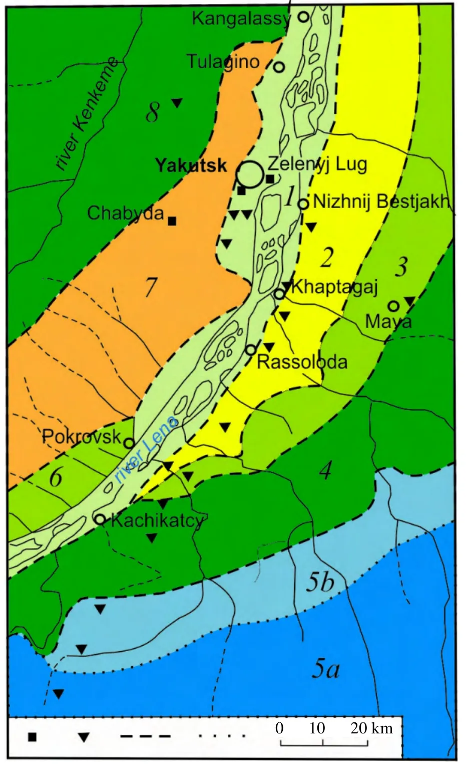
Figure 1 Map of study area.Squares represent stations;triangles represent sites;dash and dot lines represent borderlines of physiographic regions and sub-regions:1– Prilenskoye valley and forest-steppe;2– Bestyakhsky sand-ridge;3– Tyungyulyu alas-hollow;4– Lena-Amga alas-valley;5– Lena-Amga sandstone (sub-regions:a– sandstone,b– transitional polygenetic valleys);6– Prilenskoye east side small valley-alas;7– Prilenskoye east side sandstone;8– Kenkeme-Lensky small valley-alas.
Study of the ground thermal regime is performed by applying landscape and monitoring methods.Landscape study involves remote and ground-based sensing of landscape units,their classification,and mapping summary.The study results were used in selection of subjects and monitoring of the thermal state of upper permafrost.Monitoring sites were set up in six physiographic regions where nine terrain types and over 100 stows (elementary terrain elements) were identified (Figure 1).
Integrated observations at monitoring sites covered permafrost landscapes,cryogenic processes and phenomena,composition and structure of permafrost soils,ground temperature and moisture,volume weight and thawing,thermal conductivity of soil surface and ground,snow depth and density.
This study is focused on the lithogenic basis of permafrost landscapes,i.e.,upper permafrost within the depth of annual temperature variations (10–15 m).The main parameters which indicate dynamics of near-surface permafrost layers are:seasonally thawed layer thickness (ξ) and mean annual temperatures at the depth of zero seasonal amplitude (Tξ) and at the annual amplitude (T0).To register ground temperature,semi conductive thermal resistors MMT-4 was used,with an accuracy of 0.1 °C.To measure ground temperatures in boreholes,cables were used at 1,2,3,4,6,8 and 10 m depth.In boreholes,stationary cables were installed,i.e.,the holes were backfilled.The depth of seasonal thawing was defined by probing with a steel rod and by hand boring.Observation result analysis and summary at various monitoring stages are provided by Skryabinet al.(1998) and Varlamovet al.(2002).
3 Research results and discussion
3.1 Current climatic changes
Since the second half of the 1960s,according to Skachkov (2012),Central Yakutia has experienced the highest increasing trend in mean annual air temperature in northern Russia (up to 0.07 °C/a).In 2001–2013,the highest ever temperatures in the history of weather observations were registered in Yakutsk:-7.9 °C as compared with an average of-10.0 °C.Evaluation of predicted trends of temperature variations in the 21stcentury by various researchers is ambiguous.For example,predictions of climatic change performed by the Voeikov General Geophysical Observatory (GGO) based on climatic feature extrapolation results suggest that the observed increasing trend in Russian mean annual air temperature will be maintained by 2010–2015 and will increase by 0.6±0.2 °C,and 1.5 °C by 2030,as compared with year 2000 values.Further increase of mean amount of precipitation,predominately in the cold season is predicted.In the north of eastern Siberia,an increase of precipitation amounts by 7%–9% in winter,and of snow accumulation by 2%–4% is expected(FSHEM,2005).In the late 21stcentury in eastern Siberia,an increase of near surface mean annual air temperature is expected to be 6.1±1.6 °C,against the values of the last two decades of the 20thcentury(Meleshkoet al.,2008).Expected near surface mean annual air temperatures in Yakutsk up to 2015,as estimated at the Permafrost Institute of the Siberian Branch,Russian Academy of Sciences,applying the frequency analysis method almost coincides with the predictions made by GGO.Furthermore,a temperature decrease of 2–3 °C is expected up to the first half of the 21stcentury (Shenderet al.,1999;Romanovskyet al.,2007).According to predictions made by Neradovsky and Skachkov (2011),by 2050,an increase of mean annual air temperature will pass the achieved climatic level of no more than 0.7–1.0 °C.Researchers are more concerned about an expected increase of precipitation amounts in winter and snow accumulation playing a significant part in increase of soil temperatures.
3.2 Climatic effects on thermal regime of natural permafrost landscapes
Temperature monitoring conducted by the authors since the 1980s at seven physical-geographical regions of the west and east sides of the Lena River at the latitude of Yakutsk,allows us to identify the long-term dynamics in various natural landscapes (see figure 1).The value of long-term observations consists in formation of a database necessary for prediction of potential alterations in the state of permafrost with climatic warming.Observational sites were established in more than 100 stows in nine terrain types with various lithogenic substrates.The most detailed and long-term observations of ground temperature are conducted at Chabyda station 20 km southwest of Yakutsk by Lake Malaya Chabyda.The landscape is characterized by a combination of lowlands and highlands with rolling plains and ridges.Experimental sites were set up at two landscape types:small valley type–– on the bottom of a small valley (S-3a,S-8a and B-1) and bottom of a drainage depression(S-8);the slope type–– in a pine forest gentle slope(S-5 and S-6b),an interfluve (S-7b and S-9),a moderate north-facing slope (S-10),and a moderate south-facing slope (S-11).Within the Chabyda station area,seasonal thaw depth varies depending on landscape conditions from 0.37 to 4.11 m,while mean annual temperature at the thaw depth ranges between 0 and-7.4 °C,and at the depth of zero annual amplitude is within-0.2 and-4.9 °C.A wide range of variations of the thaw depth and ground temperature at the station allows us to refer the obtained patterns to the region as a whole.
Ground thermal state observations in 27–32-year cycles show that in the context of the significant increase of mean annual air temperature (Figure 2),seasonal thaw depth remains rather stable (Figure 3).Considerable inter-seasonal variations of thaw depth,along with a trend towards an increase of thaw depth are characteristic of small valleys,while in slopes,on the contrary,it decreases.In small valleys,a significant increase of the seasonal thaw depth was observed in 2002–2008.This was due to an increase of the water content in the active layer.In subsequent years,a rise of the permafrost table occurred due to large latent heat losses at the base of the active layer.
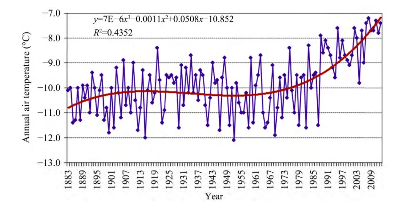
Figure 2 Variability of mean annual air temperature in Yakutsk.Bold red line:3rd order polynomial trend
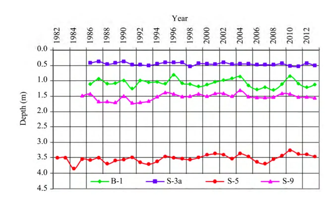
Figure 3 Dynamics of active layer thickness in various terrain types
In small valleys,long-term variability trends of the seasonal thaw depth vary from 0 to positive values (0.4 cm/a),while in slopes,negative trends (-0.15 to-1.9 cm/a) prevail.The only exception is south facing slopes(site 10),where a positive trend (0.6 cm/a) is noted.
It has been shown that from 1981/82 to 1998/99,a uniform interchangeability of low-snow and snowy winters,as well as a decrease of snow depth was observed.In 1999/00 and 2009/10,anomalously snowy and low-snow winters interchanged,and,correspondingly,early and late formations of stable snow cover were identified.The subsequent three winters were characterized by values close to long-term values of snow cover depth (Figure 4).
Major factors defining ground thermal regime dynamics are a thermal shielding role of snow cover,and patterns of its accumulation,notably,in early winter.Normally,the lowest surface temperatures form in low-snow years with anomalously late formation of stable snow cover.The maximal and minimalTξandT0,in reference to variations of soil parameters are noted with a 1–2 year delay,while at 10 m depth the delay lasts 1–3 years (see figures 4,5 and 6).During period of 2005–2007,winters were anomalously snowy and witnessed early dates of stable snow cover formation resulting in a sharp increase ofTξandT0,notably,at low-temperature complexes up to 6.0 and 2.7 °C.The winters of 2008/09 and 2009/10 were characterized as anomalously low snow with later than normal dates of stable snow cover formation and soils cooling down to the levels of 2002/03 (see figure 5).
In the course of observations,the lowest and highest soil temperatures were identified correspondingly in 2003/03 and 2006/07 (October–September)(Figures 5 and 6).The winter of 2002/03 was anomalously low-snow and it was set extremely late.This resulted in a fall of soil temperatures,though winter and summer seasons were anomalously warm.The following years were noted to be snowy,with spring floods and abundant autumn precipitation.From 2002/03 to 2006/07,the soil surface temperature in various landscape types increased by 0.5–6.0 °C and by 0.3–2.7 °C at the depth of zero annual amplitude.

Figure 4 Dynamics of mean snow depth in winter in various terrain types,Chabyda station

Figure 5 Variations of mean annual ground temperature at the base of the active layer in various terrain types
The winter of 2007/08 was low-snow,however,in the first half of the season it was low-snow with a late date of stable snow cover formation.These weather factors lead to a certain temperature decrease at the depth of seasonal thawing.Winters in 2008/09 and 2009/10 witnessed anomalous low snow and postponed dates of stable snow cover formation,which resulted in a sharp fall of temperatures at the depth of zero annual amplitude,despite anomalously warm weather.The following years were characterized by average values of winter snow depth close to the long-term mean,and that is why mean annual soil temperatures at the depth of seasonal thawing and of zero annual amplitude approached the long-term mean.It is worthwhile to note here that a correlational link between temperatures at the depth of seasonal thawing and average winter snow depth is rather high.The correlation coefficient is 0.55–0.74.
The major parameter changes of the soil thermal regime in each terrain type during the whole period of observations are summarized in table 1.
According to long-term observations,mean annual temperature trends at the depth of zero amplitude in various physical and geographical areas vary from negative to positive values.The temperature dependence on the composition and thermal type of seasonally thawed grounds is obvious (Table 2).Negative trends are observed in areas of warm soils where mean annul temperature of the active layer varies from positive to-1 °C.In the period of study,a positive trend of ground temperatures at the depth of zero annual amplitude prevailed,while the lowest trends were characteristic for terrain types with high temperature soils and the greatest depth of seasonal thawing.The highest trends are peculiar to landscapes with low ground temperature and,as a rule,with the lowest depths of seasonal thawing.Also,trend differentiation by the composition of seasonally thawed layers is observed.Long-term observations make it possible to state that variations ofT0are ambiguous,while a certain decrease of ground temperatures in some terrain types evidence their stability.

Figure 6 Variations of mean annual ground temperature at depth of zero annual amplitude in various terrain types
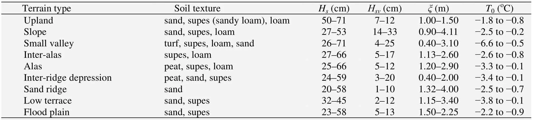
Table 1 Parameters of soil thermal regime in various terrain types

Table 2 Mean annual temperature trend of soils at the depth of zero annual amplitude (10 m depth)
3.3 Anthropogenic impacts on ground thermal regime
At present,assessment of upper permafrost evolution in terms of climatic change and anthropogenic impact is vitally important.In Central Yakutia,pipelines,railroads,highways,and transmission lines are being widely constructed,with resultant disturbance of natural conditions.Anthropogenic effects of various types and range,such as tree removal,fires,soil surface removal,lead to alterations in geocryological parameters,including the ground thermal regime and occurrence of negative cryogenic processes.Study of the ground thermal regime held by the authors since 1987 at the northern section of the Tommot-Yakutsk Railroad has provided qualitative evaluation of its spatial and temporal variability under technogenesis.
Experimental research allowed us to evaluate various anthropogenic impacts on the ground temperature in predominant terrain types.
Ground cover removal.In July 1990,in the interridge-depression terrain unit,0.15–0.25 m thick moss and peat layer was removed in a larch peat-moss bog forest.After two years,as compared with natural landscapes,soil surface removal resulted in an increase of ground mean annual temperature by 4 °C at 6 m depth,while the thickness of the seasonally thawed layer increased to 1.5 m.After 20 years,intensive overgrowth of the disturbed area with a young stand of dwarf birch lowered a difference of mean annual temperature to 1.8°C,while thickness of the seasonally thawed layer remained at the same level (1.4–1.5 m).
In 1992,in inter-alas terrains,deciduous trees were removed with subsequent disturbance of the soil surface with bulldozers and motorized vehicles for construction of the Nizhnyi Bestyakh–Mundulakh water pipeline.Eighteen years later,soil temperature at 10 m depth in the clear cut increased by 2 °C in comparison with that of natural landscapes,while the depth of seasonal thaw layer grew by 1.4 m and exceeded 3.0 m.These thermal changes caused surface subsidence of 0.6 m or more above ice wedges occurring at 2.0–2.5 m depths,resulting in polygonal relief.
In 1989,while constructing a lodging road at an inter-alas slope,the ground cover and surface were removed with bulldozers.Following heavy precipitation in June of 1990,thermal erosion began to occur along the road and resulted in ravine development.In five years,the ravine dimensions were as follows:length of 340 m,width of 10–16 m,depth up to 6 m.At the debris cone,alluvial soil of 0.5 m thickness formed,and in two years the trees died.Four years later,T0increased by 1.5 °C (Varlamovet al.,2002).Twenty years later,the debris cone overgrew with willows.In 2009,with thermometric sensors being damaged by workers,a geocryologically complicated profile was identified in boreholes drilled at the debris cone.The depth of seasonal thaw was 1.8 m.Within the depth interval of 3.4–3.8 and 4.2–5.5 m,thaw ground layers formed under the technical impact and alteration of soil-atmosphere thermal exchange parameters.
In 2005,research was conducted at an experimental site in ice-rich permafrost terrain,where ice-rich soils and ice wedges occur close to the surface,at depths of 0.6–1.2 m and 1.8–2.3 m,respectively.The surface and vegetation cover was removed at the center of the site.Trees along the site periphery were cut to simulate right-of-way clearing (Figure 7).

Figure 7 General view of the experimental site
In 2010,the ground subsided 29 cm at the center of the site.On the surface with removed tree stand,subsidence has stabilized at the level of 15 cm since 2008.
The thaw depth in the area with removed surface and vegetation cover reached its maximum in the fourth year and then stabilized (Figure 8).It increased 2.8 times compared to the undisturbed forest,extending down to the top of wedge ice.A stabilization process of long-term ice thawing is predetermined by intensive growth of herb cover (Figure 7).At tree-free sites (similar to cutting) thaw depth was insignificant,and two years later reached 1.60 m.Four years later,a decreasing trend of seasonally thawed layer depth was observed.In 2009,soil temperatures increased at sites with removed surface and vegetation cover at 4,6 and 10 m depth,by 1.2,1.3 and 0.7 °C respectively,against the data of 2005.A marked increase of ground temperatures was observed in seasonally thawed layers(Figure 8).In warm and low-snow winter periods of the last two years,the frozen layer did not link up with permafrost grounds.
Soil removal implies the most obvious alteration of the ground thermal regime in inter-alas terrain types,where the increase ofT0and growthξare calculated,correspondingly,to be within 1.5–2.0 °C and 0.5–1.8 m.At a disturbed site,thermal erosion is activated and polygonal terrains form.
Deforestation.Stand removal performed in various manners (selective,gradual,continuous) leads to alteration of permafrost conditions.In sand-ridge terrain types,tree removal effects on ground temperatures have been studied at seven assessment units.Continuous removal of pine trees results in a rise of the seasonal thaw depth by 0.8 m and a ground temperature increase by 0.4 °C at 10 m depth,as compared with natural terrains.The decrease ofT0by 0.9 °C and reduction ofξby 0.3 m have been noted at the old clear-cut,where a larch and pine forest is being restored.
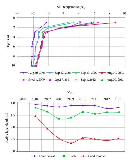
Figure 8 Alterations of the seasonal thaw depth and ground temperature at the experimental site.Site 1:surface with natural vegetation (larch forest);Site 2:surface with removed vegetation cover (cutting down);Site 3:surface with soil (10–20 cm thick) and vegetation cover
Selective dismantling of a larch forest in inter-alas terrains brings about an insignificant increase of the ground temperature by 0.2–0.4 °C due to tree removal held in the period with a stable snow cover,i.e.,with preservation of heat-proof effects of red bilberry and moss layers and intensive recovery of understory vegetation.
At sand ridges of inter-ridge-depression type terrains,selective tree removal and soil surface disturbance resulted in a ground temperature increase of 0.3–0.7 °C at 10 m depth over three year cycles.A marked increase ofТ0by 1.5–2.0 °C is observed 5–7 years after the post fire disturbance of a heat-proof moss and wild rosemary layer and partial fall of burnt trees.
Long-term borehole observations at sites B-56,B-57,B-187 and B-190 reveal variations of mean annual ground temperatures with differing regimes of tree removal.In sand-ridge type terrains,the ground thermal state in a 10–30 year-old understory grown in a clear-cut open pine forest is close to the pre-disturbance state.In inter-alas terrain,selective cutting of the larch-pine forest (B-187) at the birch-and-shrub stage(10–20 years) of leads to a 0.3–0.6 °C increase inТ0.Gradual removal of the larch forest (B-56) in the herb(3–8 years) and birch-and-shrub (10–20 years) stages causesТ0to increase by 0.5–1.2 °C.In the old cut(B-190) with 10–30 years old birch and larch understory,the averageТ0decreases by 1 °C.At this site,annual cycles (2005–2008) of warm winters and thick snow accumulation facilitated the increase ofТ0by 2.1 °C.The low-snow winters of 2009–2010 resulted in a decrease ofТ0(Figure 9).
Selective,gradual,and continuous deforestation in differing type terrains are combined with the growth ofT0by 0.2–0.8 °C and ofξby 0.3–0.6 m.
Forest fires.Forest types and surface layers in low terrace,inter-alas,and upland terrains are considered to be of high fire risk,sand-ridge terrains are of very high fire risk,and inter-ridge-depression areas of average fire risk.Pyrogenic influence on the thermal regime of soils has been thoroughly studied in ten assessment units.In June 1987,a fire in a pine forest killed the weak herb-bearberry layer and young pines.During two post-fire years,a rise (by 1.5 °C) of ground temperatures at 10 m depth was observed.After three years,at post-fire sites,ground temperature stabilization not exceeding-0.3 °C to-0.4 °C was observed with gradual re-initiation of birch-shrub growth.In 20 years,ξincreased by 1 m.
Post-fire areas and stand removal are well-known types of technogenesis.To assess effects of such disturbances on the ground thermal regime in low terrace areas,larch forest and post-fire areas were selected as assessment units where after the fire of 1986,burnt larch stand was removed.In one year,pyrogenic effects and deforestation causedT0to increase by 0.5 °C andξby 0.15 m,and in three years,correspondingly,by 0.8 °C and 0.43 m.Twenty years later,due to re-initiation of a birch and larch forest,T0decrease by 0.5 °C whileξincreased by 0.5 m in the post-fire area.
Alterations of the ground thermal state under disturbance also shows a decrease in ground temperatures predetermined by vegetation regeneration and its shading effects in other landscape types (Figure 10).
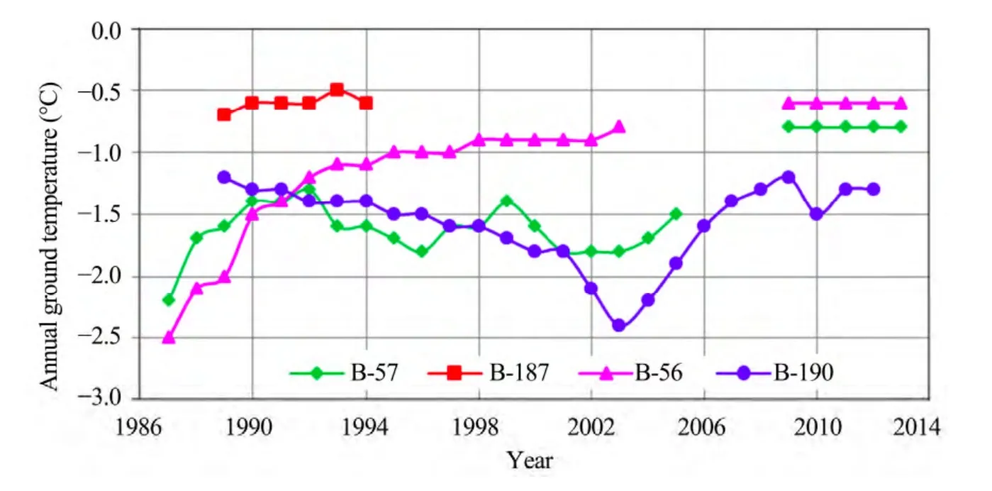
Figure 9 Mean annual ground temperature dynamics at 10 m depth in larch stand (B-57) with selective (B-187),gradual (B-56),and continuous (B-190) deforestation in inter-alas terrains
Temporary variability of the ground thermal state after the fire of 1986 and stand removal was studied in inter-alas terrains.Selective stand cutting with disturbance of surface layers after four post-fire years causedT0to increase by 0.3–0.5 °C.Furthermore,25-year long natural regeneration of the herb-moss cover and birch-larch thicket decreased exposure of ground surface to solar radiation and resulted in a gradual decrease ofT0by 1 °C (Figure 9) and ofξby 0.1–0.3 m.
Influence of wildfires on the thermal state of upland soils was studied in two post-fire areas,where larch and birch stand re-initiation is slow and an increase ofξby 0.3–0.4 m,and ofT0within 0.4–0.7 °C is preserved.Two to three years later after wildfires in sand-ridge terrains,T0increased by 1.0–1.5 °C with subsequent stabilization.
Pyrogenic effects and stand removal in low-terrace and inter-alas areas resulted in the 0.3–0.8 °C increase ofT0,and a growth ofξby 0.4–0.8 m after two years.In 15–20 years,with vegetation regeneration,T0drops by 0.5–0.7 °C.In inter-alas with close occurrence of underground ice,negative cryogenic processes are evident:transition from seasonal thawing to seasonal freezing.
Monitoring allows us to assess temporal variability of ground thermal regime in disturbed landscapes.The results obtained reflect alterations ofT0andξin natural and disturbed landscapes 5,10,20 and 25 years later.The aforementioned landscapes significantly differ in the ground thermal state.Variations of major thermal parameters during 25 years shows that the greatest temporal variability ofT0andξis noted in post-fire clearance of inter-alas terrain.

Figure 10 Variations of mean annual ground temperature at 10 m depth in pine forest (B-22) and on slash (B-13) in sand-ridge areas,in larch forest (B-210) and on a burn section (B-209) in inter-alas areas
4 Conclusions
1) During the last 30 years,the highest increasing trend of mean annual air temperature is observed in Central Yakutia.
2) In this context,seasonal thaw depth remains rather steady.
3) Long-term dynamics of the ground surface thermal state is relative stable.The thermal regime of low-temperature permafrost active layers is more open to impacts of short-term fluctuations of climatic factors,while that of high-temperature permafrost is less vulnerable.
4) The major regulatory factor of the steady thermal state of permafrost soils is snow accumulation.
5) Under disturbance of natural conditions (surface cover removal,stand removal,fires),the greatest alterations of the ground thermal state are identified in inter-alas terrains,where underground ice occurrence is close to the surface,and negative cryogenic processes develop such as sagging,ravine development,and erosion.
6) Application of the results of the study of ground thermal regimes in natural and disturbed terrains can be extended to similar types of landscapes in Central Yakutia.
Field work was supported from grants of the Siberian branch,Russian Academy of Sciences;the grant of the Russian Fund for Fundamental Research,project 01-05-96207 and projects (Nos.72,1.9.10,588,1090)by state order of the Sakha Republic (Yakutia).The authors express their gratitude for the financial aid for long-term field work.
Are FE,1973.Ground temperature regime beneath a draining thaw lake in Central Yakutia.In:Issues of the Geography of Yakutia.Gidrometeoizdat,Leningrad,pp.70–75.(in Russian)
Efimov AI,1952.Selected results of 3-year ground temperature observations in the Yakutsk area.In:Permafrost Investigations in the Yakut Republic,vol.3.USSR Acad.Sci.Press,Moscow,pp.8–19.(in Russian)
Federal Service for Hydrometeorology and Environmental Monitoring (Roshydromet) (FSHEM),2005.Strategic Prediction for the Period of up to 2010–2015 of Climate Change Expected in Russia and Its Impact on Sectors of the Russian National Economy.Moscow.
Fedorov AN,Maximov TKh,Gavriliev PP,et al.,2006.Spasskaya Pad:Integrated Investigations of the Permafrost Landscapes.Yakutsk.(in Russian)
Gavriliev PP,Mandarov AA,Ugarov IS,1984.Hydrothermal Reclamation of Agricultural Lands in Yakutia.Novosibirsk.(in Russian)
Gavrilova MK,1978.Climate and Perennial Freezing of Soils and Rocks.Novosibirsk.(in Russian)
Gerasimov NN,1950.Annual ground temperature variations in the Yakutsk area.In:Permafrost Investigations in the Yakut Republic.Yakutsk,pp.179–191.(in Russian)
Ivanov NS,1963.On the thermal regime of the upper earth crust in the Yakutsk area.In:Heat and Mass Exchange in Frozen Layers of the Earth Crust.USSR Acad.Sci.Press,Moscow,pp.9–55.(in Russian)
Meleshko VP,Kattsov VM,Govorkova VA,et al.,2008.Climate of Russia in the 21st century.Part 3.Future climate changes calculated with an ensemble of coupled atmosphere-ocean general circulation CMIP3 models.Russian Meteorology and Hydrology,33(9):541–552.
Melnikov PI,1950.Permafrost in the Yakutsk area.In:Permafrost Investigations in YaSSR,vol.2.USSR Acad.Sci.Press,Moscow-Leningrad,pp.52–70.(in Russian)
Neradovsky LG,Skachkov YuB,2011.Prediction of air temperatures in Yakutia up to 2050.In:Zhang RV (ed.).Permafrost Engineering,Proceedings of the IX International Symposium,3–7 September 2011,Mirny,Russia,Yakutsk,pp.389–393.(in Russian)
Pavlov AV,1975.Heat Exchange between Soil and Atmosphere in Northern and Temperate Latitudes of the USSR.Yakutsk.(in Russian)
Pavlov AV,1979.Thermal Physics of Landscapes.Novosibirsk.(in Russian)
Pavlov AV,2008.Permafrost Monitoring.Novosibirsk.(in Russian)
Romanovsky VE,Drozdov DS,Oberman NG,et al.,2010.Thermal state of permafrost in Russia.Permafrost and Periglacial Processes,21:136–155.
Romanovsky VE,Sazonova TS,Balobaev VT,et al.,2007.Past and recent changes in air and permafrost temperatures in eastern Siberia.Global and Planetary Change,56(3–4):399–413.
Shender NI,Romanovsky VE,Tetelbaum AS,1999.A forecast of the natural variability of climate in Yakutsk and Fairbanks.Nauka i Obrazovanie 2:24–29.(in Russian)
Shimanovskii SV,1942.Effect of pavements on the ground thermal regime.In:Permafrost Investigations in the Yakut Republic,vol.1.Yakutsk,pp.44–55.(in Russian)
Skachkov YuB,2012.Response of Central Yakutian permafrost to current climatic change.In:Proceedings of International Science Conference,17–21 September 2012,Irkutsk,vol.1,pp.236–238.(in Russian)
Skachkov YuB,Skryabin PN,Varlamov SP,2011.Near-surface ground temperature variations at the Yakutsk permafrost thermal monitoring site during the last 40 years.In:Zhang RV (ed.).Permafrost Engineering,Proceedings of the IX International Symposium,Yakutsk,pp.444–449.(in Russian)
Skryabin PN,2011.Post-disturbance changes in the ground thermal state along the northern section of the Tommot-Yakutsk railway.In:Zhang RV (ed.).Permafrost Engineering,Proceedings of the IX International Symposium,Yakutsk,pp.210–214.(in Russian)
Skryabin PN,Varlamov SP,Skachkov YuB,1998.Interannual Variability of the Ground Thermal Regime in the Yakutsk area.Novosibirsk.(in Russian)
Skryabin PN,Varlamov SP,2012.The Impact of Development and Fire on the Thermal State of Permafrost,Central Yakutia.Proceedings of the Tenth International Conference on Permafrost.Salekhard,pp.411–414.
Solov’ev PA,1959.Permafrost in the Northern Part of the Lena-Amga Watershed.USSR Acad.Sci.Press,Moscow.(in Russian)
Ugarov IS,Mandarov AA,2000.Overhead Irrigation of Fodder Crops in Central Yakutia.Permafrost Institute Press,Yakutsk.(in Russian)
Varlamov SP,Skachkov YuB,Skryabin PN,2002.Ground Temperature Regime in Permafrost Landscapes of Central Yakutia.Permafrost Institute Press,Yakutsk,Russia.(in Russian)
Varlamov SP,Skachkov YuB,Skryabin PN,et al.,2011.Thermal state of upper permafrost in Central Yakutia under contemporary climate change.In:Zhang RV (ed.).Permafrost Engineering,Proceedings of the IX International Symposium,Yakutsk,pp.398–403.(in Russian)
Varlamov SP,Skachkov YuB,Skryabin PN,et al.,2012.Thermal State of the Upper Horizons of the Permafrost in Central Yakutia.Proceedings of the Tenth International Conference on Permafrost.Salekhard,pp.481–488.
Varlamov SP,Skryabin PN,2013.Anthropogenic Impacts on the Ground Thermal Regime in Central Yakutia.LAP LAMBERT Academic Publishing,Saarbriicken.(in Russian)
 Sciences in Cold and Arid Regions2014年4期
- Sciences in Cold and Arid Regions的其它文章
- Thermal conductivity of reinforced soils:A literature review
- In-situ testing study on convection and temperature characteristics of a new crushed-rock slope embankment design in a permafrost region
- Advances in studies on concrete durability and countermeasures against freezing-thawing effects
- Cooling effect of convection-intensifying composite embankment with air doors on permafrost
- Case studies:Frozen ground design and construction in Kotzebue,Alaska
- Thermal state of ice-rich soils on the Tommot-Yakutsk Railroad right-of-way