过去千年西北季风边缘区干湿变化的重建及分析
杨煜达,韩健夫,成赛男
(复旦大学 中国历史地理研究所,上海 200433)
过去千年西北季风边缘区干湿变化的重建及分析
杨煜达,韩健夫,成赛男
(复旦大学 中国历史地理研究所,上海 200433)
利用历史文献中的旱涝灾害记载,成功建立了西北季风边缘区AD 1000—1949的逐年湿润指数,能比较好地指代这一区域的干湿变化情况。在过去千年中,西北季风边缘区有一次大的由干变湿的转折,发生在AD 1550后。同时存在较明显的60~70 a周期和110 a左右的周期。通过与树轮重建的非季风区的干湿变化及与石笋重建的夏季风强弱变化相比较,发现季风边缘区的干湿变化和季风系统的活动密切相关。暖期时,季风边界推进,传统的季风边缘区将变干燥。当偏冷时期,夏季风保持稳定,季风边缘区湿润。当季风明显减弱时,季风边界两侧的边缘区和非季风区则因夏季风边界的退缩而同时变干。
夏季风;季风边缘区;干湿变化;千年尺度;历史文献;中国西北
世界超过一半以上的人口受亚洲季风影响,亚洲季风系统在不同时间尺度上的演变是重要的科学问题(Tao and Chen,1985;An,2000;Ding and Chan,2005)。中国是季风气候国家,其大部分地区同时受到东亚季风与印度季风系统的影响。总体上由东南向西北,气候由湿润向干旱过渡,呈现东南湿润、西北干旱的基本格局。而季风区的边缘,则从中国东北沿大兴安岭折向西,到西北贺兰山折向东南,基本将中国划分为人口众多的农业区和人口较少的牧区及沙漠区。沿季风边缘的是季风边缘区,由于季风边缘的位置会因季风的强弱扩展范围的变化而有变动,降水时空分布极不均匀且变率较大,夏季旱涝频繁,是反映季风演变及其区域影响的重要区域(Shi et al,2007;杨建平等,2005;Gu et al,2010;Chen et al,2010)。
中国西北的季风边缘区,主要是位于季风边缘东南一侧的陕西省(不含秦岭以南的亚热带部分)、甘肃省(不含非季风区的河西地区)、宁夏回族自治区以及青海省西南部地区。与毗邻的非季风区多个千年尺度的树木年轮的干湿重建序列(如Zhang et al,2003,2009;康兴成等,2003;邵雪梅等,2004,2006;勾晓华等,2010)相比较,目前,这一区域内,尚缺少1 ka尺度的、可信度与分辨率比较高的干湿变化序列。
中国是历史悠久的文明古国,有丰富的历史文献记载,其有关气象的记录,连续达3000余年,内容丰富。利用历史文献中的相关记载从事历史气候的重建工作,成为中国全球变化研究的一大特点。自竺可桢1972年利用历史文献资料重建了中国过去5000年的温度变化(竺可桢,1972)之后,无论是干湿变化的重建还是温度的重建,都取得了重要的进展。如对1470年以来的全国及西北地区旱涝分布的研究及图集绘制(王绍武和赵宗慈,1979;中央气象局气象科学研究院,1981;白虎志等,2010)、对过去1500年东部地区干湿变化的重建(Zheng et al,2006)及对过去2000年中国东部冬半年温度变化的重建和研究(Ge et al,2003)等。在本文的研究区域内(见图1),以农耕区为主,在历史时期留下了众多关于水旱灾害的记载。因此,本文拟利用历史文献为代用资料,重建研究区域1000—1949年间的干湿变化,以进一步探讨其变化特征及影响因素,推动亚洲季风边缘活动带变化规律研究的进一步深入。

图1 研究区域及数据采集点Fig.1 The map of the study area and the data collection sites
1 资料与方法
1.1 资料
资料主要利用张德二主编的《中国三千年气象记录总集》(张德二,2004)中关于研究区域内的水旱灾害资料,辅以袁林《西北灾荒史》(袁林,1994)中收集的相关记载。前者查阅搜集了8228种中国传统的正史、方志以及其他文献资料中涉及到天气、气候的相关记录,并加于考辨和校订,是目前已公开出版的最完整的中国历史气候资料总集。而后者则是关于西北灾害研究的权威性历史著作,对区域史料的收集、考订有很多可取之处,是前者的有益补充。
从文献中共收录AD 1000—1949间研究区域内的水旱灾害记录4851条,这些记录构成重建区域内干湿变化的基本素材。其中,在AD 1470之前,主要的资料来源于正史的记载,其中222个年份研究区域内没有水旱灾害的记录。而AD 1470以后大量地方志资料的出现,使得水旱灾害的记载较前明显增多,研究区域内没有无水旱灾害记录的年份。
1.2 方法
水旱灾害记录,表达的是降水的异常情况。现存的文献记录,一方面存在时代越早、记录越少的情况,另一方面,无论这些记录有多丰富,都不可能是研究时段内所有降水异常事件的总和。因此,本文采用郑斯中提出的湿润指数法(郑斯中等,1977)。这种方法将现存的水旱灾害记载看作是历史上发生的水旱灾害中的随机样本,由此统计而得的水旱灾害的比值可视作总体水旱比值的统计值。得公式:

I为湿润指数,F为某地区某时间段内的水灾记载次数,D为相应的旱灾次数。这种方法的优点在于可以一定程度上消除资料的时间分布不均匀的问题。
由于序列中在AD 1469之前,存在着研究区域内全年没有水旱灾害记录的情况,这种情况总共有222 a。对于不连续的没有资料记录的年份,中国历史文献记载的特点,是记异不记常,因此,缺记的年份如果没有超过3 a,即可视为没有重大的水旱灾害发生。所以,使用全序列平均值来对缺漏的年份进行了插补。在AD 1231—1261,由于蒙古征服战争的影响,有长达31 a的资料缺失,这种时段的资料缺失,亦只能使用全序列平均值插补。需要说明的是,这种插补对AD 1469前后的序列方差有一定影响。但仍可满足研究对多年代际到百年际变化的分析。
2 重建结果
图2为逐年的旱涝指数序列。由于季风气候的特点,降水的年际变化极大。为更清楚地看出年代际到百年际的干湿变化,给出了中国西北季风边缘区湿润指数的10年平均曲线,见图3。从千年尺度来看,大体在AD 1550前后是一个大的转折,之前总体偏干,而之后总体偏湿润。在AD 1350前,中国西北季风边缘区总体上处于偏干的时期,而在AD 1351—1450,有一段短暂的偏湿润的时期,而在AD 1451—1550,则为过去千年中最为干旱的百年。在AD 1551后,总体转向湿润,但也夹杂着百年际的干湿波动。分时段的波动情况可参看表1。
从小波分析(图4)来看,存在比较明显的60~70 a左右的周期,另外,110 a左右的周期信号也比较明显。这和冯雯等利用历史文献重建的中国北方(33°~41°N,108°~115°E)1470—2002年夏季降水指数进行的周期分析中得出的68 a和105 a的周期相似(冯雯等,2013)。这说明中国西北季风边缘区的干湿变化,同样受到太阳活动百年周期变化的影响。

图2 中国西北季风边缘区AD 1000—1949间的干湿变化(细黑线为逐年的湿润指数;粗黑线为11 a滑动平均。)Fig.2 Humidity index of northwest China monsoon boundary zone from 1000 to 1949 AD, which represents the dry/wet variation of the study area(The thin black line is the annual humidity index; the bold black line is the 11-year running mean of this series.)

图3 中国西北季风边缘区1000—1949年间的干湿变化(细线为湿润指数10 a平均,粗黑线为50 a滑动平均。)Fig.3 Humidity index of northwest China monsoon boundary zone from 1000 to 1949 AD(The thin line is the 10-year-running mean of the northwest China monsoon boundary zone humidity index, the bold black line is the 50-year-running mean value.)

表1 过去千年中国西北季风边缘区的干湿变化情况Table 1 The dry/wet variation of northwest China monsoon boundary zone in the last millennium

图4 中国西北季风边缘区湿润指数11 a滑动平均的小波分析Fig.4 The wavelet analysis of the 11-year-running mean of the humidity index of northwest China monsoon boundary zone from 1000 to 1949 AD
和郑景云等(Zheng et al,2006)用历史文献重建的中国东部地区(east of 105°E;25~40°N approximately)近1500年的干湿变化(见图5)进行比较发现,二者总体变化较为一致,浅灰色显示的东部最干旱的两个时期,同时也是中国西北季风边缘区最干旱的两个时期。深灰色显示的东部季风区最湿润的两个时期,西北亦较为湿润。但是,二者亦有一定的不同步性。如西北千年最湿润的两个时期,即17世纪下半叶与19世纪下半叶,虽然东部亦呈湿润,但整体上并没有西北明显。

图5 (a)为郑景云等利用历史文献重建的中国东部干湿变化指数,指代季风区的降水变化。粗黑线为30 a滑动平均。(b)中国西北季风边缘区湿润指数。粗黑线为30 a滑动平均。Fig.5 (a) The 30-year-running mean of dry/wet index of eastern China reconstruct by historical documents, which represents the variation of precipitation in monsoon region. (b) The humidity index of northwest China monsoon boundary zone, the bold black line is the 30-year-running mean of the series.
3 讨论
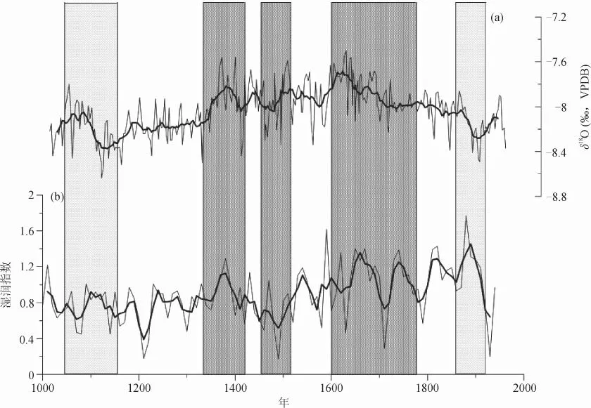
前人的研究已表明,西北地区降水的强弱,与季风强弱关系紧密(Ge et al,2011)。与张平中等人利用万象洞石笋同位素序列指代的夏季风强弱变化(Zhang et al,2008)进行比较,发现自14世纪小冰期开始之后,中国西北季风边缘区的干湿变化与夏季风的强弱有较好的对应关系。图6中灰影显示的3个时段,AD 1350—1400年左右的夏季风偏强,研究区域偏湿,而AD 1470—1520左右的夏季风偏弱,则是西北季风边缘区1000年来最干的时期。在AD 1600—1800年夏季风偏强的时期,也是西北偏湿润的一个时期,尽管这200 a中干湿波动较季风强度的波动剧烈,但是,在浅灰色显示的中世纪温暖期升温过程AD 1000—1150前后,季风强弱和中国西北季风边缘区的干湿变化呈反相关的关系。而在20世纪的升温过程中,二者同样呈反相关关系。
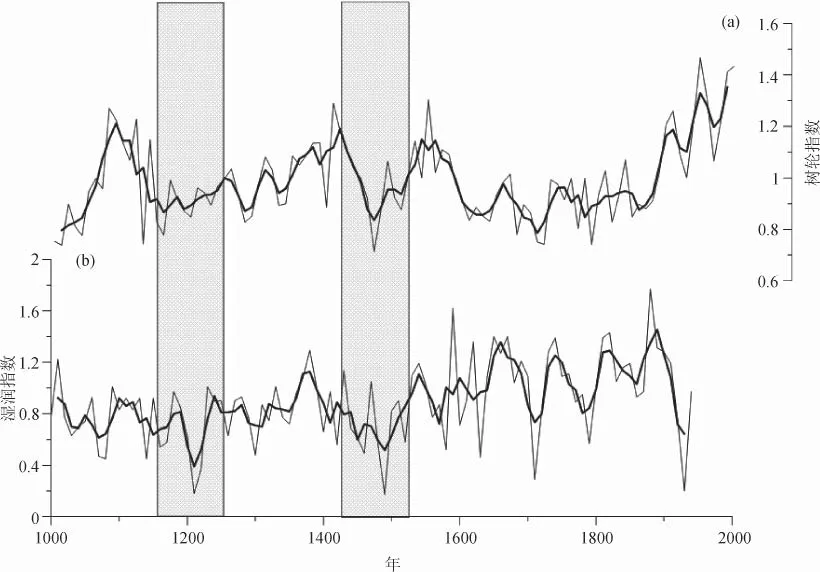
为进一步探讨这种矛盾关系,和树轮重建的非季风区的柴达木盆地东部降水序列(邵雪梅等,2006)相比较,发现二者的干湿变化有很大的差异甚至相反。在AD 1050—1150左右的暖期,非季风区表现为降水偏多,而中国西北季风边缘区则变现出干旱的趋势。在AD 1650—1900左右比较湿润的时期,祁连山非季风区则表现为降水偏少。但从图7灰影表示的时段也可以看出,中国西北季风边缘区最干旱的两个时期,在年轮指代的非季风区也都同样表现出干旱的趋势。
这样看来,在AD 1000—1150中国中世纪温暖期比较暖的时期,季风较强,有可能季风边缘向前推进,导致现在的中国西北季风边缘区转向偏干。而AD 1650—1900年间处在小冰期时期,季风偏强,中国西北季风边缘区的偏湿润,柴达木盆地东部偏干,说明季风边缘未能推进。而AD 1450—1500季风偏弱时期,柴达木盆地东部和中国西北季风边缘区都为千年中最干的两个时期,这个时期也是中国小冰期的一个冷谷(Ge et al,2003),Zhou et al(2011)的研究也表明,这一时期太阳活动偏弱,温度偏低,季风偏弱。这说明中国西北季风边缘区与季风强弱的关系,应是:温度特别暖,季风特强,季风边界前进,该区域偏干。温度偏低,季风偏强,季风边界稳定,该区域偏湿。温度特低,季风特弱,季风边界退缩,区域特干。

图6 (a)为张平中等得出的万象洞石笋δ18O同位素序列,指代夏季风的强弱。粗黑线为30 a滑动平均。(b)中国西北季风边缘区湿润指数。粗黑线为30 a滑动平均。Fig.6 (a) The δ18O data of Wanxiang Cave, represent the intensity of summer monsoon. The bold blue line is the 30-year-running mean of the whole series. (b) Humidity index of Northwest China Monsoon Boundary Zone. The bold black line is the 30-yearrunning mean value.

图7 (a)为邵雪梅等重建的柴达木盆地东部年轮指数,指代非季风区的降水变化。粗黑线为30年移动平均。(b)中国西北季风边缘区湿润指数。粗黑线为30年滑动平均。Fig.7 (a)The index of tree rings in Northeastern Qaidam basin to represent the precipitation series over the past millennium. The bold black line is the 30-year-running mean of the whole series. (b) Humidity index of Northwest China Monsoon Boundary Zone. The bold black line is the 30-year-running mean value.
4 结论
利用历史文献中的旱涝灾害记载,建立了中国西北季风边缘区AD 1000—1949年的逐年湿润指数,能比较好地指代这一区域的干湿变化情况。
在过去千年中,中国西北季风边缘区有一次大的干湿变化的转折,发生在AD 1550年前后。同时存在较明显的60~70 a周期和110 a左右的周期。
季风边缘区的干湿变化和季风系统的活动有关系。暖期时,季风边界推进,传统的季风边缘区将变干燥。温度偏低,季风偏强,季风边界稳定,该区域偏湿。而当季风明显减弱时,季风边界两侧的边缘区和非季风区则因季风边界的退缩而同时变干。
白虎志, 董安祥, 邓广芬, 等. 2010.中国西北地区近五百年旱涝分布图集(1470—2008)[M]. 北京: 气象出版社. [Bai H Z, Dong A X, Deng G F. 2010. Yearly charts of dryness/wetness in China for the last 500-year period (1470—2008) [M]. Beijing: China Meteorological Press.]
冯 雯,李可军,翟 倩,等. 2013.中国北方地区(33°~41°N,108°~115°E)过去500年夏季降水量的周期成分分析[J].第四纪研究, 33(1): 126–135. [Feng W, Li K J, Zhai Q, et al. 2013. Multi-scale analysis of the precipitation index in north-central China (33°~41°N, 108°~115°E) over the past 500 years [J]. Quaternary Sciences, 33(1): 126–135.]
勾晓华, 邓 洋, 陈发虎,等. 2010.黄河上游过去 1234年流量的树轮重建与变化特征分析[J]. 科学通报,55(33): 3236–3243. [Gou X H, Deng Y, Chen F H, et al. 2010. Tree ring based stream-f ow reconstruction for the Upper Yellow River over the past 1234 years [J]. Chinese Science Bulletin, 55(33): 3236–3243.]
康兴成,程国栋,陈发虎,等. 2003.连山中部公元904年以来树木年轮记录的旱涝变化[J]. 冰川冻土, (5): 518–525.[Kang X C, Cheng G D, Chen F H, et al. 2003. A record of drought and f ood series by tree-ring data in the middle section of Qilian Mountain since 904 AD [J]. Journal of Glaciology and Geocrylolgy, (5): 518–525.]
邵雪梅,黄 磊,刘洪滨,等. 2004.树轮记录的青海德令哈地区千年降水变化[J].中国科学(D辑), 34(2): 145–153. [Shao X M, Huang L, Liu H B, et al. 2004. Reconstruction of precipitation variation from tree rings in recent 1 000 years in Delingha, Qingha [J]. Science in China (Series D), 34(2): 145–153.]
邵雪梅,粱尔源,黄 磊,等. 2006.柴达木盆地东北部过去1437 a的降水变化重建[J].气候变化研究进展, 2(3): 122–126.[Shao X M, Liang E Y, Huang L, et al. 2006. A recontracted precipitation series over the past millennium in Northeastern Qaidam Basin [J]. Advanced in Climate Change Research, 2(3): 122–126.]
王绍武,赵宗慈. 1979.近五百年我国旱涝史料的分析[J].地理学报, 34(4): 329–340. [Wang S W, Zhao Z C. 1979. An Analyses of historical data of droughts and floods in last 500 years in China [J]. Acta Geographica Sinica, 34(4): 329–341.]
杨建平,丁永健,陈仁升,等. 2005.亚洲季风与中国干湿、农牧气候界线之关系[J].地理科学, 25(4): 441–447. [Yang J P, Ding Y J, Chen R S, et al. 2005. Relationship of Asian Monsoon with dry and wet climate boundary and agro-pasturing climate boundary [J]. Sicentia Geographica Sinica, 25(4): 441–447.]
袁 林. 1994. 西北灾荒史[M].兰州:甘肃人民出版社. [Yuan L. 1994. History of Famines in Northwest China [M]. Lanzhou: Gansu People's Publishing House.]
张德二. 2004. 中国三千年气象记录总集[M].南京: 凤凰出版社, 江苏教育出版社. [Zhang D E. 2004. A compendium of Chinese meteorological records of the lsat 3000 years [M]. Nanjing: Phoenix Publishing House, Jiangsu Education Publishing House.]
郑斯中, 张福春, 龚高法. 1977. 我国东南地区近两千年气候湿润状况的变化[M]//中央气象局气象科学研究所.气候变化和超长期预报文集. 北京: 科学出版社, 29–32. [Zheng S Z, Zhang F C, Gong G F. 1977. Humid change of Southeast China for the last 2000 years [M]// Chinese Academy of Meteorological Sciences, China Meteorological Administration. Climate change and super long-term forecast collected works. Beijing: Science Press, 29–32.]
中央气象局气象科学研究院.1981.中国近五百年旱涝分布图集[M].北京: 中国地图出版社. [Chinese Academy of Meteorological Sciences, China Meteorological Administration. 1981. Yearly charts of dryness/wetness in China for the last 500-year period [M]. Beijing: SinoMapsPress.]
竺可桢. 1972. 中国近五千年来气候变迁的初步研究[J].考古学报, (1): 15–38. [Chu K C. 1972. Apreliminary study on the climatic f uctuations during the last 5000 years in China [J]. Acta Archaeologica Sinica, (1): 15–38.]
An Z S. 2000. The history and variability of the East Asian paleomonsoon climate [J]. Quaternary Science Reviews. 19: 171–187.
Chen F H, Chen J H, Holmes J A. et al. 2010. Moisture changes over the last millennium in the Arid Central Asia: a review, synthesis and comparison with monsoon region [J]. Quaternary Science Review, 29(7–8): 1055–1068.
Ding Y H, Chan J C L. 2005. The East Asian summer monsoon: an overview [J]. Meteorology and Atmospheric Physics, 89: 117–142.
Ge Q S, Zheng J Y, Fang X Q, et al. 2003. Winter half-year temperature reconstruction for the middle and lower reaches of the Yellow River and Yangtze River, China, during the past 2000 years [J]. Holocene, 13(6): 933–940.
Ge Q S, Hao Z X, Tian Y Y, et al. 2011. The rainy season in the Northwestern part of the East Asian Summer Monsoon in the 18th and 19th centuries [J]. Quaternary International, 229 :16–23.
Gu Y J, Wang H L, Liu J. 2010. Latitudinal-dependent Response of East Asian Summer Monsoon to External Forcing in the Last Millennium [J]. Acta Meteorologica Sinica, 24(6): 671–679.
Shi Y F, Shen Y P, Kang E S, et al. 2007. Recent and future climate change in northwest China [J]. Climatic Change, 80(3–4): 379–393.
Tao S Y, Chen L X. 1985. The East Asian summer monsoon. Proceedings of International Conference on Monsoon in the Far East [C]. Tokyo, 5—8 Nov, 1–11.
Zhang P Z, Cheng H, Edwards R L, et al. 2008. A test of climate, sun and culture relationships from an 1810-year Chinese cave records [J]. Science, 322: 940–942.
Zhang Q B, Cheng G D, Yao T D, et al. 2003. A 2,326-year tree-ring record of climate variability on the northeastern Qinghai-Tibetan Plateau [J]. Geophysical Research Letters, 30(14), 1739, doi:10.1029/2003GL017425.
Zhang Y, Gou X H, Chen F H, et al. 2009. A 1232-year tree-ring record of climate variability in the Qilian Mountains north western China [J]. IAWA Journal, 30(4): 407–420.
Zheng J Y, Wang W C, Ge Q S, et al. 2006. Precipitation variability and extreme events in eastern China during the past 1500 years [J]. Terrestrial, Atmospheric and Oceanic Sciences, 17(3): 579–592.
Zhou X J, Zhao P, Liu G, et al. 2011. Characteristics of decadalcentennial-scale changes in East Asian summer monsoon circulation and precipitation during the Medieval Warm Period and Little Ice Age and in the present day [J]. Chinese Science Bulletin, 56(28–29): 3003–3011.
The reconstruction of dry and wet variation in monsoon boundary zone of northwest China by records of historical documents over the past millennium
YANG Yu-da, HAN Jian-fu, CHENG Sai-nan
(Institute of Chinese Historical Geography, Fudan University, Shanghai 200433, China)
This paper reconstructs humidity index series of CNWMBZ (northwest China monsoon boundary zone) from 1000 to 1949 AD. by Chinese historical documents, to analyze the dry/wet variation of the study area. The reconstruction result shows a turning point at around 1550 AD. Before 1550 AD, the climate of CNWMBZ is generally dry, while the climate shifts to wet after 1550 AD. There are also inter-centennial fluctuations of dry and wet phases during the last millennium. The wavelet analysis on the humidity index of CNWMBZ exhibits periodicity at 60~70-year and 110-year. Comparisons with the dry/wet variation of the non-monsoon region reconstructed by tree ring and with the summer monsoon intensity rebuilt by cave records demonstrate that, the dry/wet variation of CNWMBZ is closely related with the monsoon system. During the warm period, the monsoon region boundary moves forward, the study area (i.e. the CNWMBZ) exhibits dry tendency; during the comparatively cold period, the summer monsoon is relatively strong, the monsoon boundary is generally stable, the study area is comparatively wet; during the very cold period, the summer monsoon is very weak, the monsoon boundary retreats, the study area and the non-monsoon region both show dry tendency.
summer monsoon; monsoon boundary zone; dry/wet variation; millennium; historical documents; northwest China
P467
:A
:1674-9901(2014)06-0392-08
10.7515/JEE201406005
2014-10-31
教育部全国优秀博士学位论文作者专项资金资助项目(201114)
韩健夫,E-mail: 12210760003@fudan.edu.cn

