行走柬埔寨,寻觅失落城
by Lara Dunston
Its 7 a.m. at 2)Angkor Wat and theres not a tourist in sight. Its blissfully quiet, the first clear June morning after two days of 3)torrential rains. The only souls around are a small group of Buddhist pilgrims, lighting 4)incense at the rear of the spectacular 5)Khmer temple. The 6)bleary-eyed early-risers, who woke in darkness to board tour buses to Angkor 7)archaeological park for sunrise 8)photo ops, have already 9)trundled back to their breakfast buffets. Im not here for sightseeing, however, Im heading further into the forest surrounding the 10)stupendous temple complex with Australian archaeologist Dr Damian Evans to meet the archaeologists from Cambodia, the Philippines and the USA, who are working on new 11)excavations.
The release by the 12)US National Academy of Sciences of a report on the results of a high-tech survey of Khmer Empire sites, undertaken in April 2012, has rocked the archaeological world and captured travelers imaginations. Evans was one of the report authors and the lead archaeologist and director of the project, which only became known outside local and archaeological circles with the release of the report.
As we make our way through dense vegetation, he explains how eight key archaeological groups collaborated on the project. It began with a survey using an airborne laser scanning instrument called Lidar, strapped to a helicopter, to search for ruins and other structures. “For archaeologists, these lumps and bumps that we see in the forest, each has a meaning,” Evans explains, pointing out gentle 13)mounds. “These are all the traces of the civilisation of the city associated with Angkor Wat, made of wood and 14)thatch, that has disappeared. Its these 15)contours that remain inscribed into the forest landscape we study.”
“Were really interested in understanding residence patterns, where and how people lived and who they were,” Evans explains excitedly, showing me X-ray-like images of the area were in.
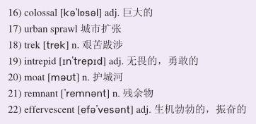
Scholars have long based their ideas of all medieval cities around the world on European cities, explains Professor Roland Fletcher, director of the Greater Angkor Project. But now, it seems there was a 16)colossal low-density 17)urban sprawl here. “This is a highly managed system, the most extensive pre-industrial city in the world,” he says, though referring to its complexity rather than its size. “The Lidar results show there were three cities [here] at the end of the 9th century—the largest was on top of Mount Kulen, creating an [equivalent to] industrial 19thcentury Britain.”
We decide to head to one of the local Phnom Kulen, a site rarely visited by tourists, with just a few companies offering expeditions and 18)treks there. “Phnom Kulen is a sacred mountain, a holy place for Cambodians,” Tat, our guide from Backyard Travel tells us en route. While it may not be the dramatic mist-shrouded peak I imagined, the 492m-high, 8km-wide and 32km-long mountain is visible for the whole 90-minute drive north from Siem Reap to the foothills of Mount Kulen national park. We leave our air-conditioned four-wheel drive behind and soon were bouncing along muddy tracks on the back of motorbikes behind guides familiar with the landmine-riddled mountainside, once the last stronghold of the Khmer Rouge.
Its a slow journey, over narrow, bumpy dirt trails—only the most 19)intrepid travelers come here. We cross log bridges and ride straight through flowing streams. Scattered across the mountain are ruined, foliage-covered temples, ancient highway markers and, at Sras Damrei or Elephant Pond, massive statues of an elephant and lions. The thought that more sites like this could soon be discovered is thrilling.
Back in Siem Reap we take to the air in a helicopter to get a better idea of what this urban landscape might have looked like. Had I taken the flight two weeks ago, I would have gasped at the magnificence of the isolated temple structures with their imposing walls and 20)moats surrounded by forests. Now, I see patterns of bumps and lines on the vast floodplain as beautiful 21)remnants of an immense, 22)effervescent city that technology and archaeology are finally bringing to life.
While many believe this site will become one of Asias greatest wonders, and tourism bodies are eager to see excavations progress quickly and more archaeological sites opened up to visitors, the extraordinary size of the area means work will be costly and take years. In the meantime, however, the intrepid can play at being Indiana Jones at undeveloped sites on Phnom Kulen, and temple cities such as Beng Mealea and Koh Ker—and let their imaginations run wild.
清早七点钟的吴哥窟,眼前一位游客都没有。两天的倾盆大雨过后,六月里第一个晴朗的清晨,一片令人欣喜的宁静。周遭唯有前来朝拜的三两佛教徒,在壮观的高棉寺庙后头点起了香。那些因为早起而睡眼惺忪的人们在黑暗中醒来,登上旅游巴士赶到吴哥古迹公园拍摄完日出后,已经步履蹒跚地返回去享用他们的自助早餐。我并非到此观光,而是与澳大利亚考古学家达米安·埃文斯博士一起深入环绕着这宏伟庙宇群的森林,同来自柬埔寨、菲律宾和美国一批致力于新发掘工作的考古学家们会面。
美国国家科学院发布了一份报告,公布了自2012年4月以来通过高科技对高棉帝国遗址进行勘测的研究成果,不仅轰动了整个考古界,还激起了旅行者们的遐想。埃文斯是报告的执笔人之一,也是项目的首席考古学家和负责人。随着报告的发布,这一项目才被除当地人和考古界圈内人以外的人们所了解。
当我们穿过茂密的植被前行时,他解释着这个项目的八支主力考古队是如何分工合作的。最初是利用一部绑在直升机上的名为“利达尔”的机载激光扫描仪进行勘测,搜寻遗址和其他建筑物。“对于考古学家们来说,我们在这片森林里看到的这些土垄块突都有着不同的意义。”埃文斯指着一处处平缓起伏的土丘解释说。“这些全都是这座与吴哥窟相关的城市留下的文明印记,由木头和茅草搭建而成的建筑物如今早已消失,而遗迹的轮廓则刻画留存在我们所研究的这片森林的地形里。”
“我们实在好奇当时的居住模式,人们生活的地点、方式,以及他们的身份,” 埃文斯一边向我展示着我们所在区域的像X光片一样的图像,一边兴奋地解释说。
大吴哥研究计划的负责人罗兰·弗莱彻教授解释说,长久以来,学者们都以欧洲城市作为研究世界各地中世纪城市的理论基础。但如今看来,似乎有一个巨大的低密度城市曾在这里扩展。“这是一个高度管理的系统,前工业化时期世界上最广阔的城市,”他说,尽管指的是它的复杂性而非其面积。“利达尔的勘测结果显示,在公元九世纪末期,(这里)曾有三座城市——最大的那座位于荔枝山顶,缔造了一个(相当于)19世纪工业化的英国。”
我们决定前往荔枝山的一头,这片遗址极少有游客观光,只有少数几个提供考察和旅行的公司驻扎在那里。“荔枝山是座圣山,对于柬埔寨人来说,是个圣地,”我们来自于“后院旅行社”的导游塔特在路上告诉我们。尽管它或许不是我想象中那种引人入胜的云雾缭绕的山峰,但这座高492米,宽8公里,长32公里的山峦在从暹粒以北到荔枝山国家公园山麓沿途整个90公里的车程中都清晰可见。我们走出空调四驱车,随即骑上摩托车,跟在对地雷密布的山坡地区了如指掌的向导们后面,在布满泥泞的小道上一路颠簸前行。这里曾经是红色高棉组织最后的大本营。
这是一段缓慢的旅程,行进在狭窄、崎岖、脏兮兮的小路上——只有最勇敢无畏的旅行者才会来这里。我们经过了木桥,直接骑过流水。盖满落叶的破败寺庙、古老的道路标识洒落在山间,而在大象池,则可见巨大的大象或狮群雕像。一想到更多像这样的遗址将被发掘出来,我们就感到无比振奋。
回到暹粒市,我们乘上直升机俯瞰,以便更好地了解这座城市曾经可能呈现出的风光。如果我在两个星期之前曾体验过这样的飞行,被森林环绕隔绝的寺庙建筑群及其宏伟的山墙和护城河所营造的壮丽美景一定已经让我惊叹不已。而如今,我在涝原上看出了旧文明的土垄列迹,那是一座曾经广阔而生机勃勃的城市留下的美丽残迹。在科技和考古学的作用下,这座城市终于得以复生。
尽管许多人相信,这片遗址将会变成亚洲最伟大的奇迹之一,旅游业界也热切地期盼着发掘项目能快速进行,更多的考古遗址能向游客开放,但这片地区非同寻常的面积也意味着发掘工作成本昂贵且时间漫长。不过同时,勇士们也能在暹粒荔枝山那些尚未发掘的遗址及像崩密列和贡开这样的寺庙城,一尝印第安纳·琼斯的滋味——任由他们的想象力肆意狂奔。
小资料
亚特兰蒂斯,又称大西国,关于它的传说始于古希腊的哲学之祖——柏拉图。传说中亚特兰蒂斯是拥有着高度发达史前文明的古老大陆。据《梵蒂冈城国古抄本》中描述,当时的大西国生活着地球上的第四代人类,即处于“太阳与水”阶段的人类,这一阶段的人类文明灭亡于大洪灾。1969年7月,人们在北比米尼群岛发现了用作装饰的古希腊样式的大理石圆柱,但最终却发掘无果。至今,无人敢为这个古国存在的真实性打包票。
位于中国新疆巴音郭楞蒙古族自治州若羌县北境、罗布泊以西的楼兰王国,于公元4世纪之后,销声匿迹。专家猜测楼兰的消亡是由于人类违背自然规律而导致的,楼兰人盲目滥砍乱伐致使水土流失、风沙侵袭、河流改道、气候反常、瘟疫流行、水分减少、盐碱日积,最终造成了王国的灭亡。1900年3月,瑞典籍探险家斯文·赫定在寻找罗布泊的行程中意外发现了楼兰古城,自此楼兰王国神秘的面纱被撩开了一角。

